 Old Cumbria Gazetteer
 |
 |
|
| Eye Holes, Lancashire | ||
| Eye Holes | ||
| Eyeholes | ||
| site name:- | Gragareth | |
| site name:- | Leck Fell | |
| county:- | Lancashire | |
| locality type:- | pothole | |
| locality type:- | cave | |
| coordinates:- | SD668792 | |
| 1Km square:- | SD6679 | |
| 10Km square:- | SD67 | |
| altitude:- | 1120 feet | |
| altitude:- | 341m | |
| SummaryText:- | Grade II; permission from Council of Northern Caving Clubs. | |
| references:- | Balderston c1890 map Brook, D & Davies, G & Long, M H &Sutcliffe, J R: 1975: Northern Caves, vol.4 Whernside and Gragareth: Dalesman Books:: ISBN 0 85206 259 1 |
|
|
|
||
| evidence:- | descriptive text:- Balderston c1890 placename:- Eye Holes |
|
| source data:- | Book, Ingleton, Bygone and Present, by Robert R and Margaret
Balderston, published by Simpkin, Marshall and Co, London, and
by Edmndson and Co, 24 High Street, Skipton, Yorkshire, about
1890. goto source goto sourcepage 72:- "..." "The Eye Holes." "Retracing one's steps down the field [Fenwick's Allotment], two remarkable pairs of holes, like cavities of the orbits in a skull, having an intervening natural bridge of rock, are discovered not far below. The upper pair has small holes, but the left eye, looking northwards, is forty-five feet deep. The lower pair is of much larger size with a massive stone arch between, about five feet wide, but the right eye, the deeper of the two, is only seventeen feet deep." |
|
|
|
||
| evidence:- | old map:- Balderston c1890 map placename:- Eye Holes and Cave |
|
| source data:- | Map, the hills in the Ingleton area, probably by Robert R
Balderston, engraved by Goodall and Suddick, Leeds, West
Yorkshire, about 1890.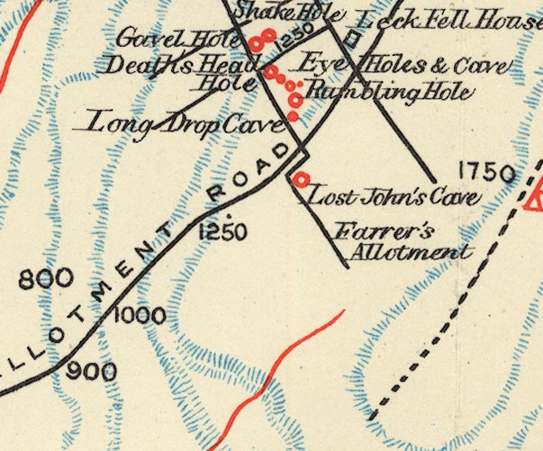 BS1SD67U.jpg "Eye Holes &Cave" item:- private collection : 27.1 Image © see bottom of page |
|
|
|
||
Lakes Guides menu.