 Old Cumbria Gazetteer
 |
 |
|
| Black Gill (2) | ||
| runs into:- |  Comb Gill (5) Comb Gill (5) |
|
|
|
||
| Black Gill | ||
| locality:- | Thornthwaite Forest | |
| civil parish:- | Above Derwent (formerly Cumberland) | |
| county:- | Cumbria | |
| locality type:- | river | |
| 1Km square:- | NY2125 (etc) | |
| 10Km square:- | NY22 | |
|
|
||
| evidence:- | old map:- OS County Series (Cmd 63 4) placename:- Black Gill |
|
| source data:- | Maps, County Series maps of Great Britain, scales 6 and 25
inches to 1 mile, published by the Ordnance Survey, Southampton,
Hampshire, from about 1863 to 1948. |
|
|
|
||
| evidence:- | perhaps old drawing:- Green 1790s-1820s (1807) |
|
| source data:- | Drawing, pencil, Waterfall on Coum Gill in Borrowdale, probably Black Gill in Comb
Gill, Above Derwent, Cumberland, by William Green, Ambleside, Westmorland, 16 August
1807.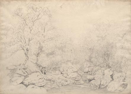 click to enlarge click to enlargePR1758.jpg ms, pencil at lower left, right:- "Augt 16 1807 / Water fall on Coum Gill in Borrowdale" item:- Dove Cottage : B45 Image © see bottom of page |
|
|
|
||
Lakes Guides menu.