 Old Cumbria Gazetteer
 |
 |
|
| Parton Tunnel, Whitehaven | ||
| Parton Tunnel | ||
| site name:- | tramroad, Bransty | |
| locality:- | Redness Point | |
| civil parish:- | Whitehaven (formerly Cumberland) | |
| county:- | Cumbria | |
| locality type:- | railway tunnel | |
| coordinates:- | NX97341952 (etc) | |
| 1Km square:- | NY9719 | |
| 10Km square:- | NX91 | |
|
|
||
| evidence:- | old map:- OS County Series (Cmd 61 14) |
|
| source data:- | Maps, County Series maps of Great Britain, scales 6 and 25
inches to 1 mile, published by the Ordnance Survey, Southampton,
Hampshire, from about 1863 to 1948.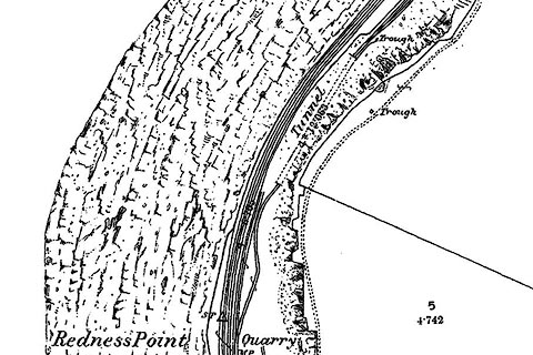 click to enlarge click to enlargeCSRY0208.jpg "Tunnel" On a tramroad leading along the shore to a Coal Depot just S of Parton |
|
|
|
||
| evidence:- | old painting:- |
|
| source data:- | Painting, watercolour, The Solway from Parton Tunnel, by William Henry Nutter, 1841. click to enlarge click to enlargeCCB77.jpg in pencil at bottom:- "Distant [ ] at the Scottish [ ] coast & the Solway frith from the tunnel near Parton [near] Whitehaven Cumberland [Nov] 4th 1841" courtesy of Abbot Hall Art Gallery, Kendal item:- Abbot Hall : S84 Image © Abbot Hall Art Gallery, Kendal |
|
|
|
||
 Lakes Guides menu.