 Old Cumbria Gazetteer
 |
 |
|
| included in:- |
 Hill Cottage, Longsleddale Hill Cottage, Longsleddale |
|
| Hill Cottage, Longsleddale: Corn Rent Act 1836 | ||
| evidence:- | tithe schedule:- Kendal Corn Rent Act 1836 placename:- Hill |
|
| source data:- | Tithe map, Plan of part of the Township of Longsleddale, Westmorland, made regarding
the Kendal Corn Rent Act, ie a tithe award map, scale about 20 inches to 1 mile, Kendal,
Westmorland, 1836. Schedule, each row gives:- Field no. / Tenant's name / Close ie Field name / Type of culture / Area, acres Owned by Robert Bateman, tenanted by Samuel Taylor; Hill. "/ / Bateman Robert" "/ 335 / Samuel Taylor / Barn Close / Pas / 3 00[0]" "/ 336 / Do / Broad Meadow / Mea / 2 435" "/ 337 / Do / Little Walls / Mea / 2 515" "/ 338 / Do / Far Walls / Mea / 3 575" "/ 338 / Do / Wood in do. / / 0 630" "/ 339 / Do / Long Ing / Mea / 4 825" "/ 340 / Do / Homestead &c at Hill / / 0 190" "/ 341 / Do / Calf Parrock / Pas / 0 515" "/ 342 / Do / Swine Rigg / Pas / 2 420" "/ 343 / Do / Grassing / Pas / 17 225" "/ 344 / Do / Intake / Ar &Mea / 7 325" "/ 345 / 5/28 pt. Do / Cockley Fell / Pas / 47 315" "/ / / / / [total] 91 970" "" 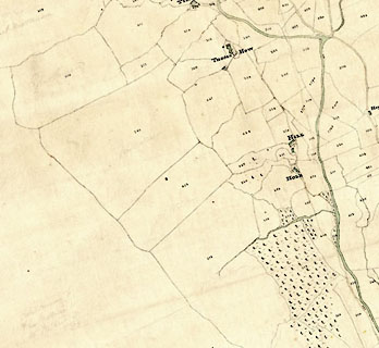 click to enlarge click to enlargeCRny4804.jpg map courtesy of Mark Cropper item:- private collection : 370 Image © see bottom of page |
|
|
|
||
| evidence:- | tithe awards:- Kendal Corn Rent Act 1836 placename:- Hill |
|
| source data:- | Plan of the Township of Longsleddale, made for the Kendal Corn Rent Act, ie a tithe
award map, scale about 10 inches to 1 mile, Kendal, Westmorland, 1836. "Bateman Robert / Samuel Taylor / Hill / 91 970 91 3 35 / ..." |
|
|
|
||
Lakes Guides menu.