 Old Cumbria Gazetteer
 |
 |
|
| included in:- |
 Hollin Root, Longsleddale Hollin Root, Longsleddale |
|
| Hollin Root, Longsleddale: Corn Rent Act 1836 | ||
| evidence:- | tithe schedule:- Kendal Corn Rent Act 1836 placename:- Hollin Root |
|
| source data:- | Tithe map, Plan of part of the Township of Longsleddale, Westmorland, made regarding
the Kendal Corn Rent Act, ie a tithe award map, scale about 20 inches to 1 mile, Kendal,
Westmorland, 1836. Schedule, each row gives:- Field no. / Tenant's name / Close ie Field name / Type of culture / Area, acres Owned by William Sleddall, tenanted by John Dixon; Hollin Root. "/ / Sleddall William" "/ 275 / John Dixon 51/253 pts or 25½Gaits on / Sleddale Forest / Pas / 200 235" "/ 294 / Do / Wells Parrock / Pas / 1 475" "/ 295 / Do / Back Spring Wood / / 10 105" "/ 296 / Do / Back Spring Bank / Pas &Md / 14 000" "/ 297 / Do / Thorney Parrock / Pas / 1 215" "/ 298 / Do / High Wads How fld. / Mea / 3 030" "/ 299 / Do / Low do do / Ar &Mea / 3 825" "/ 300 / Do / Holme / Mea / 2 500" "/ 301 / Do / Low Meadow / Mea / 2 310" "/ 302 / Do / Lowfield / Ar &Mea / 1 310" "/ 303 / Do / Littlefield / Ha y/ 1 180" "/ 304 / Do / Whity Parrock / Pas / 1 785" "/ 305 / Do / Homstd. Lane &c at Hollin Root / / 1 075" "/ 305a / Do / Plantation / / 0 155" "/ 306 / Do / Orchard / / 0 105" "/ 307 / Do / Tup Parrock / Ar. / 2 400" "/ 308 / Do / Great Wood / / 13 575" "/ 309 / Do / Great Wood Bank / Pas / 5 840" "/ 310 / Do / Plantation / / 0 900" "/ / / / / [total] 267 020" "" 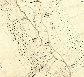 click to enlarge click to enlargeCRny4903.jpg map courtesy of Mark Cropper item:- private collection : 370 Image © see bottom of page |
|
|
|
||
| evidence:- | tithe awards:- Kendal Corn Rent Act 1836 placename:- Hollin Root |
|
| source data:- | Plan of the Township of Longsleddale, made for the Kendal Corn Rent Act, ie a tithe
award map, scale about 10 inches to 1 mile, Kendal, Westmorland, 1836. "Sleddall William / John Dixon / Hollin Root / 267 020 267 + 3 / ..." |
|
|
|
||
Lakes Guides menu.