 Old Cumbria Gazetteer
 |
 |
|
| included in:- |
 Middale, Longsleddale Middale, Longsleddale |
|
| Middale, Longsleddale: Corn Rent Act 1836 | ||
| evidence:- | tithe schedule:- Kendal Corn Rent Act 1836 placename:- |
|
| source data:- | Tithe map, Plan of part of the Township of Longsleddale, Westmorland, made regarding
the Kendal Corn Rent Act, ie a tithe award map, scale about 20 inches to 1 mile, Kendal,
Westmorland, 1836. Schedule, each row gives:- Field no. / Tenant's name / Close ie Field name / Type of culture / Area, acres Owned by James Mattinson, tenanted by John and James Mattinson; Mid Dale. "/ / Mattinson James" "/ 362 / Jno & Jas. Mattinson / Orchard End / Ar &Mea/ 1 445" "/ 363 / Do / Builds &c at Mid Dale / / 0 180" "/ 364 / Do / Low Croft / Pas / 6 185" "/ 365 / Do / Drift Road / Pas / 0 335" "/ 366 / Do / Thorny parrock / Pas / 1 015" "/ 367 / Do / Wood / Pas / 22 715" "/ 368 / Do / Grassing / Pas / 44 000" "/ 369 / Do / High Croft / Pas / 3 500" "/ 370 / Do / Plantation / / 0 465" "/ 371 / Do / Back o't' Barn / Mea / 1 220" "/ 372 / Do / Medow / Mea / 5 120" "/ 554 / Do ¼of / Grassing Heads / Pas / 26 075" "/ / / / / [total] 112 255" "" 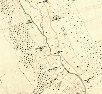 click to enlarge click to enlargeCRny4903.jpg map courtesy of Mark Cropper item:- private collection : 370 Image © see bottom of page |
|
|
|
||
| evidence:- | tithe awards:- Kendal Corn Rent Act 1836 placename:- Mid Dale |
|
| source data:- | Plan of the Township of Longsleddale, made for the Kendal Corn Rent Act, ie a tithe
award map, scale about 10 inches to 1 mile, Kendal, Westmorland, 1836. "Mallinson James / Jno. &Jas. Mattinson / Mid Dale / 112 255 112 1 1 / ..." |
|
|
|
||
Lakes Guides menu.