 Old Cumbria Gazetteer
 |
 |
|
|||||||||||||||||||||||||||||||||
| included in:- |
 road, Lancaster to Carlisle road, Lancaster to Carlisle |
||||||||||||||||||||||||||||||||||
| road, Lancaster to Kendal W | |||||||||||||||||||||||||||||||||||
| A6 | |||||||||||||||||||||||||||||||||||
| locality:- | Lancaster | ||||||||||||||||||||||||||||||||||
| county:- | Lancashire | ||||||||||||||||||||||||||||||||||
| civil parish:- | Beetham (formerly Westmorland) | ||||||||||||||||||||||||||||||||||
| civil parish:- | Milnthorpe (formerly Westmorland) | ||||||||||||||||||||||||||||||||||
| civil parish:- | Kendal (formerly Westmorland) | ||||||||||||||||||||||||||||||||||
| county:- | Cumbria | ||||||||||||||||||||||||||||||||||
| locality type:- | road route | ||||||||||||||||||||||||||||||||||
| 10Km square:- | SD46 | ||||||||||||||||||||||||||||||||||
| 10Km square:- | SD57 | ||||||||||||||||||||||||||||||||||
| 10Km square:- | SD58 | ||||||||||||||||||||||||||||||||||
| 10Km square:- | SD59 | ||||||||||||||||||||||||||||||||||
| SummaryText:- | Westerly route from Lancaster to Carnforth, through Beetham or Burton to Milnthorpe, thence to Kendal | ||||||||||||||||||||||||||||||||||
|
|
|||||||||||||||||||||||||||||||||||
| evidence:- | old map:- OS County Series (Lan 18) |
||||||||||||||||||||||||||||||||||
| source data:- | Maps, County Series maps of Great Britain, scales 6 and 25
inches to 1 mile, published by the Ordnance Survey, Southampton,
Hampshire, from about 1863 to 1948. "CARNFORTH AND ULVERSTON TRUST" along road |
||||||||||||||||||||||||||||||||||
|
|
|||||||||||||||||||||||||||||||||||
| route parts:- |  Carnforth to Milnthorpe via Beetham Milnthorpe to Kendal Carnforth to Milnthorpe via Beetham Milnthorpe to Kendal |
||||||||||||||||||||||||||||||||||
|
|
|||||||||||||||||||||||||||||||||||
| route parts:- | alternative route Lancaster to Kendal via Burton, as far as Burton Burton to Milnthorpe Milnthorpe to Kendal |
||||||||||||||||||||||||||||||||||
|
|
|||||||||||||||||||||||||||||||||||
| evidence:- | old map:- Jefferys 1770 (Wmd) |
||||||||||||||||||||||||||||||||||
| source data:- | Map, 4 sheets, The County of Westmoreland, scale 1 inch to 1
mile, surveyed 1768, and engraved and published by Thomas
Jefferys, London, 1770.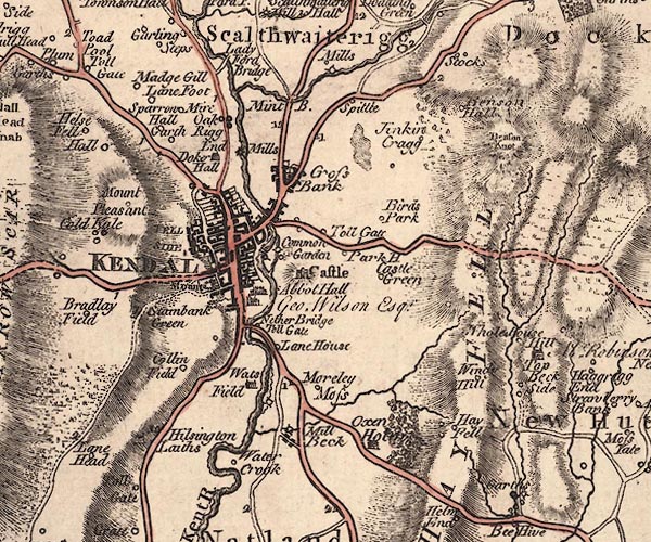 J5SD59SW.jpg 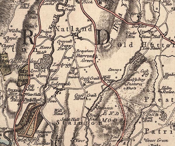 J5SD58NW.jpg 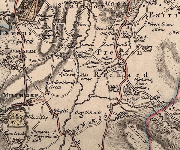 J5SD58SW.jpg 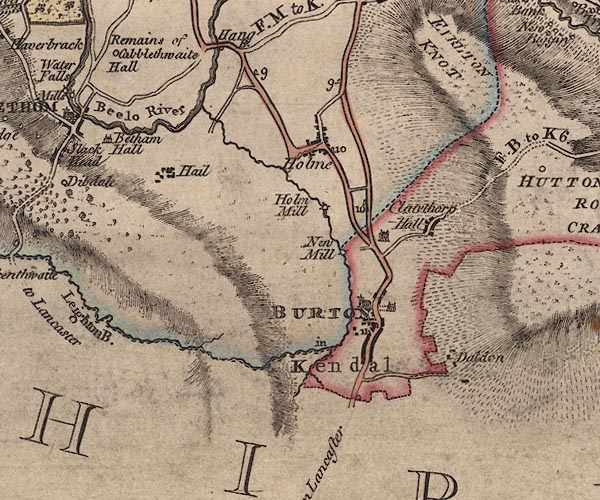 J5SD57NW.jpg "to Lancaster" double line; road, bold, main road, with mile numbers between Kendal and Milnthorpe item:- National Library of Scotland : EME.s.47 Images © National Library of Scotland |
||||||||||||||||||||||||||||||||||
|
|
|||||||||||||||||||||||||||||||||||
| evidence:- | old map:- Cary 1789 (edn 1805) |
||||||||||||||||||||||||||||||||||
| source data:- | Map, uncoloured engraving, Westmoreland, scale about 2.5 miles
to 1 inch, by John Cary, London, 1789; edition 1805.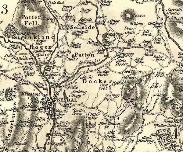 CY24SD59.jpg double line, bold light, numbered miles; main road, two routes 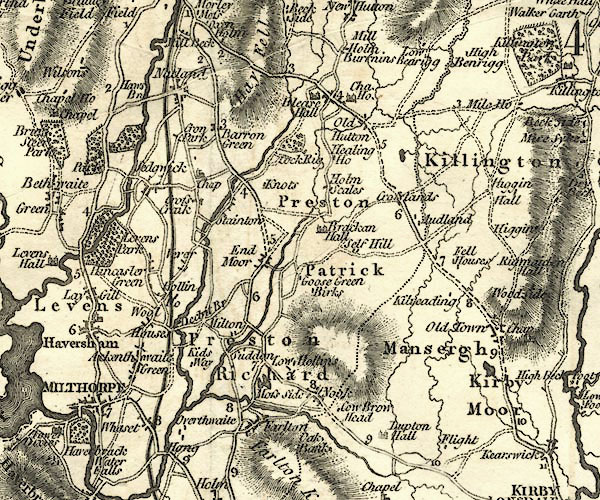 CY24SD58.jpg double line, bold light, numbered miles; main road; two routes 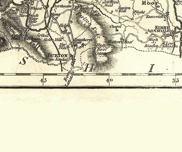 CY24SD57.jpg "From Lancaster" double line, bold light, numbered miles; main road; routes diverge north of Burton item:- JandMN : 129 Image © see bottom of page |
||||||||||||||||||||||||||||||||||
|
|
|||||||||||||||||||||||||||||||||||
| evidence:- | road map:- Cary 1790 (Lan/edn 1792) |
||||||||||||||||||||||||||||||||||
| source data:- | Road map, hand coloured engraving, Lancashire, scale about 18
miles to 1 inch, by John Cary, 181 Strand, London, 1790, edn
1792. click to enlarge click to enlargeCY46.jpg "to Kendal" double line item:- JandMN : 418 Image © see bottom of page |
||||||||||||||||||||||||||||||||||
|
|
|||||||||||||||||||||||||||||||||||
| evidence:- | road map:- Cary 1790 (Wmd/edn 1792) |
||||||||||||||||||||||||||||||||||
| source data:- | Road map, hand coloured engraving, Westmoreland, scale about
11.5 miles to 1 inch, by John Cary, 181 Strand, London, 1790,
edn 1792.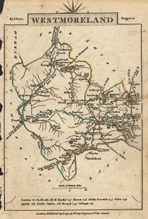 click to enlarge click to enlargeCY16.jpg "to Lancaster" double line, with road distances from Kendal item:- JandMN : 44 Image © see bottom of page |
||||||||||||||||||||||||||||||||||
|
|
|||||||||||||||||||||||||||||||||||
| evidence:- | old map:- Cooke 1802 |
||||||||||||||||||||||||||||||||||
| source data:- | Map, Westmoreland ie Westmorland, scale about 12 miles to 1
inch, by George Cooke, 1802, published by Sherwood, Jones and
Co, Paternoster Road, London, 1824. click to enlarge click to enlargeGRA1Wd.jpg "to Lancaster." double line item:- Hampshire Museums : FA2000.62.4 Image © see bottom of page |
||||||||||||||||||||||||||||||||||
|
|
|||||||||||||||||||||||||||||||||||
| evidence:- | old map:- Laurie and Whittle 1806 |
||||||||||||||||||||||||||||||||||
| source data:- | Road map, Completion of the Roads to the Lakes, scale about 10
miles to 1 inch, by Nathaniel Coltman? 1806, published by Robert
H Laurie, 53 Fleet Street, London, 1834. click to enlarge click to enlargeLw18.jpg light line; 'Other Direct Roads from LONDON' through Milnthorpe item:- private collection : 18.18 Image © see bottom of page |
||||||||||||||||||||||||||||||||||
|
|
|||||||||||||||||||||||||||||||||||
| evidence:- | old map:- Wallis 1810 (Wmd) |
||||||||||||||||||||||||||||||||||
| source data:- | Road map, Westmoreland, scale about 19 miles to 1 inch, by James
Wallis, 77 Berwick Street, Soho, 1810, published by W Lewis,
Finch Lane, London, 1835? click to enlarge click to enlargeWAL5.jpg double line, hatched; 'Mail Coach Road', through Beetham item:- JandMN : 63 Image © see bottom of page |
||||||||||||||||||||||||||||||||||
|
|
|||||||||||||||||||||||||||||||||||
| evidence:- | old map:- Hall 1820 (Wmd) |
||||||||||||||||||||||||||||||||||
| source data:- | Map, hand coloured engraving, Westmoreland ie Westmorland, scale
about 14.5 miles to 1 inch, by Sidney Hall, London, 1820,
published by Samuel Leigh, 18 Strand, London, 1820-31. click to enlarge click to enlargeHA18.jpg single line item:- Armitt Library : 2008.14.58 Image © see bottom of page |
||||||||||||||||||||||||||||||||||
|
|
|||||||||||||||||||||||||||||||||||
| evidence:- | descriptive text:- Ford 1839 (3rd edn 1843) |
||||||||||||||||||||||||||||||||||
| source data:- | Guide book, A Description of Scenery in the Lake District, by
Rev William Ford, published by Charles Thurnam, Carlisle, by W
Edwards, 12 Ave Maria Lane, Charles Tilt, Fleet Street, William
Smith, 113 Fleet Street, London, by Currie and Bowman,
Newcastle, by Bancks and Co, Manchester, by Oliver and Boyd,
Edinburgh, and by Sinclair, Dumfries, 1839. goto source Page 151:- "..." "I. LANCASTER TO KENDAL, BY MILNTHORPE,- 21¼M."
|
||||||||||||||||||||||||||||||||||
|
|
|||||||||||||||||||||||||||||||||||
| evidence:- | old map:- Ford 1839 map |
||||||||||||||||||||||||||||||||||
| source data:- | Map, uncoloured engraving, Map of the Lake District of
Cumberland, Westmoreland and Lancashire, scale about 3.5 miles
to 1 inch, published by Charles Thurnam, Carlisle, and by R
Groombridge, 5 Paternoster Row, London, 3rd edn 1843.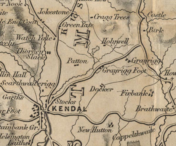 FD02SD59.jpg 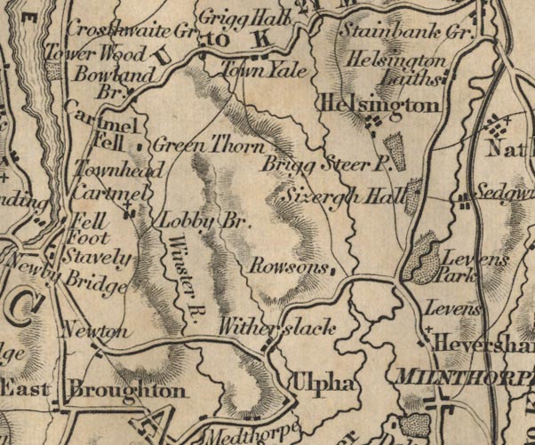 FD02SD48.jpg 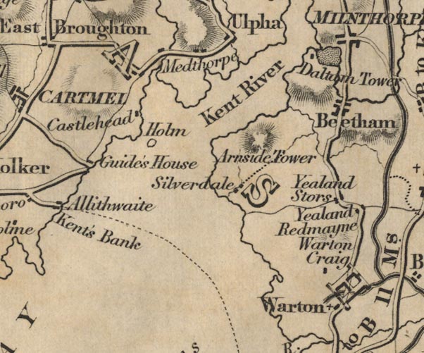 FD02SD47.jpg 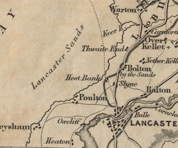 FD02SD46.jpg double line, bold light, major road item:- JandMN : 100.1 Image © see bottom of page |
||||||||||||||||||||||||||||||||||
|
|
|||||||||||||||||||||||||||||||||||
| evidence:- | old map:- Garnett 1850s-60s H |
||||||||||||||||||||||||||||||||||
| source data:- | Map of the English Lakes, in Cumberland, Westmorland and
Lancashire, scale about 3.5 miles to 1 inch, published by John
Garnett, Windermere, Westmorland, 1850s-60s.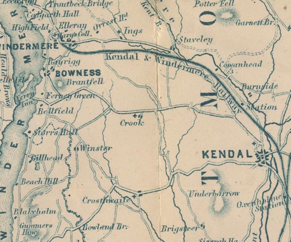 GAR2SD49.jpg double line, bold light, major road 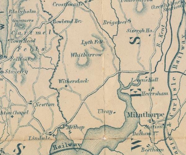 GAR2SD48.jpg 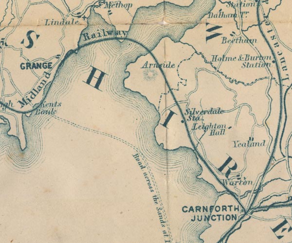 GAR2SD47.jpg 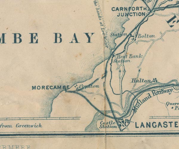 GAR2SD46.jpg item:- JandMN : 82.1 Image © see bottom of page |
||||||||||||||||||||||||||||||||||
|
|
|||||||||||||||||||||||||||||||||||
| evidence:- | gradient diagram:- Gall and Inglis 1890s-1900s (Roads) |
||||||||||||||||||||||||||||||||||
| source data:- | Contour Road Book of England, Northern Division, by Harry R G Inglis, published by
Gall and Inglis, 25 Paternoster Square, London and Edinburgh, 1898.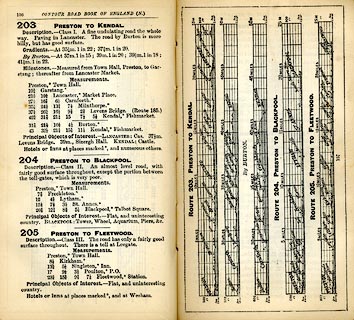 click to enlarge click to enlargeIG5203.jpg Itinerary, with gradient diagram, route 203, Preston to Kendal, Lancashire and Westmorland, 1898. item:- JandMN : 763.24 Image © see bottom of page |
||||||||||||||||||||||||||||||||||
|
|
|||||||||||||||||||||||||||||||||||
| evidence:- | gradient diagram:- Pratt 1905 (edn 1915) |
||||||||||||||||||||||||||||||||||
| source data:- | Gradient diagram, Liverpool to Carlisle, in Pratt's Road Atlas of England and Wales
... by George Philip and Son, 32 Fleet Street, London, 1905, published by Anglo-American
Oil Co, 36-38 Queen Anne's Gate, Westminster, London, 1915.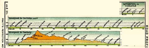 click to enlarge click to enlargePRA1G1.jpg Note the route is via Beetham and Milnthorpe item:- Hampshire Museums : FA2001.138 Image © see bottom of page |
||||||||||||||||||||||||||||||||||
|
|
|||||||||||||||||||||||||||||||||||
| evidence:- | old strip map:- CTC 1911 (Roads) |
||||||||||||||||||||||||||||||||||
| source data:- | Page 16 of Cyclists' Touring Club British Road Book new series vol.6, edited by F
B Sandford, published by Thomas Nelson and Sons, London etc, 1911.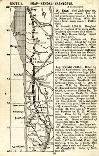 click to enlarge click to enlargeCTC216.jpg Strip road map, route 1, Shap Kendal Carnforth, part of Carlisle to Tarporley, scale about 5 miles to 1 inch. Together with an itinerary and gradient diagram. item:- JandMN : 491.16 Image © see bottom of page |
||||||||||||||||||||||||||||||||||
|
|
|||||||||||||||||||||||||||||||||||
| evidence:- | old strip map:- CTC 1911 (Roads) |
||||||||||||||||||||||||||||||||||
| source data:- | Page 17 of Cyclists' Touring Club British Road Book new series vol.6, edited by F
B Sandford, published by Thomas Nelson and Sons, London etc, 1911.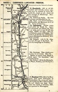 click to enlarge click to enlargeCTC217.jpg Strip road map, route 1, Carnforth Lancaster Preston, part of Carlisle to Tarporley, scale about 5 miles to 1 inch. Together with an itinerary and gradient diagram. item:- JandMN : 491.17 Image © see bottom of page |
||||||||||||||||||||||||||||||||||
|
|
|||||||||||||||||||||||||||||||||||
| evidence:- | old map:- Burrow 1920s |
||||||||||||||||||||||||||||||||||
| source data:- | Road book, On the Road, Dunlop Pictorial Road Plans, volume V,
strip maps with parts in Westmorland, Cumberland etc, irregular
scale about 1.5 miles to 1 inch, by E J Burrow and Co,
Cheltenham, Gloucestershire, 1920s.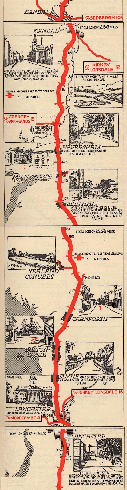 EJB3LtoK.jpg Note the route is via Beetham and Milnthorpe item:- private collection : 17 Image © see bottom of page |
||||||||||||||||||||||||||||||||||
|
|
|||||||||||||||||||||||||||||||||||
| evidence:- | old text:- Burrow 1920s placename:- |
||||||||||||||||||||||||||||||||||
| source data:- | Road book, strip maps with parts in Westmorland, Cumberland etc,
irregular scales about 1.5 miles to 1 inch, by E J Burrow and
Co, Cheltenham, Gloucestershire, 1920s. "... At Lancaster we are at the mouth of the Lune, which must be crossed by Skerton Bridge on leaving the town and soon we are travelling less than two miles from the coast, through Slyne and Bolton-le-Sands, to where the ironworks of Carnforth impose themselves boldly upon the landscape. In another two or three miles we run out of Lancashire into Westmorland." "The Lake District" "And now for the most spectacular part of the journey. For a majority of those who travel this road it will stand, perhaps, as the road to the Lakes rather than as the road to Glasgow. The gateway to the Lake District from the south is Kendal, marked as we approach it by the ruins of Kendal Castle crowning a hill to the right. ..." |
||||||||||||||||||||||||||||||||||
|
|
|||||||||||||||||||||||||||||||||||
| places:- | Lancaster, Lancashire Slyne, Lancashire Carnforth, Lancashire Beetham Burton-in-Kendal alternative route Milnthorpe Levens Hall, Levens Sizergh Castle, Sizergh Helsington Kendal |
||||||||||||||||||||||||||||||||||
|
|
|||||||||||||||||||||||||||||||||||
Lakes Guides menu.