 Old Cumbria Gazetteer
 |
 |
|
| Alum Pot, North Yorkshire | ||
| Alum Pot | ||
| Helln Pot | ||
| Alan Pot | ||
| Allam Pot | ||
| site name:- | Ribblesdale | |
| locality:- | Selside | |
| county:- | North Yorkshire | |
| locality type:- | cave | |
| coordinates:- | SD775756 | |
| 1Km square:- | SD7775 | |
| 10Km square:- | SD77 | |
| SummaryText:- | First direct descent by Boyd Dawkins and others, 1870. | |
| SummaryText:- | Permission: see North Cote, Selside; grade III. | |
| references:- | Brook, A & Brook, D & Davies, G M &Long, M H: 1975: Northern Caves, vol.3 Ingleborough:
Dalesman Books (Clapham, North Yorkshire):: ISBN 0 85206 312 1 |
|
|
|
||
| evidence:- | descriptive text:- West 1778 (11th edn 1821) placename:- Alun Pot placename:- Alumn Pot placename:- Alan Pot |
|
| source data:- | Guide book, A Guide to the Lakes, by Thomas West, published by
William Pennington, Kendal, Cumbria once Westmorland, and in
London, 1778 to 1821. goto source goto sourceTour to the Caves in the West Riding of Yorkshire, late 18th century Page 272:- "..." "... we came to Alun or Alumn-pot, two or three furlongs above the little village of Selside. It is a round steep hole in the limestone rock, about eight or ten yards in diameter, and of a tremendous depth, somewhat resembling Elden-hole, in Derbyshire. We stood for some time on its margin, which is fringed round with shrubs, in silent astonishment, not thinking it safe to venture near enough to its brim to try if we could see to its bottom. The profundity seemed vast and terrible, from the continued hollow gingling noise excited by the stones we tumbled into it. We plummed it to the depth of a hundred and sixty-five feet, forty-three of which were in water, and this is an extra-" goto sourcePage 273:- "[extra]ordinary dry season. As the direction of this hole was not exactly perpendicular, but somewhat sloping, it is very probable we were not quite at the bottom. A subterranean rivulet descends into this terrible hiatus, which caused such a dreadful gloom, from the spray it raised up, as to make us shrink back with horror when we could get a peep into the vast abyss. We were informed, that not long since some animals - an ox and a calf, at different times, had the misfortune to tumble into this dreary pit, being tempted by the untasted herbage to venture too far on its slippery margin. Only a low mound of earth surrounds its brim; for a stone wall would answer no other purpose, than to afford the curious traveller materials to throw in for his amusement. Any advantage arising from the skins and carcases of these animals, was not a sufficient inducement to tempt a neighbouring adventurous youth to be let down by ropes to the bottom of this frightful chasm.- The waters run from its bottom above a mile under ground, and then appear again in the open air below the little village of Selside.- After having excited the several passions of curiosity, dread, and horror, from the negative knowledge we got of the capacity and depth of this huge pot, we went a little higher up the mountain, and came to another hiatus, called Long-churn." goto sourcePage 274:- "... After having rested ourselves a little, we returned to the chasm where we first entered Long-churn, and descending again, pursued the rivulet eastward, along another extensive subterranean passage called Dicken-pot, which slopes and winds by degrees till it enters the ghastly and tremendous Alan-pot. We went an hundred and fifty-seven yards along this 'antre-vast,' till we came to a steep rock full twelve feet perpendicular. Here we stopped - ... There is no doubt but if we had ventured further we might have come to Alan-pot, at least so near as either to have seen the water that stagnates at its bottom, or the light that is admitted into this gaping monster of nature. ..." |
|
|
|
||
| evidence:- | descriptive text:- Otley 1823 (8th edn 1849) placename:- Alum Pot |
|
| source data:- | Guide book, A Concise Description of the English Lakes, the
mountains in their vicinity, and the roads by which they may be
visited, with remarks on the mineralogy and geology of the
district, by Jonathan Otley, published by the author, Keswick,
Cumberland now Cumbria, by J Richardson, London, and by Arthur
Foster, Kirkby Lonsdale, Cumbria, 1823; published 1823-49,
latterly as the Descriptive Guide to the English Lakes. goto source Page 201:- "..." "ALUM POT lies half a mile south-west of the village of Selside, It is a most awful looking abyss, at least 50 yards in circumference, and has been measured to the depth of 165 feet, or 55 yards, 43 feet of which were in water, and that, too, in a very dry season." |
|
|
|
||
| evidence:- | descriptive text:- Balderston c1890 placename:- Alum Pot placename:- Alum Pot Hole |
|
| source data:- | Book, Ingleton, Bygone and Present, by Robert R and Margaret
Balderston, published by Simpkin, Marshall and Co, London, and
by Edmndson and Co, 24 High Street, Skipton, Yorkshire, about
1890. goto source page 53:- "..." "... It [Long Churn] is a cave of engulfment, or one which has to be entered along with the stream that flows underground towards Alum Pot, ..." "Dicken Pot is formed by a branch of the same stream in the higher part of its course, ..." goto sourcepage 54:- "Alum Pot." "About a mile and three-quarters from Long Kin Cave, across the moorland allotments to the north north-east, in a hollow in the scars above Selside, is Alum Pot Hole, into which a stream, called Alum Pot Beck, precipitates itself, in time of flood, as a magnificent fall without break for a great distance, the cataract reaching a depth of about one hundred and seventy-five feet before arriving at the bottom of the shallower portion of the chasm. The shape of this awesome gulf is that of an ellipse very much compressed, its length being about forty yards, with a width of twelve. There is a bridge across the south-eastern end of the abyss, formed from two huge baulks of timber, with thick boards laid across from one to the other, and a fair railing on either hand, but it must be urgently impressed upon visitors to walk as nearly over the baulks as possible, and not in the middle of the boards, and, also, to trust only slightly to the rails, as the lighter portions of the fabric are decidedly time-worn. So many different accounts have been given of Alum Pot that we think it due to ourselves to let these stand side by side with our own. An old writer describes it as being one hundred and fifty feet in girth, with a depth of one hundred and sixty-five feet, forty-three of which were measured through water, that filled the bottom at a time of drought. A recent guide-book gives the depth as supposed to be about three hundred yards - this estimate, we are aware, is a mistake for three hundred feet. A gentleman who formed one of the party that attempted to explore this terrific hole - which exploration was a failure, there being a whirlpool at the bottom at the time - tells us that the depth then estimated was three hundred feet, and that there was some hole below which could not be seen from above; but, for all that, the actual descent does not appear to have been made nearly as far as the point to which our own measure-" goto sourcepage 55:- "[measure]ment extends, which for our part was not in water, whilst no determination whatever of depth can be made with the plummet submerged in a whirlpool, for two hundred feet of line can be carried out ad libitum when once in the rush of water, without any definite knowledge of distance; the only true criterion of the ultimate goal having been reached is the ring, thud, or plash of the plummet, and the decided difference in the tension of the line. Our observations are as follows:- To the south the hole is shallower than at the other end, measuring off the bridge one hundred and eighty-three feet deep, the stony stratum forming the bottom being quite apparent, with a little watery basin here and there. Nearer the middle a large mass of rock spans the cavity, and, if we remember rightly, the plummet caught on it at one hundred and fifty feet, when measuring the deeper gulf just beyond its verge, where the depth proved to be two hundred and thirty-five feet. A second descent of the plummet was made at the northern end, with a second record of two hundred and thirty-five feet, whilst a third, if not a fourth, was made at the intermediate point, the figures two hundred and thirty-five being again the record, without a pool even of water in the bottom. These tests show a uniformity in the basement region, with a level, rocky stratum in that portion of the abyss, which can be only dimly seen from above, owing the propinquity of the rocks, and the peculiar curve which they to some extent assume towards the east. The stream enters at the lowest part of the cliff; another from Long Churn (?) can be heard plashing towards the opposite extreme; whilst trees are abundant around the more lofty margin." |
|
|
|
||
| evidence:- | old map:- Balderston c1890 map placename:- Alum Pot |
|
| source data:- | Map, the hills in the Ingleton area, probably by Robert R
Balderston, engraved by Goodall and Suddick, Leeds, West
Yorkshire, about 1890.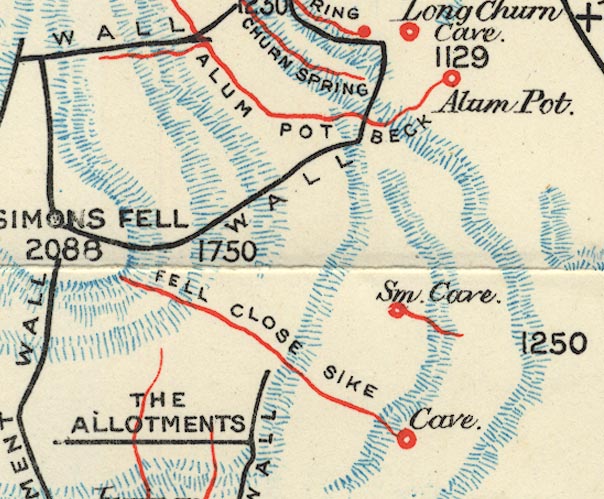 BS1SD77S.jpg "Alum Pot" item:- private collection : 27.1 Image © see bottom of page |
|
|
|
||
Lakes Guides menu.