 Old Cumbria Gazetteer
 |
 |
|
| Banner Rigg, Windermere | ||
| Banner Rigg | ||
| civil parish:- | Windermere (formerly Westmorland) | |
| county:- | Cumbria | |
| locality type:- | hill | |
| coordinates:- | SD42659939 (etc) | |
| 1Km square:- | SD4299 | |
| 10Km square:- | SD49 | |
| altitude:- | 869 feet | |
| altitude:- | 265m | |
|
|
||
| evidence:- | old map:- OS County Series (Wmd 32 8) placename:- Banner Rigg |
|
| source data:- | Maps, County Series maps of Great Britain, scales 6 and 25
inches to 1 mile, published by the Ordnance Survey, Southampton,
Hampshire, from about 1863 to 1948. |
|
|
|
||
| evidence:- | outline view:- Black 1856 (23rd edn 1900) placename:- Haw |
|
| source data:- | Print, lithograph, Outline Views, Windermere - Mountains as seen from the North End
of Belle Isle, Windermere, and Mountains as seen from Biscay How, Bowness, by J Flintoft,
Keswick, Cumberland, engraved by R Mason, Edinburgh, Lothian, about 1900.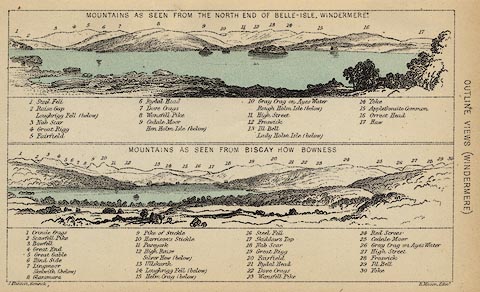 click to enlarge click to enlargeBC08E1.jpg "... 17 Haw ..." item:- JandMN : 37.4 Image © see bottom of page |
|
|
|
||
| evidence:- | just perhaps outline view:- Black 1841 (3rd edn 1846) placename:- Haw |
|
| source data:- | Print, engraving, outline view, Mountains as seen from the North End of Belle Isle,
Windermere, and Mountains as seen from Bisket How, Bowness, by J Flintoft, Keswick,
Cumberland, engraved by R Mason, Edinburgh, about 1844.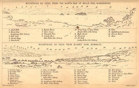 click to enlarge click to enlargeBC02E1.jpg "... 17 Haw ..." item:- JandMN : 32.3 Image © see bottom of page |
|
|
|
||
 Lakes Guides menu.