 Old Cumbria Gazetteer
 |
 |
|
| Barrow Mine, Above Derwent | ||
| Barrow Mine | ||
| Barrow and Uzzicar Lead Mine | ||
| locality:- | Barrow | |
| locality:- | Uzzicar | |
| civil parish:- | Above Derwent (formerly Cumberland) | |
| county:- | Cumbria | |
| locality type:- | lead mine | |
| locality type:- | mine | |
| coordinates:- | NY23372173 (about) | |
| 1Km square:- | NY2321 | |
| 10Km square:- | NY22 | |
| references:- | Adams, John: 1988: Mines of the Lake District Fells: Dalesman Books (Lancaster, Lancashire)::
ISBN 0 85206 931 6 |
|
|
|
||
| evidence:- | old text:- Postlethwaite 1877 (3rd edn 1913) placename:- Barrow Mine item:- Sandy Vein; friable quartz; water wheel; tributer; galena; cerussite; blende; iron pyrites; lead ore; iron ore |
|
| source data:- | Book, Mines and Mining in the English Lake District, by John Postlethwaite, Keswick,
published by W H Moss and Sons, Whitehaven, Cumberland now Cumbria, 1877; published
1877-1913. goto source goto sourcepage 88:- "BARROW MINE." "The Yewthwaite vein crosses the Vale of Newlands diagonally, and passes through a mountain called "Barrow," on the opposite side, where it has been wrought very extensively. A little has been done on the north-western side of the mountain, near the ridge; but on the south-eastern side it has been pierced by numerous levels, from the ridge down to the base, and large quantities of orey ground stoped out between them. Three lines of shallow pits have also been sunk at the base of the mountain, apparently on three parallel branches of the vein, but they cannot have penetrated to any great depth, as it would be impossible to sink far below the bottom of the valley without the aid of machinery, owing to the large quantity of water they would have to contend with." "The Barrow veins, especially one called the "sandy vein," contain large quantities of friable quartz, like coarse brown sugar, so loose and dry that it would frequently run, like the sand in an hour glass, and fill the levels and other workings, and almost defy" goto sourcepage 89:- "all efforts to stop it. Nearly all the levels were driven forward to a blank wall, proving that at the northern part of the mine the vein has been shifted by a fault, but it has not been ascertained whether to the east or the west, nor has the amount of lateral displacement been determined." "The author has reason to believe that no attempt has ever been made to draw plans or sections of the old workings of either the principal vein on the western side, or its numerous ramifications on the eastern side, the greatest part of the excavations having been made by men who worked only where payable ore was to be found, but any visitor who casts his eye over the south-eastern face of the mountain, and along its base, and notes the vast quantity of debris thrown out will be convinced that a great amount of work has been done." "In 1848 Barrow was taken up by the Keswick Mining Co., who continued working it until 1865; but only by a few tributers*during the greater part of that time. About 1851, and a few years later, it was wrought with a little more vigour, and at that time from twelve to sixteen tons of ore were raised per month." "After the dissolution of the Keswick Mining Co., this mine was taken up by Mr. H. K. Spark, who opened one of the lower levels, and continued exploring for some time, but with little or no success." "In the latter part of 1883 the mine was leased to Mr. H. B. Vercoe, who formed a Company called the "Barrow Mining Co." A shaft was sunk at the base of the mountain, to a depth of 40 fathoms, and a 20-horse power engine was erected for the purpose of pumping, drawing, and crushing. Afterwards a very fine water-wheel, 60 feet in diameter, and 75-horse power, was erected for pumping purposes, and the engine relieved of that part of its work. Three sets of levels were driven off north and south from the shaft, namely, at 18, 30 and 40 fathoms from the surface. The 18 and 30 fathom levels have been driven each about 80 fathoms to the north, and about 60 fathoms to the south; but the 40 fathom levels have not been extended more than seven or eight fathoms from the shaft." "Some good deposits of ore were discovered north of the shaft, and a little on the south, and during the five and a half years the mine was worked by this Company about 240 tons of ore were raised." "The ancient excavations in this mine probably gave profitable employment to many generations of miners, extending over a period of between 300 and 400 years. They worked on, in a small way, without machinery, but they extracted all the ore they found, and dressed it by hand in a very efficient manner. In those early" "*Workmen who raise ore on their own account, and pay a certain percentage or "tribute" to the Proprietors." goto sourcepage 90:- "days, the institutions we call "Banks" had not found their way into these remote and sparsely inhabited dales, and the old miners sometimes made their little piles of ore, and hid them in the innermost recesses of the mines. A good deal of the ore found in Barrow Mine occurs in detached solid lumps, of various sizes, embedded in the friable quartz, and these detached lumps of ore were peculiarly adapted for storing up in that way. If some disaster or sudden death befel a man who had a store of that kind hidden away, and who had no one to share his secret, it of course remained hidden until it was discovered by some explorer, perhaps in a future generation. Between the years 1848 and 1865, two such store-houses were unearthed in Barrow Mine. One of these the author is able to describe, although he did not actually see it. The old miners had found a run of ore in driving a level along one of the branches of the vein, high up the mountain, and they sank a shaft to a considerable depth, and made a store-house at the bottom of it. Apparently a fall of rock had blocked the top of the shaft, and so far down, and for some reason it had not been cleared by the old men. In 1864 some workmen were driving a lower level along the same branch of the vein, when they broke into the old shaft, about half-way down. On looking up they saw the huge fragments of rock which had blocked the upper part of the shaft, firmly wedged together, and on descending to the bottom, found the store of ore, ready to be drawn up and sent right off to market." "The value of the ore was about L35, but it is probable that when it was deposited there, its value would be three or four times that amount." "Barrow Mine, being on the same vein as Yewthwaite, yields the same ores, namely, Galena, Cerussite, Blende, and Iron Pyrites." |
|
|
|
||
| evidence:- | old map:- Postlethwaite 1877 (3rd edn 1913) placename:- Barrow Mine |
|
| source data:- | Map, uncoloured engraving, Map of the Lake District Mining Field, Westmorland, Cumberland,
Lancashire, scale about 5 miles to 1 inch, by John Postlethwaite, published by W H
Moss and Sons, 13 Lowther Street, Whitehaven, Cumberland, 1877 edn 1913.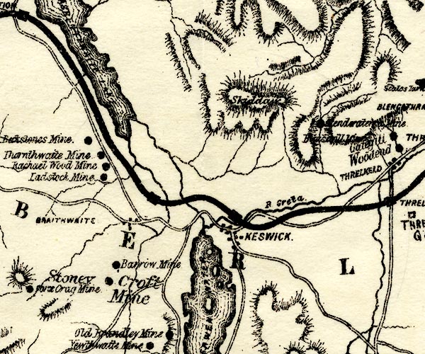 PST2NY22.jpg "Barrow Mine" mine symbol item:- JandMN : 162.2 Image © see bottom of page |
|
|
|
||
| notes:- |
This extensive and very old lead mine was described in the 1680s when it was already
old. It closed 1910. Several minerals were extracted from the Barrow Lode: galena,
lead sulphide, PbS; baryte, barium sulphate, BaSO4; cerussite, white lead, lead carbonate,
PbCO3; and aragonite, calcareous spar, calcium carbonate, CaCO3. There is some silver,
and some other minerals: pyromorphite, iron pyrite, and quartz. The mine shafts were
as deep as 700 feet though early mining in bell pits were dug near Uzzicar farm. In
the mid 17th century there was mining on the west face of Barrow Hill. |
|
| : 2015 (?): Mines in Cumbria: Cumbria RIGS |
||
|
|
||
Lakes Guides menu.