 Old Cumbria Gazetteer
 |
 |
|
| Blaithwaite House, Waverton | ||
| Blaithwaite House | ||
| locality:- | Blaithwaite | |
| civil parish:- | Waverton (formerly Cumberland) | |
| county:- | Cumbria | |
| locality type:- | buildings | |
| coordinates:- | NY21334474 | |
| 1Km square:- | NY2144 | |
| 10Km square:- | NY24 | |
|
|
||
| evidence:- | old map:- OS County Series (Cmd 28 16) placename:- Blaithwaite House |
|
| source data:- | Maps, County Series maps of Great Britain, scales 6 and 25
inches to 1 mile, published by the Ordnance Survey, Southampton,
Hampshire, from about 1863 to 1948. |
|
|
|
||
| evidence:- | probably old map:- Donald 1774 (Cmd) placename:- Blaithwaite |
|
| source data:- | Map, hand coloured engraving, 3x2 sheets, The County of Cumberland, scale about 1
inch to 1 mile, by Thomas Donald, engraved and published by Joseph Hodskinson, 29
Arundel Street, Strand, London, 1774.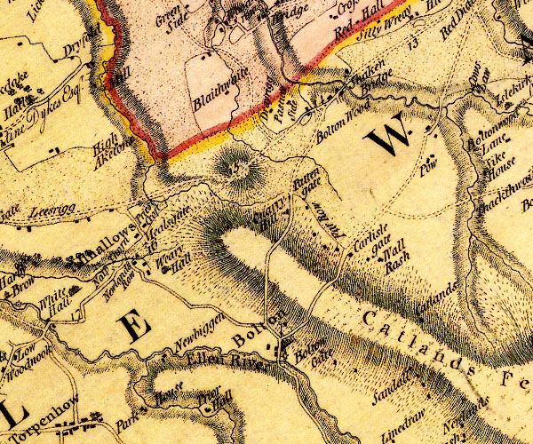 D4NY24SW.jpg "Blaithwaite" block or blocks, labelled in lowercase; a hamlet or just a house item:- Carlisle Library : Map 2 Image © Carlisle Library |
|
|
|
||
| evidence:- | database:- Listed Buildings 2010 placename:- Blaithwaite House item:- date stone (1894) |
|
| source data:- | courtesy of English Heritage "BLAITHWAITE HOUSE / / / SILLOTH ON SOLWAY / ALLERDALE / CUMBRIA / II / 72002 / NY2133244749" |
|
|
|
||
| evidence:- | database:- Listed Buildings 2010 |
|
| source data:- | courtesy of English Heritage "STABLE BLOCK, DOVECOTE AND FORMER BARN TO SOUTH OF BLAITHWAITE HOUSE / / / WAVERTON / ALLERDALE / CUMBRIA / II / 72003 / NY2130244719" |
|
|
|
||
| evidence:- | database:- Listed Buildings 2010 |
|
| source data:- | courtesy of English Heritage "GAZEBO NORTH OF BLAITHWAITE HOUSE / / / WAVERTON / ALLERDALE / CUMBRIA / II / 72004 / NY2129444864" |
|
|
|
||
 Lakes Guides menu.