 Old Cumbria Gazetteer
 |
 |
|
| Blake Fell, Lamplugh | ||
| Blake Fell | ||
| civil parish:- | Lamplugh (formerly Cumberland) | |
| civil parish:- | Loweswater (formerly Cumberland) | |
| county:- | Cumbria | |
| locality type:- | hill | |
| locality type:- | fell | |
| locality type:- | boundary feature | |
| locality type:- | parish boundary feature | |
| coordinates:- | NY11061970 | |
| 1Km square:- | NY1119 | |
| 10Km square:- | NY11 | |
| altitude:- | 1878 feet | |
| altitude:- | 572m | |
|
|
||
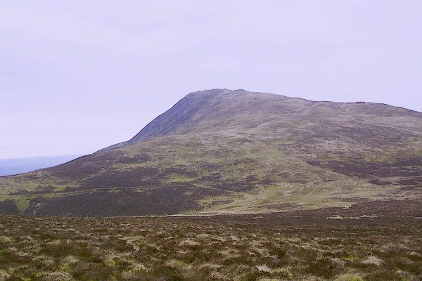 BQJ24.jpg (taken 1.4.2009) |
||
|
|
||
| evidence:- | old map:- OS County Series (Cmd 62 16) placename:- Blake Fell |
|
| source data:- | Maps, County Series maps of Great Britain, scales 6 and 25
inches to 1 mile, published by the Ordnance Survey, Southampton,
Hampshire, from about 1863 to 1948. |
|
|
|
||
| evidence:- | old map:- Gents Mag 1751 placename:- Blake Fell |
|
| source data:- | Map, uncoloured engraving, Map of the Black Lead Mines in
Cumberland, and area, scale about 2 miles to 1 inch, by George
Smith, published in the Gentleman's Magazine, 1751.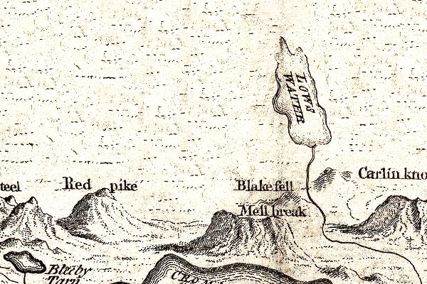 GM1302.jpg "Blake Fell" knobbly hillocks; mountainslock, knobbly hillocks; mountainsls item:- JandMN : 114 Image © see bottom of page |
|
|
|
||
| evidence:- | old map:- Donald 1774 (Cmd) placename:- Blake Fell |
|
| source data:- | Map, hand coloured engraving, 3x2 sheets, The County of Cumberland, scale about 1
inch to 1 mile, by Thomas Donald, engraved and published by Joseph Hodskinson, 29
Arundel Street, Strand, London, 1774.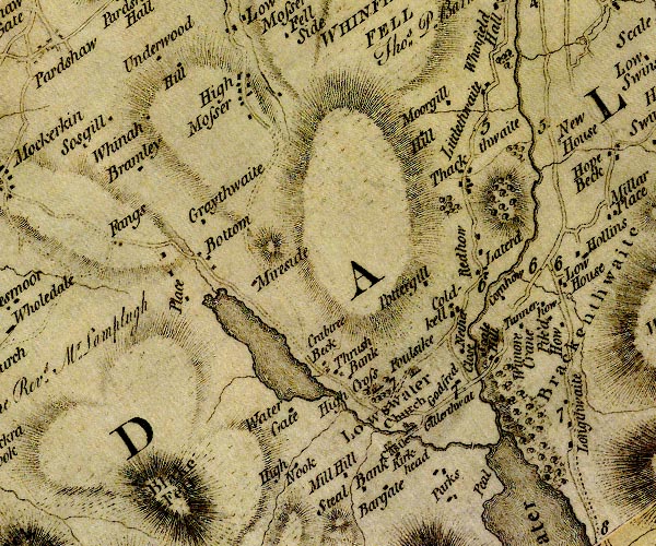 D4NY12SW.jpg "Blake Fell" 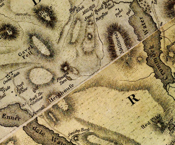 D4NY11NW.jpg "Blake Fell" hill hachuring; a hill or mountain item:- Carlisle Library : Map 2 Images © Carlisle Library |
|
|
|
||
| evidence:- | old map:- Otley 1818 placename:- Blake fell |
|
| source data:- | Map, uncoloured engraving, The District of the Lakes,
Cumberland, Westmorland, and Lancashire, scale about 4 miles to
1 inch, by Jonathan Otley, 1818, engraved by J and G Menzies,
Edinburgh, Scotland, published by Jonathan Otley, Keswick,
Cumberland, et al, 1833.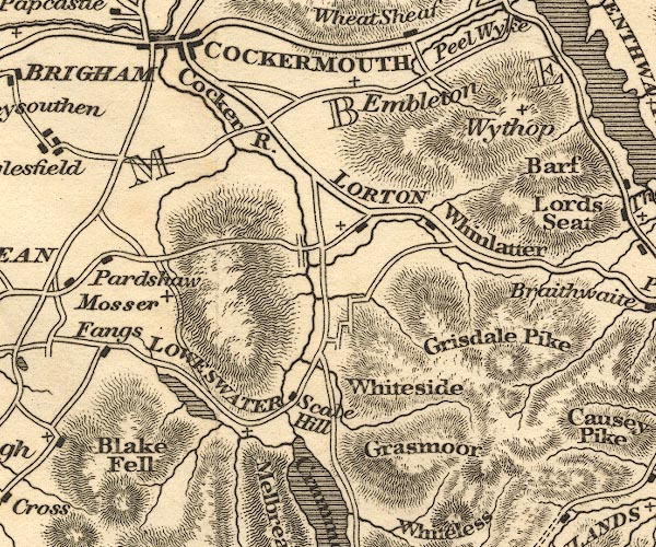 OT02NY12.jpg item:- JandMN : 48.1 Image © see bottom of page |
|
|
|
||
| evidence:- | outline view:- Otley 1823 (8th edn 1849) placename:- Blake Fell |
|
| source data:- | Engraving, outline view of mountains, A Group of Mountains seen from Helvellyn, looking
towards the South West, drawn by T Binns, engraved by O Jewitt, opposite p.50 of A
Descriptive Guide of the English Lakes, by Jonathan Otley, 8th edition, 1849.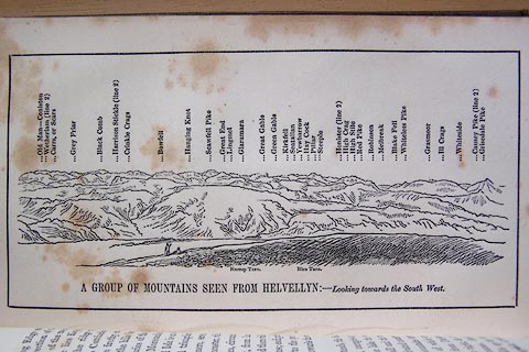 click to enlarge click to enlargeO80E17.jpg item:- Armitt Library : A1180.18 Image © see bottom of page |
|
|
|
||
| evidence:- | outline view:- Otley 1823 (4th edn 1830) placename:- Blake Fell |
|
| source data:- | Print, engraving, outline view, Some of the Western Mountains as seen from Helvellyn,
published by Jonathan Otley, Keswick, Cumberland et al, 1830.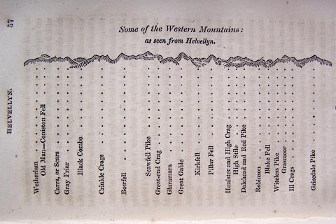 click to enlarge click to enlargeO75E02.jpg p.57 in A Concise Description of the English Lakes, by Jonathan Otley, 4th edition, 1830. "Some of the Western Mountains: / as seen from Helvellyn." "Wetherlam / Old Man - Coniston Fell / Carrs, or Scars / Gray Friar / Black Combe / Crinkle Crags / Bowfell / Scawfell Pike / Great-end Crag / Glaramara / Great Gable / Kirkfell / Pillar Fell / Honister and High Crag / High Stile / Dalehead and Red Pike / Robinson / Blake Fell / Witeless Pike / Grasmoor / Ill Crags / Grisedale Pike" item:- Armitt Library : A1175.3 Image © see bottom of page |
|
|
|
||
| evidence:- | outline view:- Otley 1823 (5th edn 1834) |
|
| source data:- | Print, woodcut outline view, A Group of Mountains, seen from
Helvellyn, by Jonathan Otley, Keswick, Cumberland, 1830.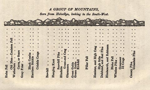 click to enlarge click to enlargeOT2E09.jpg Printed on p.63 of A Concise Description of the English Lakes, by Jonathan Otley, 5th edition, 1834. "A GROUP OF MOUNTAINS, Seen from Helvellyn, looking to the South-West." "Holm Fell / Old Man - Coniston Fell / Wetherlam / Carrs, or Scars / Gray Friar / Black Combe / Harrison Stickle / Crinkle Crags / Bowfell / Hanging Knot / Scawfell Pike / Hindside / Great-end Crag / Glaramara / Great Gable / Green Gable / Kirkfell / Pillar Fell / Honister, and High Crag / High Stile / Dalehead, and Red Pike / Hindscarth, and Robinson / Blake Fell / Witeless Pike / Grasmoor / Ill Crags / Causey Pike / Grisedale Pike" item:- JandMN : 48.10 Image © see bottom of page |
|
|
|
||
| evidence:- | old text:- Martineau 1855 item:- storm; weather |
|
| source data:- | Guide book, A Complete Guide to the English Lakes, by Harriet
Martineau, published by John Garnett, Windermere, Westmorland,
and by Whittaker and Co, London, 1855; published 1855-76. goto source goto sourcePage 127:- "..." "We [author] had once an adventure in this neighbourhood, the moral of which is, the comfort and security of having a guide. We wanted to cross Blake Fell to Loweswater. The distance to Scale Hill Inn was only six miles; the time summer; and the track well marked on map and mountain. If there ever was a case in which a guide might be thought unnecessary, it was this: but two out of the party were young strangers; and the third would not assume the charge of them. The heat was excessive that day; so we lagged behind the guide, on the ascent, though he carried knapsack and baskets. He was a quiet-looking elderly mountaineer, who appeared to walk very slowly; but his progress was great, compared with ours, from the uniformity and continuity of his pace. In the worst part of the walk, we tried the effect of following close behind him, and putting our feet in his tracks; and we were surprised" goto sourcePage 128:- "to find with what ease and rapidity we got on. At first we stopped repeatedly, to sit down and drink from the streams that crossed the track, or flowed beside it: and during those halts, we observed that the blackness which had for some time been appearing in the west, now completely shrouded the sea. Next, we remarked that while the wind still blew in our faces,- that is, from the north-east,- the mass of western clouds was evidently climbing the sky. The guide quietly observed that there would be rain by and by. Next, when we were in the middle of the wide fell, and we saw how puzzling the network of swampy paths must be at all times, we pointed out to one another how the light fleeces of cloud below the black mass swept round in a circle, following each other like streams in an eddy. Soon, the dark mass came driving up at such a rate that it was clear we should not finish our walk in good weather. The dense mist was presently upon us. On looking behind, to watch its rate of advance, we saw a few flashes of lightning burst from it. The thunder had for some time been growling afar, almost incessantly. The moment before the explosion of the storm was as like a dream as a waking state can be. We were walking on wild ground, now ascending, now descending; a deep tarn (Floutern Tarn) on our right hand, our feet treading on slippery rushes, or still more slippery grass: the air was dark, as during an eclipse; and heavy mists drove past from behind, just at the level of our heads, and sinking every moment; while before us, and far far below us - down as in a different world - lay Buttermere and the neighbouring vales" goto sourcePage 129:- "sleeping in the calmest sunshine. The contrast was singular - of that warm picture, with its yellow lights and soft blue shadows, with the turbulence and chill and gloom of the station from which we viewed it. We had but a moment to look at it; for not only did the clouds sink before our eyes, but the wind scudded round to the opposite point of the compass, throwing one after another of us flat as it passed. Within a few minutes, one of us had six falls, from the force of the wind, and the treachery of the ground,- now, in a trice, a medley of small streams. It was impossible to stop the guide, for a moment's breath. In the roar of the blast, and crash of the thunder, and pelt of the hail, one might as well have spoken to the elements: so it was necessary for us all to keep up our pace, that he might not stride away from us entirely. Through stumblings and slidings innumerable, we did this,- the lightning playing about our faces the while, like a will-o'-the-wisp on the face of a bog. The hail and rain had drenched us to the skin in three minutes. The first hailstones reached the skin. They were driven in at every opening of our clothes; they cut our necks behind, and filled our shoes. Our hats and bonnets were immediately soaked through, and every body's hair wringing wet. The thunder seemed to roll on our very skulls. in this weather we went plunging on for four miles, through spungy (sic) bogs, turbid streams, whose bridges of stones were hidden in the rushing waters; or by narrow pathways, each one of which was converted by the storm into an impetuous brook. When we had descended into a region where we could hear ourselves speak, we congratulated one another on our prudence" goto sourcePage 130:- "in having engaged a guide. Without him, how should we have known the path from the brook, or have guessed where we might ford the streams, when the bridges were out of sight? Two horses, we afterwards heard, were killed on the same fell in that storm: and we should never have come down, we were persuaded, if we had been left to wander by ourselves." |
|
|
|
||
| evidence:- | outline view:- Black 1856 placename:- Blake Fell |
|
| source data:- | Print, lithograph, Outline Views, Buttermere - Mountains as seen from the Knots near
the Hotel at Buttermere, and Mountains as seen at the Seat in Lanthwaite Wood, Scale
Hill, by J Flintoft, Keswick, Cumberland, engraved by R Mason, Edinburgh, Lothian,
about 1900.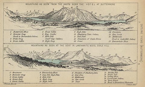 click to enlarge click to enlargeBC08E5.jpg "... 17 Blake Fell ..." item:- JandMN : 37.19 Image © see bottom of page |
|
|
|
||
| evidence:- | outline view:- Black 1841 (3rd edn 1846) placename:- Blake Fell |
|
| source data:- | Print, engraving, outline view, Mountains as seen from The Knots near the Victoria
at Buttermere, and Mountains as seen at the Seat in Lanthwaite Wood, Scale Hill, by
J Flintoft, Keswick, Cumberland, engraved by R Mason, Edinburgh, Lothian, about 1846.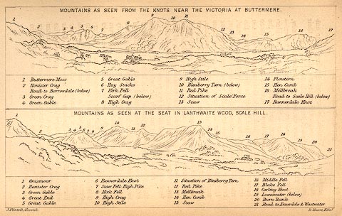 click to enlarge click to enlargeBC02E7.jpg "... 17 Blake Fell ..." item:- JandMN : 32.11 Image © see bottom of page |
|
|
|
||
| evidence:- | old print:- Rose 1832-35 (vol.2 no.13) placename:- Blake Fell |
|
| source data:- | Print, engraving, Loweswater, from Water End, Cumberland, by Thomas Allom, engraved
by W Floyd, 1833.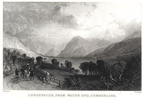 click to enlarge click to enlargePR0402.jpg The text description of the view it 'includes the mountains of Blake Fell, Mellbreak, and Red Pike.' Vol.2 no.13 in Westmorland, Cumberland, Durham and Northumberland Illustrated, with descriptions by Thomas Rose, published by H Fisher, R Fisher, and P Jackson, Newgate, London, about 1835. item:- Dove Cottage : 2008.107.395 Image © see bottom of page |
|
|
|
||
Lakes Guides menu.