 Old Cumbria Gazetteer
 |
 |
|
| Bull Pot of the Witches, Casterton | ||
| Bull Pot of the Witches | ||
| site name:- | Bull Pot Farm | |
| locality:- | Casterton Fell | |
| civil parish:- | Casterton (formerly Westmorland) | |
| county:- | Cumbria | |
| locality type:- | cave | |
| locality type:- | pothole | |
| coordinates:- | SD66238131 (?) | |
| 1Km square:- | SD6681 | |
| 10Km square:- | SD68 | |
| altitude:- | 960 feet | |
| altitude:- | 293m | |
| SummaryText:- | Explored by Yorkshire Ramblers Club; further by British Speleological Association 1966 and 1968; and Red Rose Cave and Pothole Club, 1969. | |
| SummaryText:- | Grade III. | |
| references:- | Balderston c1890 Brook, D & Davies, G & Long, M H &Sutcliffe, J R: 1975: Northern Caves, vol.4 Whernside and Gragareth: Dalesman Books:: ISBN 0 85206 259 1 |
|
|
|
||
| evidence:- | descriptive text:- Balderston c1890 placename:- Bull Pot of the Witches placename:- Bull Pot |
|
| source data:- | Book, Ingleton, Bygone and Present, by Robert R and Margaret
Balderston, published by Simpkin, Marshall and Co, London, and
by Edmndson and Co, 24 High Street, Skipton, Yorkshire, about
1890. goto source goto sourcepage 74:- "..." "Bull Pot of the Witches." "Following the next wall to the south west from Gavel Pot downwards, so as to reach the Easegill Beck, where are the Witches' Caves, the Kirk, and other places already described, and ascending a small stream that is the direct continuation of the Leck Beck, and does not bend away like Easegill, a walk of about three-quarters of a mile along this little valley, brings the tourist to Bull Pot in the very centre of the hollow, a trifle below the last farm house in this direction, and only a field's breadth away from the road running along Casterton Fell. Bull Pot is a dreadful hole, foetid with the dead carcases of sheep and lambs, and whitened with skeletons. A vast cave-like mouth is to be seen in the base of its north western side; a waterfall precipitates itself downwards to an extent of fifty-eight feet, though when the water is low its principal leap is diminished to forty-five with a secondary cascade below. The rock to the south is fifty-four feet high; that on the west, though not sheer at the top, is eighty-five feet; whilst the hole itself measured round its neck of entrance is about seventy-seven yards." |
|
|
|
||
| evidence:- | probably old map:- Balderston c1890 map placename:- Witches Cave |
|
| source data:- | Map, the hills in the Ingleton area, probably by Robert R
Balderston, engraved by Goodall and Suddick, Leeds, West
Yorkshire, about 1890.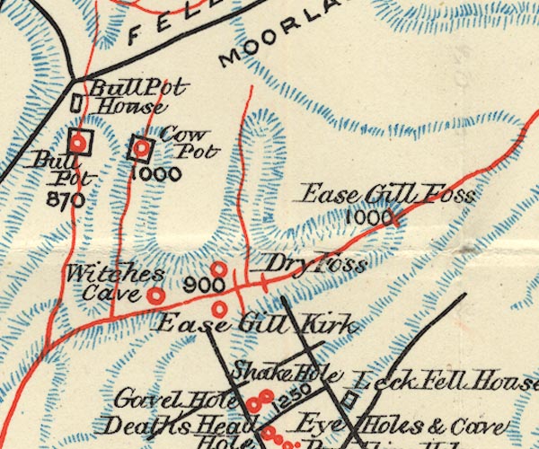 BS1SD68Q.jpg "Witches Cave" item:- private collection : 27.1 Image © see bottom of page |
|
|
|
||
| links to:- | Lancaster Hole, Casterton |
|
|
|
||
Lakes Guides menu.