 Old Cumbria Gazetteer
 |
 |
|
| Bull Pot, North Yorkshire | ||
| Bull Pot | ||
| county:- | North Yorkshire | |
| locality type:- | cave | |
| coordinates:- | SD702787 | |
| 1Km square:- | SD7078 | |
| 10Km square:- | SD77 | |
| altitude:- | 1175 feet | |
| altitude:- | 358m | |
| SummaryText:- | Explored in 1899; by Yorkshire Ramblers Club, 1934; and by Craven POthole Club, 1948. | |
| SummaryText:- | Grade III; permission from Wetsgate, Westhouse. | |
| references:- | Brook, D & Davies, G & Long, M H &Sutcliffe, J R: 1975: Northern Caves, vol.4 Whernside
and Gragareth: Dalesman Books:: ISBN 0 85206 259 1 |
|
|
|
||
| evidence:- | descriptive text:- Balderston c1890 placename:- Bull Pot |
|
| source data:- | Book, Ingleton, Bygone and Present, by Robert R and Margaret
Balderston, published by Simpkin, Marshall and Co, London, and
by Edmndson and Co, 24 High Street, Skipton, Yorkshire, about
1890. goto source goto sourcepage 64:- "..." "Bull Pot." "Still further to the north the next stream sinks just before reaching Bull Pot, which is roofed in by huge masses of rock, through the chinks, of which the depth is only found to be twenty-three feet. A large 'sink hole' is to be seen just above. A second portion of Bull Pot, which is on the high side of the rock, is similarly closed, and this is forty-seven feet deep, having a waterfall in it, and a cave connected with the chasm." |
|
|
|
||
| evidence:- | old map:- Balderston c1890 map placename:- Bull Pot |
|
| source data:- | Map, the hills in the Ingleton area, probably by Robert R
Balderston, engraved by Goodall and Suddick, Leeds, West
Yorkshire, about 1890.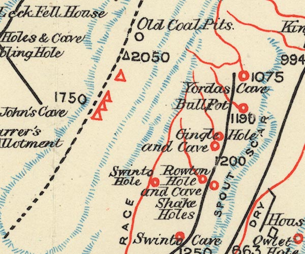 BS1SD67Z.jpg "Bull Pot" item:- private collection : 27.1 Image © see bottom of page |
|
|
|
||
Lakes Guides menu.