 Old Cumbria Gazetteer
 |
 |
|
| Cellar Hole, North Yorkshire | ||
| Cellar Hole | ||
| site name:- | Whernside | |
| site name:- | Braida Garth Scar | |
| county:- | North Yorkshire | |
| locality type:- | pothole | |
| locality type:- | cave | |
| coordinates:- | SD707774 | |
| 1Km square:- | SD7077 | |
| 10Km square:- | SD77 | |
| altitude:- | 1220 feet | |
| altitude:- | 372m | |
| SummaryText:- | Grade I; permission Braida Garth Farm. | |
| references:- | Balderston c1890 map Brook, D & Davies, G & Long, M H &Sutcliffe, J R: 1975: Northern Caves, vol.4 Whernside and Gragareth: Dalesman Books:: ISBN 0 85206 259 1 |
|
|
|
||
| evidence:- | descriptive text:- Balderston c1890 placename:- Cellar Hole |
|
| source data:- | Book, Ingleton, Bygone and Present, by Robert R and Margaret
Balderston, published by Simpkin, Marshall and Co, London, and
by Edmndson and Co, 24 High Street, Skipton, Yorkshire, about
1890. goto source goto sourcepage 78:- "..." "On Braidey Garth Scar, opposite the house of the same name, lying in the valley below, are several holes of no great depth; ..." goto sourcepage 79:- "..." "Cellar Hole." "... a hole which can be entered on one side and has a cellar-like chamber below, with total vertical depth of twenty-eight feet. In entering the cellar a small shower-bath has to be penetrated." |
|
|
|
||
| evidence:- | old map:- Balderston c1890 map placename:- Cellarhole |
|
| source data:- | Map, the hills in the Ingleton area, probably by Robert R
Balderston, engraved by Goodall and Suddick, Leeds, West
Yorkshire, about 1890.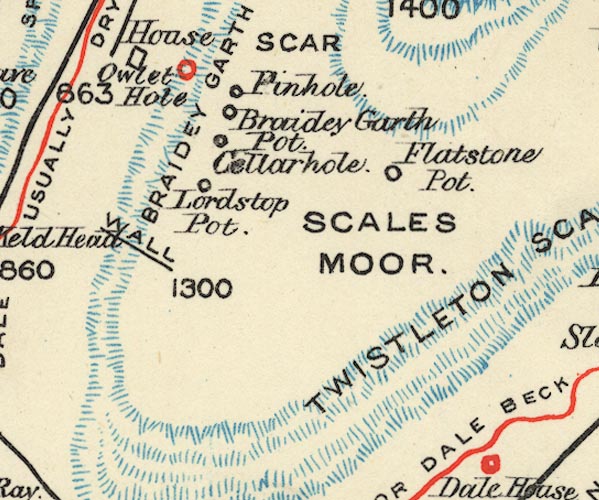 BS1SD77D.jpg "Cellarhole" item:- private collection : 27.1 Image © see bottom of page |
|
|
|
||
Lakes Guides menu.