 Old Cumbria Gazetteer
 |
 |
|
| Chapel Crags, Buttermere | ||
| Chapel Crags | ||
| civil parish:- | Buttermere (formerly Cumberland) | |
| county:- | Cumbria | |
| locality type:- | rocks | |
| coordinates:- | NY163150 | |
| 1Km square:- | NY1615 | |
| 10Km square:- | NY11 | |
|
|
||
| evidence:- | probably outline view:- Martineau 1855 placename:- Bleaberry Crag |
|
| source data:- | Print, engraving, outline view, Mountains seen from Lanthwaite Wood Crummock Water,
drawn by L Aspland, engraved by W Banks, Edinburgh, published by John Garnett, Windermere,
Westmorland, and by Whittaker and Co, London, 1855.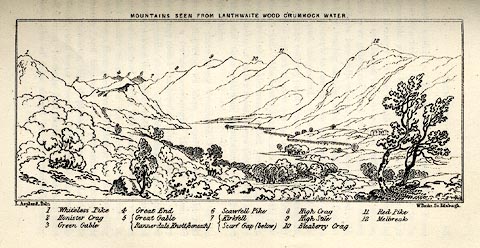 click to enlarge click to enlargeMNU113.jpg Opposite p.84 in A Complete Guide to the English Lakes, by Harriet Martineau. The view is captioned, numbers refering to mountains in the image - 1 Whiteless Pike, 2 Honister Crag, 3 Green Gable, 4 Great End, 5 Great Gable / Rannerdale Knott (beneath), 6 Scawfell Pike, 7 Kirkfell / Scarf Gap (below), 8 High Crag, 9 High Stile, 10 Bleaberry Crag, 11 Red Pike, 12 Melbreak. printed at top:- "MOUNTAINS SEEN FROM LANTHWAITE WOOD CRUMMOCK WATER." printed at bottom left, right:- "L Aspland Delt. / W Banks Sc Edinr." item:- Armitt Library : A1159.13 Image © see bottom of page |
|
|
|
||
 Lakes Guides menu.