 Old Cumbria Gazetteer
 |
 |
|
| Christianbury Crag, Bewcastle | ||
| Christianbury Crag | ||
| locality:- | Black Knowe | |
| locality:- | Blacklyne Common | |
| civil parish:- | Bewcastle (formerly Cumberland) | |
| county:- | Cumbria | |
| locality type:- | hill | |
| coordinates:- | NY57768228 (etc) | |
| 1Km square:- | NY5782 | |
| 10Km square:- | NY58 | |
| altitude:- | 1598 feet | |
| altitude:- | 487m | |
|
|
||
| evidence:- | old map:- OS County Series (Cmd 4 3) placename:- Christianbury Crag |
|
| source data:- | Maps, County Series maps of Great Britain, scales 6 and 25
inches to 1 mile, published by the Ordnance Survey, Southampton,
Hampshire, from about 1863 to 1948. |
|
|
|
||
| evidence:- | old map:- Saxton 1579 placename:- Cristenbury Cragg |
|
| source data:- | Map, hand coloured engraving, Westmorlandiae et Cumberlandiae Comitatus ie Westmorland
and Cumberland, scale about 5 miles to 1 inch, by Christopher Saxton, London, engraved
by Augustinus Ryther, 1576, published 1579-1645.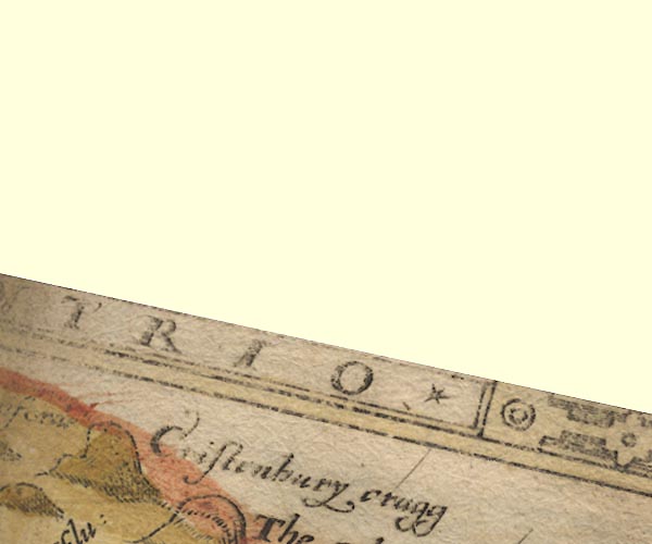 Sax9NY68.jpg "Cristenbury cragg" On the county boundary. item:- private collection : 2 Image © see bottom of page |
|
|
|
||
| evidence:- | old map:- Mercator 1595 (edn?) placename:- Chisteubury Crag |
|
| source data:- | Map, hand coloured engraving, Northumbria, Cumberlandia, et
Dunelmensis Episcopatus, ie Northumberland, Cumberland and
Durham etc, scale about 6.5 miles to 1 inch, by Gerard Mercator,
Duisberg, Germany, about 1595. MER8CumA.jpg "Chisteubury crag" hillock, shaded on east; hill or mountain, on county boundary with Northumberland item:- JandMN : 169 Image © see bottom of page |
|
|
|
||
| evidence:- | old map:- Speed 1611 (Cmd) placename:- Cristenbury Cragg |
|
| source data:- | Map, hand coloured engraving, Cumberland and the Ancient Citie
Carlile Described, scale about 4 miles to 1 inch, by John Speed,
1610, published by J Sudbury and George Humble, Popes Head
Alley, London, 1611-12.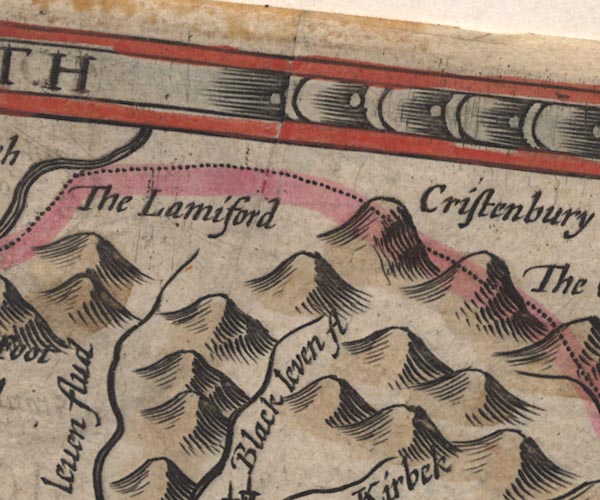 SP11NY58.jpg "Cristenbury Cragg" hillock; on the border item:- private collection : 16 Image © see bottom of page |
|
|
|
||
| evidence:- | old map:- Jansson 1646 placename:- Cristen Bury Cragg |
|
| source data:- | Map, hand coloured engraving, Cumbria and Westmoria, ie
Cumberland and Westmorland, scale about 3.5 miles to 1 inch, by
John Jansson, Amsterdam, Netherlands, 1646.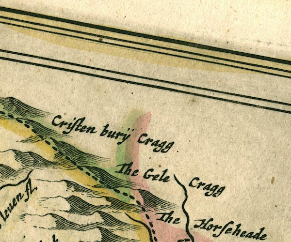 JAN3NY68.jpg "Cristen burÿCragg" Hillock, on county boundary. item:- JandMN : 88 Image © see bottom of page |
|
|
|
||
| evidence:- | old text:- Gents Mag placename:- Christenbury Crags |
|
| source data:- | Print, uncoloured engraving, Christenbury Crags ie Christianbury
Crag, Bewcastle, Cumberland, published by the Gentleman's
Magazine, 1754. goto source goto sourceGentleman's Magazine 1754 opp p.505 Print, uncoloured engraving, Christenbury Crags ie Christianbury Crag, Bewcastle, Cumberland, published by the Gentleman's Magazine, 1754. 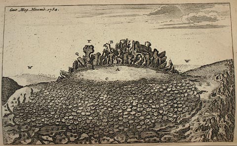 click to enlarge click to enlargePR0756.jpg Size: wxh = 21x12cm. item:- Armitt Library : Gents Mag 1754.2 Image © see bottom of page |
|
|
|
||
| evidence:- | old text:- Gents Mag 1750 item:- guide |
|
| source data:- | goto source Gentleman's Magazine 1754 p.505 "Mr URBAN," "AS you frequently entertain your readers with topographical curiosities, I send you a view and description of a natural rock in Cumberland, called Christen-bury Craiggs. *" "The rock is situated at the top of a mountain, very difficult of access, at which I had often looked through my telescope from a place three and twenty miles distant. The view at length so much excited my curiosity, that I determined to gratify it by a nearer examination; however, as it was early in the spring when I first formed this resolution, and as the ways are scarce passable, even in summer, I waited till the beginning of August, and then set out on my expedition." "I took a guide with me to Beu-Castle, a parish on the northward extremity of Cumberland, in which there is neither town nor village, but a few wretched huts only, which are widely scattered in a desolate country. After a journey of 20 miles, sometimes wading an hour together in water up to the horses girts, though the bottom was tolerably sound, we came to the church. At a small distance I discovered a hedge alehouse, which I knew must serve me for an inn, but when I entered it I was not more disgusted with the dirt and darkness of the room into which I was introduced, the floor of bare earth, and the bed less eligible than clean straw, than I was with the noisy mirth of some boors who had been drinking till the were drunk. However, as I knew it was bootless to complain, I appeared, as well as I could, to be content, that I might not displease my host. The clergyman, indeed, was so obliging as to offer me his room at the parsonage, but as I was unwilling to give trouble, I declined it." "In the evening I acquainted mine host with the intent of my journey, and at my request he procured me another guide, who undertook to conduct me up the mountain to the craiggs. When I rose at four o'clock the next morning, I found him ready. The weather was extremely bright and serene, which greatly favoured my purpose, and after we had proceeded about two miles, we came to a place where there were a few more hovels, called the Flat. After some talk with my guide, I discovered that he was very diffident of the success of our expedition, and of his own ability to procure me safe conduct; and therefore, as we were now in sight of the precipices, I hired a boy that kept sheep upon them to walk with us, at least as far as we could use our horses. By his direction we came into an hollow, through which the river Line runs, among innumerable precipices. In this hollow we were obliged often to cross the water to avoid the falls, and going sometimes on one side, and sometimes on the other, we made about a mile of winding way, and at length came into a kind of plain," "*Bury, in the Saxon language, signifies mansion, or mannor, and perhaps the converts to christianity in the north might assemble here to be undiscovered. - Hence the name Christen-bury." |
|
|
|
||
| evidence:- | old text:- Gents Mag 1750 |
|
| source data:- | goto source Gentleman's Magazine 1754 p.506 "one side of which was bounded by by the declivity of the mountain, which we then began to ascend; soon after we had reached that part which was level with the base of the craigs, we found ourselves environed with a syrtes, which, as Milton says, was neither sea nor good dry land; here we were obliged to dismount, and having tied our horses by the bridles, we proceeded on foot: To tie them was, indeed, an unnecessary precaution, for the poor creatures, by a natural instinctive sagacity, were as sensible of their danger as we, and stood motionless where we left them. We now walked above a mile and a half over a tract of ground full of holes filled with boggy substance, which in this country is called a moss; we were here in perpetual terror lest it should give way under our feet, or lest some cloud, being stopped by the rocks, should bury us in a fog, and not only disappoint my curiosity, but prevent the recovery of our horses. However, we still went forward, and came to a place that was covered with moss of another kind. This lay above the ground in little heaps, about a foot over, called hassocks, which were full of holes, like an honey comb; the long irregular strides which we were obliged to take, to avoid these hassocks, made this part of my journey extreamly fatiguing. When we came within about a quarter of a mile of the base of the rock, we entered all on a sudden upon the finest grass plat that nature can produce; the ascent over this green is very gradual, and it has the appearance of a fine artifical slope. The rocks, upon a near view, appear very rude and romantic; they are broken by innumerable fissures that go quite from top to bottom in a perpendicular direction; most of them are from 10 to 15 yards high; it is not difficult to walk on the top of them, nor in many places to step from one to another; some of them, however, project considerable over the side of the mountain, and upon these it would be dangerous to stand; they cover about three acres of ground, and bear some resemblance to Stone Henge, particularly in the difficulty of numbering them, which I attempted several times, but coculd never produce tha same sum. To the caves among these rocks the moss troopers formerly retreated for security, and of late years on Micklehow, and a favourite mistress, took up their abode here for two or three seasons." "It has at present no inhabitants but wild cats, of which there are many, the largest I ever saw." "In our descent, notwithstanding the skill of the guides, we came a full mile west of our horses, which we at last found by the help of my compass; they stood trembling by one another, and had not strirred a step either in search of food or freedom; we led them down the brow, and thus ended the adventure of Christenbury Craig, which at a distance has all the appearance of one of those enchanted castles that are described in the heroic romances of the middle ages." "The mountain is on the skirts of Northumberland, and the rocks are upon its summit. In the calmest day there is a surprizing draught of bleak air into Northumberland wastes, which are the most shocking desarts that I ever saw in Britain." "If the rottenness of the soil on which these rocks stand be considered, perhaps it will not be thought an improbable conjecture that the whole summit of the mountain was once of the same height with the rocks, but that the wind and rains having by degrees washed and driven the softer parts down from the stone, they were formed into a bog below, and the rock left naked above." "The rocky part itself, however, appears to waste, the interstices being filled with a white sand, which is carried away in drifts, and great quantities of which is found in all the neighbouring places, whence it is carried to market, and sold for sharpening scythes and such other offices, for which it is much better than any other." "Description of the PLATE." "The view is taken from the S. The rocks as they now stand are represented at B. At Y is an inaccesible craig, which will probably fall off as the wind wastes it at Q. The grass plat on the summit of the mountain is at A. At W the wastes in Northumb. C the hassocks. R The quagmires on the top of the precipice. SS The declivity to the river Line. D D where we left our horses." |
|
|
|
||
| evidence:- | old map:- Bowen and Kitchin 1760 placename:- Christinburgh Cragg |
|
| source data:- | Map, hand coloured engraving, A New Map of the Counties of
Cumberland and Westmoreland Divided into their Respective Wards,
scale about 4 miles to 1 inch, by Emanuel Bowen and Thomas
Kitchin et al, published by T Bowles, Robert Sayer, and John
Bowles, London, 1760. BO18NY68.jpg "Christinburgh Cragg" hillock, on county boundary with Northumberland item:- Armitt Library : 2008.14.10 Image © see bottom of page |
|
|
|
||
| evidence:- | old map:- Donald 1774 (Cmd) placename:- Christenbury Crags |
|
| source data:- | Map, hand coloured engraving, 3x2 sheets, The County of Cumberland, scale about 1
inch to 1 mile, by Thomas Donald, engraved and published by Joseph Hodskinson, 29
Arundel Street, Strand, London, 1774. D4NY58SE.jpg "Christenbury Crags" hill hachuring; a hill or mountain and boundary mark item:- Carlisle Library : Map 2 Image © Carlisle Library |
|
|
|
||
| evidence:- | old map:- Ford 1839 map placename:- Christenberry Crags |
|
| source data:- | Map, uncoloured engraving, Map of the Lake District of
Cumberland, Westmoreland and Lancashire, scale about 3.5 miles
to 1 inch, published by Charles Thurnam, Carlisle, and by R
Groombridge, 5 Paternoster Row, London, 3rd edn 1843. FD02NY67.jpg "Christenberry Crags" Hill hachuring. item:- JandMN : 100.1 Image © see bottom of page |
|
|
|
||
| evidence:- | old print:- placename:- Christenbury Crags |
|
| source data:- | Print, uncoloured engraving, Christenbury Crags ie Christianbury Crag, Bewcastle,
Cumberland, published by the Gentleman's Magazine, 1754. click to enlarge PR0756.jpg Tipped in opposite p.505 in the Gentleman's Magazine vol.24, 1754. There is accompanying text pp.505-506. printed at upper left:- "Gent: Mag Novemb. 1754." item:- Armitt Library : A5735 (7) Image © see bottom of page |
|
|
|
||
Lakes Guides menu.