 Old Cumbria Gazetteer
 |
 |
|
| Dale Head Mine, Above Derwent | ||
| Dale Head Mine | ||
| site name:- | Dale Head | |
| civil parish:- | Above Derwent (formerly Cumberland) | |
| county:- | Cumbria | |
| locality type:- | copper mine | |
| locality type:- | mine | |
| coordinates:- | NY222155 | |
| 1Km square:- | NY2215 | |
| 10Km square:- | NY21 | |
| references:- | Adams, John: 1988: Mines of the Lake District Fells: Dalesman Books (Lancaster, Lancashire)::
ISBN 0 85206 931 6 |
|
|
|
||
| evidence:- | descriptive text:- Otley 1823 (5th edn 1834) item:- geology |
|
| source data:- | Guide book, A Concise Description of the English Lakes, the
mountains in their vicinity, and the roads by which they may be
visited, with remarks on the mineralogy and geology of the
district, by Jonathan Otley, published by the author, Keswick,
Cumberland now Cumbria, by J Richardson, London, and by Arthur
Foster, Kirkby Lonsdale, Cumbria, 1823; published 1823-49,
latterly as the Descriptive Guide to the English Lakes. goto source goto sourcePage 157:- "... copper at Dalehead in Newlands, which is near the northern boundary of the division [2nd division of slate rocks] - it consists of grey and purple copper, with specimens of malachite. ..." |
|
|
|
||
| evidence:- | old text:- Postlethwaite 1877 (3rd edn 1913) placename:- Dale Head Mine item:- copper ore; iron pyrites; malachite; chrysocolla; pitchy copper |
|
| source data:- | Book, Mines and Mining in the English Lake District, by John Postlethwaite, Keswick,
published by W H Moss and Sons, Whitehaven, Cumberland now Cumbria, 1877; published
1877-1913. goto source page 81:- "DALE HEAD MINE." "Is situated at the head of the Vale of Newlands, about a mile-and-a-half south of Goldscope. The ores which it produces are Copper, Pyrites, Malachite, Chrysocolla, and Pitchy Copper. The bearing of the veins (of which there are several), is east-south-east, and west-north-west; and their hade is towards the south-south-west; they have been extensively wrought on both sides, and along the bottom of the valley, and have produced large quantities of ore. The mine ranks next to Goldscope in antiquity, as it was wrought by the Germans under Hechstetter, and afterwards by the Duke of Somerset; and it is very probable that the greater part of the eleven veins, inspected by Robinson, were at this place; in fact, the names of the veins mentioned by him still cling to the old works: "St. Thomas' Work" is on the eastern side of the valley, and "Long Work" stretches across the bottom of it. It is also probable that the furnaces erected by the Duke of Somerset were situated in the valley between Dale Head and Goldscope, as there were still remaining fifty-five or sixty years ago, several grass covered mounds, which, on removing the turf, were found to be composed of what appeared to be calcined copper, and may probably have been the remains of the fifty tons of Goldscope ore, that was burnt and destroyed by the Duke's workmen. Part of this has since been washed away by the river, and part used for road metal." "In more recent times this mine has been in the hands of several companies and private adventurers. At the latter end of the last century it was wrought for some time by a Scotch Company; then by a gentleman named Tebay, who also leased and worked many of the mines in the neighbourhood. Afterwards by Mr. Barron, of Keswick; and still later by a Company of local gentlemen. Mr. Barron was very successful while the mine was in his hands; indeed, it is said that if he had sold the ore in its raw state he would have realized a small fortune; but he tried to grasp a larger profit by smelting the ore and selling it in a manufactured state, and, like the Duke of Somerset, met with an ignorant operator, by whose unskilful manipulation the ore was partly destroyed, or reduced to a condition from which he and his workmen were unable with their unskilful and unscientific methods to produce marketable copper." |
|
|
|
||
| evidence:- | old text:- Postlethwaite 1877 (3rd edn 1913) placename:- Dale Head Mine placename:- CopperheapBay item:- copper ore; malachite; chrysocolla; pitchy copper |
|
| source data:- | Book, Mines and Mining in the English Lake District, by John Postlethwaite, Keswick,
published by W H Moss and Sons, Whitehaven, Cumberland now Cumbria, 1877; published
1877-1913. goto source page 74:- "In 1561 a Company was incorporated for the purpose of working Goldscope and Dale Head Mines, where copper ore was found in great abundance. This was very probably the first Mining Company formed in the North of England, and undoubtedly the most aristocratic, as it was patronised by aldermen, noblemen, high officers of state, and even royalty itself. ..." |
|
|
|
||
| evidence:- | old map:- Postlethwaite 1877 (3rd edn 1913) placename:- Dale Head Mine |
|
| source data:- | Map, uncoloured engraving, Map of the Lake District Mining Field, Westmorland, Cumberland,
Lancashire, scale about 5 miles to 1 inch, by John Postlethwaite, published by W H
Moss and Sons, 13 Lowther Street, Whitehaven, Cumberland, 1877 edn 1913.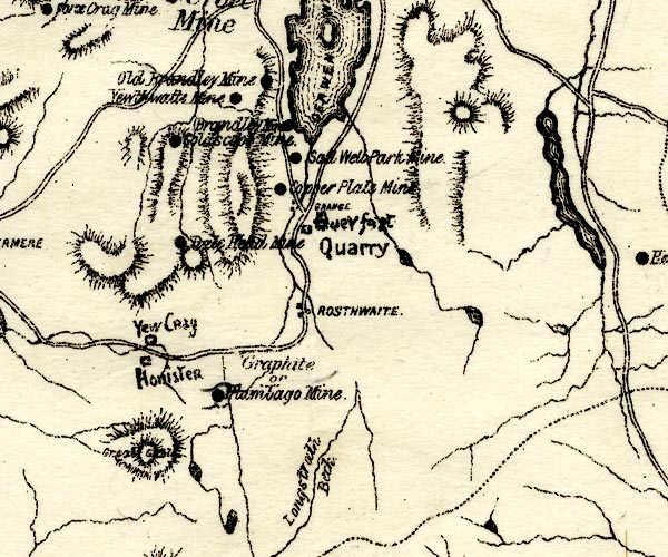 PST2NY21.jpg "Dale Head Mine" mine symbol item:- JandMN : 162.2 Image © see bottom of page |
|
|
|
||
| evidence:- | visit log:- KDMRS 1979-82 placename:- Dale Head Mines item:- galena; blende; copper pyrites |
|
| source data:- | Notes, log book of Geological Outings, mine plans, etc, Kendal
and District Mine Research Society, Kendal area, Cumbria, etc,
visits made 1979-82. Geological Outing of the Kendal and District Mine Research Society Log book page 49:- "DATE - SUNDAY 6/4/80 / MAP REF - 2235/1560 (NY21) / LOCATION - DALE HEAD / NAME - DALE HEAD MINES / TYPE OF SITE - MINES / WORKING OR DISUSED - DISUSED / PEOPLE IN PARTY [ ] / NOS. OF PHOTOS - 28 / SPECIMENS FOUND - PIECES OF GALENA, BLENDE AND COPPER PYRITES / COMMENTS - VERY WARM DAY. BORROWED A LAND ROVER TODAY, TO TAKE US OVER THE ROUGH PART OF THE ROAD, PARKED THREE QUARTERS OF THE WAY UP THE VALLEY, AND WALKED THE REST OF THE WAY UP TO THE MINES. ONE LEVEL IS STILL OPEN BUT FILLED WITH WATER, TOO DEEP TO ENTER, THE REST OF THE ENTRANCES TO THIS MINE, ARE SHAFTS, ALSO FILLED WITH WATER, WITH THE EXCEPTION OF ONE DEEP OPEN CUT WHICH IS DRY. A VERY GOOD DAY." item:- private collection : 82 Image © see bottom of page |
|
|
|
||
| evidence:- | mine drawing:- KDMRS 1979-82 |
|
| source data:- | Geological Outing of the Kendal and District Mine Research Society to Dale Head Mine,
Above Derwent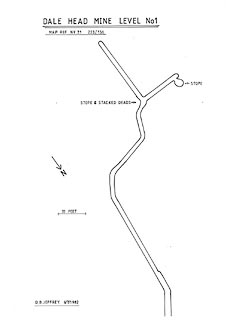 click to enlarge click to enlargeKMR16.jpg "DALE HEAD MINE LEVEL No 1" item:- private collection : 82 Image © see bottom of page |
|
|
|
||
| :- |
Below Dalehead Crags. |
|
| Malachite on the spoil heaps. |
||
| Adams, John: 1988: Mines of the Lake District Fells: Dalesman Books (Lancaster, Lancashire)::
ISBN 0 85206 931 6 |
||
|
|
||
Lakes Guides menu.