 Old Cumbria Gazetteer
 |
 |
|
| Diccan Pot, North Yorkshire | ||
| Diccan Pot | ||
| Dicken Pot | ||
| county:- | North Yorkshire | |
| locality type:- | cave | |
| locality type:- | pothole | |
| coordinates:- | SD775757 | |
| 1Km square:- | SD7775 | |
| 10Km square:- | SD77 | |
| SummaryText:- | Explored by Yorkshire Ramblers Club, 1923; and a complete descent by the Gritstone Club, 1932. | |
| SummaryText:- | Grade IV; permission, North Cote, Selside; subject to sudden flooding. | |
| references:- | Brook, A & Brook, D & Davies, G M &Long, M H: 1975: Northern Caves, vol.3 Ingleborough:
Dalesman Books (Clapham, North Yorkshire):: ISBN 0 85206 312 1 |
|
|
|
||
| evidence:- | descriptive text:- Otley 1823 (8th edn 1849) placename:- Dicken Pot |
|
| source data:- | Guide book, A Concise Description of the English Lakes, the
mountains in their vicinity, and the roads by which they may be
visited, with remarks on the mineralogy and geology of the
district, by Jonathan Otley, published by the author, Keswick,
Cumberland now Cumbria, by J Richardson, London, and by Arthur
Foster, Kirkby Lonsdale, Cumbria, 1823; published 1823-49,
latterly as the Descriptive Guide to the English Lakes. goto source goto sourcePage 202:- "..." "DICKEN POT is a long passage running in a contrary direction to Long Churn, and it terminates in a lofty dome called 'St. Paul's.'" |
|
|
|
||
| evidence:- | descriptive text:- Balderston c1890 placename:- Dicken Pot Cave |
|
| source data:- | Book, Ingleton, Bygone and Present, by Robert R and Margaret
Balderston, published by Simpkin, Marshall and Co, London, and
by Edmndson and Co, 24 High Street, Skipton, Yorkshire, about
1890. goto source page 53:- "..." "Long Churn and Dicken Pot Caves." "About one hundred yards north north-west of Alum Pot, is Long Churn Cave, and nearly a quarter-of-a-mile further is the upper mouth of Dicken Pot. ..." "Dicken Pot is formed by a branch of the same stream in the higher part of its course, and was approached by us from its upper mouth, which is small, and found close to a fence, at the foot of an allotment. In one place there is a lofty cavity, called 'St. Paul's.' A large number of pot holes and shakeholes engulf streams, descending from the slopes of the mountain further north. Dicken Pot Cave has, in a great part of its course, a most wonderful appearance. It is grooved in the rock so near the surface of the ground, that it is open above in many places, having great cross-bars and projecting slabs of limestone partially roofing it in; in others the roof is solid, but we traversed one hundred and eleven yards of it, which presented this constantly changing character." |
|
|
|
||
| evidence:- | old map:- Balderston c1890 map placename:- Dicken Pot Cave |
|
| source data:- | Map, the hills in the Ingleton area, probably by Robert R
Balderston, engraved by Goodall and Suddick, Leeds, West
Yorkshire, about 1890.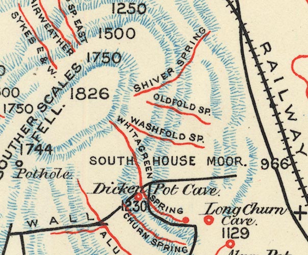 BS1SD77T.jpg "Dicken Pot Cave" item:- private collection : 27.1 Image © see bottom of page |
|
|
|
||
Lakes Guides menu.