 Old Cumbria Gazetteer
 |
 |
|
| Farleton Knott, Beetham | ||
| Farleton Knott | ||
| site name:- | Farleton Fell | |
| civil parish:- | Beetham (formerly Westmorland) | |
| county:- | Cumbria | |
| locality type:- | rocks | |
| coordinates:- | SD54208036 (etc) | |
| 1Km square:- | SD5480 | |
| 10Km square:- | SD58 | |
|
|
||
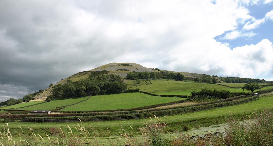 Click to enlarge BZB57.jpg (taken 16.8.2013) 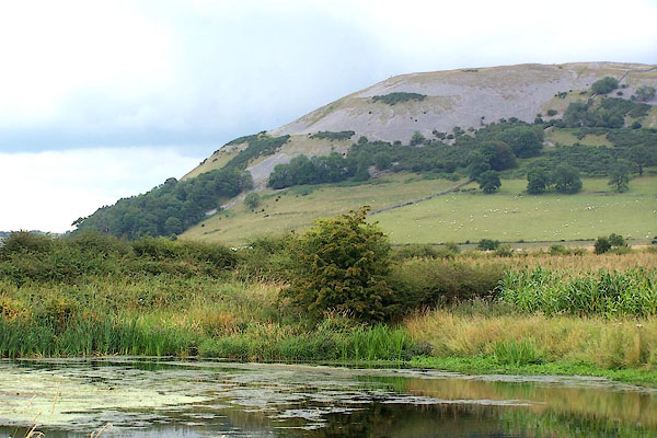 BJS20.jpg From the west. (taken 12.8.2005) |
||
|
|
||
| evidence:- | old map:- OS County Series (Wmd 47 1) placename:- Farleton Knott |
|
| source data:- | Maps, County Series maps of Great Britain, scales 6 and 25
inches to 1 mile, published by the Ordnance Survey, Southampton,
Hampshire, from about 1863 to 1948. |
|
|
|
||
| evidence:- | old map:- Saxton 1579 placename:- Farleton Knot Hill |
|
| source data:- | Map, hand coloured engraving, Westmorlandiae et Cumberlandiae Comitatus ie Westmorland
and Cumberland, scale about 5 miles to 1 inch, by Christopher Saxton, London, engraved
by Augustinus Ryther, 1576, published 1579-1645.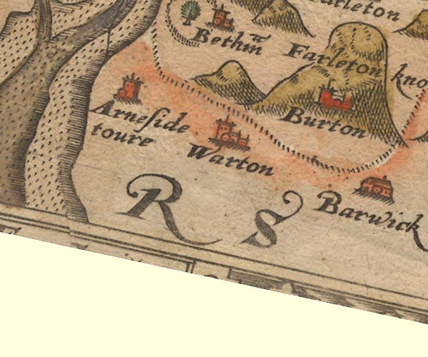 Sax9SD47.jpg "Farleton knot hill" Large hillock. item:- private collection : 2 Image © see bottom of page |
|
|
|
||
| evidence:- | old map:- Speed 1611 (Wmd) placename:- Farleton Knothill |
|
| source data:- | Map, hand coloured engraving, The Countie Westmorland and
Kendale the Cheif Towne, scale about 2.5 miles to 1 inch, by
John Speed, 1610, published by George Humble, Popes Head Alley,
London, 1611-12.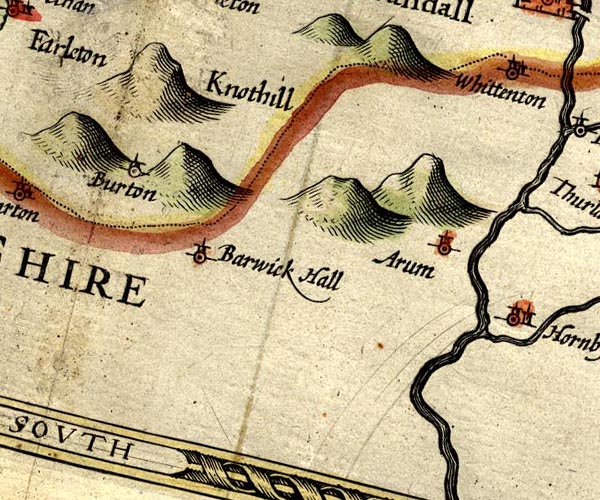 SP14SD57.jpg "Farleton Knothill" hillock item:- Armitt Library : 2008.14.5 Image © see bottom of page |
|
|
|
||
| evidence:- | old map:- Jansson 1646 placename:- Farleton Knot Hill |
|
| source data:- | Map, hand coloured engraving, Cumbria and Westmoria, ie
Cumberland and Westmorland, scale about 3.5 miles to 1 inch, by
John Jansson, Amsterdam, Netherlands, 1646.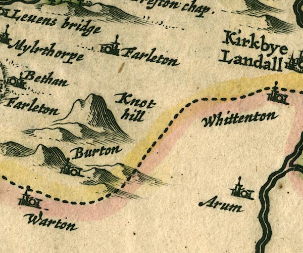 JAN3SD57.jpg "Farleton Knot hill" Lumpy hillock. item:- JandMN : 88 Image © see bottom of page |
|
|
|
||
| evidence:- | possibly old map:- Ogilby 1675 (plate 38) placename:- Holton Crag |
|
| source data:- | Road strip map, hand coloured engraving, continuation of the
Road from London to Carlisle, scale about 1 inch to 1 mile, by
John Ogilby, London, 1675.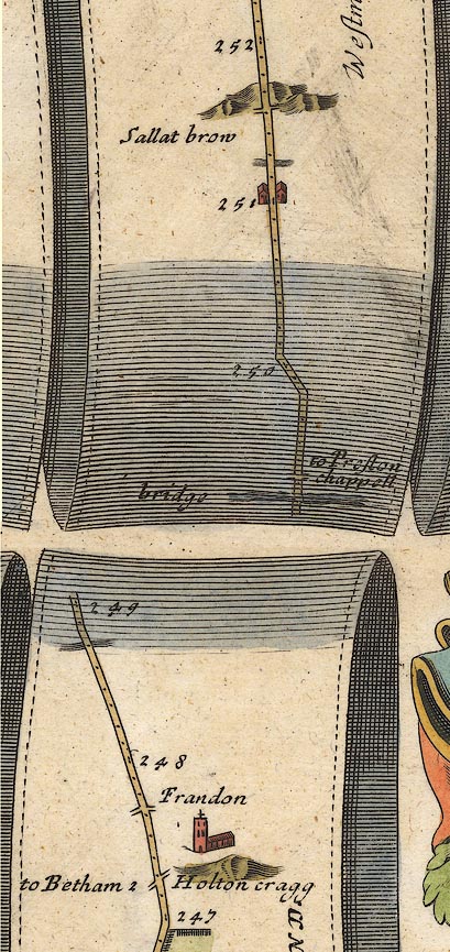 OG38m247.jpg In mile 247, Westmorland. A hillock right of the road:- "Holton cragg" item:- JandMN : 21 Image © see bottom of page |
|
|
|
||
| evidence:- | old map:- Seller 1694 (Wmd) placename:- Knot Hill |
|
| source data:- | Map, hand coloured engraving, Westmorland, scale about 8 miles
to 1 inch, by John Seller, 1694. click to enlarge click to enlargeSEL7.jpg "Knot hill" hillock; mountain or hill item:- Dove Cottage : 2007.38.87 Image © see bottom of page |
|
|
|
||
| evidence:- | old map:- Morden 1695 (Wmd) placename:- Farleton Knothill |
|
| source data:- | Map, hand coloured engraving, Westmorland, scale about 2.5 miles to 1 inch, by Robert
Morden, published by Abel Swale, the Unicorn, St Paul's Churchyard, Awnsham, and John
Churchill, the Black Swan, Paternoster Row, London, 1695.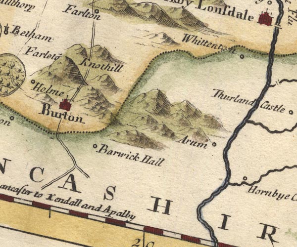 MD10SD57.jpg "Farleto~ Knothill" Hillock. item:- JandMN : 24 Image © see bottom of page |
|
|
|
||
| evidence:- | old map:- Bowen 1720 (plate 93) placename:- Holton Crag |
|
| source data:- | Strip maps, uncoloured engravings, road maps, The Road from
London to Carlisle, scale about 2 miles to 1 inch, with sections
in Lancashire and Westmorland, published by Emanuel Bowen, St
Katherines, London, 1720.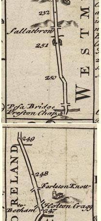 B093m247.jpg At mile 247. item:- Dove Cottage : 2007.38.100 Image © see bottom of page |
|
|
|
||
| evidence:- | old map:- Bowen 1720 (plate 93) placename:- Farleton Knot |
|
| source data:- | Strip maps, uncoloured engravings, road maps, The Road from
London to Carlisle, scale about 2 miles to 1 inch, with sections
in Lancashire and Westmorland, published by Emanuel Bowen, St
Katherines, London, 1720. B093m247.jpg At mile 247-248. item:- Dove Cottage : 2007.38.100 Image © see bottom of page |
|
|
|
||
| evidence:- | old map:- Jefferys 1770 (Wmd) placename:- Farlton Knot |
|
| source data:- | Map, 4 sheets, The County of Westmoreland, scale 1 inch to 1
mile, surveyed 1768, and engraved and published by Thomas
Jefferys, London, 1770.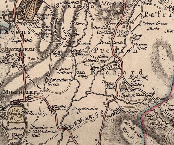 J5SD58SW.jpg "FARLTON KNOT" hill hachuring; hill or mountain item:- National Library of Scotland : EME.s.47 Image © National Library of Scotland |
|
|
|
||
| evidence:- | descriptive text:- West 1778 (11th edn 1821) placename:- Farlton Knot item:- limestone; shillow |
|
| source data:- | Guide book, A Guide to the Lakes, by Thomas West, published by
William Pennington, Kendal, Cumbria once Westmorland, and in
London, 1778 to 1821. goto source goto sourcePage 101, footnote:- "..." "The greatest quantity of limestone hills contained in this tour lie within the district bounded by Kendal, Witherslack, Kellet, and Hutton roof. And the most beautiful of them, as seen at a distance, are Farlton and Arnside knots, Witherslack-scar, and Warton-crag. The two first have their highest parts, which are neatly rounded, covered in a great measure with small fragments of limestone (called shillow) which gives them at all times an uncommon and beautiful appearance. But at the latter end of the year, when the foliage of the copses on their sides, and the grass which is interspersed along their glades near their tops, have gained an olive hue, no objects of the kind can appear more elegantly coloured. Farlton knot, especially at that time of year, as seen from Burton church-yard, exhibits a brightness and harmony of colouring, which could little be expected to result from a mixture of grass, wood, and stone." "A travelling party desirous of being gratified with the pleasure of one of these rides, may have it in perfection by going upon Farlton-knot, from Burton, through Claythorp, or traversing the heights of Warton-crag; both of which mountains, besides the particulars here mentioned, afford very extensive views, including part of the ocean, of a country abounding with agreeable images of rural nature." "..." goto sourcePage 189:- "reach Burton, Farlton-knot,[1] a beautiful naked limestone mountain, said to resemble much in form the rock of Gibraltar." "[1] By a trigonometrical process, the height of the monument was found to be 594 feet above the level of the turnpike." goto sourceAddendum; Mr Gray's Journal, 1769 Page 215:- "..." "Oct. 10. I proceeded by Burton to Lancaster, twenty-two miles; ... Passed at the foot of Farlton-knot, a high fell." goto sourceTour to the Caves in the West Riding of Yorkshire, late 18th century Page 239:- "..." "About six o'clock, one morning in June, we set off from Kendal, and, after travelling about a dozen miles along a good turnpike-road, ... we arrived at Kirkby-Lonsdale soon after eight. About the mid-way we left the little steep white mountain, Farlton-knot, on the right about a mile. It is all composed of solid limestone, and is two or three hundred yards in height. Those who have seen both, say, that on the west side it is very like the rock of Gilbraltar. ..." |
|
|
|
||
| evidence:- | old map:- West 1784 map placename:- Farleton Knot |
|
| source data:- | Map, hand coloured engraving, A Map of the Lakes in Cumberland,
Westmorland and Lancashire, scale about 3.5 miles to 1 inch,
engraved by Paas, 53 Holborn, London, about 1784.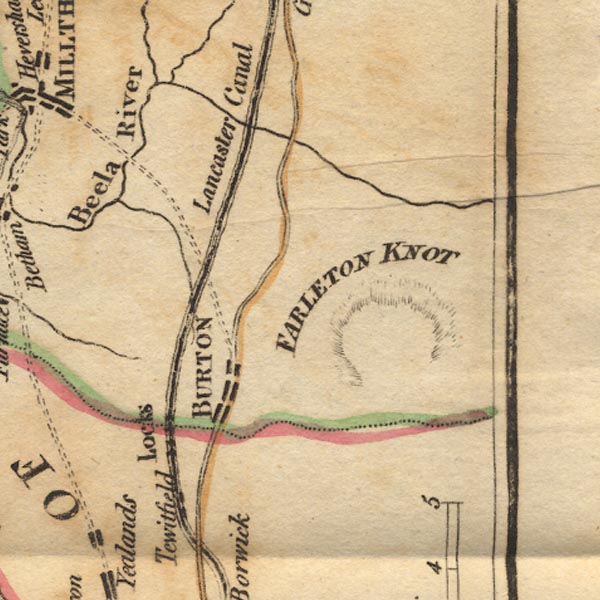 Ws02SD57.jpg "FARLETON KNOT" A part ring of hachuring marks the hill. item:- Armitt Library : A1221.1 Image © see bottom of page |
|
|
|
||
| evidence:- | old map:- Cary 1789 (edn 1805) placename:- Farlton Knot |
|
| source data:- | Map, uncoloured engraving, Westmoreland, scale about 2.5 miles
to 1 inch, by John Cary, London, 1789; edition 1805.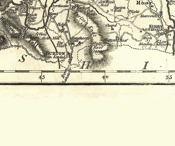 CY24SD57.jpg "Farlton Knot" hill hachuring item:- JandMN : 129 Image © see bottom of page |
|
|
|
||
| evidence:- | probably descriptive text:- Baker 1802 |
|
| source data:- | Perspective road map with sections in Lancashire, Westmorland,
and Cumberland, by J Baker, London 1802. pp.25-26:- "... On leaving it [Burton], to the right of the road, may be observed a tremendous barren rock near 600 feet above the common level of the road. ..." |
|
|
|
||
| evidence:- | old map:- Otley 1818 placename:- Faralton |
|
| source data:- | Map, uncoloured engraving, The District of the Lakes,
Cumberland, Westmorland, and Lancashire, scale about 4 miles to
1 inch, by Jonathan Otley, 1818, engraved by J and G Menzies,
Edinburgh, Scotland, published by Jonathan Otley, Keswick,
Cumberland, et al, 1833.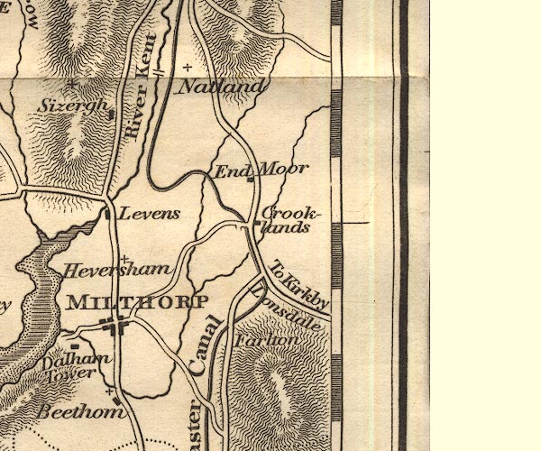 OT02SD58.jpg item:- JandMN : 48.1 Image © see bottom of page |
|
|
|
||
| evidence:- | descriptive text:- Otley 1823 (5th edn 1834) placename:- Farlton Knot item:- geology; limestone pavement |
|
| source data:- | Guide book, A Concise Description of the English Lakes, the
mountains in their vicinity, and the roads by which they may be
visited, with remarks on the mineralogy and geology of the
district, by Jonathan Otley, published by the author, Keswick,
Cumberland now Cumbria, by J Richardson, London, and by Arthur
Foster, Kirkby Lonsdale, Cumbria, 1823; published 1823-49,
latterly as the Descriptive Guide to the English Lakes. goto source Page 93:- "... Warton Crag on the left, and Farlton Knot on the right of the road, are two stratified hills of limestone, rising to a considerable height: the latter said to be nearly 600 feet above the road. ..." "..." goto sourcePage 161:- "A superincumbent bed of limestone, by some called the mountain, by others the upper transition limestone, mantles round these mountains, in a position unconformable to the strata of the slaty and other rocks upon which it reposes. It bassets out near ..." goto sourcePage 162:- "... it may be seen upon the surface as far as Warton and Farleton Crags, ..." |
|
|
|
||
| evidence:- | old text:- Gents Mag placename:- Farlton Knot |
|
| source data:- | Magazine, The Gentleman's Magazine or Monthly Intelligencer or
Historical Chronicle, published by Edward Cave under the
pseudonym Sylvanus Urban, and by other publishers, London,
monthly from 1731 to 1922. goto source Gentleman's Magazine 1825 part 1 p.515 "Compendium of County History. - Westmorland." "FARLTON KNOT is said to bear a strong resemblance in form to the rock of Gibraltar." |
|
|
|
||
Lakes Guides menu.