 Old Cumbria Gazetteer
 |
 |
|
| Foulney Twist, Morecambe Bay | ||
| Foulney Twist | ||
| locality:- | Morecambe Bay | |
| civil parish:- | Barrow-in-Furness (formerly Lancashire) | |
| county:- | Cumbria | |
| locality type:- | rocks | |
| locality type:- | shoal | |
| locality type:- | sands | |
| coordinates:- | SD24886306 (etc, uncertain) | |
| 1Km square:- | SD2463 | |
| 10Km square:- | SD26 | |
|
|
||
| evidence:- | old text:- Mackenzie 1776 placename:- Fowla Twists |
|
| source data:- | Charts, and sailing directions, Nautical Descriptions of the
West Coast of Great Britain, Bristol Channel to Cape Wrath, by
Murdoch Mackenzie, published London, 1776. goto source goto sourcePage 18:- "... ..." "Fowla Twists. / On the south side of this channel, there is a rock called Fowla Twists, which dries at low spring-tide only, and extends south-westward from Fowla Island, about a mile. To avoid this rock; keep the eastmost sand-hillocks, on Haw's-end, north, till you are about a cable's-length from the shore, or half a cable from the edge of the sea; or keep the extremity of the Haw's Point on the old castle, till you are within a cable's-length of the shore, then steer N.E. or on the Old Garth Point in Fowla, giving the Point at the old castle a birth of a cable's-length, and steer for Ro Island anchorage." |
|
|
|
||
| evidence:- | HO chart:- Hydrographic Office 1850s onwards item:- perch |
|
| source data:- | Chart, uncoloured engraving, England West Coast sheet XI,
Fleetwood to the Firth of Solway, scale about 2.5 miles to 1
inch, by H Denham and G Williams, 1846, engraved by J and C
Walker, published by the Hydrographic Office, 1850 corrected to
1863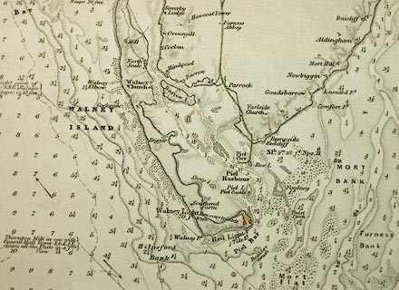 click to enlarge click to enlargeHY01P1.jpg "Twist Perch" item:- Carlisle Library : Map 93 Image © Carlisle Library |
|
|
|
||
Lakes Guides menu.