 Old Cumbria Gazetteer
 |
 |
|
| Gillerthwaite, Loweswater | ||
| Gillerthwaite | ||
| locality:- | Loweswater | |
| civil parish:- | Loweswater (formerly Cumberland) | |
| county:- | Cumbria | |
| locality type:- | buildings | |
| coordinates:- | NY14382103 | |
| 1Km square:- | NY1421 | |
| 10Km square:- | NY12 | |
|
|
||
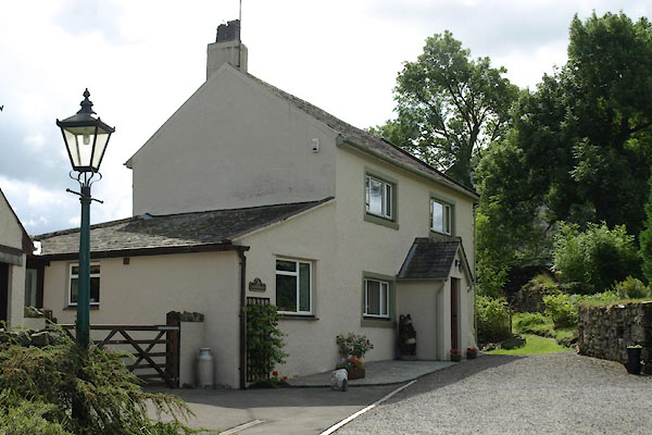 BVF15.jpg (taken 17.8.2011) |
||
|
|
||
| evidence:- | old map:- OS County Series (Cmd 63 9) placename:- Gillerthwaite |
|
| source data:- | Maps, County Series maps of Great Britain, scales 6 and 25
inches to 1 mile, published by the Ordnance Survey, Southampton,
Hampshire, from about 1863 to 1948. "Gillerthwaite / Post Office" |
|
|
|
||
| evidence:- | old map:- Donald 1774 (Cmd) placename:- Gillerthwat |
|
| source data:- | Map, hand coloured engraving, 3x2 sheets, The County of Cumberland, scale about 1
inch to 1 mile, by Thomas Donald, engraved and published by Joseph Hodskinson, 29
Arundel Street, Strand, London, 1774.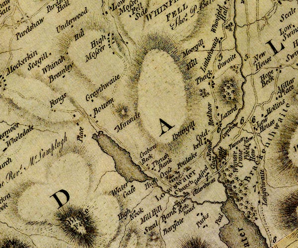 D4NY12SW.jpg "Gillerthwat" block or blocks, labelled in lowercase; a hamlet or just a house item:- Carlisle Library : Map 2 Image © Carlisle Library |
|
|
|
||
| evidence:- | old map:- Crosthwaite 1783-94 (But/Cru/Low) placename:- Gillerthwaite |
|
| source data:- | Map, uncoloured engraving, An Accurate Map of Buttermere,
Crummock and Loweswater Lakes, scale about 3 inches to 1 mile,
by Peter Crosthwaite, Keswick, Cumberland, 1794, version
published 1800.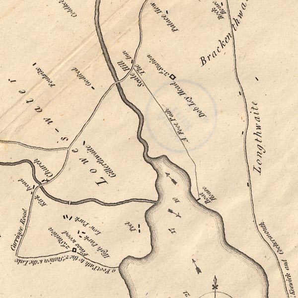 CT8NY12K.jpg "Gillerthwaite" item:- Armitt Library : 1959.191.2 Image © see bottom of page |
|
|
|
||
| evidence:- | old map:- Otley 1818 placename:- Gillerthwaite |
|
| source data:- | Map, uncoloured engraving, The District of the Lakes,
Cumberland, Westmorland, and Lancashire, scale about 4 miles to
1 inch, by Jonathan Otley, 1818, engraved by J and G Menzies,
Edinburgh, Scotland, published by Jonathan Otley, Keswick,
Cumberland, et al, 1833.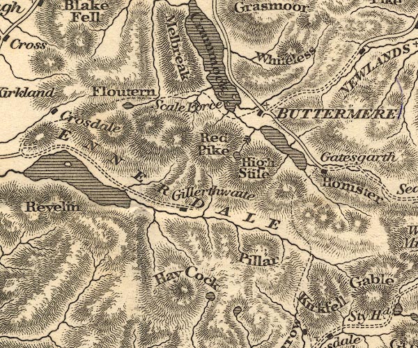 OT02NY11.jpg item:- JandMN : 48.1 Image © see bottom of page |
|
|
|
||
| evidence:- | outline view:- Otley 1823 (8th edn 1849) placename:- Gilterthwaite |
|
| source data:- | Engraving, outline view of mountains, Crummock and Buttermere from the Road near Loweswater
Church, drawn by T Binns, engraved by O Jewitt, opposite p.18 of A Descriptive Guide
of the English Lakes, by Jonathan Otley, 8th edition, 1849.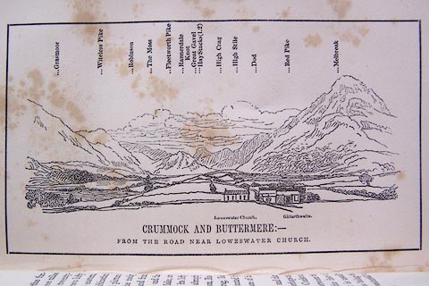 click to enlarge click to enlargeO80E10.jpg item:- Armitt Library : A1180.11 Image © see bottom of page |
|
|
|
||
| evidence:- | old drawing:- Aspland 1840s-60s placename:- Gillerthwaite |
|
| source data:- | Drawing, pencil, Gillerthwaite, Loweswater, Cumberland, by Theophilus Lindsey Aspland,
17 July 1846.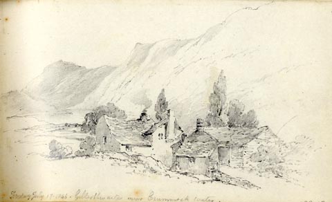 click to enlarge click to enlargeAS0247.jpg "Friday July 17. 1846. Gillerthwaite near Crummock Water." page number "42" item:- Armitt Library : 1958.488.47 Image © see bottom of page |
|
|
|
||
| evidence:- | old print:- Heaton Cooper 1905 (edn 1908) placename:- Old Post Office, The |
|
| source data:- | Print, colour halftone, The Old Post Office, Loweswater, Cumberland, from a watercolour
painting by Alfred Heaton Cooper, published by Adam and Charles Black, London, 2nd
edn 1908.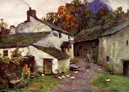 click to enlarge click to enlargeHC0140.jpg Now Gillerthwaite, Loweswater. Opposite p.108 of The English Lakes, painted by Alfred Heaton Cooper, described by William T Palmer. printed at tissue opposite the print:- "THE OLD POST OFFICE, LOWESWATER" printed at signed lower right:- "A HEATON COOPER" item:- JandMN : 468.40 Image © see bottom of page |
|
|
|
||
| evidence:- | old print:- Bogg 1898 item:- wheelbarrow; communication |
|
| source data:- | Print, engraving, Post Office, Gillerthwaite, Loweswater, Cumberland, by A Haselgrave,
1897, published by Edmund Bogg, 3 Woodhouse Lane, and James Miles, Guildford Street,
Leeds, Yorkshire, 1898.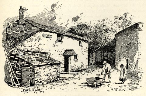 click to enlarge click to enlargeBGG175.jpg Included on p.192 of Lakeland and Ribblesdale, by Edmund Bogg. item:- JandMN : 231.75 Image © see bottom of page |
|
|
|
||
 Lakes Guides menu.