 Old Cumbria Gazetteer
 |
 |
|
||||||||||||
| Gowbarrow Park, Matterdale | ||||||||||||||
| Gowbarrow Park | ||||||||||||||
| civil parish:- | Matterdale (formerly Cumberland) | |||||||||||||
| county:- | Cumbria | |||||||||||||
| locality type:- | park | |||||||||||||
| coordinates:- | NY40822126 (etc) | |||||||||||||
| 1Km square:- | NY4021 | |||||||||||||
| 10Km square:- | NY42 | |||||||||||||
|
|
||||||||||||||
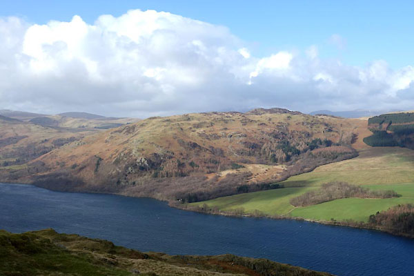 BZZ19.jpg (taken 27.2.2014) |
||||||||||||||
|
|
||||||||||||||
| evidence:- | old map:- OS County Series (Cmd 65 12) placename:- Gowbarrow Park |
|||||||||||||
| source data:- | Maps, County Series maps of Great Britain, scales 6 and 25
inches to 1 mile, published by the Ordnance Survey, Southampton,
Hampshire, from about 1863 to 1948. |
|||||||||||||
|
|
||||||||||||||
| evidence:- | old map:- Saxton 1579 |
|||||||||||||
| source data:- | Map, hand coloured engraving, Westmorlandiae et Cumberlandiae Comitatus ie Westmorland
and Cumberland, scale about 5 miles to 1 inch, by Christopher Saxton, London, engraved
by Augustinus Ryther, 1576, published 1579-1645. Sax9NY42.jpg Fence palings, trees, by Ullswater. item:- private collection : 2 Image © see bottom of page |
|||||||||||||
|
|
||||||||||||||
| evidence:- | old map:- Speed 1611 (Cmd) |
|||||||||||||
| source data:- | Map, hand coloured engraving, Cumberland and the Ancient Citie
Carlile Described, scale about 4 miles to 1 inch, by John Speed,
1610, published by J Sudbury and George Humble, Popes Head
Alley, London, 1611-12. SP11NY42.jpg ring of fence palings, trees item:- private collection : 16 Image © see bottom of page |
|||||||||||||
|
|
||||||||||||||
| evidence:- | old map:- Jansson 1646 |
|||||||||||||
| source data:- | Map, hand coloured engraving, Cumbria and Westmoria, ie
Cumberland and Westmorland, scale about 3.5 miles to 1 inch, by
John Jansson, Amsterdam, Netherlands, 1646. JAN3NY42.jpg Ring of fence palings with trees. item:- JandMN : 88 Image © see bottom of page |
|||||||||||||
|
|
||||||||||||||
| evidence:- | old map:- Morden 1695 (Cmd) |
|||||||||||||
| source data:- | Map, uncoloured engraving, Cumberland, scale about 4 miles to 1
inch, by Robert Morden, 1695, published by Abel Swale, the
Unicorn, St Paul's Churchyard, Awnsham, and John Churchill, the
Black Swan, Paternoster Row, London, 1695-1715.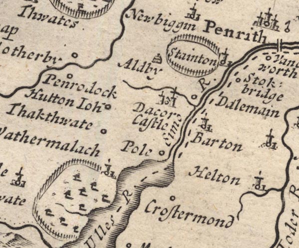 MD12NY42.jpg Ring of fence palings, trees. item:- JandMN : 90 Image © see bottom of page |
|||||||||||||
|
|
||||||||||||||
| evidence:- | old map:- Morden 1695 (Wmd) placename:- Gowburrow Park |
|||||||||||||
| source data:- | Map, hand coloured engraving, Westmorland, scale about 2.5 miles to 1 inch, by Robert
Morden, published by Abel Swale, the Unicorn, St Paul's Churchyard, Awnsham, and John
Churchill, the Black Swan, Paternoster Row, London, 1695.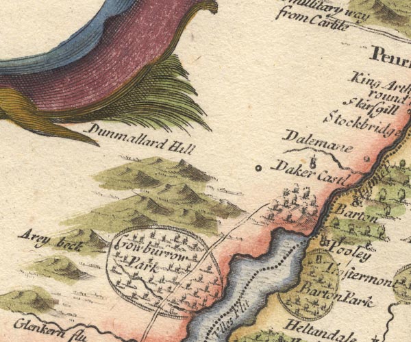 MD10NY42.jpg "Gowburrow park" Ring of fence palings, trees, stream, road and circle for a place. item:- JandMN : 24 Image © see bottom of page |
|||||||||||||
|
|
||||||||||||||
| evidence:- | old map:- Bowen and Kitchin 1760 placename:- Goubarrow |
|||||||||||||
| source data:- | Map, hand coloured engraving, A New Map of the Counties of
Cumberland and Westmoreland Divided into their Respective Wards,
scale about 4 miles to 1 inch, by Emanuel Bowen and Thomas
Kitchin et al, published by T Bowles, Robert Sayer, and John
Bowles, London, 1760.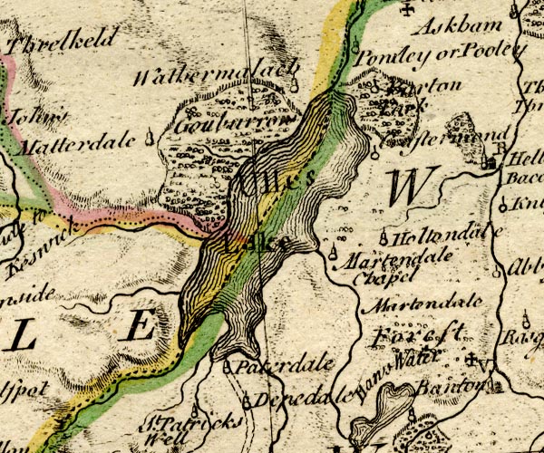 BO18NY31.jpg "Goubarrow" outline of fence palings, trees item:- Armitt Library : 2008.14.10 Image © see bottom of page |
|||||||||||||
|
|
||||||||||||||
| evidence:- | old map:- Donald 1774 (Cmd) placename:- Gowbarrow Parks |
|||||||||||||
| source data:- | Map, hand coloured engraving, 3x2 sheets, The County of Cumberland, scale about 1
inch to 1 mile, by Thomas Donald, engraved and published by Joseph Hodskinson, 29
Arundel Street, Strand, London, 1774. D4NY32SE.jpg 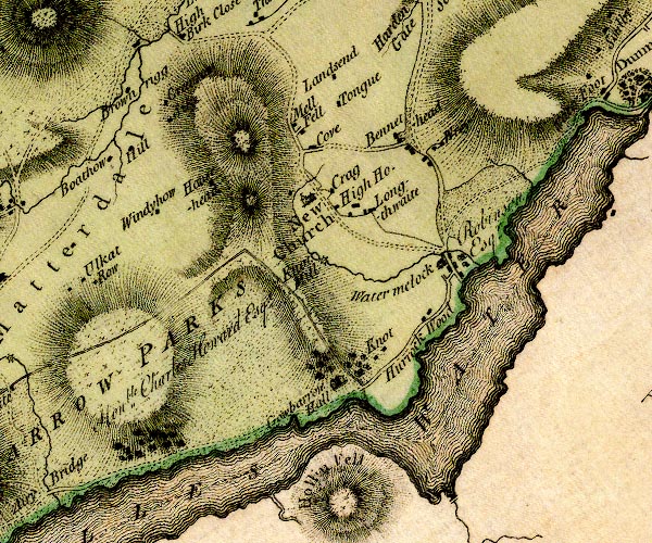 D4NY42SW.jpg "GOWBARROW PARKS / Honble. Charles Howard Esqr." outline, double line, plus lake shore item:- Carlisle Library : Map 2 Images © Carlisle Library |
|||||||||||||
|
|
||||||||||||||
| evidence:- | descriptive text:- West 1778 (11th edn 1821) |
|||||||||||||
| source data:- | Guide book, A Guide to the Lakes, by Thomas West, published by
William Pennington, Kendal, Cumbria once Westmorland, and in
London, 1778 to 1821. goto source goto sourcePage 155:- "... Gowbarrow-park opens with a grand amphitheatre of shining rock, the floor of which is spread with soft green pasture, once shaded with ancient oaks, to which many decayed roots bear witness, Scattered thorns, trees, and bushes vary the ground, which is pastured with flocks, herds of cattle, and fallow deer. ..." |
|||||||||||||
|
|
||||||||||||||
| evidence:- | old map:- Crosthwaite 1783-94 (Ull) |
|||||||||||||
| source data:- | Map, uncoloured engraving, Accurate Map of the Beautiful Lake of
Ullswater, scale about 3 inches to 1 mile, by Peter Crosthwaite,
Keswick, Cumberland, 1783, version published 1800.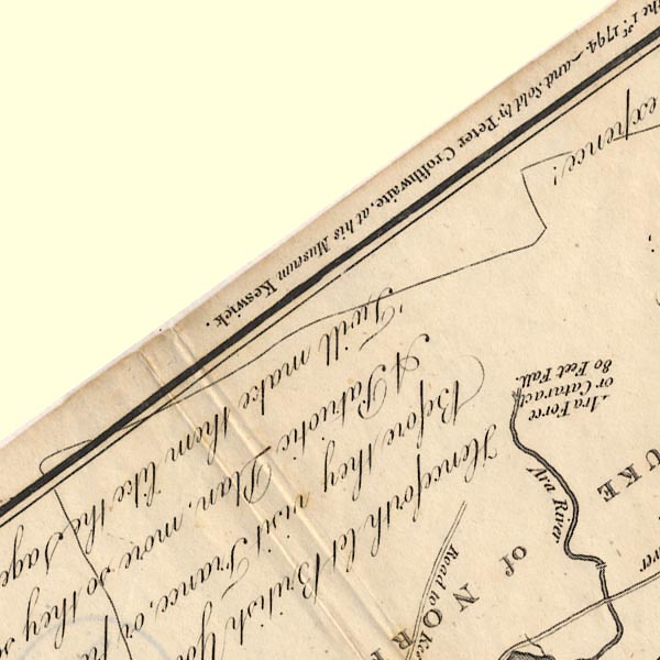 CT5NY32V.jpg The park is drawn in outline. 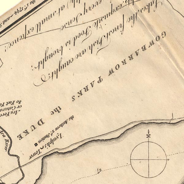 CT5NY42A.jpg "GOWBARROW PARKS the DUKE of NORFOLK's E. of Surrey, Hereditary Earl-Marshall, Premier D. &c. &c. &c." 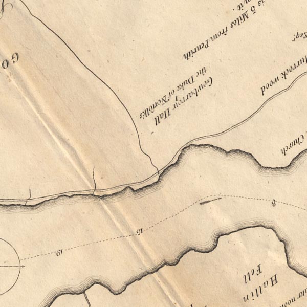 CT5NY42F.jpg 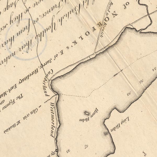 CT5NY31Z.jpg item:- Armitt Library : 1959.191.7 Image © see bottom of page |
|||||||||||||
|
|
||||||||||||||
| evidence:- | old map:- West 1784 map placename:- Gowbarrow Park |
|||||||||||||
| source data:- | Map, hand coloured engraving, A Map of the Lakes in Cumberland,
Westmorland and Lancashire, scale about 3.5 miles to 1 inch,
engraved by Paas, 53 Holborn, London, about 1784. Ws02NY32.jpg  Ws02NY42.jpg item:- Armitt Library : A1221.1 Image © see bottom of page |
|||||||||||||
|
|
||||||||||||||
| evidence:- | old text:- Clarke 1787 placename:- Gowbarrow Park item:- fox hound; fox; Forester's Corn; pine marten; clean mart; badger; wild cat; eagle; raven; foul mart; polecat; deer |
|||||||||||||
| source data:- | Guide book, A Survey of the Lakes of Cumberland, Westmorland,
and Lancashire, written and published by James Clarke, Penrith,
Cumberland, and in London etc, 1787; published 1787-93. goto source Page 29:- "..." "Before we leave Gowbarrow Park, (for the bounds of which see the Plan,) it may not be amiss to mention some particulars of its history. This Park was one of the forests proclaimed by William Rufus, and is now the property of the Right Honourable Charles Howard, Earl of Surrey, of whose illustrious family and titles I shall inform my readers more at large hereafter." "The lower part of Gowbarrow was formerly meer'd out of the tenants of the manor of Water-Millock, who were to have as much of the produce as they could take with scythe, together with hay bounds, fern bounds, green hue, &c. These they lost in a law-suit with the lord, into which they were inadvertently drawn; for the whole of the tenants of the barony of Graystock quarrelling with their lord about some of their privileges, instituted a joint suit against him: in this complaint, it was set forth, that they had all enjoyed these privileges time out of mind, (which in fact none but the tenants of Water-Millock ever possessed.) The Attorney having made the complaint general, the whole were nonsuited, and in consequence thereof the tenants of Water-Millock lost their undoubted rights." "Another custom, (likewise lost,) was, that the Bailiff should keep dogs for the hunting and destroying of foxes and other vermin which infest this neighbourhood, and for which he received 40 quarts of tolerable, (though not the best) oats, from every tenement, under the title of Forester's Corn. At last the Bailiff refused to keep the dogs, and the tenants upon this refused to pay the corn: in consequence of these disputes the agent for the lord came in person and demanded it, when some of the tenants instantly paid it; but others, alleging that the corn was merely an hire paid to the Bailiff for destroying noxious vermin, positively refused, and during their lives paid none: Their heirs, however, either in order to renew their leases upon easier terms, or by some other persuasions, consented to pay it, (one single tenement excepted,) and the lord now receives it." "We may naturally suppose, that in consequence of no dogs being kept, the vermin would multiply very fast: this they did to that degree, that one man, out of thirty-two lambs lost fourteen, and many others suffered proportional losses. Upon these repeated damages, the inhabitants called a vestry meeting, that they might consult for immediate remedying this evil. Some were of opinion, that an action should be brought against the lord to compel him to keep the hounds, as he received the corn paid for that purpose: but the more general opinion was, that since damages were every night done, and immediate relief must be had, it was better to hire men to destroy the vermin, than risque the precarious issue of a tedious and expensive suit at law. They thereupon raised a sum by way of cess for that purpose, and appointed the following rewards, (which are still paid) for the destruction of these noxious animals." |
|||||||||||||
| source data:- | goto source Page 30:- "They likewise procured the swiftest fox-hounds from the mountainous environs of Keswick, &c.; skilful sportsmen were also hired to attend with guns, and every other engine, for the destruction of these annoyers. Witsun-week, A.D. 1759, was fixed upon for the attack, when I myself was an eye-witness to the death of twelve foxes within the week. The sum-total of vermin destroyed, were fifteen foxes, seven badgers, twelve wild-cats, and nine martens, (called here, by way of distinction, Clean Marts;) besides a prodigious number of foul-marts, eagles, ravens, gleads, &c. The wiles and policy of the foxes were truly astonishing; such as jumping from the rocks upon trees covered with ivy, where they would sometimes conceal themselves, and defeat their pursuers; at other times they run just within the edge of Ullswater, so that no scent remained; and many other instances of sagacity, which, were I disposed to trespass upon the patience of the reader, I could relate. Gowbarrow Park contains about 2000 acres of ground, and is admirably well adapted for the preservation of deer, of which there are six or seven hundred; they divide themselves into herds, and never intermix unless when alarmed. As to the names by which they are at different ages distinguished, I must refer my reader to that part of the appendix wherein I propose to treat of the natural history of this country."
|
|||||||||||||
|
|
||||||||||||||
| evidence:- | old map:- Clarke 1787 map (Ullswater) placename:- Gowbarrow Parks |
|||||||||||||
| source data:- | Map, A Map of the Lake Ullswater and its Environs, scale about
6.5 ins to 1 mile, by James Clarke, engraved by S J Neele, 352
Strand, published by James Clarke, Penrith, Cumberland and in
London etc, 1787.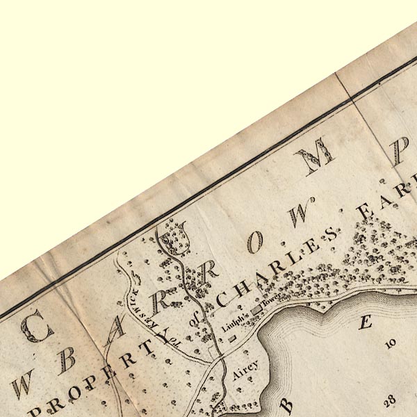 CL4NY32V.jpg 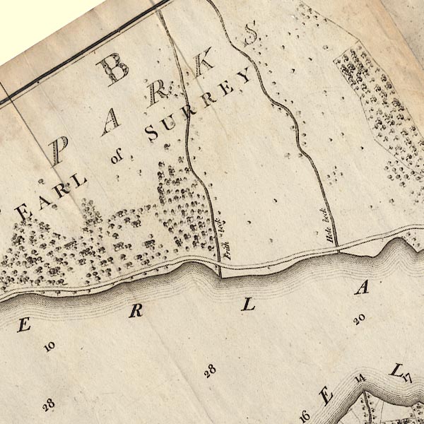 CL4NY42A.jpg "GOWBARROW PARKS / THE PROPERTY of CHARLES EARL OF SURREY" item:- private collection : 10.4 Image © see bottom of page |
|||||||||||||
|
|
||||||||||||||
| evidence:- | old map:- Cooke 1802 placename:- Gowbarrow Park |
|||||||||||||
| source data:- | Map, Cumberland, scale about 15.5 miles to 1 inch, by George
Cooke, 1802, bound in Gray's New Book of Roads, 1824, published
by Sherwood, Jones and Co, Paternoster Road, London, 1824. click to enlarge click to enlargeGRA1Cd.jpg "Gowbarrow Park" outline of fence palings; park AND building item:- Hampshire Museums : FA2000.62.2 Image © see bottom of page |
|||||||||||||
|
|
||||||||||||||
| evidence:- | old map:- Wallis 1810 (Cmd) placename:- Gowbarrow Park |
|||||||||||||
| source data:- | Road map, hand coloured engraving, Cumberland, scale about 16
miles to 1 inch, by James Wallis, 77 Berwick Stree, Soho,
London, 1810. click to enlarge click to enlargeWL13.jpg "Gowbarrow Park" outline with fence palings; park item:- Dove Cottage : 2009.81.10 Image © see bottom of page |
|||||||||||||
|
|
||||||||||||||
| evidence:- | old text:- Wordsworth 1810 placename:- Gowbarrow Park item:- deer |
|||||||||||||
| source data:- | Guide book, A Description of the Scenery of the Lakes, later A
Guide through the District of The Lakes, by William Wordsworth,
1810-35. goto source page xix "... in Gowbarrow Park, the lover of Nature might linger for hours. Here is a powerful Brook, which dashes among rocks through a deep glen, hung on every side with a rich and happy" goto sourcepage xx "intermixture of native wood; here are beds of luxuriant fern, aged hawthorns, and hollies decked with honeysuckles; and fallow-deer glancing and bounding over the lawns and through the thickets. These are the attractions of the retired views, or constitute a foreground for ever-varying pictures of the majestic Lake, forced to take a winding course by bold promontories, and environed by mountains of sublime form, towering above each other. ..." "..." goto sourcepage 131 "... At the end of Gowbarrow park a large herd of deer were either moving slowly or standing still among the fern. I was sorry when a chance-companion, who had joined us by the way, startled them with a whistle, disturbing an image of grave simplicity and thoughtful enjoyment; for I could have fancied that those natives of this wild and beautiful region were partaking with us a sensation of the solemnity of the closing day. ..." |
|||||||||||||
|
|
||||||||||||||
| evidence:- | old text:- Green 1814 item:- deer |
|||||||||||||
| source data:- | Set of prints, soft ground etchings, Sixty Small Prints, with
text, A Description of a Series of Sixty Small Prints, by
William Green, Ambleside, Westmorland, 1814. goto source page 30:- "..." "The park is well stocked with deer, whose elegant forms and wild gestures are in unison with the surrounding scenes." |
|||||||||||||
|
|
||||||||||||||
| evidence:- | old print:- Green 1815 item:- deer; clouds |
|||||||||||||
| source data:- | Print, coloured aquatint, Ulls Water taken near Lyulphs Tower, Patterdale, Westmorland,
by William Green, Ambleside, Westmorland, 1815.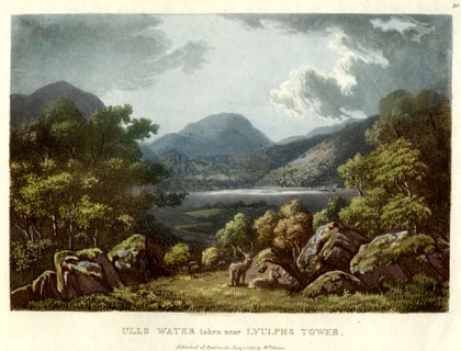 click to enlarge click to enlargeGN0519.jpg Plate 20 in Lake Scenery. printed at upper right:- "20" printed at bottom:- "ULLS WATER taken near LYULPHS TOWER. / Published at Ambleside, June 1, 1815, by Wm. Green." item:- Armitt Library : A6646.19 Image © see bottom of page |
|||||||||||||
|
|
||||||||||||||
| evidence:- | old map:- Otley 1818 placename:- Gowbarrow Parks |
|||||||||||||
| source data:- | Map, uncoloured engraving, The District of the Lakes,
Cumberland, Westmorland, and Lancashire, scale about 4 miles to
1 inch, by Jonathan Otley, 1818, engraved by J and G Menzies,
Edinburgh, Scotland, published by Jonathan Otley, Keswick,
Cumberland, et al, 1833. OT02NY32.jpg item:- JandMN : 48.1 Image © see bottom of page |
|||||||||||||
|
|
||||||||||||||
| evidence:- | old map:- Hall 1820 (Cmd) placename:- Gowbarrow Park |
|||||||||||||
| source data:- | Map, hand coloured engraving, Cumberland, scale about 21 miles
to 1 inch, engraved by Sidney Hall, published by S Leigh, 18
Strand, London, 1820-31. click to enlarge click to enlargeHA14.jpg "Gowbarrow Pk." outline of fence palings; park item:- JandMN : 91 Image © see bottom of page |
|||||||||||||
|
|
||||||||||||||
| evidence:- | outline view:- Otley 1823 (8th edn 1849) placename:- Gowbarrow |
|||||||||||||
| source data:- | Engraving, outline view of mountains, Ullswater from Pooley Bridge, drawn by T Binns,
engraved by O Jewitt, opposite p.12 of A Descriptive Guide of the English Lakes, by
Jonathan Otley, 8th edition, 1849.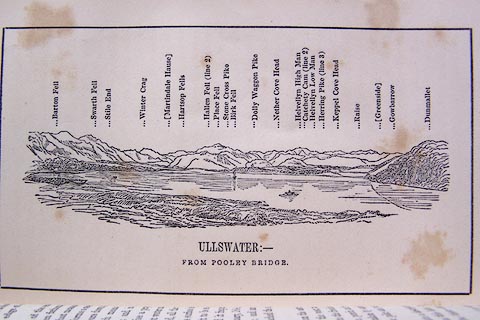 click to enlarge click to enlargeO80E07.jpg item:- Armitt Library : A1180.8 Image © see bottom of page |
|||||||||||||
|
|
||||||||||||||
| evidence:- | descriptive text:- Ford 1839 (3rd edn 1843) placename:- Gowbarrow Park |
|||||||||||||
| source data:- | Guide book, A Description of Scenery in the Lake District, by
Rev William Ford, published by Charles Thurnam, Carlisle, by W
Edwards, 12 Ave Maria Lane, Charles Tilt, Fleet Street, William
Smith, 113 Fleet Street, London, by Currie and Bowman,
Newcastle, by Bancks and Co, Manchester, by Oliver and Boyd,
Edinburgh, and by Sinclair, Dumfries, 1839. goto source Page 146:- "into the grounds of Gowbarrow Hall; and then the Park, in which is situated Lyulph's Tower, a rude hunting-seat of Henry Howard, Esq., that exhibits one of the finest views on the lake. The lover of nature may linger here for hours. A powerful brook dashes through rocks hung with a happy mixture of natural wood, beds of luxuriant fern, aged hawthorns, hollies, and honeysuckles; while fallow deer are seen glancing and bounding through the thickets and over the lawns. ..." |
|||||||||||||
|
|
||||||||||||||
| evidence:- | old map:- Ford 1839 map placename:- Gowbarrow Park |
|||||||||||||
| source data:- | Map, uncoloured engraving, Map of the Lake District of
Cumberland, Westmoreland and Lancashire, scale about 3.5 miles
to 1 inch, published by Charles Thurnam, Carlisle, and by R
Groombridge, 5 Paternoster Row, London, 3rd edn 1843.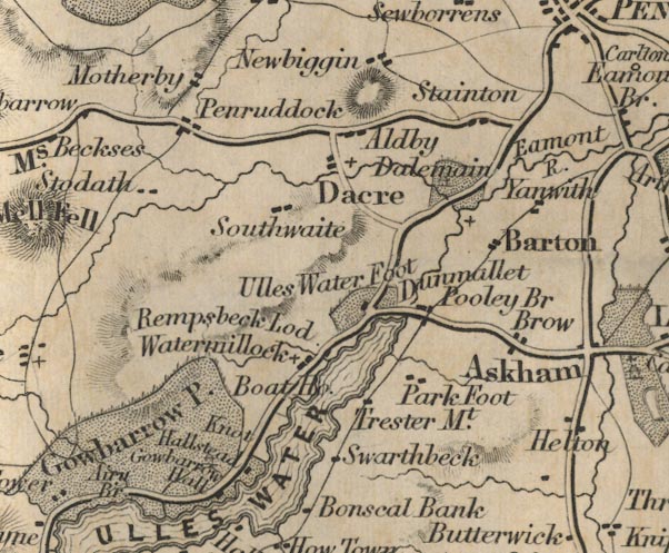 FD02NY42.jpg "Gowbarrow Park" Park; also building, labelled separately. item:- JandMN : 100.1 Image © see bottom of page |
|||||||||||||
|
|
||||||||||||||
| evidence:- | old text:- Gents Mag item:- tree felling; oak |
|||||||||||||
| source data:- | Magazine, The Gentleman's Magazine or Monthly Intelligencer or
Historical Chronicle, published by Edward Cave under the
pseudonym Sylvanus Urban, and by other publishers, London,
monthly from 1731 to 1922. goto source Gentleman's Magazine 1849 part 2 p.138 "..." "... the grey oaks of Gowbarrow, which rendered the Cumberland shores of Ullswater so glorious to behold, fell under the exterminating axe in 1780. ..." |
|||||||||||||
|
|
||||||||||||||
| evidence:- | old map:- Garnett 1850s-60s H placename:- Gowbarrow Park |
|||||||||||||
| source data:- | Map of the English Lakes, in Cumberland, Westmorland and
Lancashire, scale about 3.5 miles to 1 inch, published by John
Garnett, Windermere, Westmorland, 1850s-60s.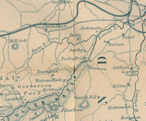 GAR2NY42.jpg "Gowbarrow Park" area item:- JandMN : 82.1 Image © see bottom of page |
|||||||||||||
|
|
||||||||||||||
| evidence:- | outline view:- Martineau 1855 |
|||||||||||||
| source data:- | Print, engraving, outline view, Mountains seen on the Keswick Road approaching Ullswater,
drawn by L Aspland, engraved by W Banks, Edinburgh, published by John Garnett, Windermere,
Westmorland, and by Whittaker and Co, London, 1855.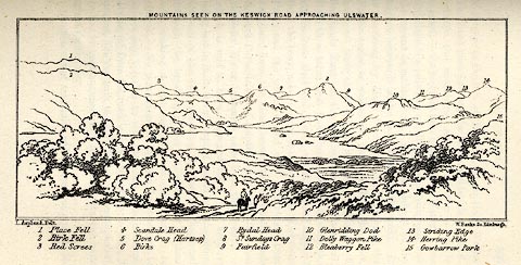 click to enlarge click to enlargeMNU115.jpg Plate opposite p.104 in A Complete Guide to the English Lakes, by Harriet Martineau. "MOUNTAINS SEEN ON THE KESWICK ROAD APPROACHING ULLSWATER." "L Aspland Delt. / W Banks Sc Edinr." The view is captioned, numbers referring to mountains in the image:- "1 Place Fell, 2 Birk Fell, 3 Red Screes, 4 Scandale Head, 5 Dove Crag (Hartsop), 6 Birks, 7 Rydal Head, 8 St. Sundays Crag, 9, Fairfield, 10 Glenridding Dod, 11 Dolly Waggon Pike, 12 Bleaberry Fell, 13 Striding Edge, 14 Herring Pike, 15 Gowbarrow Park." item:- Armitt Library : A1159.15 Image © see bottom of page |
|||||||||||||
|
|
||||||||||||||
| evidence:- | old text:- Martineau 1855 item:- deer |
|||||||||||||
| source data:- | Guide book, A Complete Guide to the English Lakes, by Harriet
Martineau, published by John Garnett, Windermere, Westmorland,
and by Whittaker and Co, London, 1855; published 1855-76. goto source Page 38:- "... The park which surrounds it [Lyulph's Tower], and stretches down to the lake, is studded with ancient trees; and the sides of its watercourses, and the depths of its ravines, are luxuriantly wooded. Vast hills, with climbing tracks, rise behind, on which the herds of deer are occasionally seen, like brown shadows from the clouds. They are safe there from being startled (as they are in the glades of the park) by strangers who come to find out Ara Force ..." |
|||||||||||||
|
|
||||||||||||||
| evidence:- | old print:- Reynolds 1915 placename:- Gowbarrow Park |
|||||||||||||
| source data:- | Print, colour halftone, Ullswater from Gowbarrow Park, Westmorland, from a painting
by Alfred Heaton Cooper, published by Adam and Charles Black, London, 1915.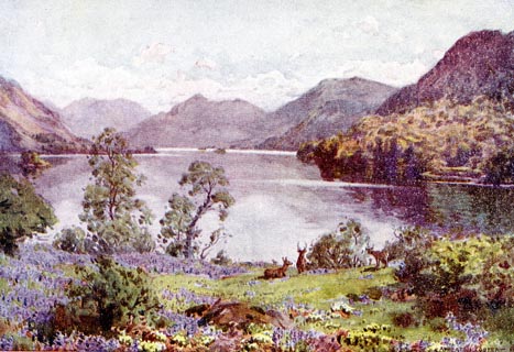 click to enlarge click to enlargeREY609.jpg "A HEATON COOPER" "ULLSWATER FROM GOWBARROW PARK." item:- JandMN : 1071.9 Image © see bottom of page |
|||||||||||||
|
|
||||||||||||||
| hearsay:- |
Dorothy Wordsworth wrote in her journal, 15 April 1802:- |
|||||||||||||
| "When we were in the woods beyond Gowbarrow Park we saw a few daffodils close to the
water side. We fancied that the lake had floated the seeds ashore and that the little
colony had so sprung up. But as we went along ther were more and yet more; and, at
last, under the boughs of the trees, we saw that there was a long belt of them along
the shore, about the breadth of a country turnpike road. I never saw daffodils so
beautiful. They grew among the mossy stones about and about them; some rested their
heads upon these stones as on a pillow for weariness; and the rest tossed and reeled
and danced, and seemed as if they verily laughed with the wind, that blew upon them
over tha lake; they looked so gay, ever glancing, ever changing. The wind blew directly
over the lake to them. There was here and there a little knot, and a few stragglers
a few yards higher up; but they were so few as not to disturb the simplicity, unity,
and life of that one busy highway. ..." |
||||||||||||||
|
|
||||||||||||||
| hearsay:- |
Heineken, brewers, came here 20 April 1982, to film an action replay of Dorothy and
William Wordsworth and the daffodils for their advertising campaign |
|||||||||||||
| "Heniken refreshes the parts other beers cannot reach." |
||||||||||||||
| Alas, no wind and no daffodils; after an exceptionally cold winter the daffs have
failed. 6000 dafodils were ordered, and arrived in two enormous lorries ... |
||||||||||||||
|
|
||||||||||||||
| evidence:- | old print:- Robertson 1911 placename:- Gowbarrow item:- daffodil |
|||||||||||||
| source data:- | Print, lithograph? Gowbarrow, Ullswater, from a watercolour by Arthur Tucker, published
by Chatto and Windus, London, 1911.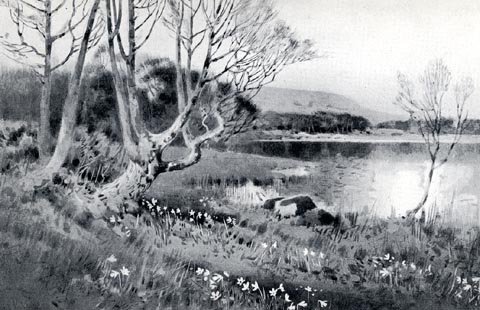 click to enlarge click to enlargeRSN142.jpg Tipped in opposite p.269 of Wordsworthshire by Eric Robertson. printed at bottom:- "GOWBARROW, ULLSWATER / (Beginning of daffodil-time)" signed at painting lower left:- "Arthur Tucker" item:- JandMN : 197.46 Image © see bottom of page |
|||||||||||||
|
|
||||||||||||||
| evidence:- | outline view:- Red Guide 1892 |
|||||||||||||
| source data:- | Print, engraving, pair of outline views, Mountains as seen from the Matterdale Road
in Gowbarrow Park, and Mountains as seen from Milking Hill, between the Inn and Blowick,
in Patterdale, published by Ward, Lock and Co, Warwick House, Salisbury Square, London,
etc, 1892.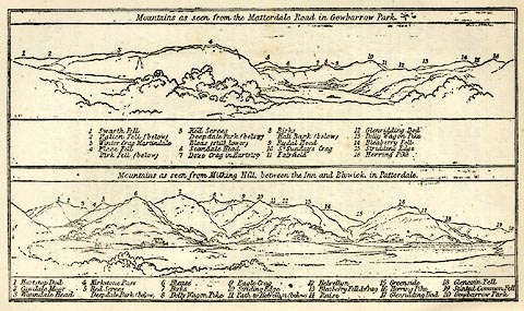 click to enlarge click to enlargeRG0106.jpg "1 Swarth Fell 2 Hallen Fell (below) 3 Winter Crag Martindale 4 Place Fell / Birk Fell (below) 5 Red Screes / Deepdale Park (below) / Bleas (still lower) 6 Scandale Head 7 Dove Crag in Hartsop 8 Birks / Hall Bank (below) 9 Rydal Head 10 St. Sunday's Crag 11 Fairfield 12 Glenridding Dod 13 Dolly Waggon Pike 14 Bleaberry Fell 15 Striding Edge 16 Herring Pike" On p.190 in the Red Guide guide book, Guide to the English Lakes. item:- JandMN : 102.7 Image © see bottom of page |
|||||||||||||
|
|
||||||||||||||
| evidence:- | outline view:- Black 1856 (23rd edn 1900) placename:- Gowbarrow Park |
|||||||||||||
| source data:- | Print, lithograph, Outline Views, Ullswater - Mountains as seen a little on the Matterdale
Road near Lyulph's Tower on Ullswater, and Mountains as seen at the Slate Quarry at
Blowick on Ullswater, by J Flintoft, Keswick, Cumberland, engraved by R Mason, Edinburgh,
Lothian, about 1900.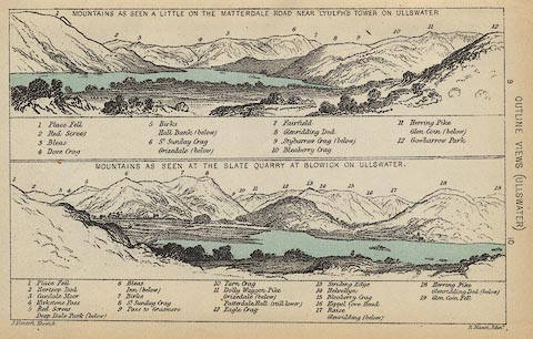 click to enlarge click to enlargeBC08E2.jpg "... 12 Gowbarrow Park ..." item:- JandMN : 37.8 Image © see bottom of page |
|||||||||||||
|
|
||||||||||||||
| evidence:- | outline view:- Black 1841 (3rd edn 1846) placename:- Gowbarrow Park |
|||||||||||||
| source data:- | Print, engraving, outline view, Mountains as seen a little on the Matterdale Road
near Lyulph's Tower on Ulleswater, and Mountains as seen at the Slate Quarry at Blowick
on Ulleswater, by J Flintoft, Keswick, Cumberland, engraved by R Mason, Edinburgh,
Lothian, about 1846.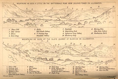 click to enlarge click to enlargeBC02E9.jpg "... 12 Gowbarrow Park ..." item:- JandMN : 32.15 Image © see bottom of page |
|||||||||||||
|
|
||||||||||||||
| evidence:- | old painting:- |
|||||||||||||
| source data:- | Painting, watercolour, Ullswater from Gowbarrow Park, Cumberland and Westmorland,
attributed to Samuel Bough, 1840s.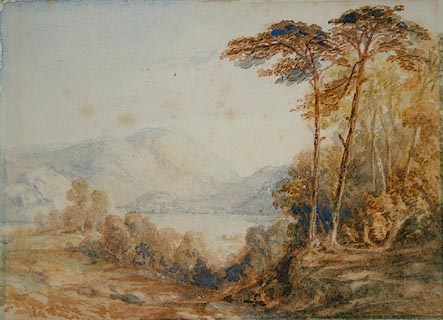 click to enlarge click to enlargePR0919.jpg Lofty autumnal trees to right of composition overlook Ullswater and distant fells. item:- Tullie House Museum : 1935.91.2.1 Image © Tullie House Museum |
|||||||||||||
|
|
||||||||||||||
| evidence:- | outline view:- Tattersall 1836 placename:- Gowbarrow Parks |
|||||||||||||
| source data:- | Print, engraving, Second Reach, Ullswater, from Place Fell, Westmorland, drawn by
George Tattersall, engraved by W F Topham, published by Sherwood and Co, Paternoster
Row, London, about 1836.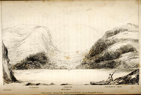 click to enlarge click to enlargeTAT141.jpg The print is captioned with mountain names and acts as an outline view. Tipped in opposite p.117 of The Lakes of England, by George Tattersall. printed at bottom:- "SECOND REACH, ULLSWATER; from PLACE FELL. / [London Pubd. ...]" printed at bottom left to right:- "Fairfield. / Stybarrow. / Helvellyn. / Glencoin. / Gowbarrow Parks." item:- Armitt Library : A1204.42 Image © see bottom of page |
|||||||||||||
|
|
||||||||||||||
| evidence:- | outline view:- placename:- Gowbarrow Parks |
|||||||||||||
| source data:- | Print, hand coloured engraving, Lower Reach, Ullswater from Pooley Bridge, Westmorland
and Cumberland, published by Sherwood and Co, London, 1836?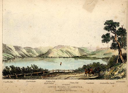 click to enlarge click to enlargePR0371.jpg Objects in the view are identified by a caption at the bottom - Swarth Fell, Martindale, High Street, Hallen Fell, Kirkstone, Place Fell, Fairfield, Gowbarrow Parks, Dumallet. printed at bottom:- "LOWER REACH, ULLSWATER. / from Pooley Bridge. / Pubd. April 15th 1836 by Sherwood &Co London." item:- Dove Cottage : 2008.107.371 Image © see bottom of page |
|||||||||||||
|
|
||||||||||||||
| evidence:- | old print:- placename:- Gowbray Park |
|||||||||||||
| source data:- | Print, aquatint, Ullswater and Gowbray Park, Cumberland, drawn by Becker, published
by R Cruttwell, Bath, Somerset, 1802.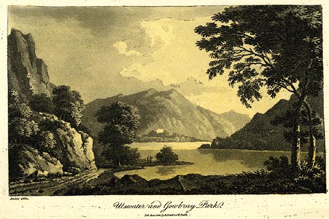 click to enlarge click to enlargePR0439.jpg A companion print has the publisher as Crutterell. printed at bottom left, centre:- "Becker del. / Ullswater and Gowbray Park. / Pub. Jan. 1 1802, by R. Cruttwell, Bath." item:- private collection : 103 Image © see bottom of page |
|||||||||||||
|
|
||||||||||||||
| hearsay:- |
It is here that William Wordsworth wrote the Host of Golden Daffodils, 1802. |
|||||||||||||
|
|
||||||||||||||
Lakes Guides menu.