 Old Cumbria Gazetteer
 |
 |
|
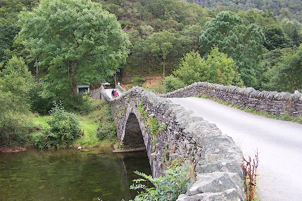
| Grange Bridge, Grange | ||
| Grange Bridge | ||
| site name:- | Derwent, River | |
| locality:- | Grange | |
| civil parish:- | Borrowdale (formerly Cumberland) | |
| county:- | Cumbria | |
| locality type:- | bridge | |
| coordinates:- | NY25371747 | |
| coordinates:- | NY25421744 | |
| 1Km square:- | NY2517 | |
| 10Km square:- | NY21 | |
|
|
||
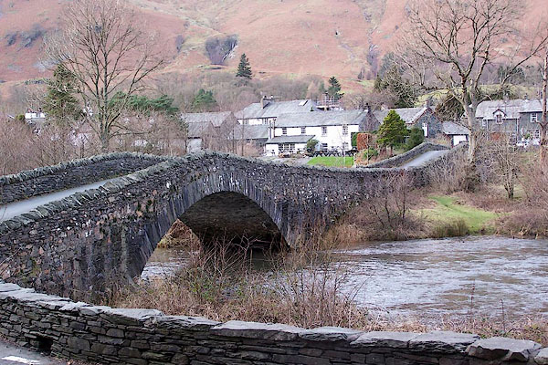 BOK55.jpg (taken 19.1.2008) 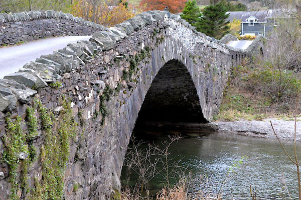 CGV58.jpg (taken 3.11.2017) |
||
|
|
||
| evidence:- | old map:- Donald 1774 (Cmd) |
|
| source data:- | Map, hand coloured engraving, 3x2 sheets, The County of Cumberland, scale about 1
inch to 1 mile, by Thomas Donald, engraved and published by Joseph Hodskinson, 29
Arundel Street, Strand, London, 1774. D4NY21NW.jpg double line across a river; a bridge item:- Carlisle Library : Map 2 Image © Carlisle Library |
|
|
|
||
| evidence:- | descriptive text:- West 1778 (11th edn 1821) |
|
| source data:- | Guide book, A Guide to the Lakes, by Thomas West, published by
William Pennington, Kendal, Cumbria once Westmorland, and in
London, 1778 to 1821. goto source goto sourceAddendum; Mr Gray's Journal, 1769 Page 205:- "... through it [at Grange] obliquely runs the Derwent, clear as glass, and showing under its bridge every trout that passes. ..." |
|
|
|
||
| evidence:- | old map:- Crosthwaite 1783-94 (Der) |
|
| source data:- | Map, uncoloured engraving, An Accurate Map of the Matchless Lake
of Derwent, ie Derwent Water, scale about 3 inches to 1 mile, by
Peter Crosthwaite, Keswick, Cumberland, 1783, version published
1800. CT2NY21M.jpg item:- Armitt Library : 1959.191.3 Image © see bottom of page |
|
|
|
||
| evidence:- | old print:- Middiman 1784-92 placename:- Grange Bridge |
|
| source data:- | Print, uncoloured engraving, View at Grange Bridge, Borrowdale, Cumberland, painted
by T Smith, engraved and published by Samuel Middiman, 3 Grafton Street, Tottenham
Court Road, London, 1784.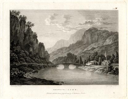 click to enlarge click to enlargeMM0201.jpg "Painted by T. Smith. / Engrav'd by S. Middiman. / KESWICK - LAKE. / Publish'd as the Act directs, July 30th. 1784, by S. Middiman, London." Accompanying text:- "PLATE V.." "VIEW at GRANGE - BRIDGE," "Near KESWICK, in CUMBERLAND." "THE Scene here represented, at Grange-Bridge, lies not far distant from where the River Derwent makes its rapid Influx to the Lake of Keswick." "The Village of Grange is seated on the western Side of this River, directly fronting a stupendous Precipice, broken and wildly irregular, covered on its Summit entirely with old Trees, here and there discovering the white prominent Rocks through the Apertures of the Wood." "Behind the Village, Part of Bleaberry Crag is seen, so called from producing large Quantities of Bilberries, here called Bleaberries, that grow wild upon the Moors in these Parts." "Farther to the left, Gate Crag rises to an astonishing Height, backed by Linning Crag and Castle Hose, that exhibits a vast Range of Mountain, descending in the most agreeable Perspective." "At the Turn of the Road on the left, Castle Crag comes in Sight, bearing on its Summit some Traces of a Fort, probably of Roman origin, intended to guard the Pass, and secure the Treasure contained in the Bosom of these Mountains.*" "Below Grange is a Salt Spring, which formerly belonged to the Monks of Furness, the Vestiges of whose Works are still remaining." "* Guide to the lakes." item:- Armitt Library : A6859.1 Image © see bottom of page |
|
|
|
||
| evidence:- | old text:- Clarke 1787 |
|
| source data:- | Guide book, A Survey of the Lakes of Cumberland, Westmorland,
and Lancashire, written and published by James Clarke, Penrith,
Cumberland, and in London etc, 1787; published 1787-93. goto source Page 82:- "... to Borrowdale Grainge, over a bad stone bridge, built in 1678. The river is navigable hither, when the water is pretty high, for boats, which carry down blue slate, wood, charcoal, oak, bark, lead-ore, &c. to Crow Park, or Transhag-End." |
|
|
|
||
| evidence:- | old map:- Clarke 1787 map (Der) placename:- |
|
| source data:- | Map, uncoloured engraving, Map of Derwentwater and its Environs,
scale about 13 ins to 1 mile, by James Clarke, engraved by S J
Neele, published by James Clarke, Penrith, Cumberland and in
London etc, 1787.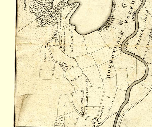 CL152518.jpg road bridge over the Derwent item:- private collection : 169 Image © see bottom of page |
|
|
|
||
| evidence:- | old print:- Farington 1789 |
|
| source data:- | Print, uncoloured engraving, The Grange, in Borrowdale, Cumberland, drawn by Joseph
Farington, engraved by W Byrne and T Medland, published by William Byrne, 79 Titchfield
Street, London, 1784.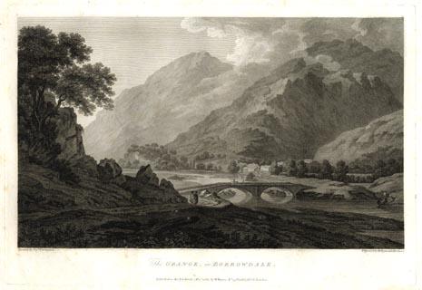 click to enlarge click to enlargeFA0302.jpg printed, bottom left, right, centre "Drawn by Josh. Farington / Engraved by W. Byrne &T. Medland / The GRANGE, in BORROWDALE. / Published as the Act directs, 1 Decr. 1784, by W. Byrne, No.79, Titchfield Str. London." item:- Armitt Library : A6668.2 Image © see bottom of page |
|
|
|
||
| evidence:- | old print with text:- Farington 1816 placename:- Grange Bridge |
|
| source data:- | Print, uncoloured engraving and descriptive text, The Grange in Borrowdale, Cumberland,
drawn by Joseph Farington, engraved by J Scott, published by T Cadell and W Davies,
Strand, London, 1815.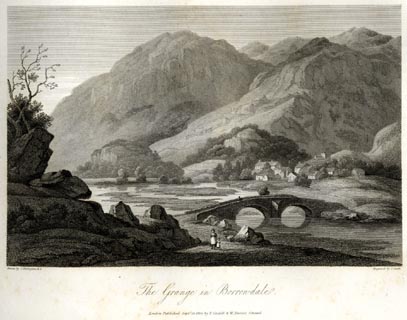 click to enlarge click to enlargeFA0407.jpg printed, bottom left, right, centre "Drawn by J. Farington R.A. / Engraved by J. Scott. / Grange in Borrowdale. / London Published Septr. 15, 1815, by T. Cadell &W. Davies, Strand." Descriptive text:- "... The river Derwent, clear, shallow, and melodious, washes the stone bank on which the greater number of the pines grow, and forms the fore-ground, with an old bridge of two arches, as rude in construction as the cottages. ..." item:- Armitt Library : A6666.7 Image © see bottom of page |
|
|
|
||
| evidence:- | old drawing:- Aspland 1840s-60s |
|
| source data:- | Drawing, pencil, Grange Bridge, Grange, Borrowdale, Cumberland, by Theophilus Lindsey
Aspland, 1857.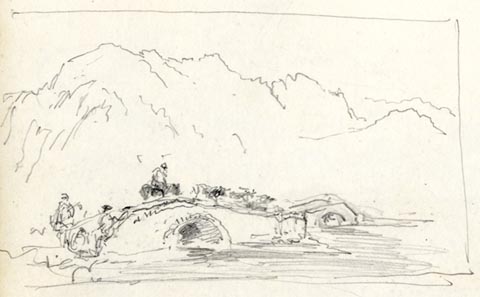 click to enlarge click to enlargeAS0532.jpg item:- Armitt Library : 1958.389.32 Image © see bottom of page |
|
|
|
||
| evidence:- | old photograph:- Bell 1880s-1940s |
|
| source data:- | Photograph, sepia, Grange Bridge, Grange, Borrowdale, Cumberland, by Herbert Bell,
Ambleside, Westmorland, 1890s.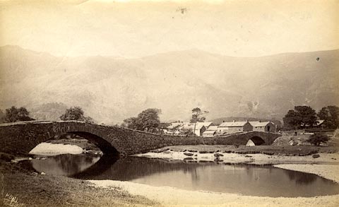 click to enlarge click to enlargeHB0384.jpg internegative at lower left:- "H. Bell" item:- Armitt Library : ALPS38 Image © see bottom of page |
|
|
|
||
| evidence:- | old print:- Bradley 1901 |
|
| source data:- | Print, uncoloured lithograph, The Bridge at Grange, Borrowdale, Cumberland, by Joseph
Pennell, published by Macmillan and Co, London, 1901.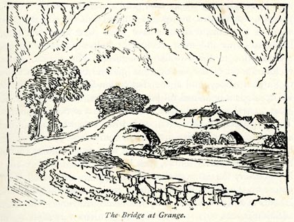 click to enlarge click to enlargeBRL126.jpg On page 125 of Highways and Byways in the Lake District, by A G Bradley. printed at bottom:- "The Bridge at Grange." item:- JandMN : 464.26 Image © see bottom of page |
|
|
|
||
| evidence:- | old print:- Heaton Cooper 1905 (edn 1908) item:- fishing |
|
| source data:- | Print, colour halftone, Grange in Borrowdale, early morning, Borrowdale, Cumberland,
from a watercolour painting by Alfred Heaton Cooper, published by Adam and Charles
Black, London, 2nd edn 1908.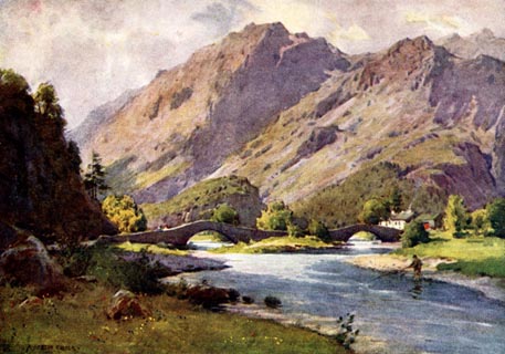 click to enlarge click to enlargeHC0149.jpg Looking at Grange Bridge. Opposite p.144 of The English Lakes, painted by Alfred Heaton Cooper, described by William T Palmer. printed at tissue opposite the print:- "GRANGE IN BORROWDALE / Early morning" printed at signed lower left:- "[A HEATON COOPER]" item:- JandMN : 468.49 Image © see bottom of page |
|
|
|
||
| evidence:- | database:- Listed Buildings 2010 placename:- Grange Bridge |
|
| source data:- | courtesy of English Heritage "GRANGE BRIDGE / / / BORROWDALE / ALLERDALE / CUMBRIA / II / 72133 / NY2540017461" |
|
| source data:- | courtesy of English Heritage "Roadbridge. Rebuilt early C19. Slate rubble. Double continuous bridge over twin arms of the River Derwent. Both of single width and single span with humped backs. Arches have thin slate voussoirs under solid parapet with rubble coping." |
|
|
|
||
| evidence:- | old print:- Rose 1832-35 |
|
| source data:- | Print, engraving, Derwentwater and Village of Grange, from the Entrance to Borrowdale,
by Thomas Allom, engraved by W le Petit, 1833.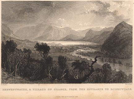 click to enlarge click to enlargeR208.jpg "Derwentwater and the Village of Grange, from the Entrance to Borrowdale" item:- JandMN : 96.5 Image © see bottom of page |
|
|
|
||
| evidence:- | old print:- placename:- Grange Bridge |
|
| source data:- | Print, uncoloured engraving, Grange Bridge, Entrance to Borrowdale, Cumberland, published
1830s-40s?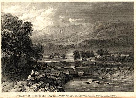 click to enlarge click to enlargePR0576.jpg printed at bottom:- "GRANGE BRIDGE, ENTRANCE TO BORROWDALE, CUMBERLAND" item:- Dove Cottage : 2008.107.524 Image © see bottom of page |
|
|
|
||
| evidence:- | old print:- Farington 1789 (plate 2) |
|
| source data:- | Print, engraving, The Grange in Borrowdale, painted by Joseph Farington, engraved
by W Byrne and T Medland, published by W Byrne, 79 Titchfield Street, London, 1784.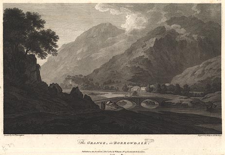 click to enlarge click to enlargeBMZ90.jpg Grange Bridge over the River Derwent, Grange village and Low Scawdel and High Scawdel in the background? Plate 2 from Views of the Lakes, &c, in Cumberland and Westmorland, published 1789. item:- Dove Cottage : Lowther.54 Image © see bottom of page |
|
|
|
||
| evidence:- | old print:- Middiman 1784-92 (pl.2) |
|
| source data:- | Print, uncoloured engraving, Keswick Lake, Cumberland, drawn by J Smith, engraved
and published by Samuel Middiman, London, 1784.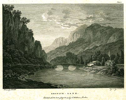 click to enlarge click to enlargePR0193.jpg The view is of Grange Bridge, Borrowdale, on the River Derwent, not the lake; and is not a true picture of the double bridge Plate 2 in a set of prints, part 1, Select Views in Great Britain. printed at bottom left, right, centre:- "Drawn by J. Smith. / Engrav'd by S. Middiman. / KESWICK - LAKE. / Published as the Act directs, July 30th. 1784, by S. Middiman, London." printed at top right:- "Plate 2." item:- Dove Cottage : 2008.107.193 Image © see bottom of page |
|
|
|
||
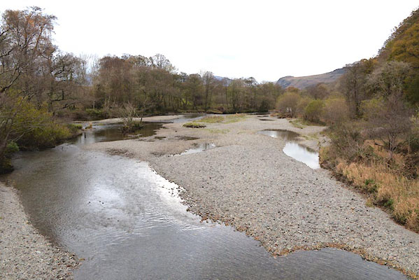 CGV59.jpg View of river. (taken 3.11.2017) |
||
|
|
||
 BJV77.jpg (taken 18.9.2005) |
||
|
|
||
| hearsay:- |
The bridge was built in 1675. Boats carried slate and wood from here, down the River
Derwent to the foot of Derwent Water. |
|
|
|
||
Lakes Guides menu.