 Old Cumbria Gazetteer
 |
 |
|
| Greta Bridge, Keswick | ||
| Greta Bridge | ||
| site name:- | Greta, River | |
| locality:- | Keswick | |
| civil parish:- | Keswick (formerly Cumberland) | |
| county:- | Cumbria | |
| locality type:- | bridge | |
| coordinates:- | NY26302374 | |
| 1Km square:- | NY2623 | |
| 10Km square:- | NY22 | |
|
|
||
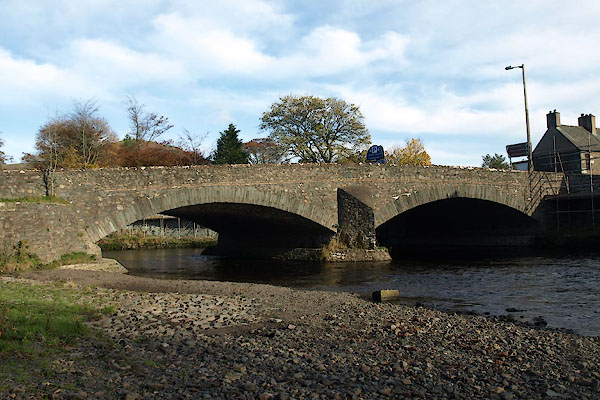 BVP87.jpg (taken 5.11.2011) 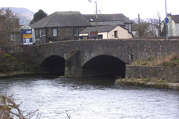 BLT77.jpg (taken 3.4.2006) |
||
|
|
||
| evidence:- | old map:- OS County Series (Cmd 64 2) placename:- Greta Bridge |
|
| source data:- | Maps, County Series maps of Great Britain, scales 6 and 25
inches to 1 mile, published by the Ordnance Survey, Southampton,
Hampshire, from about 1863 to 1948. |
|
|
|
||
| evidence:- | probably old map:- Saxton 1579 |
|
| source data:- | Map, hand coloured engraving, Westmorlandiae et Cumberlandiae Comitatus ie Westmorland
and Cumberland, scale about 5 miles to 1 inch, by Christopher Saxton, London, engraved
by Augustinus Ryther, 1576, published 1579-1645.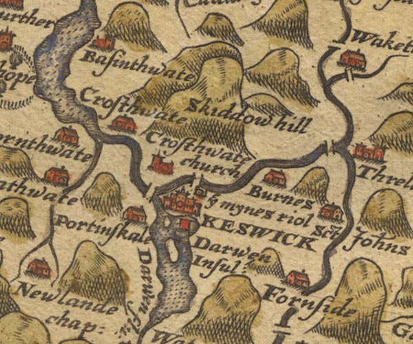 Sax9NY22.jpg N of Keswick. item:- private collection : 2 Image © see bottom of page |
|
|
|
||
| evidence:- | old map:- Mercator 1595 (edn?) placename:- |
|
| source data:- | Map, hand coloured engraving, Northumbria, Cumberlandia, et
Dunelmensis Episcopatus, ie Northumberland, Cumberland and
Durham etc, scale about 6.5 miles to 1 inch, by Gerard Mercator,
Duisberg, Germany, about 1595.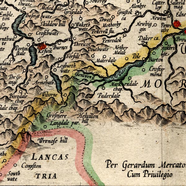 MER8CumF.jpg "" double across a stream; bridge, over the Greta item:- JandMN : 169 Image © see bottom of page |
|
|
|
||
| evidence:- | probably old map:- Speed 1611 (Cmd) |
|
| source data:- | Map, hand coloured engraving, Cumberland and the Ancient Citie
Carlile Described, scale about 4 miles to 1 inch, by John Speed,
1610, published by J Sudbury and George Humble, Popes Head
Alley, London, 1611-12.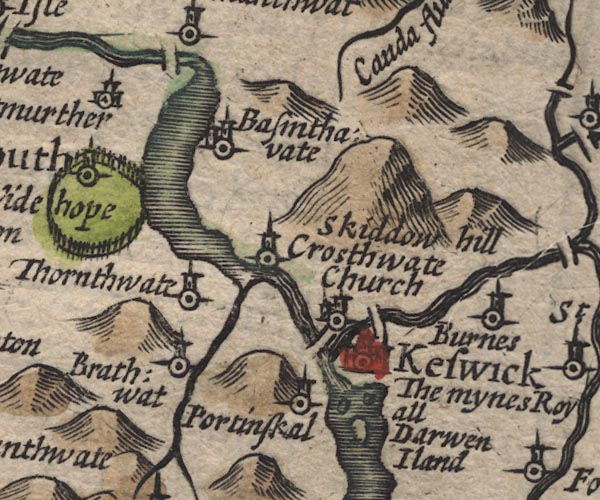 SP11NY22.jpg double line across the Greta item:- private collection : 16 Image © see bottom of page |
|
|
|
||
| evidence:- | old map:- Jansson 1646 |
|
| source data:- | Map, hand coloured engraving, Cumbria and Westmoria, ie
Cumberland and Westmorland, scale about 3.5 miles to 1 inch, by
John Jansson, Amsterdam, Netherlands, 1646.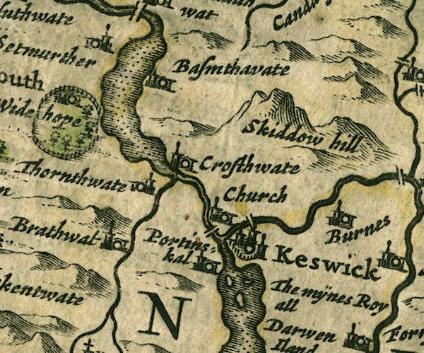 JAN3NY22.jpg Double line crossing the stream. item:- JandMN : 88 Image © see bottom of page |
|
|
|
||
| evidence:- | old map:- Ogilby 1675 (plate 96) |
|
| source data:- | Road strip map, hand coloured engraving, the Road from Kendal to
Cockermouth, and the Road from Egremond to Carlisle, scale about
1 inch to 1 mile, by John Ogilby, London, 1675.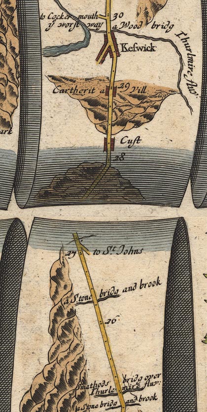 OG96m025.jpg In mile 29, Cumberland. "a Wood bridg" over "Thurlmire fluv:" No bridge drawn. item:- JandMN : 22 Image © see bottom of page |
|
|
|
||
| evidence:- | old map:- Sanson 1679 |
|
| source data:- | Map, hand coloured engraving, Ancien Royaume de Northumberland
aujourdhuy Provinces de Nort, ie the Ancient Kingdom of
Northumberland or the Northern Provinces, scale about 9.5 miles
to 1 inch, by Nicholas Sanson, Paris, France, 1679. click to enlarge click to enlargeSAN2Cm.jpg double line over a stream; bridge item:- Dove Cottage : 2007.38.15 Image © see bottom of page |
|
|
|
||
| evidence:- | old map:- Seller 1694 (Cmd) |
|
| source data:- | Map, uncoloured engraving, Cumberland, scale about 12 miles to 1
inch, by John Seller, 1694. click to enlarge click to enlargeSEL9.jpg two lines cross a stream; bridge item:- Dove Cottage : 2007.38.89 Image © see bottom of page |
|
|
|
||
| evidence:- | probably old map:- Morden 1695 (Cmd) |
|
| source data:- | Map, uncoloured engraving, Cumberland, scale about 4 miles to 1
inch, by Robert Morden, 1695, published by Abel Swale, the
Unicorn, St Paul's Churchyard, Awnsham, and John Churchill, the
Black Swan, Paternoster Row, London, 1695-1715.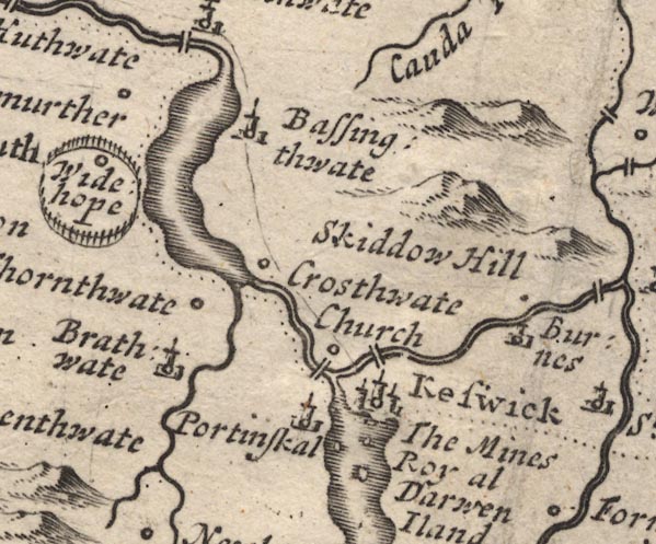 MD12NY22.jpg Double line over the Greta at Keswick. item:- JandMN : 90 Image © see bottom of page |
|
|
|
||
| evidence:- | old map:- Bowen 1720 (plate 260) |
|
| source data:- | Road strip map, uncoloured engraving, pl.260, The Road from
Kendal to Cockermouth, scale about 2 miles to 1 inch, with
sections in Westmorland and Cumberland, published by Emanuel
Bowen, St Katherines, London, 1720.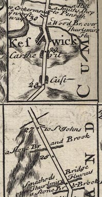 B260m25.jpg "a Wood Br. over Thurlemire Flu" On far side of Keswick. item:- private collection : 1.260 Image © see bottom of page |
|
|
|
||
| evidence:- | old map:- Badeslade 1742 placename:- |
|
| source data:- | Map, uncoloured engraving, A Map of Cumberland North from
London, scale about 11 miles to 1 inch, with descriptive text,
by Thomas Badeslade, London, engraved and published by William
Henry Toms, Union Court, Holborn, London, 1742. click to enlarge click to enlargeBD10.jpg "" double line across a stream item:- JandMN : 115 Image © see bottom of page |
|
|
|
||
| evidence:- | old map:- Gents Mag 1751 |
|
| source data:- | Map, uncoloured engraving, Map of the Black Lead Mines in
Cumberland, and area, scale about 2 miles to 1 inch, by George
Smith, published in the Gentleman's Magazine, 1751.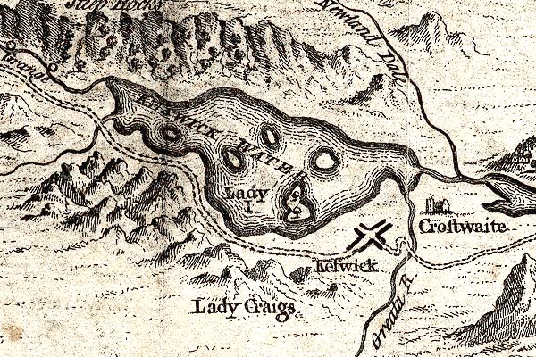 GM1311.jpg bridge item:- JandMN : 114 Image © see bottom of page |
|
|
|
||
| evidence:- | old map:- Bowen and Kitchin 1760 |
|
| source data:- | Map, hand coloured engraving, A New Map of the Counties of
Cumberland and Westmoreland Divided into their Respective Wards,
scale about 4 miles to 1 inch, by Emanuel Bowen and Thomas
Kitchin et al, published by T Bowles, Robert Sayer, and John
Bowles, London, 1760. BO18NY21.jpg double line across the Derwent item:- Armitt Library : 2008.14.10 Image © see bottom of page |
|
|
|
||
| evidence:- | old map:- Donald 1774 (Cmd) |
|
| source data:- | Map, hand coloured engraving, 3x2 sheets, The County of Cumberland, scale about 1
inch to 1 mile, by Thomas Donald, engraved and published by Joseph Hodskinson, 29
Arundel Street, Strand, London, 1774. D4NY22SE.jpg double line across a river; a bridge over the Greta in Keswick item:- Carlisle Library : Map 2 Image © Carlisle Library |
|
|
|
||
| evidence:- | old map:- Clarke 1787 map (Der) placename:- |
|
| source data:- | Map, uncoloured engraving, Map of Derwentwater and its Environs,
scale about 13 ins to 1 mile, by James Clarke, engraved by S J
Neele, published by James Clarke, Penrith, Cumberland and in
London etc, 1787.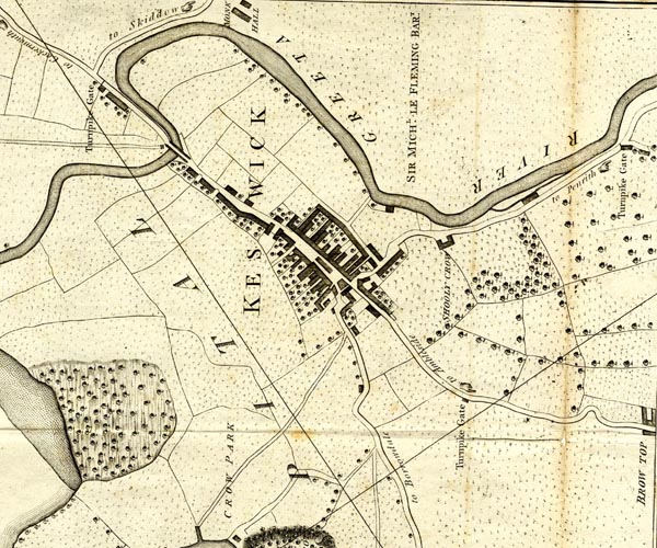 CL152623.jpg road across the Greta item:- private collection : 169 Image © see bottom of page |
|
|
|
||
| evidence:- | old print:- Farington 1789 |
|
| source data:- | Print, uncoloured engraving, North Entrance to Keswick, Cumberland, drawn by Joseph
Farington, engraved by W Byrne and T Medland, published by William Byrne, 79 Titchfield
Street, London, 1787.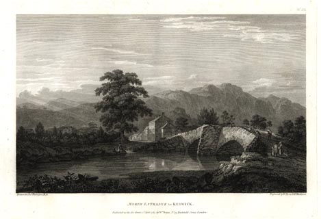 click to enlarge click to enlargeFA0309.jpg printed, top right "No.IX" printed, bottom left, right, centre "Drawn by Josh. Farington R.A. / Engraved by W. Byrne &T. Medland. / NORTH ENTRANCE to KESWICK. / Published as the Act directs, 2d. April 1787, by W. Byrne, No.79, Titchfield Street, London." item:- Armitt Library : A6668.9 Image © see bottom of page |
|
|
|
||
| evidence:- | old map:- Otley 1818 |
|
| source data:- | Map, uncoloured engraving, The District of the Lakes,
Cumberland, Westmorland, and Lancashire, scale about 4 miles to
1 inch, by Jonathan Otley, 1818, engraved by J and G Menzies,
Edinburgh, Scotland, published by Jonathan Otley, Keswick,
Cumberland, et al, 1833.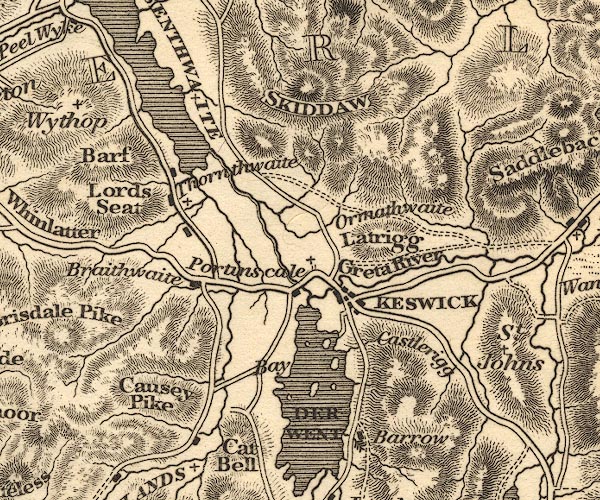 OT02NY22.jpg Implied by a road across the stream. item:- JandMN : 48.1 Image © see bottom of page |
|
|
|
||
| evidence:- | old print:- Westall 1820 placename:- Keswick Bridge |
|
| source data:- | Print, uncoloured mezzotint, Keswick Bridge, over the River Greta, Cumberland, drawn
and engraved by William Westall, published by Rodwell and Martin, New Bond Street,
London, 1820.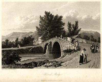 click to enlarge click to enlargeWTL104.jpg printed, bottom left, centre "Drawn & Engraved by W. Westall A.R.A. / Keswick Bridge. / Published April 1, 1820, by Hurst, Robinson &Co. Cheapside." item:- Armitt Library : A6671.4 Image © see bottom of page |
|
|
|
||
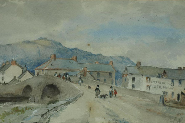
| evidence:- | old photograph:- Bell 1880s-1940s item:- horses |
|
| source data:- | Photograph, sepia, Greta Bridge, River Greta, Keswick, Cumberland, by Herbert Bell,
photographer, Ambleside, Westmorland, 1890s.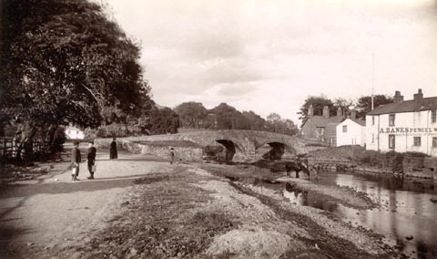 click to enlarge click to enlargeHB0620.jpg Ann Banks, Greta Bridge pencil works, on the right. item:- Armitt Library : ALPS280 Image © see bottom of page |
|
|
|
||
| evidence:- | old print:- Bemrose 1881 placename:- Greta Bridge |
|
| source data:- | Print, uncoloured, Greta Bridge, Keswick, Cumberland, published by Bemrose and Sons,
23 Old Bailey, London and Derby, by A B Moss, Carlisle, Cumberland, and by T Wilson,
Kendal, Westmorland, about 1881.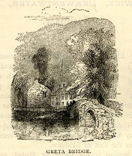 click to enlarge click to enlargeBEM119.jpg On p.68 of a Handy Guide to the English Lakes and Shap Spa. printed at bottom:- "GRETA BRIDGE" item:- JandMN : 455.21 Image © see bottom of page |
|
|
|
||
| evidence:- | old print:- Philip/Wilson 1890s |
|
| source data:- | Print, engraving, Greta Bridge, Keswick, published by George
Philip and Son, London, Philip, Son and Nephew, Liverpool,
Lancashire, and Titus Wilson, Kendal, Westmorland, about 1895.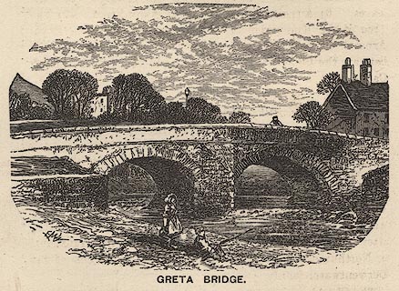 click to enlarge click to enlargePW1E26.jpg "GRETA BRIDGE." item:- JandMN : 58.27 Image © see bottom of page |
|
|
|
||
| evidence:- | old map:- Bell 1892 placename:- Greta Bridge |
|
| source data:- | Map, colour lithograph, Road Map of Cumberland, by George Joseph
Bell, scale about 2.5 miles to 1 inch, printed by Charles
Thurnam and Sons, Carlisle, Cumberland, 1892. BEL9NY22.jpg "GRETA" bridge symbol Road map of Cumberland showing County Bridges item:- Carlisle Library : Map 38 Image © Carlisle Library |
|
|
|
||
| evidence:- | old print:- Sylvan 1847 placename:- Greta Bridge |
|
| source data:- | Print, engraving, Keswick from Greta Bridge, Cumberland, published by John Johnstone,
Paternoster Row, London, et al, 1847.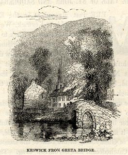 click to enlarge click to enlargeSYL143.jpg On p.181 of Sylvan's Pictorial Guide to the English Lakes. printed at bottom:- "KESWICK FROM GRETA BRIDGE." item:- Armitt Library : A1201.43 Image © see bottom of page |
|
|
|
||
| evidence:- | old print:- Heywood 1906 placename:- Greta Bridge |
|
| source data:- | Print, engraving, Greta Bridge, Keswick, Cumberland, drawn by EMW, published by Abel
Heywood and Son, 56-58 Oldham Street, Manchester, and by Simpkin, Marshall, Hamilton,
Kent and Co, Ave Maria Lane, Paternoster Row, London, 1906.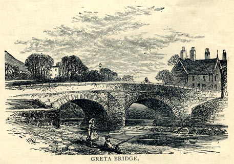 click to enlarge click to enlargeHW1E04.jpg In a Guide to Keswick and its Vicinity in the Penny Guide Books series. printed at bottom:- "GRETA BRIDGE," printed at lower left:- "EMW" item:- JandMN : 348.4 Image © see bottom of page |
|
|
|
||
| evidence:- | old print:- item:- road |
|
| source data:- | Print, uncoloured engraving, Bridge over the Greta, Keswick, Cumberland, by ?B Foster,
engraved by E Evans, 1850s-60s?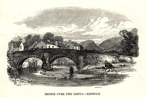 click to enlarge click to enlargePR0494.jpg printed at bottom left, right, centre:- "[B] Foster / E. EVANS SC. / BRIDGE OVER THE GRETA - KESWICK" item:- Dove Cottage : 2008.107.443 Image © see bottom of page |
|
|
|
||
| evidence:- | old print:- Harwood 1842 placename:- Keswick Bridge |
|
| source data:- | Print, uncoloured engraving, Greta Hall and Keswick Bridge, Cumberland, drawn by W
Westall, engraved by E. Franis, published by John and Frederick Harwood, 26 Fenchurch
Street, London, about 1842.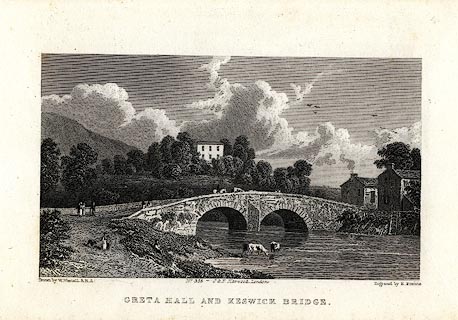 click to enlarge click to enlargeHRW213.jpg printed at bottom left, right, centre:- "Drawn by W. Wstall, A.R.A. / Ebngraved by E. Francis. / No.355 - J. &F. Harwood, London. / GRETA HALL AND KESWICK BRIDGE." item:- JandMN : 166.13 Image © see bottom of page |
|
|
|
||
| evidence:- | old print:- Rose 1832-35 (vol.1 no.44) placename:- Greta Bridge |
|
| source data:- | Print, uncoloured engraving, Keswick, from Greta Bridge, Cumberland, drawn by H Gastineau,
engraved by W le Petit, published by Fisher, Son and Co, London, 1833.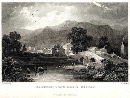 click to enlarge click to enlargePR0018.jpg vol.1 pl.44 in the set of prints, Westmorland, Cumberland, Durham and Northumberland Illustrated. printed at bottom left, right, centre:- "H. Gastineau. / W Le Petit. / KESWICK, FROM GRETA BRIDGE. / FISHER, SON &CO. LONDON, 1833." item:- Dove Cottage : 2008.107.18 Image © see bottom of page |
|
|
|
||
| evidence:- | old print:- placename:- Keswick Bridge |
|
| source data:- | Print, uncoloured engraving, Greta Hall and Keswick Bridge, Cumberland, drawn by W
Westall, engraved by E Francis, about 1830s?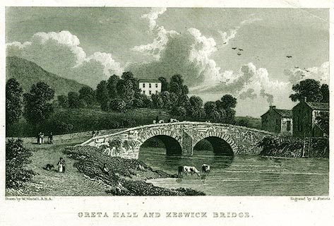 click to enlarge click to enlargePR0151.jpg printed at bottom left, right, centre:- "Drawn by W. Westall, A.R.A. / Engraved by E. Francis. / GRETA HALL AND KESWICK BRIDGE." item:- Dove Cottage : 2008.107.151 Image © see bottom of page |
|
|
|
||
| evidence:- | old print:- Cooke c1827 |
|
| source data:- | Print, engraving, North Entrance to Keswick, Cumberland, engraved by J and H S Storer,
published by Sherwood, Jones and Co, Paternoster Row, London, about 1827?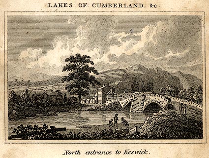 click to enlarge click to enlargeCOK7E3.jpg Part of the frontispiece to The Tourist's and Traveller's Companion to the Lakes, by Charles Cooke. printed at top:- "LAKES OF CUMBERLAND, &c." printed at bottom:- "North entrance to Keswick." item:- Armitt Library : A1121.3 Image © see bottom of page |
|
|
|
||
| evidence:- | old print with text:- Farington 1789 (plate 9) |
|
| source data:- | Print, engraving, North Entrance to Keswick, painted by Joseph Farington, engraved
by W Byrne and T Medland, published by W Byrne, 79 Titchfield Street, London, 1787.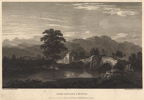 click to enlarge click to enlargeBMZ88.jpg Greta Bridge and the River Greta. Plate 9 from Views of the Lakes, &c, in Cumberland and Westmorland, published 1789. "... The bridge in the foreground is over the Greata, which joins the Derwent a little below in it's course from Derwent to Bassenthwaite-water. ... It ought to be observed here, as it was done before with respect to the timber and coppice-woods, that the bridges in this country are liable to perpetual alterations on account of the violence of the torrents; it is not therefore to be wondered at if the representation given of them should sometimes vary from the present form." item:- Dove Cottage : Lowther.52 Image © see bottom of page |
|
|
|
||
 BUF91.jpg courtesy of Keswick Museum. |
||
|
|
||
 Lakes Guides menu.