 Old Cumbria Gazetteer
 |
 |
|
| Hartsop Hall, Patterdale | ||
| Hartsop Hall | ||
| locality:- | Hartsop (area) | |
| civil parish:- | Patterdale (formerly Westmorland) | |
| county:- | Cumbria | |
| locality type:- | buildings | |
| coordinates:- | NY39831204 | |
| 1Km square:- | NY3912 | |
| 10Km square:- | NY31 | |
|
|
||
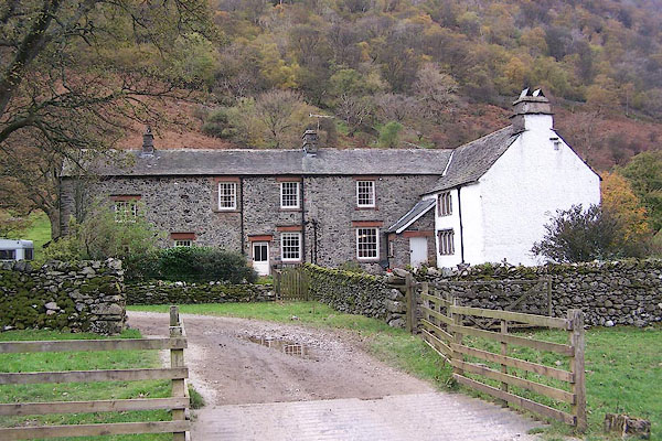 BMY56.jpg (taken 5.11.2006) 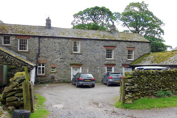 CAS18.jpg (taken 21.5.2014) |
||
|
|
||
| evidence:- | old map:- OS County Series (Wmd 19 7) placename:- Hartsop Hall |
|
| source data:- | Maps, County Series maps of Great Britain, scales 6 and 25
inches to 1 mile, published by the Ordnance Survey, Southampton,
Hampshire, from about 1863 to 1948. |
|
|
|
||
| evidence:- | old map:- Saxton 1579 placename:- Harteshope Hall |
|
| source data:- | Map, hand coloured engraving, Westmorlandiae et Cumberlandiae Comitatus ie Westmorland
and Cumberland, scale about 5 miles to 1 inch, by Christopher Saxton, London, engraved
by Augustinus Ryther, 1576, published 1579-1645.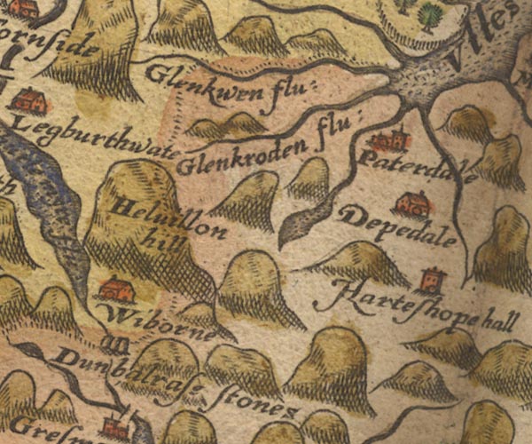 Sax9NY31.jpg Tower, symbol for a house, hall, tower, etc. "Harteshope hall" item:- private collection : 2 Image © see bottom of page |
|
|
|
||
| evidence:- | old map:- Speed 1611 (Wmd) placename:- Harteshope hall |
|
| source data:- | Map, hand coloured engraving, The Countie Westmorland and
Kendale the Cheif Towne, scale about 2.5 miles to 1 inch, by
John Speed, 1610, published by George Humble, Popes Head Alley,
London, 1611-12.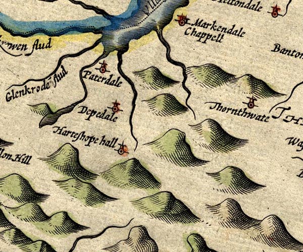 SP14NY41.jpg "Harteshope hall" circle, tower item:- Armitt Library : 2008.14.5 Image © see bottom of page |
|
|
|
||
| evidence:- | table of distances:- Simons 1635 placename:- Harteshop Hall |
|
| source data:- | Table of distances, uncoloured engraving, Westmerland ie
Westmorland, with a thumbnail map, scale about 42 miles to 1
inch, by Mathew Simons, published in A Direction for the English
Traviller, 1635.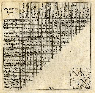 click to enlarge click to enlargeSIM3.jpg "Harteshop Hall N" and tabulated distances item:- private collection : 50.39 Image © see bottom of page |
|
|
|
||
| evidence:- | probably old map:- Jansson 1646 placename:- Harteshope Hall |
|
| source data:- | Map, hand coloured engraving, Cumbria and Westmoria, ie
Cumberland and Westmorland, scale about 3.5 miles to 1 inch, by
John Jansson, Amsterdam, Netherlands, 1646.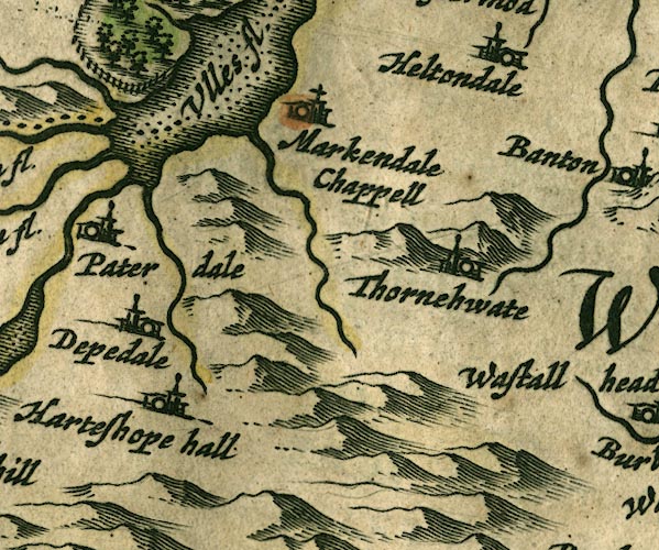 JAN3NY41.jpg "Harteshope hall" Buildings and tower. item:- JandMN : 88 Image © see bottom of page |
|
|
|
||
| evidence:- | old map:- Seller 1694 (Wmd) placename:- Harteshope Hall |
|
| source data:- | Map, hand coloured engraving, Westmorland, scale about 8 miles
to 1 inch, by John Seller, 1694. click to enlarge click to enlargeSEL7.jpg "Harteshope hall" circle, italic lowercase text; settlement or house item:- Dove Cottage : 2007.38.87 Image © see bottom of page |
|
|
|
||
| evidence:- | old map:- Morden 1695 (Wmd) placename:- Hartshop Hall |
|
| source data:- | Map, hand coloured engraving, Westmorland, scale about 2.5 miles to 1 inch, by Robert
Morden, published by Abel Swale, the Unicorn, St Paul's Churchyard, Awnsham, and John
Churchill, the Black Swan, Paternoster Row, London, 1695.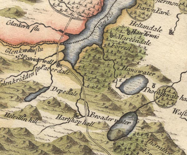 MD10NY41.jpg "Hartshop hall" Circle, building and tower. item:- JandMN : 24 Image © see bottom of page |
|
|
|
||
| evidence:- | old map:- Badeslade 1742 placename:- Hartsop Hall |
|
| source data:- | Map, uncoloured engraving, A Map of Westmorland North from
London, scale about 10 miles to 1 inch, with descriptive text,
by Thomas Badeslade, London, engraved and published by William
Henry Toms, Union Court, Holborn, London, 1742. click to enlarge click to enlargeBD12.jpg "Hartsop Hall" circle, italic lowercase text; village, hamlet or locality item:- Dove Cottage : 2007.38.62 Image © see bottom of page |
|
|
|
||
| evidence:- | old map:- Simpson 1746 map (Wmd) placename:- Hartshop Hall |
|
| source data:- | Map, uncoloured engraving, Westmorland, scale about 8 miles to 1
inch, printed by R Walker, Fleet Lane, London, 1746.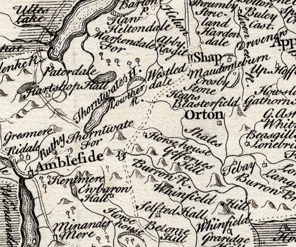 SMP2NYK.jpg "Hartshop Hall" Building; and outline of park. item:- Dove Cottage : 2007.38.59 Image © see bottom of page |
|
|
|
||
| evidence:- | old map:- Bowen and Kitchin 1760 placename:- Hartshop Hall |
|
| source data:- | Map, hand coloured engraving, A New Map of the Counties of
Cumberland and Westmoreland Divided into their Respective Wards,
scale about 4 miles to 1 inch, by Emanuel Bowen and Thomas
Kitchin et al, published by T Bowles, Robert Sayer, and John
Bowles, London, 1760.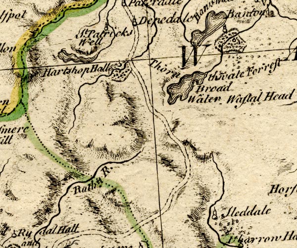 BO18NY30.jpg "Hartshop Hall" circle and line, and outline of fence palings, bushes, for a park item:- Armitt Library : 2008.14.10 Image © see bottom of page |
|
|
|
||
| evidence:- | old map:- Jefferys 1770 (Wmd) placename:- Hartsop Hall |
|
| source data:- | Map, 4 sheets, The County of Westmoreland, scale 1 inch to 1
mile, surveyed 1768, and engraved and published by Thomas
Jefferys, London, 1770.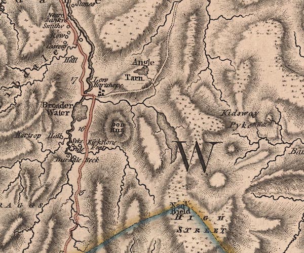 J5NY41SW.jpg "Hartsop Hall" circle, labelled in italic lowercase text; settlement, farm, house, or hamlet? item:- National Library of Scotland : EME.s.47 Image © National Library of Scotland |
|
|
|
||
| evidence:- | old text:- Green 1814 placename:- Hartsope Hall |
|
| source data:- | Set of prints, soft ground etchings, Sixty Small Prints, with
text, A Description of a Series of Sixty Small Prints, by
William Green, Ambleside, Westmorland, 1814. goto source goto sourcepage 28:- "... Hartsope Hall (a picturesque old farm-house) ..." |
|
|
|
||
| evidence:- | descriptive text:- Ford 1839 (3rd edn 1843) |
|
| source data:- | Guide book, A Description of Scenery in the Lake District, by
Rev William Ford, published by Charles Thurnam, Carlisle, by W
Edwards, 12 Ave Maria Lane, Charles Tilt, Fleet Street, William
Smith, 113 Fleet Street, London, by Currie and Bowman,
Newcastle, by Bancks and Co, Manchester, by Oliver and Boyd,
Edinburgh, and by Sinclair, Dumfries, 1839. goto source Page 149:- "[Brothers Water] ... On its western side, near the head, stands the ancient and lowly Hall of Hartshope. ..." |
|
|
|
||
| evidence:- | old photograph:- Bell 1880s-1940s placename:- Hartsop Hall |
|
| source data:- | Photograph, Hartsop Hall, Patterdale, Westmorland, by Herbert Bell, photographer,
Ambleside, Westmorland, 1907.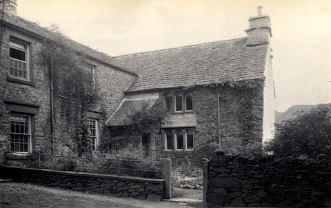 click to enlarge click to enlargeHB0065.jpg Vol.1 no.65 in an album, Examples of Early Domestic and Military Architecture in Westmorland, assembled 1910. ms at bottom:- "65. Hartsop Hall. Barton. W." item:- Armitt Library : 1958.3165.65 Image © see bottom of page |
|
|
|
||
| evidence:- | database:- Listed Buildings 2010 placename:- Hartsop Hall |
|
| source data:- | courtesy of English Heritage "HARTSOP HALL / / / PATTERDALE / EDEN / CUMBRIA / I / 452391 / NY3984812026" |
|
|
|
||
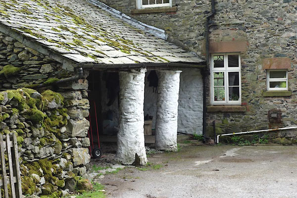 CAS19.jpg (taken 21.5.2014) 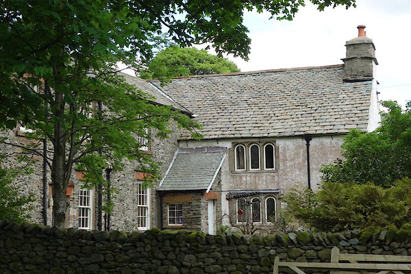 CAS20.jpg (taken 21.5.2014) 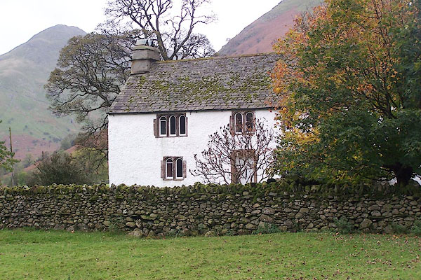 BMY55.jpg (taken 5.11.2006) |
||
|
|
||
| hearsay:- |
A G Bradley, 1910:- |
|
| "... possessed of the inconvenient disability of a public right-of-way through the
centre, now presumably lapsed." |
||
| "But till a few years ago a venerable champion of popular rights, or perhaps merely
a humorist with plenty of spare time, used to make an annual pilgrimage here, and
walk in at the front door and out at the back without any ceremony." |
||
|
|
||
| notes:- |
15th century hall |
|
| Perriam, D R &Robinson, J: 1998: Medieval Fortified Buildings of Cumbria: CWAAS::
ISBN 1 873124 23 6;plan and illustration |
||
|
|
||
Lakes Guides menu.