 Old Cumbria Gazetteer
 |
 |
|
||||||||||||||||||||||||
| Hawes Water | ||||||||||||||||||||||||||
| Haweswater Reservoir | ||||||||||||||||||||||||||
| civil parish:- | Bampton (formerly Westmorland) | |||||||||||||||||||||||||
| civil parish:- | Shap Rural (formerly Westmorland) | |||||||||||||||||||||||||
| county:- | Cumbria | |||||||||||||||||||||||||
| locality type:- | lake | |||||||||||||||||||||||||
| locality type:- | reservoir | |||||||||||||||||||||||||
| coordinates:- | NY47711364 (etc) | |||||||||||||||||||||||||
| 1Km square:- | NY4713 | |||||||||||||||||||||||||
| 10Km square:- | NY41 | |||||||||||||||||||||||||
|
|
||||||||||||||||||||||||||
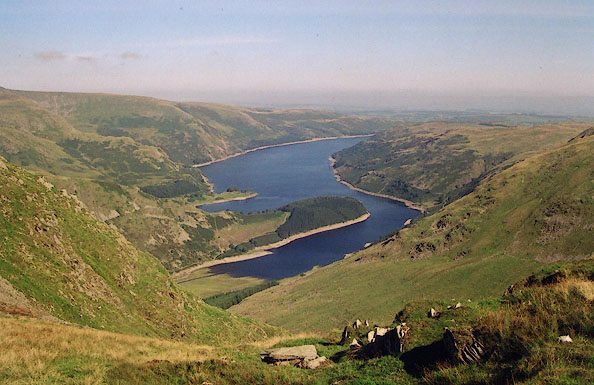 BJE08.jpg From Little Harter Fell. (taken 7.9.2004) 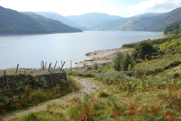 BZK30.jpg At Measand Becks. (taken 29.9.2013) |
||||||||||||||||||||||||||
|
|
||||||||||||||||||||||||||
| evidence:- | old map:- OS County Series (Wmd 13 15) placename:- Hawes Water |
|||||||||||||||||||||||||
| source data:- | Maps, County Series maps of Great Britain, scales 6 and 25
inches to 1 mile, published by the Ordnance Survey, Southampton,
Hampshire, from about 1863 to 1948. |
|||||||||||||||||||||||||
|
|
||||||||||||||||||||||||||
| evidence:- | old map:- OS County Series (Wmd 20 2) placename:- High Water placename:- Water, High |
|||||||||||||||||||||||||
| source data:- | Maps, County Series maps of Great Britain, scales 6 and 25
inches to 1 mile, published by the Ordnance Survey, Southampton,
Hampshire, from about 1863 to 1948. "High Water" about level with Ash Crag |
|||||||||||||||||||||||||
|
|
||||||||||||||||||||||||||
| evidence:- | old map:- Morden 1695 (Wmd) |
|||||||||||||||||||||||||
| source data:- | Map, hand coloured engraving, Westmorland, scale about 2.5 miles to 1 inch, by Robert
Morden, published by Abel Swale, the Unicorn, St Paul's Churchyard, Awnsham, and John
Churchill, the Black Swan, Paternoster Row, London, 1695.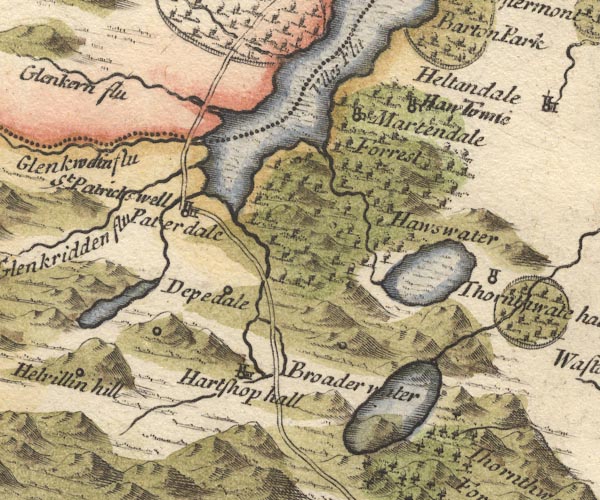 MD10NY41.jpg Outline with shore shading, tinted blue, with a hillock engraved within it. item:- JandMN : 24 Image © see bottom of page |
|||||||||||||||||||||||||
|
|
||||||||||||||||||||||||||
| evidence:- | perhaps old map:- Badeslade 1742 placename:- |
|||||||||||||||||||||||||
| source data:- | Map, uncoloured engraving, A Map of Westmorland North from
London, scale about 10 miles to 1 inch, with descriptive text,
by Thomas Badeslade, London, engraved and published by William
Henry Toms, Union Court, Holborn, London, 1742. click to enlarge click to enlargeBD12.jpg "" outline with form lines item:- Dove Cottage : 2007.38.62 Image © see bottom of page |
|||||||||||||||||||||||||
|
|
||||||||||||||||||||||||||
| evidence:- | descriptive text:- Simpson 1746 placename:- Broad Water Lake |
|||||||||||||||||||||||||
| source data:- | Atlas, three volumes of maps and descriptive text published as
'The Agreeable Historian, or the Compleat English Traveller
...', by Samuel Simpson, 1746. goto source goto sourcePage 1020:- "..." "... The Loder, or Lowther River is a very clear Stream without Mud, which rises in the Broad water Lake near Thornthwaite Forest; ..." |
|||||||||||||||||||||||||
|
|
||||||||||||||||||||||||||
| evidence:- | old map:- Simpson 1746 map (Wmd) |
|||||||||||||||||||||||||
| source data:- | Map, uncoloured engraving, Westmorland, scale about 8 miles to 1
inch, printed by R Walker, Fleet Lane, London, 1746.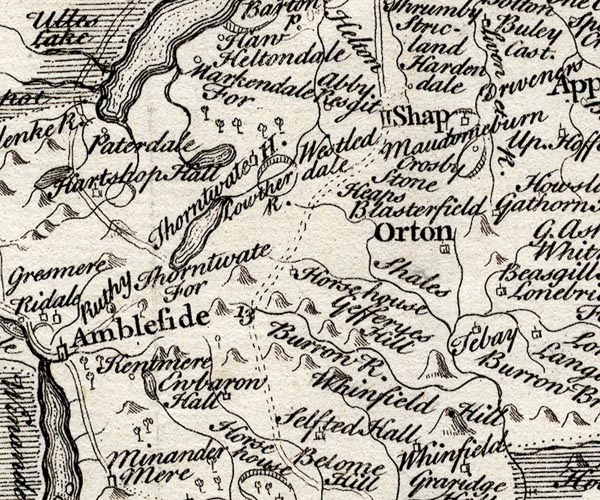 SMP2NYK.jpg Outline with form lines. item:- Dove Cottage : 2007.38.59 Image © see bottom of page |
|||||||||||||||||||||||||
|
|
||||||||||||||||||||||||||
| evidence:- | old map:- Bowen and Kitchin 1760 placename:- Broad Water |
|||||||||||||||||||||||||
| source data:- | Map, hand coloured engraving, A New Map of the Counties of
Cumberland and Westmoreland Divided into their Respective Wards,
scale about 4 miles to 1 inch, by Emanuel Bowen and Thomas
Kitchin et al, published by T Bowles, Robert Sayer, and John
Bowles, London, 1760.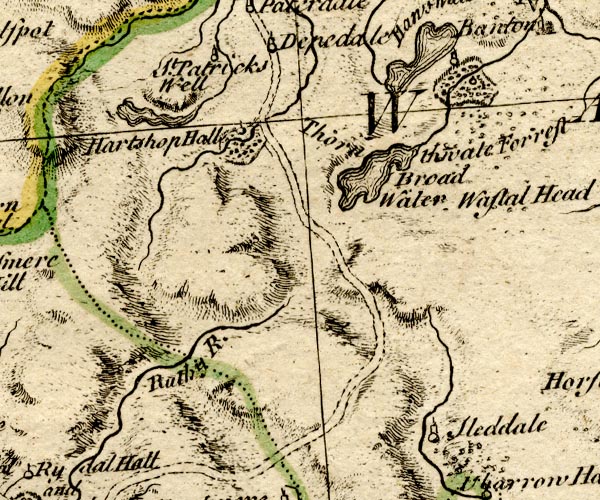 BO18NY30.jpg "Broad Water" outline with form lines item:- Armitt Library : 2008.14.10 Image © see bottom of page |
|||||||||||||||||||||||||
|
|
||||||||||||||||||||||||||
| evidence:- | old map:- Jefferys 1770 (Wmd) placename:- Hallswater |
|||||||||||||||||||||||||
| source data:- | Map, 4 sheets, The County of Westmoreland, scale 1 inch to 1
mile, surveyed 1768, and engraved and published by Thomas
Jefferys, London, 1770. J5NY41NE.jpg  J5NY41SE.jpg "HALLSWATER" outline with form lines; lake or tarn item:- National Library of Scotland : EME.s.47 Images © National Library of Scotland |
|||||||||||||||||||||||||
|
|
||||||||||||||||||||||||||
| evidence:- | descriptive text:- West 1778 (11th edn 1821) |
|||||||||||||||||||||||||
| source data:- | Guide book, A Guide to the Lakes, by Thomas West, published by
William Pennington, Kendal, Cumbria once Westmorland, and in
London, 1778 to 1821. goto source Page 162:- "..." "After what we have seen, the only lake that remains to be visited in this tour is" "HAWES-WATER." "This is a pleasant morning ride from Penrith; or it may be taken in the way to Shap, or from Shap, and return to Kendal. There" goto sourcePage 163:- "is also a road from Pooley-bridge, over the mountain to Bampton vale, a beautiful secreted valley. ..." "..." "Mr. Young is the first that says any thing in favour of this sweet but unfrequented lake." goto sourcePage 164:- "'The approach to the lake is very picturesque; you pass between two high ridges of mountains, the banks finely spread with inclosures; upon the right, two small beautiful hills, one of them covered with wood; they are most pleasantly elegant. The lake is a small one, above three miles long, half a mile over in places, and a quarter in others; almost divided in the middle by a promontory of inclosures, joined only by a strait, so that it consists of two sheets of water. The upper end of it is fine, quite inclosed with bold, steep craggy rocks and mountains; and in the centre of the end, a few little inclosures at their feet, waving upward in a very beautiful manner. The south side of the lake is a noble ridge of mountains, very bold and prominent down to the water's edge. They bulge out in the centre of a fine, bold, pendant, broad head, that is venerably magnificent: and the view of the first sheet of the lake, losing itself in the second, among hills, rocks, woods, &c. is picturesque. The opposite shore consists of inclosures, rising one above another, and crowned with craggy rocks [1]." "The narrowest part, by report, is 50 fathoms deep, and a man may throw a stone across it. Thwaite-force or fall, is a fine cataract on the" "[1] Six month's Tour, vol. 3d. page 168." goto sourcePage 165:- "right, and opposite to it, the first sheet of water is lost among the rocks and wood, in a beautiful manner. Bleakhow-crag, a ruinous rock, and over it, Castle-crag, a staring shattered rock, have a formidable appearance; and above all is seen Kidstow-pike, on whose summit the clouds weep into a crater of rock that is never empty. On the eastern side, a front of prominent rock bulges out into a solemn naked mass, and a waving cataract descends the furrowed side of a soft green hill. The contrast is fine - At Bleakhow-crag there is a pleasing back view." "Above the chapel, all is hopeless waste and desolation. The little vale contracts into a glen, strewed with the precipitated ruins of mouldering mountains, and the destruction of perpetual water-falls." "..." goto sourcePage 190:- "A TABLE OF THE Height of Mountains and Lakes SEEN IN THIS TOUR, ... TAKEN FROM THE LEVEL OF THE SEA. ... by Mr. John Dalton." "Hawes-water ... 238 [yards]" |
|||||||||||||||||||||||||
|
|
||||||||||||||||||||||||||
| evidence:- | old map:- West 1784 map placename:- Hawes Water |
|||||||||||||||||||||||||
| source data:- | Map, hand coloured engraving, A Map of the Lakes in Cumberland,
Westmorland and Lancashire, scale about 3.5 miles to 1 inch,
engraved by Paas, 53 Holborn, London, about 1784.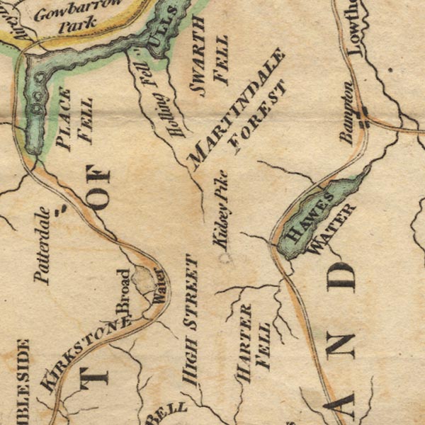 Ws02NY41.jpg "HAWES WATER" item:- Armitt Library : A1221.1 Image © see bottom of page |
|||||||||||||||||||||||||
|
|
||||||||||||||||||||||||||
| evidence:- | old map:- Cary 1789 (edn 1805) placename:- Halls Water |
|||||||||||||||||||||||||
| source data:- | Map, uncoloured engraving, Westmoreland, scale about 2.5 miles
to 1 inch, by John Cary, London, 1789; edition 1805. CY24NY41.jpg "Halls Water" outline with shore form lines; lake or tarn item:- JandMN : 129 Image © see bottom of page |
|||||||||||||||||||||||||
|
|
||||||||||||||||||||||||||
| evidence:- | old map:- Aikin 1790 (Wmd) placename:- |
|||||||||||||||||||||||||
| source data:- | Map, uncoloured engraving, Westmoreland ie Westmorland, scale
about 8.5 miles to 1 inch, by John Aikin, London, 1790. click to enlarge click to enlargeAIK2.jpg "" outline with form lines; lake item:- JandMN : 51 Image © see bottom of page |
|||||||||||||||||||||||||
|
|
||||||||||||||||||||||||||
| evidence:- | old painting:- Green 1790s-1820s item:- cattle |
|||||||||||||||||||||||||
| source data:- | Painting, watercolour, Haweswater, Shap Rural and Bampton, Westmorland, by William
Green, Ambleside, Westmorland, before 1823.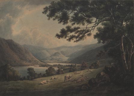 click to enlarge click to enlargePR1743.jpg item:- Dove Cottage : 1998.72.1 Image © see bottom of page |
|||||||||||||||||||||||||
|
|
||||||||||||||||||||||||||
| evidence:- | old map:- Bailey 1797 placename:- Horns Water |
|||||||||||||||||||||||||
| source data:- | Map, soil etc, uncoloured engraving, Westmoreland, scale about
12 miles to 1 inch, by J Bailey, engraved by Neele, Strand,
published by Messrs Robinson, Paternoster Row and G Nicol, Pall
Mall, London, 1797. click to enlarge click to enlargeBY05.jpg "Horns Water" outline with form lines; lake item:- Armitt Library : A680.3 Image © see bottom of page |
|||||||||||||||||||||||||
|
|
||||||||||||||||||||||||||
| evidence:- | old map:- Housman 1800 map 4 placename:- Haws Water |
|||||||||||||||||||||||||
| source data:- | Maps, hand coloured engraving, Lakes in Lancashire and Westmorland, 7 lakes on one
sheet, engraved by McIntyre, Edinburgh, published by F Jollie, Carlisle, Cumberland,
and C Law, Ave Maria Lane, London, 1800.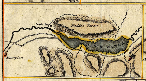 click to enlarge click to enlargeHM02Haw.jpg "HAWS WATER" item:- Dove Cottage : 2007.38.97 Image © see bottom of page |
|||||||||||||||||||||||||
|
|
||||||||||||||||||||||||||
| evidence:- | descriptive text:- Baker 1802 placename:- Hawswater |
|||||||||||||||||||||||||
| source data:- | Perspective road map with sections in Lancashire, Westmorland,
and Cumberland, by J Baker, London 1802. pp.25-26:- "..." "... By an easy ride through a country of much variety of landscape beauty, lying to the left of Shap, the traveller reaches the celebrated lake of Hawswater, which with Ullswater, (that may also be reached from a short road, dividing from the next stage), are ornamented with a variety of abrupt and terrific precipices, ..." |
|||||||||||||||||||||||||
|
|
||||||||||||||||||||||||||
| evidence:- | old map:- Baker 1802 placename:- Haweswater |
|||||||||||||||||||||||||
| source data:- | Perspective road maps with sections in Lancashire, Westmorland
and Cumberland, by J Baker, London 1802. Bk03Vg09.jpg "Haweswater / 268" item:- private collection : 3 Image © see bottom of page |
|||||||||||||||||||||||||
|
|
||||||||||||||||||||||||||
| evidence:- | old map:- Cooke 1802 placename:- Haws Water |
|||||||||||||||||||||||||
| source data:- | Map, The Lakes, Westmorland and Cumberland, scale about 8.5
miles to 1 inch, engravedby Neele and Son, published by
Sherwood, Jones and Co, Paternoster Road, London, 1824. click to enlarge click to enlargeGRA1Lk.jpg "Haws Water" outline with form lines; lake or tarn item:- Hampshire Museums : FA2000.62.5 Image © see bottom of page |
|||||||||||||||||||||||||
|
|
||||||||||||||||||||||||||
| evidence:- | old map:- Cooke 1802 placename:- Horns Water |
|||||||||||||||||||||||||
| source data:- | Map, Westmoreland ie Westmorland, scale about 12 miles to 1
inch, by George Cooke, 1802, published by Sherwood, Jones and
Co, Paternoster Road, London, 1824. click to enlarge click to enlargeGRA1Wd.jpg "Horns Water" outline with form lines; lake or tarn item:- Hampshire Museums : FA2000.62.4 Image © see bottom of page |
|||||||||||||||||||||||||
|
|
||||||||||||||||||||||||||
| evidence:- | old print:- Green 1804 (plate 37) placename:- Hawes Water |
|||||||||||||||||||||||||
| source data:- | Print, uncoloured aquatint, Foot of Hawes Water, Bampton, Westmorland, by William
Green, Ambleside, Westmorland, 1804 printed after 1807.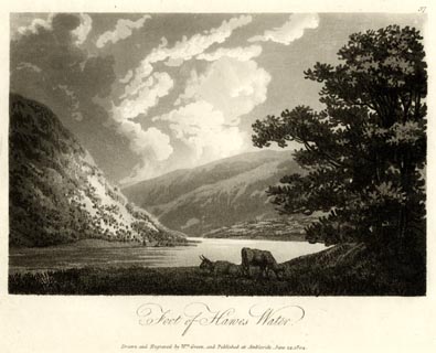 click to enlarge click to enlargeGN1637.jpg Plate 37 from a series. printed at bottom:- "Foot of Hawes Water. / Drawn and Engraved by Wm. Green, and Published at Ambleside, June 24, 1804." printed at top right:- "37" at :- "[ WHATMAN] / 1807" item:- Armitt Library : 2014.186 Image © see bottom of page |
|||||||||||||||||||||||||
|
|
||||||||||||||||||||||||||
| evidence:- | old map:- Laurie and Whittle 1806 placename:- Hawes Water |
|||||||||||||||||||||||||
| source data:- | Road map, Completion of the Roads to the Lakes, scale about 10
miles to 1 inch, by Nathaniel Coltman? 1806, published by Robert
H Laurie, 53 Fleet Street, London, 1834. click to enlarge click to enlargeLw18.jpg "Hawes Water" lake item:- private collection : 18.18 Image © see bottom of page |
|||||||||||||||||||||||||
|
|
||||||||||||||||||||||||||
| evidence:- | old text:- Capper 1808 placename:- Hawes Water |
|||||||||||||||||||||||||
| source data:- | Gazetteer, A Topographical Dictionary of the United Kingdom,
compiled by Benjamin Pitts Capper, published by Richard
Phillips, Bridge Street, Blackfriars, London, 1808; published
1808-29. goto source "..." "HAWES WATER, a beautiful lake, 5 miles distant of Kendal, in Westmoreland. The narrowest part of it is [5]0 fathoms deep, but so narrow that a stone may be thrown across it. ..." |
|||||||||||||||||||||||||
|
|
||||||||||||||||||||||||||
| evidence:- | old map:- Cooper 1808 placename:- Hawes Water |
|||||||||||||||||||||||||
| source data:- | Map, hand coloured engraving, Westmoreland ie Westmorland, scale
about 9 miles to 1 inch, by H Cooper, 1808, published by R
Phillips, Bridge Street, Blackfriars, London, 1808. click to enlarge click to enlargeCOP4.jpg "Hawes Water" outline, shaded; lake item:- Dove Cottage : 2007.38.53 Image © see bottom of page |
|||||||||||||||||||||||||
|
|
||||||||||||||||||||||||||
| evidence:- | old text:- Green 1810 placename:- Haws Water |
|||||||||||||||||||||||||
| source data:- | Set of prints, soft ground etchings, Sixty Studies from Nature,
by William Green, Ambleside, Westmorland, drawn 1808-10,
published 1810. goto source page 117:- "..." "HAWS WATER," "which is three miles long: it lies deeply intrenched among the mountains; its banks are sprinkled with trees as wildly as if shed from the heavens: footmen (not the party coloured gentlemen, for they would scorn such meanness) may make charming excursions, by passing from Kendal through Long Sleddale, over Harter Fell, by Chapel Hill, to Haws Water; and from thence by way of Powley Bridge, Ulls Water, and Patterdale to Ambleside ..." |
|||||||||||||||||||||||||
|
|
||||||||||||||||||||||||||
| evidence:- | old map:- Wallis 1810 (Wmd) placename:- Horns Water |
|||||||||||||||||||||||||
| source data:- | Road map, Westmoreland, scale about 19 miles to 1 inch, by James
Wallis, 77 Berwick Street, Soho, 1810, published by W Lewis,
Finch Lane, London, 1835? click to enlarge click to enlargeWAL5.jpg "Horns Water" outline, shaded; lake item:- JandMN : 63 Image © see bottom of page |
|||||||||||||||||||||||||
|
|
||||||||||||||||||||||||||
| evidence:- | descriptive text:- Wallis 1810 placename:- Broadwater |
|||||||||||||||||||||||||
| source data:- | Map, Westmoreland, scale about 19 miles to 1 inch, and
Cumberland, scale about 16 miles to 1 inch, by James Wallis, 77
Berwick Street, Soho, London, 1810; published 1810-36. "The Loder, rising at a lake called Broadwater, runs N.W., and falls into a small river called the Eimot, near the borders of this county." |
|||||||||||||||||||||||||
|
|
||||||||||||||||||||||||||
| evidence:- | old print:- Wilkinson 1810 (plate 47) placename:- Hawes Water |
|||||||||||||||||||||||||
| source data:- | Print, uncoloured soft ground etching, Hawes Water, Westmorland, by Joseph Wilkinson,
engraved by William Frederick Wells, published by R Ackermann, Repository of Arts,
101 Strand, London, 1810.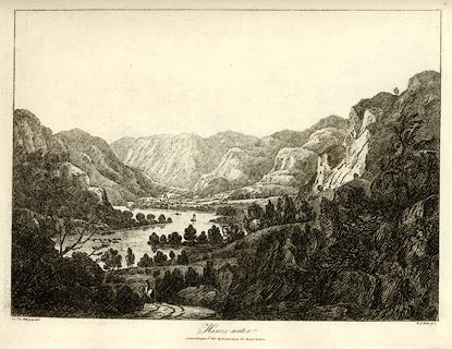 click to enlarge click to enlargeWKN147.jpg Plate 47 in Select Views in Cumberland, Westmoreland, and Lancashire. printed at bottom left, right, centre:- "Revd. Jos: Wilkenson delt. / W. F. Wells sc. / Hawes-water. / Published August 1. 1810. by R. Ackermann. 101. Strand. London." item:- Fell and Rock Climbing Club : MN4.47 Image © see bottom of page |
|||||||||||||||||||||||||
|
|
||||||||||||||||||||||||||
| evidence:- | old text:- Wordsworth 1810 placename:- Haweswater |
|||||||||||||||||||||||||
| source data:- | Guide book, A Description of the Scenery of the Lakes, later A
Guide through the District of The Lakes, by William Wordsworth,
1810-35. goto source page xxiii "..." "From Pooley Bridge, at the foot of the Lake, Haweswater may be conveniently visited. Haweswater is a lesser Ullswater, with this advantage, that it remains undefiled by the intrusion of bad taste." |
|||||||||||||||||||||||||
|
|
||||||||||||||||||||||||||
| evidence:- | old print:- Green 1814 (plate 60) placename:- Haws Water |
|||||||||||||||||||||||||
| source data:- | Print, tinted soft ground etching, Haws Water from Fordingdale Beck, Bampton, Westmorland,
by William Green, Ambleside, Westmorland, 1814.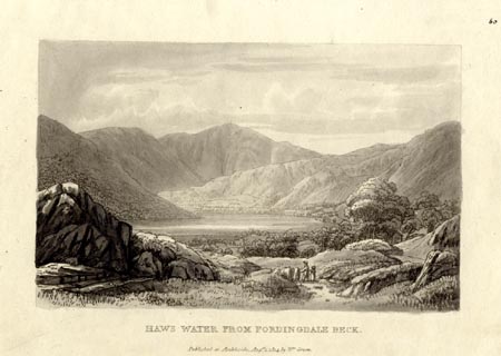 click to enlarge click to enlargeGN1060.jpg Plate 60 in Sixty Small Prints. printed at top right:- "60" printed at bottom:- "HAWS WATER FROM FORDINGDALE BECK. / Published at Ambleside Augst. 1, 1814, by Wm. Green." item:- Armitt Library : A6653.60 Image © see bottom of page |
|||||||||||||||||||||||||
|
|
||||||||||||||||||||||||||
| evidence:- | old print:- Green 1814 (plate 60) placename:- Haws Water |
|||||||||||||||||||||||||
| source data:- | Print, uncoloured soft ground etching, Haws Water from Fordingdale Beck, Bampton,
Westmorland, by William Green, Ambleside, Westmorland, 1814.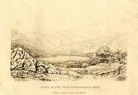 click to enlarge click to enlargeGN0960.jpg Plate 60 in Sixty Small Prints. printed at top right:- "60" printed at bottom:- "HAWS WATER FROM FORDINGDALE BECK. / Published at Ambleside Augst. 1, 1814, by Wm. Green." item:- Armitt Library : A6656.60 Image © see bottom of page |
|||||||||||||||||||||||||
|
|
||||||||||||||||||||||||||
| evidence:- | old print:- Green 1814 (plate 59) placename:- Haws Water item:- cattle |
|||||||||||||||||||||||||
| source data:- | Print, tinted soft ground etching, Haws Water, Shap Bampton/Rural, Westmorland, by
William Green, Ambleside, Westmorland, 1814.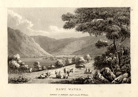 click to enlarge click to enlargeGN1059.jpg Plate 59 in Sixty Small Prints. printed at top right:- "59" printed at bottom:- "HAWS WATER. / Published at Ambleside Augst. 1, 1814, by Wm. Green." item:- Armitt Library : A6653.59 Image © see bottom of page |
|||||||||||||||||||||||||
|
|
||||||||||||||||||||||||||
| evidence:- | old print:- Green 1814 (plate 59) placename:- Haws Water item:- cattle |
|||||||||||||||||||||||||
| source data:- | Print, uncoloured soft ground etching, Haws Water, Shap Bampton/Rural, Westmorland,
by William Green, Ambleside, Westmorland, 1814.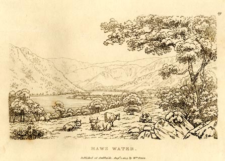 click to enlarge click to enlargeGN0959.jpg Plate 59 in Sixty Small Prints. printed at top right:- "59" printed at bottom:- "HAWS WATER. / Published at Ambleside Augst. 1, 1814, by Wm. Green." item:- Armitt Library : A6656.59 Image © see bottom of page |
|||||||||||||||||||||||||
|
|
||||||||||||||||||||||||||
| evidence:- | old text:- Green 1814 placename:- Haws Water |
|||||||||||||||||||||||||
| source data:- | Set of prints, soft ground etchings, Sixty Small Prints, with
text, A Description of a Series of Sixty Small Prints, by
William Green, Ambleside, Westmorland, 1814. goto source page 33:- "..." "Haws Water is three miles long, and generally about half a mile across; a richly wooded promontory, which from the lower grounds appears to cut the lake in two, shoots boldly towards the opposite shores, and here it is scarcely more" goto sourcepage 34:- "than two or three hundred yards in breadth. Mesand with its school stands near this promontory; on the side of which rushes, in wild impetuosity, Fordingdale Beck, a stream abounding in picturesque waterfalls." "Branstree, Harter Fell, Riggendale, High Street, Kidstay, and Whelter, are all grand mountains lying at the head of the lake: but this grandeur is diminished towards its foot; and the country below the outlet of the lake is composed of modest and easy eminences, which are pleasantly covered with wood all the way to Lowther and Askham." "Haws Water, either as a Salvator or a Claude, has great attractions; its magnificence may be appreciated by passing from the foot to the head of the lake, and its delicate beauties by looking down it." "Haws Water is fine from the carriage-road, but infinitely less so than from a horse-road upon the common, somewhat above the carriage-road; it is likewise good from many stands in the enclosures between the higher road and the water." "..." "The river feeding the lake at its head is bounded by flat lands; but the undulating surfaces between this flat and the summits of the circumjacent mountains being sprinkled in a luxuriant wildness with various sorts of trees, is on all hands a splendid treat for the lover and the artist." |
|||||||||||||||||||||||||
|
|
||||||||||||||||||||||||||
| evidence:- | old print:- Green 1815 placename:- Haws Water item:- sheep |
|||||||||||||||||||||||||
| source data:- | Print, coloured aquatint, Haws Water, Shap Rural, Westmorland, by William Green, Ambleside,
Westmorland, 1815.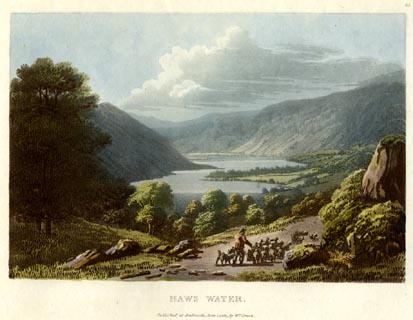 click to enlarge click to enlargeGN0523.jpg From the track from Gatescarth Pass to Mardale? Plate 25 in Lake Scenery. printed at upper right:- "25" printed at bottom:- "HAWS WATER. / Published at Ambleside, June 1, 1815, by Wm. Green." item:- Armitt Library : A6646.23 Image © see bottom of page |
|||||||||||||||||||||||||
|
|
||||||||||||||||||||||||||
| evidence:- | old print:- Green 1815 placename:- Haws Water |
|||||||||||||||||||||||||
| source data:- | Print, coloured aquatint, View down Haws Water from Mardale, Shap Rural, Westmorland,
by William Green, Ambleside, Westmorland, 1815.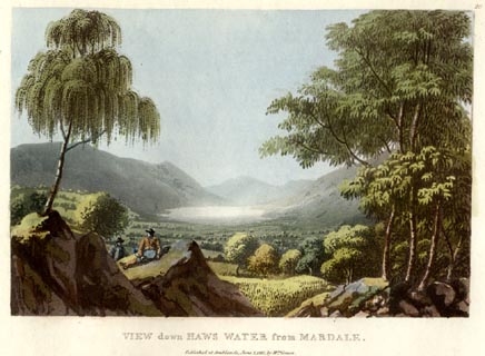 click to enlarge click to enlargeGN0524.jpg Plate 26 in Lake Scenery. printed at upper right:- "26" printed at bottom:- "VIEW down HAWS WATER from MARDALE. / Published at Ambleside, June 1, 1815, by Wm. Green." item:- Armitt Library : A6646.24 Image © see bottom of page |
|||||||||||||||||||||||||
|
|
||||||||||||||||||||||||||
| evidence:- | old print:- Green 1815 placename:- Haws Water |
|||||||||||||||||||||||||
| source data:- | Print, coloured aquatint, Head of Haws Water, Mardale, Shap Rural, Westmorland, by
William Green, Ambleside, Westmorland, 1815.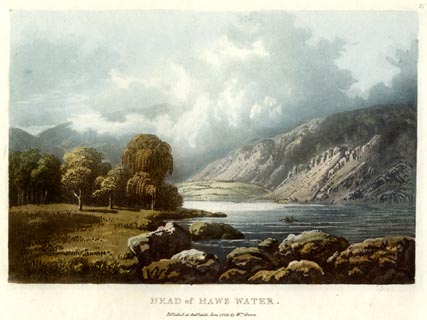 click to enlarge click to enlargeGN0525.jpg Plate 27 in Lake Scenery. printed at upper right:- "27" printed at bottom:- "HEAD of HAWS WATER. / Published at Ambleside, June 1, 1815, by Wm. Green." item:- Armitt Library : A6646.25 Image © see bottom of page |
|||||||||||||||||||||||||
|
|
||||||||||||||||||||||||||
| evidence:- | old map:- Otley 1818 placename:- Hawes Water |
|||||||||||||||||||||||||
| source data:- | Map, uncoloured engraving, The District of the Lakes,
Cumberland, Westmorland, and Lancashire, scale about 4 miles to
1 inch, by Jonathan Otley, 1818, engraved by J and G Menzies,
Edinburgh, Scotland, published by Jonathan Otley, Keswick,
Cumberland, et al, 1833.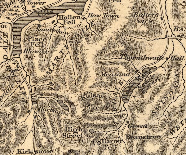 OT02NY41.jpg item:- JandMN : 48.1 Image © see bottom of page |
|||||||||||||||||||||||||
|
|
||||||||||||||||||||||||||
| evidence:- | old map:- Hall 1820 (Wmd) placename:- Hawes Water |
|||||||||||||||||||||||||
| source data:- | Map, hand coloured engraving, Westmoreland ie Westmorland, scale
about 14.5 miles to 1 inch, by Sidney Hall, London, 1820,
published by Samuel Leigh, 18 Strand, London, 1820-31. click to enlarge click to enlargeHA18.jpg "Hawes Wr." no symbol; lake item:- Armitt Library : 2008.14.58 Image © see bottom of page |
|||||||||||||||||||||||||
|
|
||||||||||||||||||||||||||
| evidence:- | old print:- Fielding and Walton 1821 (plate 42) placename:- Haws Water |
|||||||||||||||||||||||||
| source data:- | Print, coloured aquatint, Haws Water, Bampton, Westmorland, drawn by Theodore H A
Fielding, published by R Ackermann, 101 Strand, London, 1821.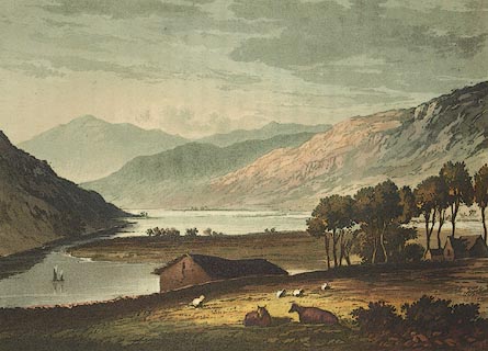 click to enlarge click to enlargeFW0142.jpg Tipped in opposite p.263 in A Picturesque Tour of the English Lakes. item:- Dove Cottage : 1993.R566.42 Image © see bottom of page |
|||||||||||||||||||||||||
|
|
||||||||||||||||||||||||||
| evidence:- | outline view:- Otley 1823 (8th edn 1849) placename:- Hawes Water |
|||||||||||||||||||||||||
| source data:- | Engraving, outline view of mountains, Hawes Water from Measand Beck, drawn by T Binns,
engraved by O Jewitt, opposite p.16 of A Descriptive Guide of the English Lakes, by
Jonathan Otley, 8th edition, 1849.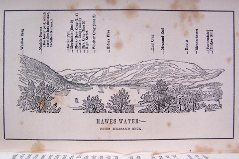 click to enlarge click to enlargeO80E09.jpg item:- Armitt Library : A1180.10 Image © see bottom of page |
|||||||||||||||||||||||||
|
|
||||||||||||||||||||||||||
| evidence:- | descriptive text:- Otley 1823 (5th edn 1834) item:- fishing |
|||||||||||||||||||||||||
| source data:- | Guide book, A Concise Description of the English Lakes, the
mountains in their vicinity, and the roads by which they may be
visited, with remarks on the mineralogy and geology of the
district, by Jonathan Otley, published by the author, Keswick,
Cumberland now Cumbria, by J Richardson, London, and by Arthur
Foster, Kirkby Lonsdale, Cumbria, 1823; published 1823-49,
latterly as the Descriptive Guide to the English Lakes. goto source Page 28:- "HAWES WATER" "Is nearly three miles in length and half a mile in breadth; it is almost divided into two parts by the projection of a plot of cultivated land from the N.W. side. Its head is encompassed by lofty mountains, but they exhibit less variety of outline than those of Derwent and Ullswater. Its eastern side is bounded by Naddle Forest, the lower part completely wooded, and surmounted by the lofty Wallow Crag; beyond which the hill side is scattered with aged thorns. The western side has more cultivation, and a few farm houses sheltered by trees. The houses - with the exception of Mr. Boustead's at Measand-beck, and Mr. Holmes' at Chapel hill - are mostly walled without mortar; and the deciduous trees associate well with the rest of the scenery. Opposite the head of the lake, Castle Crag is a prominent feature in the landscape." "This lake is well stocked with fish of various kinds; but they are chiefly preserved for the table of Lowther Castle." "Lying beyond the usual circuit of the lakes, and at a distance from the great roads and places of entertainment, Hawes Water is often omitted in the tour. But those who can contrive to visit it without hurry or fatigue, will find it a sweet retired spot." "..." goto sourcePage 114:- "EXCURSIONS TO HAWES WATER." "There are various mountain passes by which Hawes Water may be approached by pedestrians; and a way on horseback through Long Sleddale, has been described with a high degree of colouring in some former publications. In planning an excursion, several things are to be taken into consideration; as, what kind of conveyance the roads will admit of, how that conveyance is to be supplied, and at what places refreshment may be obtained. ..." "..." "But it will generally be found most convenient to visit Hawes Water from Penrith, by way of Eamont Bridge; turning to the right at Arthur's Round Table, to Askham 5 miles; thence by Helton, and Butterswick, to Bampton, nearly 5 more. ..." "Leaving Bampton Grange, with it church, on the left hand, two miles more bring us in sight of Hawes Water. Some will content themselves with travelling a couple of miles along the banks of the" goto sourcePage 116:- "lake, and thence return to the Grange for refreshment. ..." "Those who wish to penetrate the hidden recesses of the mountains may go the whole length of the lake, ... Here the mountains seem to forbid all further progress; but turning the end of the hill the party will soon arrive at Mardale Green; from whence they may either return the same way, or pass over the mountains to Long Sleddale or to Kentmere." "KENDAL TO HAWES WATER BY SHAP."
|
|||||||||||||||||||||||||
|
|
||||||||||||||||||||||||||
| evidence:- | descriptive text:- Ford 1839 (3rd edn 1843) placename:- Hawes Water item:- depth, Hawes Water |
|||||||||||||||||||||||||
| source data:- | Guide book, A Description of Scenery in the Lake District, by
Rev William Ford, published by Charles Thurnam, Carlisle, by W
Edwards, 12 Ave Maria Lane, Charles Tilt, Fleet Street, William
Smith, 113 Fleet Street, London, by Currie and Bowman,
Newcastle, by Bancks and Co, Manchester, by Oliver and Boyd,
Edinburgh, and by Sinclair, Dumfries, 1839. goto source Page 137:- "..." "HAWES WATER," "Belonging to the Earl of Lonsdale, is a less Ulles Water, undefiled by bad taste. It is three miles in length, and generally half-a-mile in breadth, abounding in perch, trout, eels, and chubs. The eastern side is screened by pretty wooded rocks, and its western girt by a few cultivated fields, thinly" goto sourcePage 138:- "studded with farm-houses, that are sheltered by groups of trees. A richly-wooded promontory, that stretches from the west side of the lake, appears to cut it into two: a little beyond is Fordingdale Beck, presenting some beautiful cascades, and the grand assemblage of mountains at the lake-head, in the noblest point of view. Branstree, Harter Fell, with its ridgy projection, Riggendale, High Street, Kidsty Pike, which has two points, and is low in the middle like Saddleback, and Whelter, stand around its head, and send down the trickling streams and silvery cascades to feed this interesting water. The views, indeed, in passing up, are a composition of magnificence and sublimity, as seen from the carriage-road in the most favourable manner; the scenes looking down the lake, form a striking contrast - all is rural beauty and sylvan sweetness." goto sourcePage 159:- "..." "Hawes Water.- The western side of this lake may be traversed by the tourist, as far as agreeable." goto sourcePage 177:- "A TABLE" "OF THE LENGTH, BREADTH, &c. OF THE LAKES," "COLLECTED FROM DIFFERENT AUTHORITIES."
|
|||||||||||||||||||||||||
|
|
||||||||||||||||||||||||||
| evidence:- | old map:- Ford 1839 map placename:- Hawes Water |
|||||||||||||||||||||||||
| source data:- | Map, uncoloured engraving, Map of the Lake District of
Cumberland, Westmoreland and Lancashire, scale about 3.5 miles
to 1 inch, published by Charles Thurnam, Carlisle, and by R
Groombridge, 5 Paternoster Row, London, 3rd edn 1843. FD02NY41.jpg "Hawes W." Outline with form lines. item:- JandMN : 100.1 Image © see bottom of page |
|||||||||||||||||||||||||
|
|
||||||||||||||||||||||||||
| evidence:- | old drawing:- Aspland 1840s-60s placename:- Hawes Water |
|||||||||||||||||||||||||
| source data:- | Drawing, pencil, Hawes Water, Westmorland, by Theophilus Lindsey Aspland, 1849.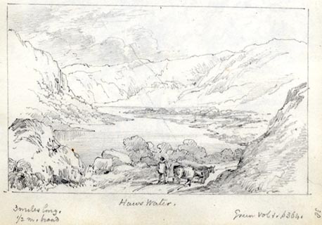 click to enlarge click to enlargeAS0146.jpg "Hawes Water. / 3 miles long. 1/2 m. broad / Green Vol 1. p364." item:- Armitt Library : 1958.487.46 Image © see bottom of page |
|||||||||||||||||||||||||
|
|
||||||||||||||||||||||||||
| evidence:- | old drawing:- Aspland 1840s-60s placename:- Haws Water |
|||||||||||||||||||||||||
| source data:- | Drawing, pencil, Hawes Water, Bampton, Westmorland, by Theophilus Lindsey Aspland,
1849.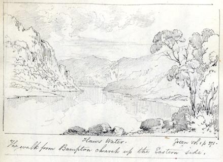 click to enlarge click to enlargeAS0181.jpg "Haws Water. / Green vol 1 p 371. / The walk from Bampton church up the Eastern side." item:- Armitt Library : 1958.487.81.1 Image © see bottom of page |
|||||||||||||||||||||||||
|
|
||||||||||||||||||||||||||
| evidence:- | old map:- Wyld 1847 placename:- Hawes Water |
|||||||||||||||||||||||||
| source data:- | Map, uncoloured engraving, Ulleswater and Hawes Water,
Cumberland and Westmorland, scale about 3.5 miles to 1 inch, by
James Wyld, published by John Johnstone, Paternoster Row,
London, et al, 1847. click to enlarge click to enlargeWLD3M4.jpg printed at bottom:- "ULLESWATER AND HAWES WATER." item:- Armitt Library : A1201.67 Image © see bottom of page |
|||||||||||||||||||||||||
|
|
||||||||||||||||||||||||||
| evidence:- | old map:- Garnett 1850s-60s H placename:- Hawes Water |
|||||||||||||||||||||||||
| source data:- | Map of the English Lakes, in Cumberland, Westmorland and
Lancashire, scale about 3.5 miles to 1 inch, published by John
Garnett, Windermere, Westmorland, 1850s-60s. GAR2NY41.jpg "HAWES WR." outline with shore form lines, lake or tarn item:- JandMN : 82.1 Image © see bottom of page |
|||||||||||||||||||||||||
|
|
||||||||||||||||||||||||||
| evidence:- | old print:- Pyne 1853 placename:- Hawes Water |
|||||||||||||||||||||||||
| source data:- | Print, tinted lithograph, Hawes Water and Wallergill Force, perhaps The Forces, Bampton,
Westmorland, by James Baker Pyne, engraved by W Gauci, published by Thomas Agnew and
Sons, Manchester, Lancashire, 1853.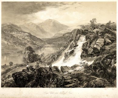 click to enlarge click to enlargePYN207.jpg "PAINTED BY J. B. PYNE. / W. GAUCI LITH. / MANCHESTER, PUBLISHED BY THOMAS AGNEW & SONS, 1853. / Hawes Water and Wallergill Force / M & N HANHART IMPT." item:- Armitt Library : A6678.8 Image © see bottom of page |
|||||||||||||||||||||||||
|
|
||||||||||||||||||||||||||
| evidence:- | old print:- Pyne 1853 placename:- Hawes Water |
|||||||||||||||||||||||||
| source data:- | Print, coloured lithograph, Hawes Water and Wallergill Force, perhaps The Forces,
Bampton, Westmorland, by James Baker Pyne, engraved by W Gauci, published by Thomas
Agnew and Sons, Manchester, Lancashire, 1853.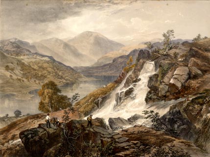 click to enlarge click to enlargePYN407.jpg item:- Armitt Library : A6677.8 Image © see bottom of page |
|||||||||||||||||||||||||
|
|
||||||||||||||||||||||||||
| evidence:- | old text:- Martineau 1855 |
|||||||||||||||||||||||||
| source data:- | Guide book, A Complete Guide to the English Lakes, by Harriet
Martineau, published by John Garnett, Windermere, Westmorland,
and by Whittaker and Co, London, 1855; published 1855-76. goto source Page 172:- "..." "Hawes Water lies about four miles from Askham. It is little more than three miles long, and about half a-mile broad. One side is richly wooded; the other nearly bare: and a pair of bold promontories threaten to cut it in two, in one part, where the passage is only two or three hundred yards wide. Round the head of the lake cluster the great mountains of Harter Fell, High Street, Kidsty Pike and others, leaving space among the skirts for the exquisite little valley of Mardale. Those who are able to obtain one of Lord Lonsdale's boats for the traverse of the lake may think themselves fortunate; for this is, of course, the most perfect way of seeing the surroundings of so small a sheet of water: and all other persons are deprived, by prohibition, of the means of doing so. There are some good houses on the shores and at the further end; but the occupants who live on the very brink are not allowed to keep any sort of boat. His lordship's boats are said to be procurable for the asking; but the preliminaries are a hindrance. The walk along the lake side is, how-" goto sourcePage 173:- "[how]ever, easy and agreeable enough. The road skirts the western bank. The crags which are sprinkled or heaped about the head of the lake are very fine. They jut out from the mountain side, or stand alone on the green slopes, or collect into miniature mountain clusters, which shelter tiny dells, whence the sheep send forth their bleat. ... Mardale ... at one end of the dale is the lake, and the other is closed in by the passes to Kentmere and Sleddale; and the great Pikes tower on either hand. The stream which gushes here and pauses there, as it passes among rough stones or through a green meadow, comes down from Small Water, reinforced by a brook from Blea Water on High Street, which joins the other a little above Mardale. ..." |
|||||||||||||||||||||||||
|
|
||||||||||||||||||||||||||
| evidence:- | old text:- Martineau 1855 placename:- Haweswater item:- depth, Hawes Water |
|||||||||||||||||||||||||
| source data:- | Guide book, A Complete Guide to the English Lakes, by Harriet
Martineau, published by John Garnett, Windermere, Westmorland,
and by Whittaker and Co, London, 1855; published 1855-76. goto source Page 180:- "A TABLE OF THE LENGTH, BREADTH, AND DEPTH OF THE LAKES." "No. : Names of Lakes. : Counties : Length in Miles. : Extreme breadth in Miles : Extreme depth in Feet : Height above the Sea" "2 : Haweswater : Westmorland : 3 : ½: - : 443" |
|||||||||||||||||||||||||
|
|
||||||||||||||||||||||||||
| evidence:- | probably fiction:- Trollope 1864 placename:- Hawes Water |
|||||||||||||||||||||||||
| source data:- | goto source chapter 31 Among the Fells "In less than five minutes they [Kate and Alice] were there; and then, but not till then, the beauty of the little lake, lying down below them in the quiet bosom of the hills, disclosed itself. A lake should, I think, be small, and should be seen from above, to be seen in all its glory. The distance should be such that the shadows of the mountains on its surface may just be traced, and that some faint idea of the ripple on the waters may be present to the eye. And the form of the lake should be irregular, curving round from its base among the lower hills, deeper and still deeper into some close nook up among the mountains from which its head waters spring. It is thus that a lake should be seen, and it was thus that Hawes Water was seen by them from the flat stone on the side of Swindale Fell. The basin of the lake has formed itself into the shape of the figure of 3, and the top section of the figure lies embosomed among the very wildest of the Westmoreland mountains. Altogether it is not above three miles long, and every point of it was to be seen from the spot on which the girls sat themselves down. The water beneath was as still as death, and as dark, - and looked almost as cold. But the slow clouds were passing over it, and the shades of darkness on its surface changed themselves with gradual changes. And though no movement was visible, there was ever and again in places a slight sheen upon the lake, which indicated the ripple made by the breeze." "'I'm so glad I've come here,' said Alice, seating herself. 'I cannot bear the idea of coming to Vavasor without seeing one of the lakes at least.'" "'We'll go over to Windermere one day,' said Kate. ..." |
|||||||||||||||||||||||||
|
|
||||||||||||||||||||||||||
| evidence:- | old print:- Payn 1867 placename:- Hawes Water item:- clapper bridge |
|||||||||||||||||||||||||
| source data:- | Print, uncoloured engraving, Hawes Water, from Measand, Bampton, Westmorland, by T
L Aspland, engraved by J Cooper, published by J Garnett, Windermere, Westmorland,
1867.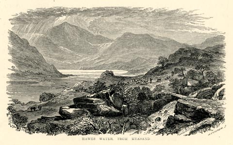 click to enlarge click to enlargePN0347.jpg On p.89 of The Lakes in Sunshine, text by James Payn. printed at lower right:- "J. COOPER Sc" printed at bottom:- "HAWES WATER, FROM MEASAND" item:- Fell and Rock Climbing Club : 184.47 Image © see bottom of page |
|||||||||||||||||||||||||
|
|
||||||||||||||||||||||||||
| evidence:- | old map:- Mill and Heawood 1895 placename:- Haweswater |
|||||||||||||||||||||||||
| source data:- | Map, Ullswater and Haweswater, scale 2 inches to 1 mile, with
soundings by Hugh Robert Mill and Edward Heawood, by
Bartholomew, Edinburgh, Scotland, published by George Philip and
Son, 32 Fleet Street, London, etc, 1895. click to enlarge click to enlargeMIL8.jpg - with soundings and sections item:- Kendal Library : 7.7 Image © see bottom of page |
|||||||||||||||||||||||||
|
|
||||||||||||||||||||||||||
| evidence:- | old photograph:- Ullswater Steamers 1900s (edn 1903) placename:- Haweswater |
|||||||||||||||||||||||||
| source data:- | Photograph, bw halftone, Haweswater from Bracken Howe, Westmorland, published in a
guide book by the Ullswater Steam Navigation Co, Penrith, Cumberland, 1903. click to enlarge click to enlargeUN117.jpg printed, bottom "HAWESWATER FROM BRACKEN HOWE" item:- JandMN : 1023.17 Image © see bottom of page |
|||||||||||||||||||||||||
|
|
||||||||||||||||||||||||||
| evidence:- | old print:- Bradley 1901 placename:- Haweswater |
|||||||||||||||||||||||||
| source data:- | Print, uncoloured lithograph, Haweswater, Shap Rural, Westmorland, by Joseph Pennell,
published by Macmillan and Co, London, 1901.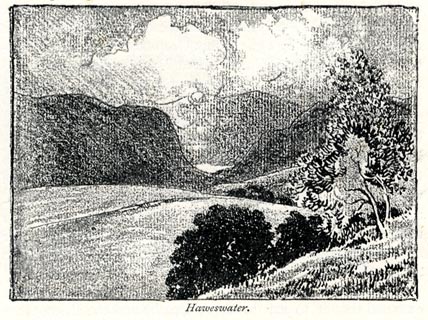 click to enlarge click to enlargeBRL181.jpg On page 306 of Highways and Byways in the Lake District, by A G Bradley. printed at bottom:- "Haweswater." item:- JandMN : 464.81 Image © see bottom of page |
|||||||||||||||||||||||||
|
|
||||||||||||||||||||||||||
| evidence:- | old print:- Heaton Cooper 1905 (edn 1908) placename:- Haweswater item:- boat house |
|||||||||||||||||||||||||
| source data:- | Print, colour halftone, Haweswater, Bampton/Shap Rural, Westmorland, from a watercolour
painting by Alfred Heaton Cooper, published by Adam and Charles Black, London, 2nd
edn 1908.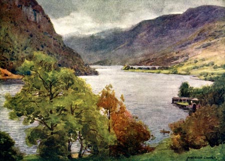 click to enlarge click to enlargeHC0159.jpg Opposite p.178 of The English Lakes, painted by Alfred Heaton Cooper, described by William T Palmer. printed at tissue opposite the print:- "HAWESWATER" printed at signed lower right:- "A HEATON COOPER" item:- JandMN : 468.59 Image © see bottom of page |
|||||||||||||||||||||||||
|
|
||||||||||||||||||||||||||
| evidence:- | old print:- Thompson 1860s-70s placename:- Haweswater item:- fish, Hawes Water; fishing; boat; rowing boat; fishing net |
|||||||||||||||||||||||||
| source data:- | Print, uncoloured engraving, Drawing the Net at Haweswater, drawn by Jacob Thompson,
1767, engraved by J C Armytage, published by Virtue and Co, London.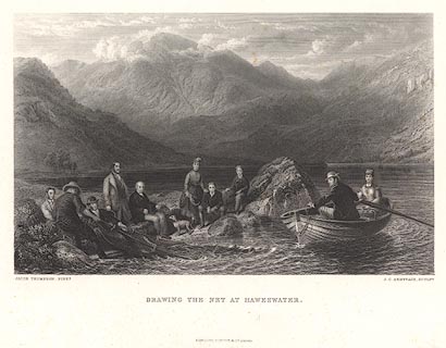 click to enlarge click to enlargeBNV35.jpg printed at bottom, left, right, and centre:- "JACOB THOMPSON, PINXT. / J. C. ARMYTAGE, SCULPT. / DRAWING THE NET AT HAWESWATER. / LONDON, VIRTUE &C. LIMITED" item:- JandMN : 124 Image © see bottom of page |
|||||||||||||||||||||||||
|
|
||||||||||||||||||||||||||
| evidence:- | old print:- placename:- Hawes Water |
|||||||||||||||||||||||||
| source data:- | Print, engraving with lithograph colour? Hawes Water, Westmorland, 1860s-70s?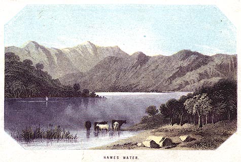 click to enlarge click to enlargePR0384.jpg printed at bottom:- "HAWES WATER." item:- Dove Cottage : 2008.107.384 Image © see bottom of page |
|||||||||||||||||||||||||
|
|
||||||||||||||||||||||||||
| evidence:- | old print:- Pyne 1853 placename:- Hawes Water |
|||||||||||||||||||||||||
| source data:- | Drawn by James Barker Pyne, 1848-1853, lithographed by T Picken, 1859.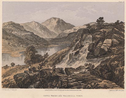 click to enlarge click to enlargePY10.jpg "Hawes Water and Wallergill Force" item:- JandMN : 97.11 Image © see bottom of page |
|||||||||||||||||||||||||
|
|
||||||||||||||||||||||||||
| evidence:- | old print:- Rose 1832-35 placename:- Hawes Water |
|||||||||||||||||||||||||
| source data:- | Print, engraving, Hawes Water, from Thwaite Force, Westmorland, by Thomas Allom, engraved
by W le Petit, 1833.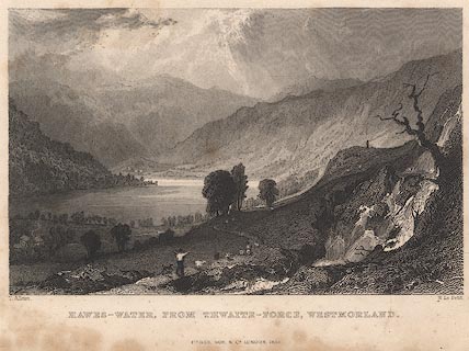 click to enlarge click to enlargeR170.jpg item:- JandMN : 41 Image © see bottom of page |
|||||||||||||||||||||||||
|
|
||||||||||||||||||||||||||
| evidence:- | old print:- Green 1819 placename:- Haws Water |
|||||||||||||||||||||||||
| source data:- | Print, aquatint, Haws Water, Westmorland, by William Green, 1819, published by R Lough
and Co, Chronicle Office, Finkle Street, Kendal, and others, 1820. click to enlarge click to enlargeGN0112.jpg Tipped in opposite vol.1 p.371 of The Tourist's New Guide, by William Green. printed at bottom right, centre:- "Vol.I, page 371, line 3. / HAWS WATER. / Published at Ambleside, Augt. 1. 1819, by Wm. Green." item:- Armitt Library : A1141.13 Image © see bottom of page |
|||||||||||||||||||||||||
|
|
||||||||||||||||||||||||||
| evidence:- | old print:- Green 1819 placename:- Haws Water |
|||||||||||||||||||||||||
| source data:- | Print, aquatint, Haws Water, Westmorland, by William Green, 1819, published by R Lough
and Co, Chronicle Office, Finkle Street, Kendal, and others, 1820. click to enlarge click to enlargeGN0111.jpg Tipped in opposite vol.1 p.364 of The Tourist's New Guide, by William Green. printed at bottom right, centre:- "Vol.I, page 364, line 27. / HAWS WATER. / Published at Ambleside, Augt. 1. 1819, by Wm. Green." item:- Armitt Library : A1141.12 Image © see bottom of page |
|||||||||||||||||||||||||
|
|
||||||||||||||||||||||||||
| evidence:- | old print:- Green 1815 (plate 26) placename:- Haws Water |
|||||||||||||||||||||||||
| source data:- | Print, colour aquatint, View Down Haws Water from Mardale, Shap Rural, Westmorland,
by William Green, Ambleside, Westmorland, 1815.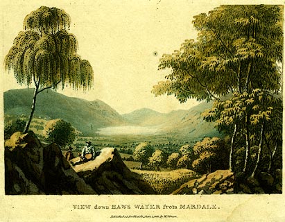 click to enlarge click to enlargePR0120.jpg Plate 26 in a set of prints, Lake Scenery. printed at bottom:- "VIEW DOWN HAWS WATER from MARDALE. / Published at Ambleside, June 1. 1815, by Wm. Green." item:- Dove Cottage : 2008.107.120 Image © see bottom of page |
|||||||||||||||||||||||||
|
|
||||||||||||||||||||||||||
| evidence:- | old print:- Green 1815 (plate 26) placename:- Haws Water |
|||||||||||||||||||||||||
| source data:- | Print, colour aquatint, View Down Haws Water from Mardale, Shap Rural, Westmorland,
by William Green, Ambleside, Westmorland, 1815.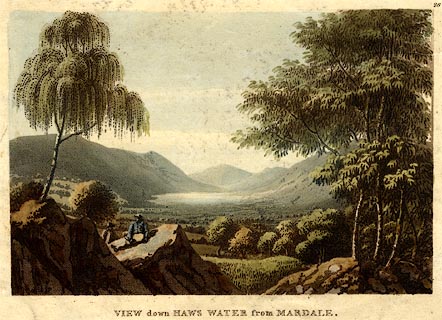 click to enlarge click to enlargePR0397.jpg Plate 26 in a set of prints, Lake Scenery. printed at top right:- "26" printed at bottom:- "VIEW DOWN HAWS WATER from MARDALE." item:- JandMN : 170 Image © see bottom of page |
|||||||||||||||||||||||||
|
|
||||||||||||||||||||||||||
| evidence:- | old print:- Green 1790s-1820s placename:- Hawes Water |
|||||||||||||||||||||||||
| source data:- | Print, uncoloured aquatint, Foot of Hawes Water, Bampton, Westmorland, drawn, engraved
and published by William Green, Ambleside, 1804.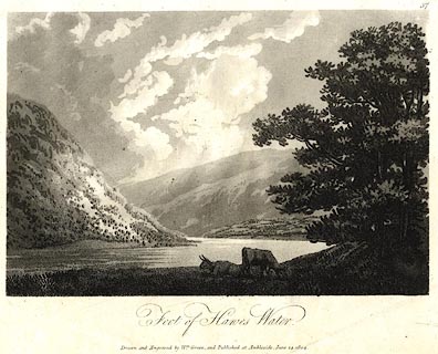 click to enlarge click to enlargePR0520.jpg Plate 37 in some series. printed at bottom:- "Foot of Hawes Water. / Drawn &Engraved by Wm. Green, and Published at Ambleside, June 24, 1804." item:- Dove Cottage : 2008.107.469 Image © see bottom of page |
|||||||||||||||||||||||||
|
|
||||||||||||||||||||||||||
| evidence:- | old print:- Lowther 1780s-90s placename:- Haws Water |
|||||||||||||||||||||||||
| source data:- | Print, uncoloured engraving, Haws Water near Shap, Westmoreland, drawn by E Dayes,
engraved by Medland, published late 18th century.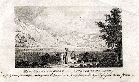 click to enlarge click to enlargePR0398.jpg printed at bottom:- "HAWS-WATER near SHAP,- WESTMORELAND. / Engraved by Medland, from an Original Drawing by E. DAYES, Draughtsman to His Royal Highness the DUKE of YORK.-" item:- JandMN : 167 Image © see bottom of page |
|||||||||||||||||||||||||
|
|
||||||||||||||||||||||||||
| evidence:- | old print:- placename:- Haws Water |
|||||||||||||||||||||||||
| source data:- | Print, uncoloured engraving, Haws Water near Shap, Westmoreland, drawn by E Dayes,
engraved by Medland, published late 18th century?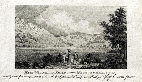 click to enlarge click to enlargePR0282.jpg printed at bottom:- "HAWS-WATER near SHAP,- WESTMORELAND. / Engraved by Medland, from an Original Drawing by E. DAYES, Draughtsman to His Royal Highness the DUKE of YORK.-" item:- Dove Cottage : 2008.107.282 Image © see bottom of page |
|||||||||||||||||||||||||
|
|
||||||||||||||||||||||||||
| evidence:- | old print:- Pearson 1900s placename:- Hawes Water |
|||||||||||||||||||||||||
| source data:- | Print, halftone photograph, Hawes Water, Low Water, Westmorland, published by C Arthur
Pearson, Henrietta Street, London, 1900s.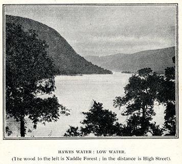 click to enlarge click to enlargePS1E77.jpg On p.226 of Pearson's Gossipy Guide to the English Lakes and Neighbouring Districts. printed at bottom:- "HAWES WATER: LOW WATER. / (The wood to the left is Naddle Forest; in the middle distance is High Street)." item:- Armitt Library : A1188.84 Image © see bottom of page |
|||||||||||||||||||||||||
|
|
||||||||||||||||||||||||||
| evidence:- | old print:- Payn 1860s-70s placename:- Hawes Water |
|||||||||||||||||||||||||
| source data:- | Print, colour printed, Hawes Water, Westmorland, published by John Garnett, Windermere,
Westmorland, and by Simpkin, Marshall and Co, London, 1860s-70s? click to enlarge click to enlargePN0111.jpg Tipped in opposite p.43 of England's Lakeland, a Tour Therein, by James Payn. printed at bottom:- "HAWES WATER." item:- Armitt Library : A1183.11 Image © see bottom of page |
|||||||||||||||||||||||||
|
|
||||||||||||||||||||||||||
| evidence:- | old drawing:- placename:- Hawes Water |
|||||||||||||||||||||||||
| source data:- | Drawing, Haweswater, Bampton, Westmorland, by John Harper, 1840.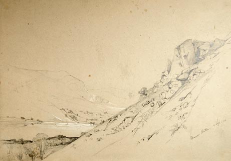 click to enlarge click to enlargePR1381.jpg Haweswater from the hills above the lake. Sloping hillside to right of composition with lake below and hills in distance. Executed in pencil with touches of white gouache on buff coloured paper. Preparatory sketch drawn on the spot by the artist. at bottom right:- "Hawes Water. 3 Sep./40" item:- Tullie House Museum : 2009.89.24 Image © Tullie House Museum |
|||||||||||||||||||||||||
|
|
||||||||||||||||||||||||||
| evidence:- | outline view:- Tattersall 1836 (version 1869) placename:- Hawes Water |
|||||||||||||||||||||||||
| source data:- | Print, hand coloured, Hawes Water, from Thwaite Force, Westmorland, drawn by George
Tattersall, 1836, engraved by W F Topham, published by T J Allman, 463 Oxford Street,
London, 1869.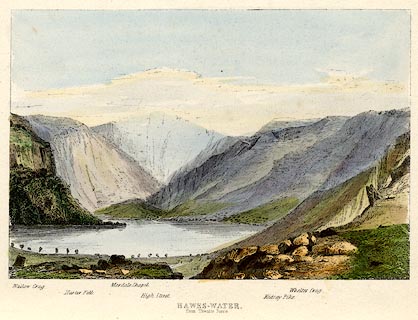 click to enlarge click to enlargeTAT217.jpg Included in The Lakes of England, by W F Topham. printed at bottom:- "HAWES-WATER, / from Thwaite Force." printed at bottom:- "Wallow Crag. / Harter Fell. / Mardale Chapel. / High Street. / Kidsay Pike. / Whelter Crag." item:- Armitt Library : A1067.17 Image © see bottom of page |
|||||||||||||||||||||||||
|
|
||||||||||||||||||||||||||
| evidence:- | old painting:- placename:- Haweswater item:- fishing |
|||||||||||||||||||||||||
| source data:- | Painting, engraving, A View of Haweswater, near Bampton, Westmoreland, by William
Bellers, Fleet Street, London, 1753.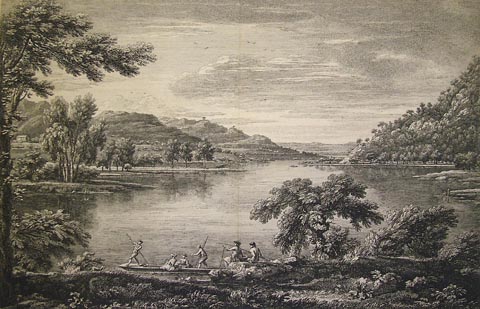 click to enlarge click to enlargePR1363.jpg view of Haweswater item:- Tullie House Museum : 2005.28 Image © Tullie House Museum |
|||||||||||||||||||||||||
|
|
||||||||||||||||||||||||||
| evidence:- | old print:- Bellers 1752-54 placename:- Haws Water |
|||||||||||||||||||||||||
| source data:- | Print, uncoloured engraving, A View of Haws Water, a lake near Banton in Westmoreland,
by William Bellers, engraved by Chatelin and Muller, published 1753.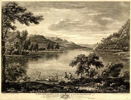 click to enlarge click to enlargePR1902.jpg "Painted after Nature by Willm. Bellers. / Etch'd & Engrav'd by Messrs. Chatelin & Muller. / A VIEW of HAWS-WATER, a LAKE near BANTON in WESTMORELAND. / To Sr. James Lowther Baronet, of Lowther. / This PLATE is inscrib'd by his most oblig'd humble Servant / Willm. Bellers. / Publish'd according to Act of Parliament September the 29th. 1753." plate number? "5" item:- Armitt Library : ALMA371 Image © see bottom of page |
|||||||||||||||||||||||||
|
|
||||||||||||||||||||||||||
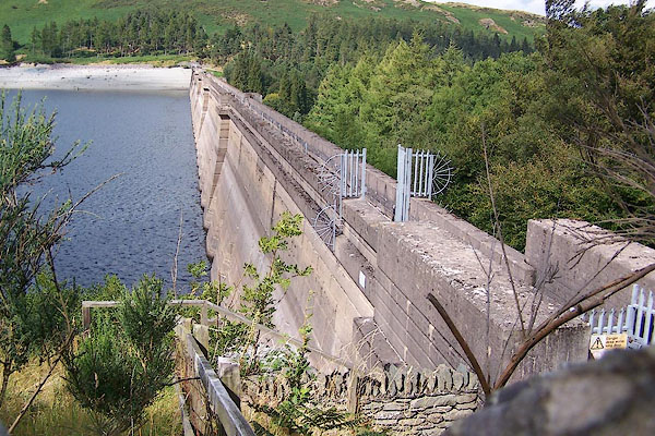 BJT64.jpg The dam, from the upper side, water 10m low. (taken 22.8.2005) 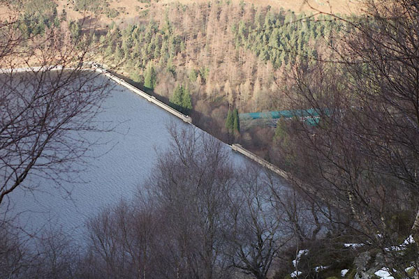 BZW92.jpg The dam. (taken 16.2.2014) 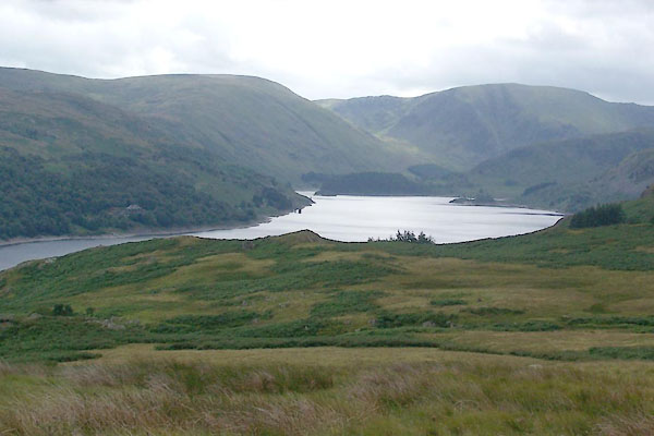 BTI03.jpg (taken 11.8.2010) 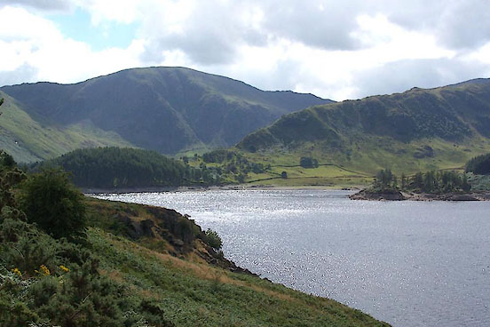 BJT67.jpg Harter Fell, Riggindale Crag, and Haweswater. (taken 22.8.2005) 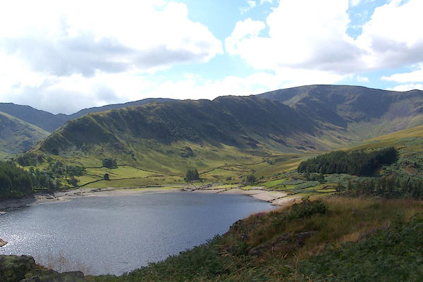 BJT68.jpg Riggindale Crag, High Street, and Haweswater. (taken 22.8.2005) 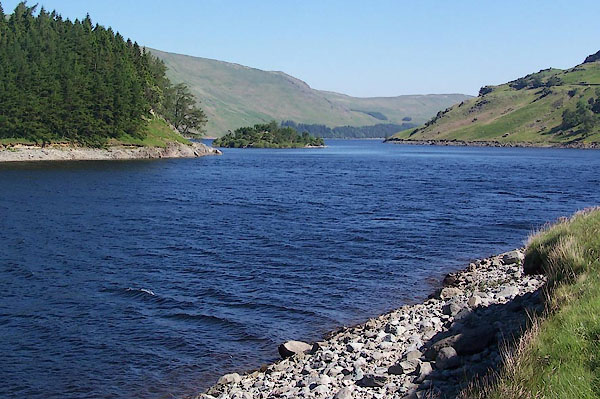 BMF83.jpg From the north end. (taken 10.6.2006) 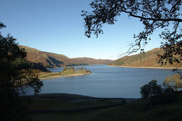 BTR94.jpg From the south end. (taken 20.10.2010) 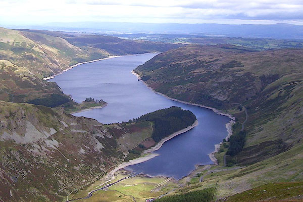 BOE73.jpg (taken 18.9.2007) 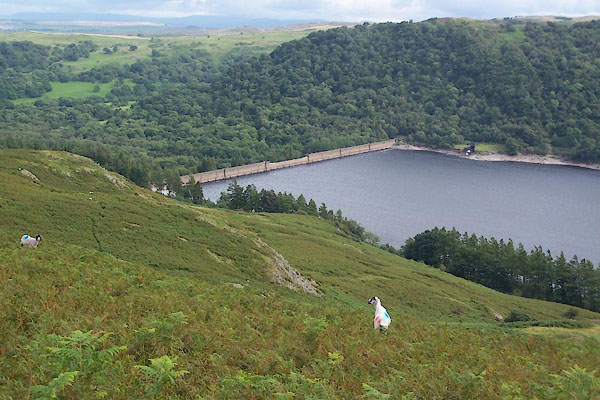 BTI08.jpg (taken 11.8.2010) 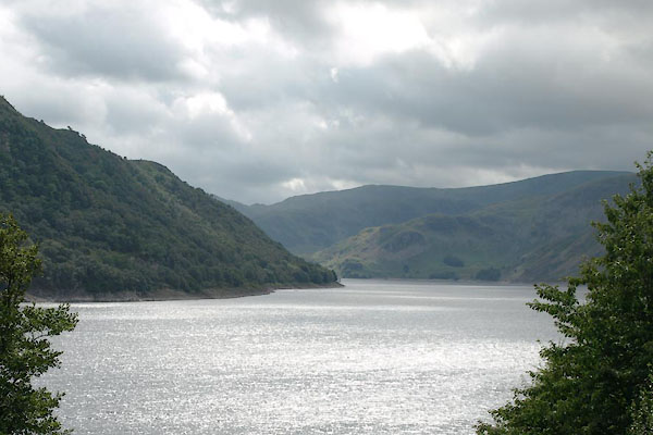 BTH83.jpg From NW shore near Burnbanks. (taken 11.8.2010) 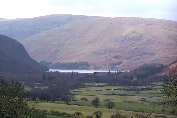 BJQ54.jpg (taken 22.7.2005) 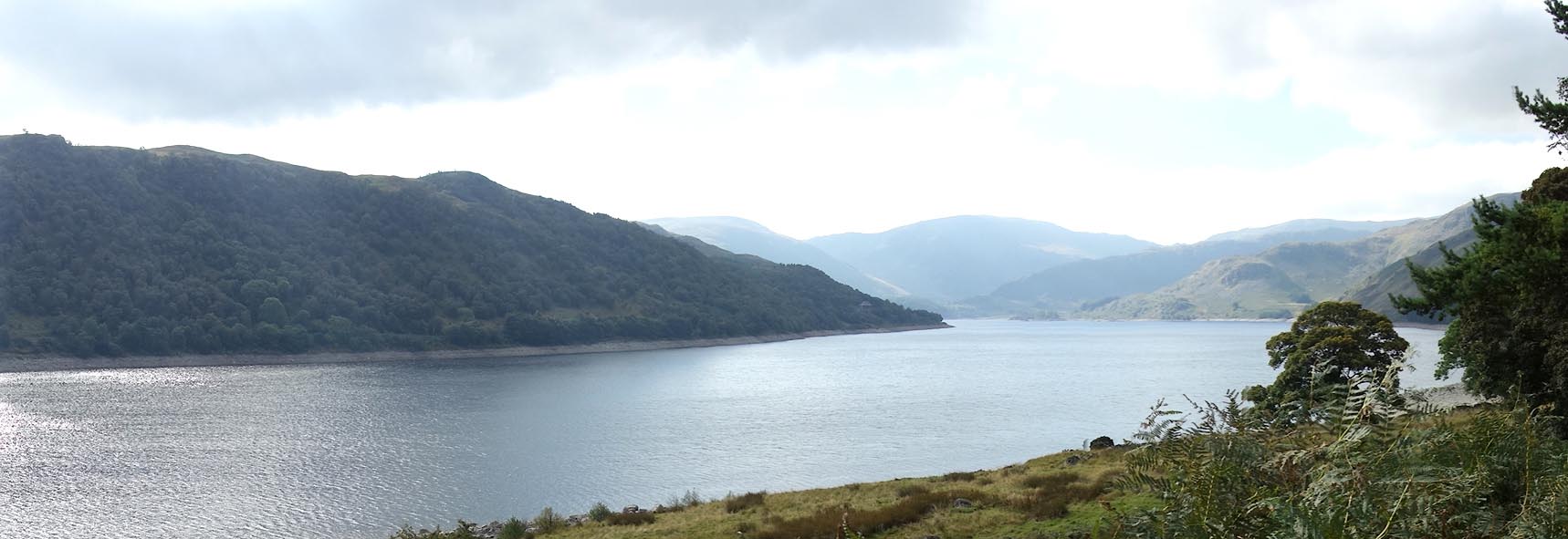 Click to enlarge BZK28.jpg From near Measand Becks. (taken 29.9.2013) |
||||||||||||||||||||||||||
|
|
||||||||||||||||||||||||||
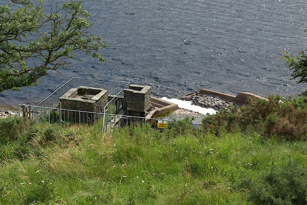 BTH82.jpg Water from Heltondale and (taken 11.8.2010) 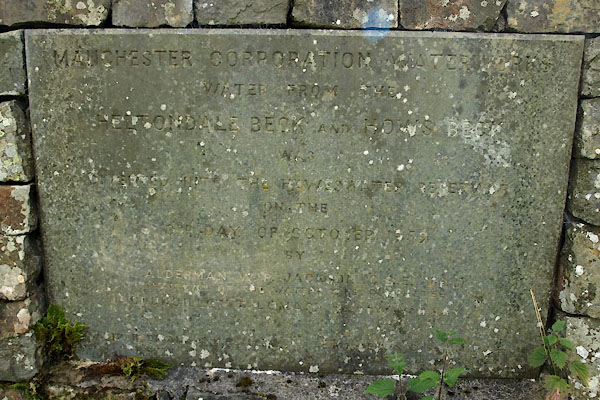 BTH81.jpg Plaque:- "MANCHESTER CORPORATION WATERWORKS / WATER FROM THE / HELTONDALE BECK AND HOWS BECK / WAS / DIVERTED INTO THE HAWESWATER RESERVOIR / ON THE / 3RD DAY OF OCTOBER 1959 / ..." (taken 11.8.2010) |
||||||||||||||||||||||||||
|
|
||||||||||||||||||||||||||
| notes:- |
An OS 6 inch map states:- |
|||||||||||||||||||||||||
| "Haweswater Reservoir / Top water level 241 metres above Newlyn datum 1973" |
||||||||||||||||||||||||||
|
|
||||||||||||||||||||||||||
| hearsay:- |
The Act of Parliament authorising Manchester Corporation to build the dam passed in
1919. Land purchase was completed by 1925, construction was completed in 1941. The
dam was first filled in December 1942. |
|||||||||||||||||||||||||
| The dam is a hollow concrete buttress type. A plumb bob hangs somewhere inside to
monitor movement of the dam; it was deflected a 1/20th of an inch by the time the
dam was full. |
||||||||||||||||||||||||||
|
|
||||||||||||||||||||||||||
Lakes Guides menu.