 Old Cumbria Gazetteer
 |
 |
|
| Hayes Castle, Distington | ||
| Hayes Castle | ||
| Street:- | Hayes Castle Road | |
| civil parish:- | Lowca (formerly Cumberland) | |
| county:- | Cumbria | |
| locality type:- | castle (ruins) | |
| coordinates:- | NY00122258 | |
| 1Km square:- | NY0022 | |
| 10Km square:- | NY02 | |
|
|
||
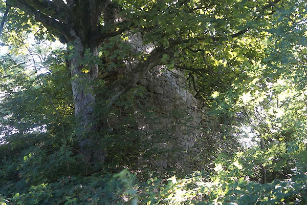 CFL59.jpg (taken 2.9.2016) |
||
|
|
||
| evidence:- | old map:- OS County Series (Cmd 61 7) placename:- Hayes Castle |
|
| source data:- | Maps, County Series maps of Great Britain, scales 6 and 25
inches to 1 mile, published by the Ordnance Survey, Southampton,
Hampshire, from about 1863 to 1948. "Hayes Castle (Remains of) / Moat (Remains of)" |
|
|
|
||
| evidence:- | old map:- Speed 1611 (Cmd) placename:- Hay Castle |
|
| source data:- | Map, hand coloured engraving, Cumberland and the Ancient Citie
Carlile Described, scale about 4 miles to 1 inch, by John Speed,
1610, published by J Sudbury and George Humble, Popes Head
Alley, London, 1611-12.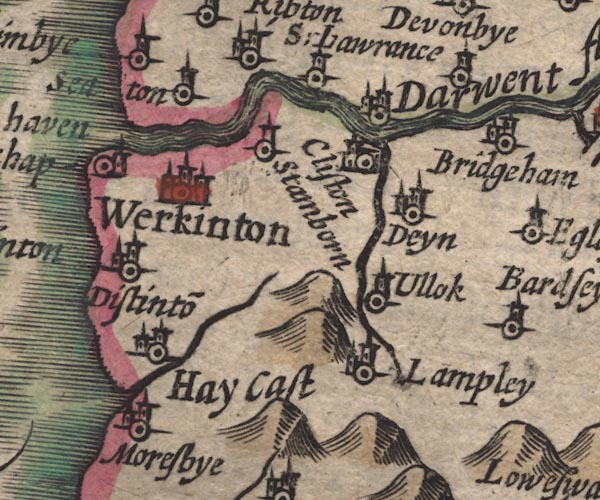 SP11NY02.jpg "Hay Cast" circle, building, tower item:- private collection : 16 Image © see bottom of page |
|
|
|
||
| evidence:- | perhaps old map:- Morden 1695 (Cmd) placename:- Haye Castle |
|
| source data:- | Map, uncoloured engraving, Cumberland, scale about 4 miles to 1
inch, by Robert Morden, 1695, published by Abel Swale, the
Unicorn, St Paul's Churchyard, Awnsham, and John Churchill, the
Black Swan, Paternoster Row, London, 1695-1715.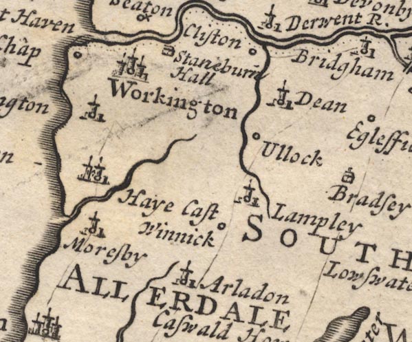 MD12NY02.jpg "Haye Cast" Circle, building with two towers, sharing a symbol with Distington. item:- JandMN : 90 Image © see bottom of page |
|
|
|
||
| evidence:- | old map:- Bowen and Kitchin 1760 placename:- Hay Castle |
|
| source data:- | Map, hand coloured engraving, A New Map of the Counties of
Cumberland and Westmoreland Divided into their Respective Wards,
scale about 4 miles to 1 inch, by Emanuel Bowen and Thomas
Kitchin et al, published by T Bowles, Robert Sayer, and John
Bowles, London, 1760. BO18NX92.jpg "Hay Castle" circle and flag item:- Armitt Library : 2008.14.10 Image © see bottom of page |
|
|
|
||
| evidence:- | old map:- Donald 1774 (Cmd) placename:- Hay Castle |
|
| source data:- | Map, hand coloured engraving, 3x2 sheets, The County of Cumberland, scale about 1
inch to 1 mile, by Thomas Donald, engraved and published by Joseph Hodskinson, 29
Arundel Street, Strand, London, 1774.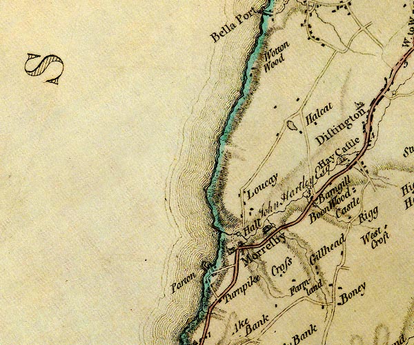 D4NX92SE.jpg "Hay Castle / John Hartley Esq" large building; a castle item:- Carlisle Library : Map 2 Image © Carlisle Library |
|
|
|
||
| evidence:- | old text:- Clarke 1787 placename:- Hay Castle |
|
| source data:- | Guide book, A Survey of the Lakes of Cumberland, Westmorland,
and Lancashire, written and published by James Clarke, Penrith,
Cumberland, and in London etc, 1787; published 1787-93. goto source goto sourcePage 105:- "..." "I do not find any ancient authors mention a castle here [Castlerigg], Speed, who speaks of twenty-five in Cumberland, hath found out every one I ever heard or knew of, except Kirkoswald; how that has escaped him I cannot tell. I shall here put down their names, and, as well as I can, their most ancient owners, and supposed founders." "..." goto sourcePage 106:- "..." "20. HAY CASTLE, - Some say, stood upon the rock in Borrowdale called Castle, behind Grainge, built by the Romans, (as named before,) others say (as Speed) a place near Whitehaven, which I cannot find." "..." |
|
|
|
||
| evidence:- | old text:- Camden 1789 placename:- Hay Castle |
|
| source data:- | Book, Britannia, or A Chorographical Description of the Flourishing Kingdoms of England,
Scotland, and Ireland, by William Camden, 1586, translated from the 1607 Latin edition
by Richard Gough, published London, 1789. goto source Page 170:- "..." "... Hay Castle, respectable for its antiquity, which the people told me once belonged to the noble families of Moresby and Distinton." |
|
|
|
||
| evidence:- | old text:- Camden 1789 (Gough Additions) placename:- Hayes Castle |
|
| source data:- | Book, Britannia, or A Chorographical Description of the Flourishing Kingdoms of England,
Scotland, and Ireland, by William Camden, 1586, translated from the 1607 Latin edition
by Richard Gough, published London, 1789. goto source Page 181:- "..." "Hayes castle is the capital messuage belonging to Distington manor. It belonged to the Moresbys, and is now the property of Mr. Hartley, merchant in Whitehaven." |
|
|
|
||
| evidence:- | old text:- Gents Mag placename:- Dykhurst |
|
| source data:- | Magazine, The Gentleman's Magazine or Monthly Intelligencer or
Historical Chronicle, published by Edward Cave under the
pseudonym Sylvanus Urban, and by other publishers, London,
monthly from 1731 to 1922. goto source Gentleman's Magazine 1856 part 2 pp.323-330 "..." "LICENCES TO CRENELLATE, FROM THE PATENT ROLLS IN THE TOWER OF LONDON." "[Edward II continued]" "..." "15. Robertus de Leyburn mansum Dykhurst ... Cumbr." "..." |
|
|
|
||
| evidence:- | text:- Curwen 1913 placename:- Aykhurst item:- licence to crenellate |
|
| source data:- | Book, The Castles and Fortified Towers of Cumberland,
Westmorland, and Lancashire North of the Sands, by John F
Curwen, published for the Cumberland and Westmorland Antiquarian
and Archaeological Society by Titus Wilson, Kendal, Westmorland,
1913. Licence to crenellate granted by Edward II; 13 March 1322:- "Rex omnibus ballivis et fidelibus suis ad quos etc. salutem. Sciatis quod in gratia nostra speciali concessimus pro nobis in heredibus nostris dilecto et fideli nostro Roberto de Leyburn' quod ipse mansum suum de Aykhurst in Comitatu Cumbriensi muro de petra et calce firmari et kernellare, et mansum illud sic firmatum et kernellatum tenere possit sibi et heredibus suis imperpetuum sine occasione vel impedimento nostri vel heredum nostrorum vicecomitum aut aliorum ballivorum seu ministrorum nostrorum quorumcumque. In cujus etc. Teste Rege apud Derby xiij die Marcii" |
|
|
|
||
| evidence:- | text:- Jackson 1990 placename:- Aykerist Castle placename:- Aykhurst Castle placename:- Dykhurst Castle placename:- Hay Castle |
|
| source data:- | ||
|
|
||
| evidence:- | database:- Listed Buildings 2010 placename:- Hayes Castle |
|
| source data:- | courtesy of English Heritage "HAYES CASTLE / / HAYES CASTLE ROAD / DISTINGTON / COPELAND / CUMBRIA / II / 76118 / NY0013122558" |
|
| source data:- | courtesy of English Heritage "Castle. Present name probably a corruption of Aykhurst for which a licence to crenellate was issued in 1322 to Robert de Leyburn; probably established before this date. Originally consisted of tower house on motte with curtain wall and moat, now ruinous. Moat survives on north and west sides, but only north wall of square-plan tower house remains on motte. Sandstone block facings with rubble core; c4 ft thick and c20 ft high. Other stones re-used in surrounding buildings. Scheduled Ancient Monument." |
|
|
|
||
| notes:- |
14th century tower, etc |
|
| Perriam, D R &Robinson, J: 1998: Medieval Fortified Buildings of Cumbria: CWAAS::
ISBN 1 873124 23 6; illustration |
||
|
|
||
Lakes Guides menu.