 Old Cumbria Gazetteer
 |
 |
|
| Hayeswater | ||
| runs into:- |  Hayeswater Gill Hayeswater Gill |
|
|
|
||
| civil parish:- | Patterdale (formerly Westmorland) | |
| county:- | Cumbria | |
| locality type:- | tarn | |
| coordinates:- | NY43111220 (etc) | |
| 1Km square:- | NY4312 | |
| 10Km square:- | NY41 | |
| altitude:- | 1395 feet | |
| altitude:- | 425m | |
|
|
||
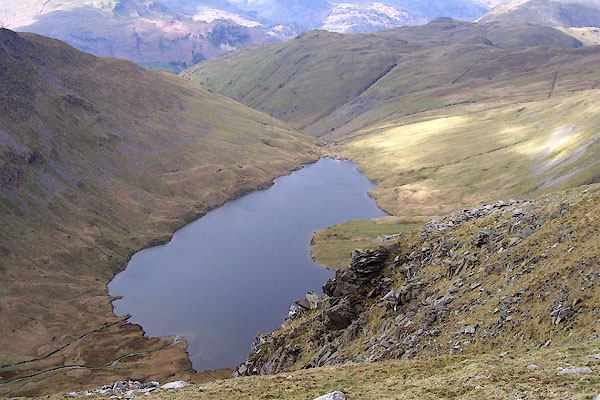 BNO89.jpg (taken 18.4.2007) 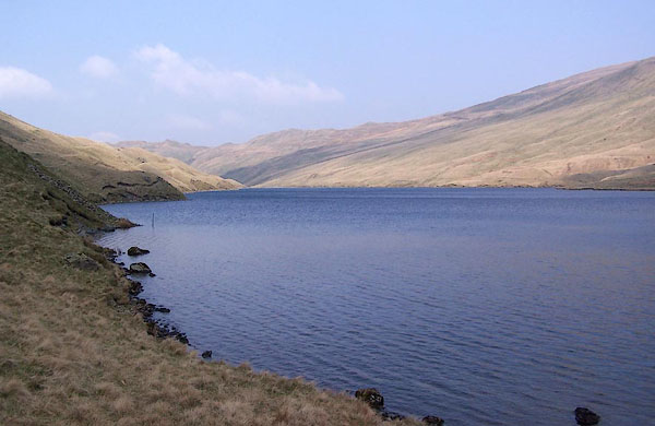 BQK85.jpg (taken 16.4.2009) |
||
|
|
||
| evidence:- | descriptive text:- |
|
| source data:- | Hayswater by Matthew Arnold:- "A region desolate and wild, Black, chafing water, and afloat, And lonely as a truant child In a waste wood, a single boat: No mast, no sails are set thereon; It moves, but never moveth on; And welters like a human thing Amid the wild waves weltering." "Behind, a buried vale doth sleep, Far down the torrent cleaves its way: In front the dumb rock rises steep, A fretted wall of blue and grey; Of shooting cliff and crumbled stone With many a wild weed overgrown; All esle, black water; and afloat. One rood from shore, that single boat." |
|
|
|
||
| evidence:- | old map:- Morden 1695 (Wmd) placename:- Hawswater |
|
| source data:- | Map, hand coloured engraving, Westmorland, scale about 2.5 miles to 1 inch, by Robert
Morden, published by Abel Swale, the Unicorn, St Paul's Churchyard, Awnsham, and John
Churchill, the Black Swan, Paternoster Row, London, 1695.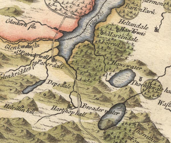 MD10NY41.jpg "Hawswater" Outline with shore shading, tinted blue. item:- JandMN : 24 Image © see bottom of page |
|
|
|
||
| evidence:- | perhaps old map:- Badeslade 1742 placename:- |
|
| source data:- | Map, uncoloured engraving, A Map of Westmorland North from
London, scale about 10 miles to 1 inch, with descriptive text,
by Thomas Badeslade, London, engraved and published by William
Henry Toms, Union Court, Holborn, London, 1742. click to enlarge click to enlargeBD12.jpg "" outline with form lines item:- Dove Cottage : 2007.38.62 Image © see bottom of page |
|
|
|
||
| evidence:- | probably old map:- Simpson 1746 map (Wmd) |
|
| source data:- | Map, uncoloured engraving, Westmorland, scale about 8 miles to 1
inch, printed by R Walker, Fleet Lane, London, 1746.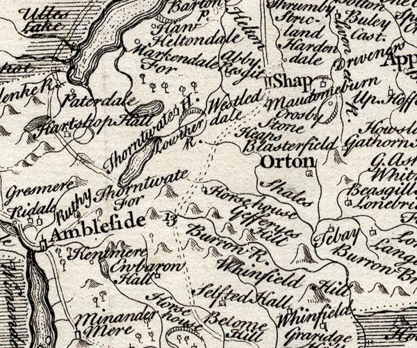 SMP2NYK.jpg Outline with form lines; drained by Bannerdale Beck?. item:- Dove Cottage : 2007.38.59 Image © see bottom of page |
|
|
|
||
| evidence:- | old map:- Bowen and Kitchin 1760 placename:- Haws Water |
|
| source data:- | Map, hand coloured engraving, A New Map of the Counties of
Cumberland and Westmoreland Divided into their Respective Wards,
scale about 4 miles to 1 inch, by Emanuel Bowen and Thomas
Kitchin et al, published by T Bowles, Robert Sayer, and John
Bowles, London, 1760.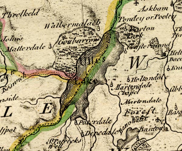 BO18NY31.jpg "Haws Water" outline with form lines item:- Armitt Library : 2008.14.10 Image © see bottom of page |
|
|
|
||
| evidence:- | old map:- Jefferys 1770 (Wmd) |
|
| source data:- | Map, 4 sheets, The County of Westmoreland, scale 1 inch to 1
mile, surveyed 1768, and engraved and published by Thomas
Jefferys, London, 1770.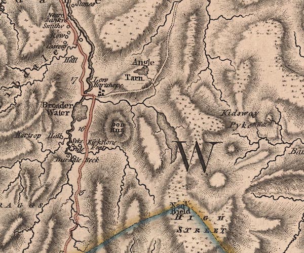 J5NY41SW.jpg outline with form lines; lake or tarn item:- National Library of Scotland : EME.s.47 Image © National Library of Scotland |
|
|
|
||
| evidence:- | old map:- Cary 1789 (edn 1805) |
|
| source data:- | Map, uncoloured engraving, Westmoreland, scale about 2.5 miles
to 1 inch, by John Cary, London, 1789; edition 1805. CY24NY41.jpg outline with shore form lines; lake or tarn item:- JandMN : 129 Image © see bottom of page |
|
|
|
||
| evidence:- | old map:- Laurie and Whittle 1806 placename:- Hays Water |
|
| source data:- | Road map, Completion of the Roads to the Lakes, scale about 10
miles to 1 inch, by Nathaniel Coltman? 1806, published by Robert
H Laurie, 53 Fleet Street, London, 1834. click to enlarge click to enlargeLw18.jpg "Hays Water" lake item:- private collection : 18.18 Image © see bottom of page |
|
|
|
||
| evidence:- | old map:- Cooper 1808 |
|
| source data:- | Map, hand coloured engraving, Westmoreland ie Westmorland, scale
about 9 miles to 1 inch, by H Cooper, 1808, published by R
Phillips, Bridge Street, Blackfriars, London, 1808. click to enlarge click to enlargeCOP4.jpg outline, shaded; lake item:- Dove Cottage : 2007.38.53 Image © see bottom of page |
|
|
|
||
| evidence:- | old map:- Otley 1818 |
|
| source data:- | Map, uncoloured engraving, The District of the Lakes,
Cumberland, Westmorland, and Lancashire, scale about 4 miles to
1 inch, by Jonathan Otley, 1818, engraved by J and G Menzies,
Edinburgh, Scotland, published by Jonathan Otley, Keswick,
Cumberland, et al, 1833. OT02NY41.jpg item:- JandMN : 48.1 Image © see bottom of page |
|
|
|
||
| evidence:- | descriptive text:- Otley 1823 (5th edn 1834) placename:- Hays Water item:- fishing |
|
| source data:- | Guide book, A Concise Description of the English Lakes, the
mountains in their vicinity, and the roads by which they may be
visited, with remarks on the mineralogy and geology of the
district, by Jonathan Otley, published by the author, Keswick,
Cumberland now Cumbria, by J Richardson, London, and by Arthur
Foster, Kirkby Lonsdale, Cumbria, 1823; published 1823-49,
latterly as the Descriptive Guide to the English Lakes. goto source Page 34:- "Hays Water is of more extended dimensions than most of those called tarns; and is much frequented by anglers. The stream from it passes Low Hartshop, joining that from Brother Water near the foot of the latter. ..." goto sourcePage 35:- "... All these tarns afford good diversion for the angler; ... when quantity as well as quality is taken into account, Hays Water may perhaps be allowed the pre-eminence. ..." |
|
|
|
||
| evidence:- | old map:- Greenwood 1824 (Wmd) placename:- Blea Water |
|
| source data:- | Maps, Map of the County of Westmorland, scale about 1 inch to 1
mile, and Map of the County of Cumberland, scale about 1 inch to
1 mile, etc, by C and J Greenwood, published by George Pringle
jnr, 70 Queen Street, Cheapside, London, 1823 and 1824
respectively. "Blea Water" |
|
|
|
||
| evidence:- | old map:- Ford 1839 map |
|
| source data:- | Map, uncoloured engraving, Map of the Lake District of
Cumberland, Westmoreland and Lancashire, scale about 3.5 miles
to 1 inch, published by Charles Thurnam, Carlisle, and by R
Groombridge, 5 Paternoster Row, London, 3rd edn 1843.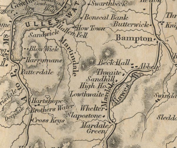 FD02NY41.jpg Outline. item:- JandMN : 100.1 Image © see bottom of page |
|
|
|
||
| evidence:- | old map:- Garnett 1850s-60s H placename:- Hayes Water |
|
| source data:- | Map of the English Lakes, in Cumberland, Westmorland and
Lancashire, scale about 3.5 miles to 1 inch, published by John
Garnett, Windermere, Westmorland, 1850s-60s.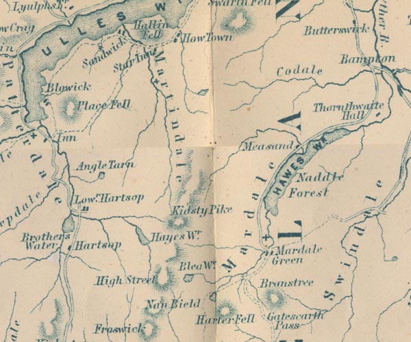 GAR2NY41.jpg "Hayes Wr." outline with shore form lines, lake or tarn item:- JandMN : 82.1 Image © see bottom of page |
|
|
|
||
| evidence:- | old text:- Martineau 1855 placename:- Hays Water item:- fish, Hayeswater; trout; fishing |
|
| source data:- | Guide book, A Complete Guide to the English Lakes, by Harriet
Martineau, published by John Garnett, Windermere, Westmorland,
and by Whittaker and Co, London, 1855; published 1855-76. goto source Page 40:- "... Hays Water, the large lonely tarn above Hartsop; where the angler delights to seclude himself, because the trout delights in it too. It is a high treat to follow up the beck from the road, winding among the farms, and then entering the solitude of the pass, till the source of the stream is found in this tarn, a mile and a-half from the main road. The little lake is overhung by High Street, so that the Roman eagles, as well as the native birds of the rocks, may have cast their shadows upon its surface. Its rushy and rocky margin is as wild a place as the most adventurous angler can ever have found himself in. ..." "..." goto sourcePage 105:- "... diverge to the left at Hartsop, to see Hays Water. The track passes among the farms, and beside the beck, between the mountains, and up till the source is reached,- the secluded tarn called Hays Water. This little lake is a mile and a-half from the main road, and the ascent is rather steep. It is the delight of the angler, because it is also the delight of the trout. It is overhung by High Street; so that perhaps the Roman eagles, as well as the native birds of the rocks, have cast their shadows upon its surface. ..." |
|
|
|
||
| evidence:- | outline view:- Black 1856 (23rd edn 1900) placename:- Ayes water |
|
| source data:- | Print, lithograph, Outline Views, Windermere - Mountains as seen from the North End
of Belle Isle, Windermere, and Mountains as seen from Biscay How, Bowness, by J Flintoft,
Keswick, Cumberland, engraved by R Mason, Edinburgh, Lothian, about 1900.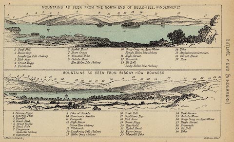 click to enlarge click to enlargeBC08E1.jpg "... 10 Gray Crag on Ayes Water ... 26 Gray Crag on Ayes Water ..." item:- JandMN : 37.4 Image © see bottom of page |
|
|
|
||
| evidence:- | outline view:- Black 1841 (3rd edn 1846) placename:- Ayes water |
|
| source data:- | Print, engraving, outline view, Mountains as seen from the North End of Belle Isle,
Windermere, and Mountains as seen from Bisket How, Bowness, by J Flintoft, Keswick,
Cumberland, engraved by R Mason, Edinburgh, about 1844.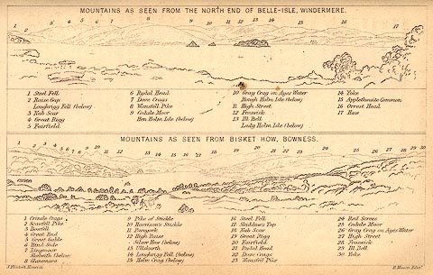 click to enlarge click to enlargeBC02E1.jpg "... 10 Gray Crag on Ayes Water ... 26 Gray Crag on Ayes Water ..." item:- JandMN : 32.3 Image © see bottom of page |
|
|
|
||
| evidence:- | old drawing:- placename:- Hays Water |
|
| source data:- | Drawing, Hays Water, Patterdale, Westmorland, by John Harper, 1840.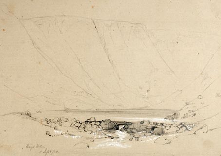 click to enlarge click to enlargePR1373.jpg View of Hayes Water taken from edge of the tarn surrounded by hills. Rocks in foreground and hills on each side. Executed in pencil with touches of white gouache on buff coloured paper. Preparatory sketch drawn on the spot by the artist. at bottom left:- "Hays Water 5 Sept./40" item:- Tullie House Museum : 2009.89.16 Image © Tullie House Museum |
|
|
|
||
| evidence:- | old print:- Rose 1832-35 |
|
| source data:- | Print, engraving, Hayswater from the Top of High-Street
Mountain, by Thomas Allom, engraved by H Adlard, 1835.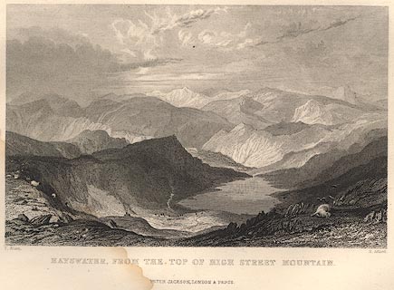 click to enlarge click to enlargeR354.jpg item:- JandMN : 66.48 Image © see bottom of page |
|
|
|
||
 Click to enlarge BQK86.jpg (taken 16.4.2009)  Click to enlarge BQK87.jpg (taken 16.4.2009) 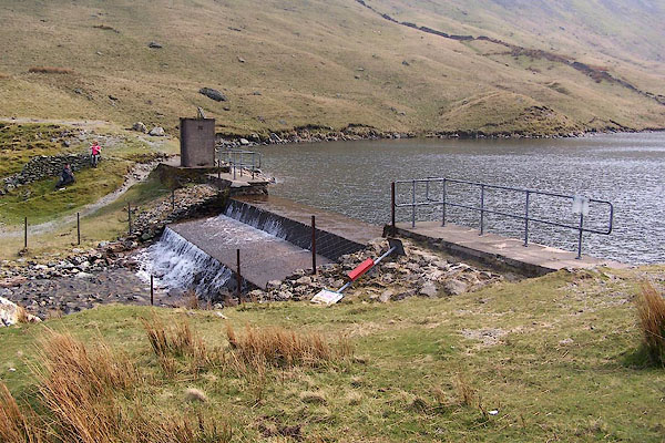 BQK84.jpg Exit dam. (taken 16.4.2009) |
||
|
|
||
Lakes Guides menu.