 Old Cumbria Gazetteer
 |
 |
|
| Hutton-in-the-Forest, Skelton | ||
| Hutton-in-the-Forest | ||
| site name:- | Inglewood Forest | |
| civil parish:- | Skelton (formerly Cumberland) | |
| county:- | Cumbria | |
| locality type:- | buildings | |
| locality type:- | garden | |
| locality type:- | castle | |
| locality type:- | pele tower | |
| locality type:- | park | |
| coordinates:- | NY46053577 | |
| 1Km square:- | NY4635 | |
| 10Km square:- | NY43 | |
|
|
||
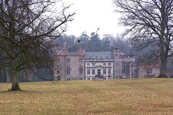 BLR70.jpg (taken 24.3.2006) |
||
|
|
||
| evidence:- | old map:- OS County Series (Cmd 49) placename:- Hutton Hall |
|
| source data:- | Maps, County Series maps of Great Britain, scales 6 and 25
inches to 1 mile, published by the Ordnance Survey, Southampton,
Hampshire, from about 1863 to 1948. "Hutton Hall" |
|
|
|
||
| evidence:- | old map:- Saxton 1579 placename:- Huton |
|
| source data:- | Map, hand coloured engraving, Westmorlandiae et Cumberlandiae Comitatus ie Westmorland
and Cumberland, scale about 5 miles to 1 inch, by Christopher Saxton, London, engraved
by Augustinus Ryther, 1576, published 1579-1645.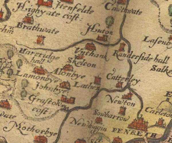 Sax9NY43.jpg Church, symbol for a parish or village, with a parish church. "Huton" There is a tree symbol just north. item:- private collection : 2 Image © see bottom of page |
|
|
|
||
| evidence:- | probably old map:- Mercator 1595 (edn?) placename:- Huton |
|
| source data:- | Map, hand coloured engraving, Northumbria, Cumberlandia, et
Dunelmensis Episcopatus, ie Northumberland, Cumberland and
Durham etc, scale about 6.5 miles to 1 inch, by Gerard Mercator,
Duisberg, Germany, about 1595.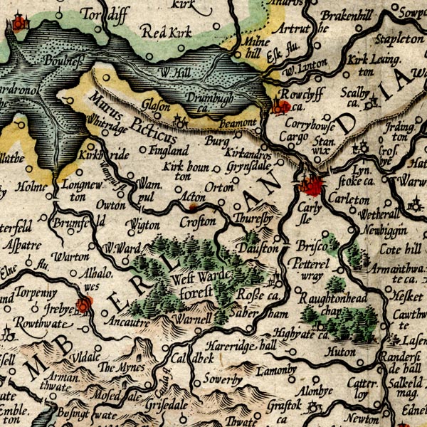 MER8CumC.jpg "Huton" circle item:- JandMN : 169 Image © see bottom of page |
|
|
|
||
| evidence:- | old map:- Speed 1611 (Cmd) placename:- Huton |
|
| source data:- | Map, hand coloured engraving, Cumberland and the Ancient Citie
Carlile Described, scale about 4 miles to 1 inch, by John Speed,
1610, published by J Sudbury and George Humble, Popes Head
Alley, London, 1611-12.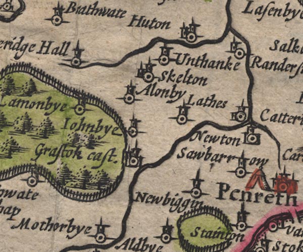 SP11NY43.jpg "Huton" circle, building, tower item:- private collection : 16 Image © see bottom of page |
|
|
|
||
| evidence:- | old map:- Jansson 1646 placename:- Huton |
|
| source data:- | Map, hand coloured engraving, Cumbria and Westmoria, ie
Cumberland and Westmorland, scale about 3.5 miles to 1 inch, by
John Jansson, Amsterdam, Netherlands, 1646.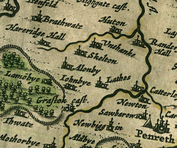 JAN3NY43.jpg "Huton" Buildings and tower. item:- JandMN : 88 Image © see bottom of page |
|
|
|
||
| evidence:- | perhaps old map:- Ogilby 1675 (plate 86) placename:- Heaton Castle |
|
| source data:- | Road strip map, uncoloured engraving, the Road from Tinmouth ...
to Carlisle, scale about 1 inch to 1 mile, by John Ogilby,
London, 1675.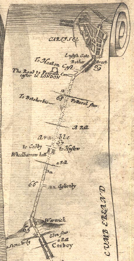 OG86m065.jpg In mile 68, Cumberland. Turning left:- "To Heaton Cast:" item:- JandMN : 73 Image © see bottom of page |
|
|
|
||
| evidence:- | old map:- Ogilby 1675 (plate 38) placename:- Hutton Hall |
|
| source data:- | Road strip map, hand coloured engraving, continuation of the
Road from London to Carlisle, scale about 1 inch to 1 mile, by
John Ogilby, London, 1675.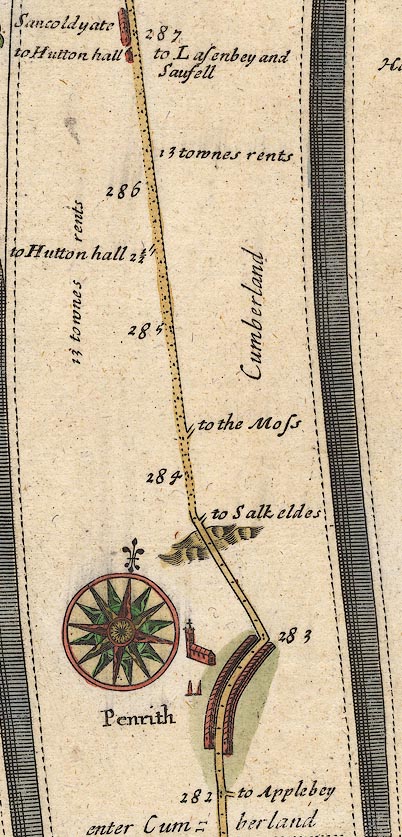 OG38m282.jpg In miles 285 and 286, Cumberland. Turnings left:- "to Hutton hall 2 1\2" And:- "to Hutton hall" item:- JandMN : 21 Image © see bottom of page |
|
|
|
||
| evidence:- | old map:- Morden 1695 (Cmd) placename:- Hutton |
|
| source data:- | Map, uncoloured engraving, Cumberland, scale about 4 miles to 1
inch, by Robert Morden, 1695, published by Abel Swale, the
Unicorn, St Paul's Churchyard, Awnsham, and John Churchill, the
Black Swan, Paternoster Row, London, 1695-1715.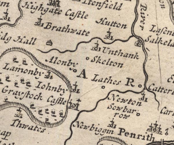 MD12NY43.jpg "Hutton" Circle, building and tower. item:- JandMN : 90 Image © see bottom of page |
|
|
|
||
| evidence:- | descriptive text:- Simpson 1746 placename:- Hutton Hall |
|
| source data:- | Atlas, three volumes of maps and descriptive text published as
'The Agreeable Historian, or the Compleat English Traveller
...', by Samuel Simpson, 1746. goto source goto source"... Hutton Hall, the late Sir George Fletcher's. ..." |
|
|
|
||
| evidence:- | old map:- Bowen and Kitchin 1760 placename:- Hutton in the Forest placename:- Hutton Hall |
|
| source data:- | Map, hand coloured engraving, A New Map of the Counties of
Cumberland and Westmoreland Divided into their Respective Wards,
scale about 4 miles to 1 inch, by Emanuel Bowen and Thomas
Kitchin et al, published by T Bowles, Robert Sayer, and John
Bowles, London, 1760. BO18NY33.jpg "Hutton in the Forest" circle; and plotted again:-  BO18NY43.jpg "Hutton Hall" circle and line item:- Armitt Library : 2008.14.10 Image © see bottom of page |
|
|
|
||
| evidence:- | old map:- Donald 1774 (Cmd) placename:- Hutton Hall |
|
| source data:- | Map, hand coloured engraving, 3x2 sheets, The County of Cumberland, scale about 1
inch to 1 mile, by Thomas Donald, engraved and published by Joseph Hodskinson, 29
Arundel Street, Strand, London, 1774. D4NY43NE.jpg "Hutton Hall / Fletcher Esqr." house, avenue of trees "PARK" outline of wall of trees; a park lake, by Hutton Hall item:- Carlisle Library : Map 2 Image © Carlisle Library |
|
|
|
||
| evidence:- | possibly old text:- Clarke 1787 placename:- Hutton Castle |
|
| source data:- | Guide book, A Survey of the Lakes of Cumberland, Westmorland,
and Lancashire, written and published by James Clarke, Penrith,
Cumberland, and in London etc, 1787; published 1787-93. goto source Page 105:- "..." "I do not find any ancient authors mention a castle here [Castlerigg], Speed, who speaks of twenty-five in Cumberland, hath found out every one I ever heard or knew of, except Kirkoswald; how that has escaped him I cannot tell. I shall here put down their names, and, as well as I can, their most ancient owners, and supposed founders." "..." goto sourcePage 106:- "..." "16. HUTTON, - By Thomas de Halton, Henry III." "..." |
|
|
|
||
| evidence:- | old print:- Clarke 1787 placename:- Hutton Hall |
|
| source data:- | building with two towers click to enlarge click to enlargeCL18.jpg "Hutton Hall" item:- Armitt Library : A6615.12 Image © see bottom of page |
|
|
|
||
| evidence:- | old text:- Camden 1789 (Gough Additions) placename:- Hutton Hall |
|
| source data:- | Book, Britannia, or A Chorographical Description of the Flourishing Kingdoms of England,
Scotland, and Ireland, by William Camden, 1586, translated from the 1607 Latin edition
by Richard Gough, published London, 1789. goto source Page 192:- "..." "From Highyate the river runs to Hutton hall the seat of a family of the same name, of whom it was purchased in the reign of James I. by the Fletchers, who, particularly sir George Fletcher, bart. who lived at it, and with whom the baronetage ended, so much improved it by buildings and plantations, that it is now one of the pleasantest seats in the county. The estate is within the Haia de Plumpton, and held of the king by the service of holding the king's stirrup when he mounts his horse in his castle of Carlisle." |
|
|
|
||
| evidence:- | possibly road book:- Cary 1798 (2nd edn 1802) placename:- Hutton Hall |
|
| source data:- | Road book, itineraries, Cary's New Itinerary, by John Cary, 181
Strand, London, 2nd edn 1802. goto source click to enlarge click to enlargeC38321.jpg page 321-322 "On r. of Hutton is Hutton Hall, Sir F. Vane, Bart." item:- JandMN : 228.1 Image © see bottom of page |
|
|
|
||
| evidence:- | perhaps old map:- Cooke 1802 placename:- Hutton |
|
| source data:- | Map, Cumberland, scale about 15.5 miles to 1 inch, by George
Cooke, 1802, bound in Gray's New Book of Roads, 1824, published
by Sherwood, Jones and Co, Paternoster Road, London, 1824. click to enlarge click to enlargeGRA1Cd.jpg "Hutton" blocks, italic lowercase text, village, hamlet, locality item:- Hampshire Museums : FA2000.62.2 Image © see bottom of page |
|
|
|
||
| evidence:- | perhaps old map:- Cooke 1802 placename:- Hutton |
|
| source data:- | Map, The Lakes, Westmorland and Cumberland, scale about 8.5
miles to 1 inch, engravedby Neele and Son, published by
Sherwood, Jones and Co, Paternoster Road, London, 1824. click to enlarge click to enlargeGRA1Lk.jpg "Hutton" blocks, italic lowercase text, village, hamlet, locality item:- Hampshire Museums : FA2000.62.5 Image © see bottom of page |
|
|
|
||
| evidence:- | probably old map:- Laurie and Whittle 1806 placename:- Hutton |
|
| source data:- | Road map, Completion of the Roads to the Lakes, scale about 10
miles to 1 inch, by Nathaniel Coltman? 1806, published by Robert
H Laurie, 53 Fleet Street, London, 1834. click to enlarge click to enlargeLw18.jpg "Hutton 289" village or other place; distance from London item:- private collection : 18.18 Image © see bottom of page |
|
|
|
||
| evidence:- | old map:- Cooper 1808 placename:- Hutton |
|
| source data:- | Map, uncoloured engraving, Cumberland, scale about 10.5 miles to
1 inch, drawn and engraved by Cooper, published by R Phillips,
Bridge Street, Blackfriars, London, 1808. click to enlarge click to enlargeCOP3.jpg "Hutton" circle; village or hamlet item:- JandMN : 86 Image © see bottom of page |
|
|
|
||
| evidence:- | old map:- Wallis 1810 (Cmd) placename:- Hutton |
|
| source data:- | Road map, hand coloured engraving, Cumberland, scale about 16
miles to 1 inch, by James Wallis, 77 Berwick Stree, Soho,
London, 1810. click to enlarge click to enlargeWL13.jpg "Hutton" village, hamlet, house, ... item:- Dove Cottage : 2009.81.10 Image © see bottom of page |
|
|
|
||
| evidence:- | probably old map:- Otley 1818 placename:- Hutton |
|
| source data:- | Map, uncoloured engraving, The District of the Lakes,
Cumberland, Westmorland, and Lancashire, scale about 4 miles to
1 inch, by Jonathan Otley, 1818, engraved by J and G Menzies,
Edinburgh, Scotland, published by Jonathan Otley, Keswick,
Cumberland, et al, 1833. OT02NY43.jpg item:- JandMN : 48.1 Image © see bottom of page |
|
|
|
||
| evidence:- | probably old map:- Hall 1820 (Cmd) placename:- Hutton |
|
| source data:- | Map, hand coloured engraving, Cumberland, scale about 21 miles
to 1 inch, engraved by Sidney Hall, published by S Leigh, 18
Strand, London, 1820-31. click to enlarge click to enlargeHA14.jpg "Hutton" circle, italic lowercase text; settlement item:- JandMN : 91 Image © see bottom of page |
|
|
|
||
| evidence:- | old map:- Ford 1839 map placename:- Hutton Hall |
|
| source data:- | Map, uncoloured engraving, Map of the Lake District of
Cumberland, Westmoreland and Lancashire, scale about 3.5 miles
to 1 inch, published by Charles Thurnam, Carlisle, and by R
Groombridge, 5 Paternoster Row, London, 3rd edn 1843. FD02NY43.jpg "Hutton Hall" Building and park. item:- JandMN : 100.1 Image © see bottom of page |
|
|
|
||
| evidence:- | old photograph:- Ullswater Steamers 1900s (edn 1903) |
|
| source data:- | Photograph, bw halftone, Hutton-in-the-Forest, Skelton, Cumberland, published in a
guide book by the Ullswater Steam Navigation Co, Penrith, Cumberland, 1903.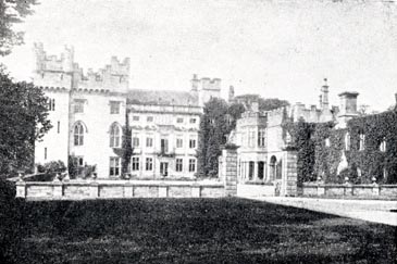 click to enlarge click to enlargeUN111.jpg item:- JandMN : 1023.11 Image © see bottom of page |
|
|
|
||
| evidence:- | database:- Listed Buildings 2010 placename:- Hutton in the Forest Hall |
|
| source data:- | courtesy of English Heritage "HUTTON IN THE FOREST HALL / / / SKELTON / EDEN / CUMBRIA / I / 73965 / NY4604835763" |
|
| source data:- | courtesy of English Heritage "Fortified tower with large country-house extensions. Late C14 or early C15 for the Hutton family with early C17 gallery by Alexander Pogmire for Henry Flecther, further 1680's extentions by Edward Addison for Sir George Fletcher, incorporating parts of the medieval and early Cl7 hall; alterations of 1824-7 by George Webster, 1845 and 1845 and 1871 by Anthony Salvin for the Fletcher Vane and Vane Families. Tower has thick dressed red sandstone walls battlemented parapet with flat roof. Other walls are of pink and red sandstone ashlar, with parapets stone battlemented, under graduated greenslate roofs with large C19 bonded red sandstone ashlar chimney stacks. 2 1/2 storeys over vaulted basement; rectangular tower with left 2 1/2-storey, 5-bay classical facade and further left C19 3-storey, 3-bay tower and rear 3-storey, 7-bay wing, the last 2 bays in mock-tower Form; right gallery wing, adjoining the medieval tower at right-angles, 2 storeys, 5 bays with further tower 2-storey, 5-bay extension. Tower has C19 entrance within C19 shouldered-arched stone porch. 2-light C15 windows with cusped heads, and left stair loops. Left angle stair turret projects above parapet. Classical facade has central quoined-surround doorway, now French window, with keyed lintel, under large cross casement window in stone architrave within pilasters and bracketed cornice; central attic swag. Cross-mullioned windows, those on ground floor under cornices and first floor alternate open triangular and segmental pediments. 2-light attic windows in eared architraves, under pilastered parapet with urn finials. Left tower has Tudor 2-light windows, those on first floor pointed, all under hoodmoulds. Angle turrets, that to left with further circular angle watch towers. Similar windows in left return wall. Rear wing has sash windows in stone architraves, the mock tower has 2-light Tudor windows. The right wing is c1640 with a polygonal central open porch under a bay window supported by clustered columns. Segment-arched openings with similar clustered columns, now with casement windows. upper-floor mullioned-and -transomed windows. The battlemented parapet was probably added by Salvin. Futher Cl9 wing has stone- surround doorway and 2-light windows. Interior has some original features including part of the angle newel staircase in the tower. Late C17 curved staircase with cherubs and aconthus leaves. Elaborate plaster ceilings, some C18, but mostly C19 by Webster and Salvin. Other rooms have C19 panelling, internal paralled shutters and C19 stone fire- places. See Hutton-in-the-Forest, Guide Book and Archaeological Journal, 1958, cxv, pp 274-250 and elevation on p 229. Also Webster family, Exhibition catalogue, Albert Hall Art Gallery, Kendal, illustration No. 14." |
|
|
|
||
| evidence:- | database:- Listed Buildings 2010 |
|
| source data:- | courtesy of English Heritage "FORMER ENTRANCE GATES AND WALLS EAST OF HUTTON IN THE FOREST HALL / / / SKELTON / EDEN / CUMBRIA / II / 73969 / NY4643935879" |
|
| source data:- | courtesy of English Heritage "Gates and wall. Early C19. Dressed red sandstone walls and ashlar piers. Double square rusticated piers, on chamfered plinths, under moulded caps and ball finials. Intervening spearhead cast iron railings and similar gates. Low stepped serpentine wall ending in piers similar to the gate piers. Wall continues for short distance in either direction beyond the piers, stepped and with chamfered coping." |
|
|
|
||
| evidence:- | database:- Listed Buildings 2010 |
|
| source data:- | courtesy of English Heritage "GARDEN WALL AND GATEWAY EAST OF HUTTON IN THE FOREST HALL / / / SKELTON / EDEN / CUMBRIA / I / 73967 / NY4608435799" |
|
| source data:- | courtesy of English Heritage "Garden wall and gateway for Hutton-in-the-Forest Hall. Late C17. Pink sandstone ashlar. Square rusticated piers with cherub finials; the flanking low walls have regularly-spaced pilasters which are carried up to project above the coping. C20 wooden railed gates. Graded for group value with Hutton-in-the-Forest Hall." |
|
|
|
||
| evidence:- | database:- Listed Buildings 2010 |
|
| source data:- | courtesy of English Heritage "DOVECOTE NORTH OF HUTTON IN THE FOREST HALL / / / SKELTON / EDEN / CUMBRIA / II / 73968 / NY4607435953" |
|
| source data:- | courtesy of English Heritage "Dovecote. Late C17 or early C18. Coursed sandstone rubble walls under greenslate roof with rebuilt wooden lantern. Octagonal dovecote. Door and small opening in chamfered stone surrounds. Interior has its original boulins and potence. Similar to dovecotes at Wreay Hall and Barrock Park." |
|
|
|
||
| evidence:- | database:- Listed Buildings 2010 |
|
| source data:- | courtesy of English Heritage "COURTYARD WALLS AND STABLE RANGES NORTH OF HUTTON IN THE FOREST HALL / / / SKELTON / EDEN / CUMBRIA / II / 73966 / NY4603135851" |
|
| source data:- | courtesy of English Heritage "Courtyard walls and stables for Hutton-in-the-Forest Hall. Early C19 by Anthony Salvin. Red sandstone rubble walls, with ashlar dressings and flush quoins, under graduated greenslate roofs with coped gables and ball finials; red sandstone ashlar chimney stacks. 2 parallel 2-storey, 4-bay stable ranges separated from the hall by an inner courtyard with linking high walls; and an outer courtyard with linking high walls, between the stable ranges. First stable range has regularly-spaced 2-light stone-mullioned windows on 2 levels. Left through segmental archway. Rear left plank doors in large plain openings. Right through archway has flanking 2-light stone-mullioned windows, under panel of arms. Second stable range has 4 large segmental-arched doorways under 2-light stone-mullioned windows. The linking partly-battlemented walls are the same height as the stables and that in the outer courtyard has a segmental-arched doorway under pediment with shield of arms and ball finials. Listed for group value with Hutton-in-the-Forest Hall." |
|
|
|
||
| evidence:- | database:- Listed Buildings 2010 |
|
| source data:- | courtesy of English Heritage "ROADSIDE WALLS NORTH OF ENTRANCE GATEWAY, NORTH WEST OF HUTTON IN THE FOREST HALL / / / SKELTON / EDEN / CUMBRIA / II / 73971 / NY4597235989" |
|
| source data:- | courtesy of English Heritage "Roadside walls. Late C18 or early C19. Pink sandstone rubble walls with ashlar dressings. Low wall with chamfered coping, flanking the Carlisle road, serpentine at the junction with the Penrith-Wigton road, ending in square ashlar piers under shaped caps with ball finials, matching those of the entrance to Hutton-in-the-Forest opposite, with which these walls are listed for group value." |
|
|
|
||
| evidence:- | database:- Listed Buildings 2010 |
|
| source data:- | courtesy of English Heritage "ENTRANCE GATEWAY AND WALLS NORTH WEST OF HUTTON IN THE FOREST / / / SKELTON / EDEN / CUMBRIA / II / 73970 / NY4596335969" |
|
| source data:- | courtesy of English Heritage "Gateway and walls forming entrance for Hutton-in-the-Forest Hall. Late C18 or early C19. Pink sandstone ashlar. Tall square rusticated gate piers with shaped caps and ball finials. Flanking serpentine walls with saddle-back coping ending in piers similar to the gate piers but without rustication. Listed for group value with Hutton-in-the-Forest Hall." |
|
|
|
||
| evidence:- | old print:- placename:- Hutton Hall |
|
| source data:- | Print, uncoloured engraving, Hutton Hall, ie Hutton-in-the-Forest, Skelton, Cumberland,
engraved by G E Jeans, early 20th century?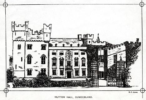 click to enlarge click to enlargePR0538.jpg printed at bottom right, centre:- "G. E. JEANS. / HUTTON HALL, CUMBERLAND." item:- Dove Cottage : 2008.107.487 Image © see bottom of page |
|
|
|
||
| evidence:- | old print:- Morris 1866-80 (vol.43 no.8) placename:- Hutton-in-the-Forest |
|
| source data:- | Print, coloured lithograph, Hutton-in-the-Forest, Skelton, Cumberland, about 1880?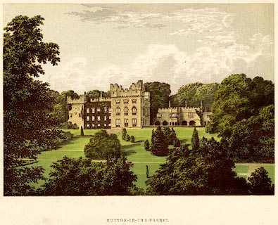 click to enlarge click to enlargePR0100.jpg printed at bottom centre:- "HUTTON-IN-THE-FOREST." item:- Dove Cottage : 2008.107.100 Image © see bottom of page |
|
|
|
||
| evidence:- | old print:- Lowther 1780s-90s |
|
| source data:- | Print, engraving, Hutton Hall ie Hutton-in-the-Forest, Skelton, Cumberland now Cumbria,
1700s.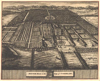 click to enlarge click to enlargeBMZ20.jpg The house and gardens and surrounding woodland are drawn in bird's eye view. The centre house and immediate wings are still visible from the front. Copied from the Knyff and Kip print? The blazon of the Fletcher arms is 'argent a cross engrailed sable between four pellets each charged with a pheon argent'; a pellet is a sable roundle. item:- Dove Cottage : Lowther.73 Image © see bottom of page |
|
|
|
||
| evidence:- | old print:- Knyff and Kip 1707 item:- coat of arms; garden |
|
| source data:- | Print, engraving, Hutton Hall ie Hutton-in-the-Forest, Skelton, Cumberland now Cumbria,
drawn by Leonard Knyff, engraved by John Kip, 1707.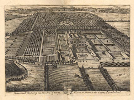 click to enlarge click to enlargeBMZ19.jpg The house and gardens and surrounding woodland are drawn in bird's eye view. The centre house and immediate wings are still visible from the front. The blazon of the Fletcher arms is 'argent a cross engrailed sable between four pellets each charged with a pheon argent'; a pellet is a sable roundle. From Britannia Illustrata, published London, 1707-1740. item:- Dove Cottage : Lowther.72 Image © see bottom of page |
|
|
|
||
| hearsay:- |
Pele tower with buildings added from 16th century to today. Features include: a gallery,
built 1630; the Cupid Staircase and Room of the 18th century; etc. |
|
| Tenure in the Middle Ages was from the king; a money rent and the duty of holding
the king's stirrup when he mounted his horse at Carlisle Castle. |
||
| This is the castle of the Green Knight in the tale of Sir Gawain. Since 1605 it has
been the home of the Inglewood Family |
||
|
|
||
| Longville, Tim &Corbett, Val (photr): 2007: Gardens of the Lake District: Lincoln,
Frances (London) |
||
|
|
||
| notes:- |
Includes a 14th century tower and hall |
|
| Perriam, D R &Robinson, J: 1998: Medieval Fortified Buildings of Cumbria: CWAAS::
ISBN 1 873124 23 6; plan |
||
|
|
||
Lakes Guides menu.