 Old Cumbria Gazetteer
 |
 |
|
| Inglewood Forest | ||
| county:- | Cumbria | |
| locality type:- | forest | |
| 10Km square:- | NY44 (etc) | |
| 10Km square:- | NY44 (etc) | |
|
|
||
| evidence:- | old map:- OS County Series (Cmd 48 4) placename:- Inglewood Forest |
|
| source data:- | Maps, County Series maps of Great Britain, scales 6 and 25
inches to 1 mile, published by the Ordnance Survey, Southampton,
Hampshire, from about 1863 to 1948. OS County Series (Cmd 49 1) OS County Series (Cmd 49 16) OS County Series (Cmd 50 14) OS County Series (Cmd 58 2) |
|
|
|
||
| evidence:- | old map:- Gough 1350s-60s placename:- Foresta de Inglewode placename:- Inglewode, Foresta de |
|
| source data:- | Map, colour photozincograph copy, reduced size facsimile, Gough
Map of Britain, scale about 28.5 miles to 1 inch, published by
the Ordnance Survey, Southampton, Hampshire, 1875.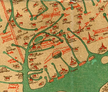 click to enlarge click to enlargeGgh1Cm.jpg "foresta de Inglewode" Written in a cartouche south of Carlisle. item:- JandMN : 33 Image © see bottom of page |
|
|
|
||
| evidence:- | old map:- Gough 1350s-60s placename:- Foresta de Inglewode placename:- Inglewode, Foresta de |
|
| source data:- | Map, lithograph facsimile, Gough Map of Britain, 20 miles to 1
inch? published by the Ordnance Survey, Southampton, Hampshire,
1935.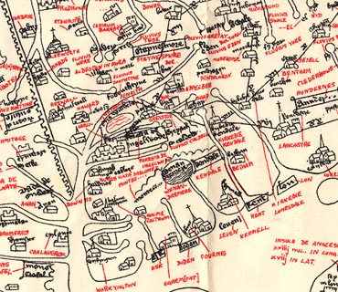 click to enlarge click to enlargeGgh2Cm.jpg "foresta de Inglewode" Written in a cartouche south of Carlisle. item:- JandMN : 34 Image © see bottom of page |
|
|
|
||
| evidence:- | old map:- Saxton 1579 placename:- Inglewood Forest |
|
| source data:- | Map, hand coloured engraving, Westmorlandiae et Cumberlandiae Comitatus ie Westmorland
and Cumberland, scale about 5 miles to 1 inch, by Christopher Saxton, London, engraved
by Augustinus Ryther, 1576, published 1579-1645.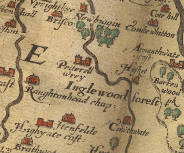 Sax9NY44.jpg "Inglewood forest" No trees with the label, but a group of trees north of Petterell wrey. item:- private collection : 2 Image © see bottom of page |
|
|
|
||
| evidence:- | perhaps old map:- Speed 1611 (Cum/EW) |
|
| source data:- | Map, hand coloured engraving, Kingdome of Great Britaine and
Ireland, scale about 36 miles to 1 inch, by John Speed, about
1610-11, published by Thomas Bassett, Fleet Street and Richard
Chiswell, St Paul's Churchyard, London, 1676?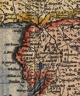 click to enlarge click to enlargeSPD6Cm.jpg a tree item:- private collection : 85 Image © see bottom of page |
|
|
|
||
| evidence:- | old map:- Speed 1611 (Cmd) placename:- Inglewood Forest |
|
| source data:- | Map, hand coloured engraving, Cumberland and the Ancient Citie
Carlile Described, scale about 4 miles to 1 inch, by John Speed,
1610, published by J Sudbury and George Humble, Popes Head
Alley, London, 1611-12.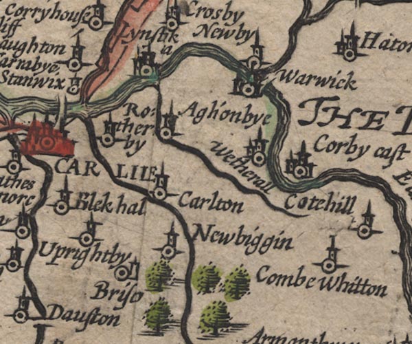 SP11NY45.jpg group of trees, S of Newbiggin 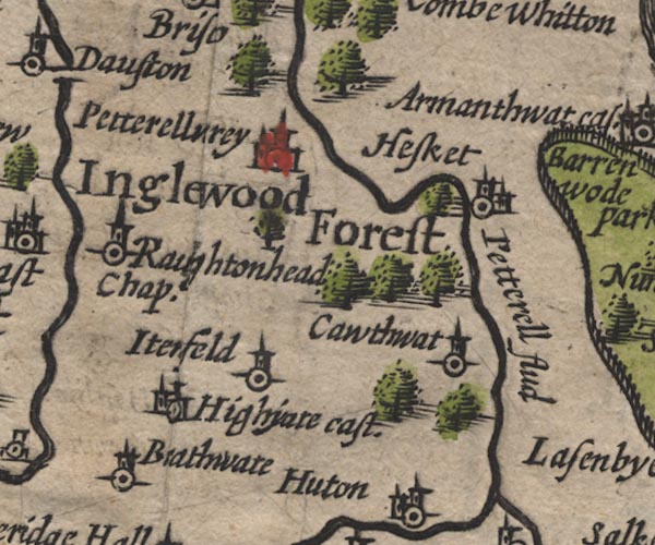 SP11NY44.jpg "Inglewood Forest" groups of tree symbols item:- private collection : 16 Image © see bottom of page |
|
|
|
||
| evidence:- | poem:- Drayton 1612/1622 text placename:- Iinglewood Forrest |
|
| source data:- | Poem, Poly Olbion, by Michael Drayton, published by published by
John Marriott, John Grismand and Thomas Dewe, and others?
London, part 1 1612, part 2 1622. goto source goto sourcepage 166:- "... Shee [Eden] with two Wood-Nymphs meets, the first is great and wilde, And Westward Forrest hight, the other but a childe, Compared with her Phere, and Inglewood is cald, Both in their pleasant Scites, most happily instald." |
|
|
|
||
| evidence:- | old map:- Drayton 1612/1622 placename:- Inglewood Forest |
|
| source data:- | Map, hand coloured engraving, Cumberlande and Westmorlande, by
Michael Drayton, probably engraved by William Hole, scale about
4 or 5 miles to 1 inch, published by John Mariott, John
Grismand, and Thomas Dewe, London, 1622.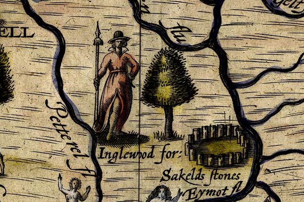 DRY508.jpg "Inglewood for:" Tree, huntress carrying a spear. item:- JandMN : 168 Image © see bottom of page |
|
|
|
||
| evidence:- | old map:- Jansson 1646 placename:- Inglewood Forest |
|
| source data:- | Map, hand coloured engraving, Cumbria and Westmoria, ie
Cumberland and Westmorland, scale about 3.5 miles to 1 inch, by
John Jansson, Amsterdam, Netherlands, 1646.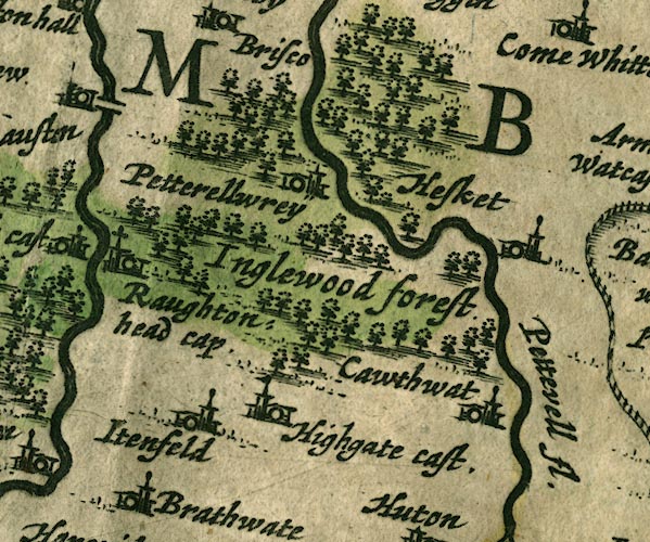 JAN3NY44.jpg "Inglewood forest" Group of tree symbols. item:- JandMN : 88 Image © see bottom of page |
|
|
|
||
| evidence:- | old map:- Ogilby 1675 (plate 38) placename:- Englewood Forest |
|
| source data:- | Road strip map, hand coloured engraving, continuation of the
Road from London to Carlisle, scale about 1 inch to 1 mile, by
John Ogilby, London, 1675.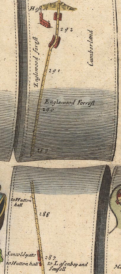 OG38m287.jpg In mile 290, Cumberland. "Englewood Forest" labelled both sides of the road. item:- JandMN : 21 Image © see bottom of page |
|
|
|
||
| evidence:- | old map:- Morden 1695 (Cmd) placename:- Inglewood Forest |
|
| source data:- | Map, uncoloured engraving, Cumberland, scale about 4 miles to 1
inch, by Robert Morden, 1695, published by Abel Swale, the
Unicorn, St Paul's Churchyard, Awnsham, and John Churchill, the
Black Swan, Paternoster Row, London, 1695-1715.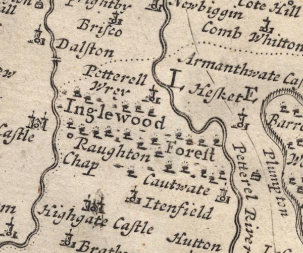 MD12NY44.jpg "Inglewood Forest" Forest, tree symbols. item:- JandMN : 90 Image © see bottom of page |
|
|
|
||
| evidence:- | old map:- Bowen 1720 (plate 94) placename:- Engelwood Forest |
|
| source data:- | Strip maps, uncoloured engravings, road maps, The Road from
London to Carlisle, scale about 2 miles to 1 inch, with sections
in Lancashire and Westmorland, published by Emanuel Bowen, St
Katherines, London, 1720.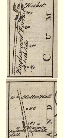 B094m287.jpg At mile 289-292 alongside road. item:- Dove Cottage : 2007.38.100 Image © see bottom of page |
|
|
|
||
| evidence:- | possibly descriptive text:- Simpson 1746 placename:- Plompton Park item:- deer; hunting |
|
| source data:- | Atlas, three volumes of maps and descriptive text published as
'The Agreeable Historian, or the Compleat English Traveller
...', by Samuel Simpson, 1746. goto source "Upon the Banks of the little River Peterell, lay Plompton-Park, a very large Piece of Ground, and formerly set apart by the Kings of England for the Keeping of Deer for their own Use and Hunting, with which it was so well stocked once, that King Edward I. is said to have killed 200 Bucks in one Day in hunting in this Forest." |
|
|
|
||
| evidence:- | old map:- Bowen and Kitchin 1760 placename:- Englewood Forest |
|
| source data:- | Map, hand coloured engraving, A New Map of the Counties of
Cumberland and Westmoreland Divided into their Respective Wards,
scale about 4 miles to 1 inch, by Emanuel Bowen and Thomas
Kitchin et al, published by T Bowles, Robert Sayer, and John
Bowles, London, 1760.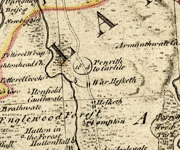 BO18NY44.jpg "Englewood Forest" trees item:- Armitt Library : 2008.14.10 Image © see bottom of page |
|
|
|
||
| evidence:- | old text:- Clarke 1787 placename:- Englewood item:- archery |
|
| source data:- | Guide book, A Survey of the Lakes of Cumberland, Westmorland,
and Lancashire, written and published by James Clarke, Penrith,
Cumberland, and in London etc, 1787; published 1787-93. goto source Page xi:- "I cannot quit this subject, without taking notice of that superiority in archery which the English have always boasted, and which has had so material an effect in almost all the battles which they formerly fought, against different modes of discipline, and different nations. Whatever effect political regulations might have had in preserving this superiority, or whatever the consequent practice of it as an amusement may have done, I think I may safely aver, that the custom of poaching occasioned by the severity of the game-laws established by the conqueror, had no small effect in preserving it. It was this that produced so many noted archers and outlaws in the forest of Englewood as well as that of Sherwood. For, not to mention Adam Bell and his partners, tradition still preserves the name of Watty of Croglin, Woodhead Andrew, Robin Oth'moors, Gruff Elleck (Alexander,) and of several others, as of persons distinguished in that line, even amongst a people who were almost to a man of the same stamp. ..." |
|
|
|
||
| evidence:- | old text:- Clarke 1787 placename:- Englyshe Wood item:- hunting; bow and arrow; deer; ballad |
|
| source data:- | Guide book, A Survey of the Lakes of Cumberland, Westmorland,
and Lancashire, written and published by James Clarke, Penrith,
Cumberland, and in London etc, 1787; published 1787-93. goto source Page 107:- "..." "The following old Ballad hath been printed in Dr PERCY'S Poems, addressed to the COUNTESS of NORTHUMBERLAND, in 1775," "MERY yt was yn grene forets, among the leaves grene, Whereas men hunt east and west, wyth bowes and arrowes kene. To ryse the dere out of theyr denne suche syghts hath oft bene sene, As by thre yemen of the north countrey, by them yt ys I meane." "The one of them hyght Adam Bell, the other Clym of the Clough; The thyrd was Wyllyam of Cloudesle, an archer good ynough; They were outlaw'd for venyson, these yemen every chone; They swore them brethren on a day to Englyshe wood for to gone." "... ..." The ballad is very long ... goto sourcePage 115:- "..." "SOME will have these three mentioned in the above old ballad to have been contemporary with Robin Hood's father, as the pedigree writer of Robin says:" "The father of Robin a forester was, and he shot in a lusty long bow, Two North Country miles and an inch at a shot, as the Pindar of Wakefield does know. For he brought Adam Bell, and Clim of the Clough, and William a Cloudeslee, To shoot with our forester for forty merk, and our forester beat them all three." |
|
|
|
||
| evidence:- | old text:- Camden 1789 (Gough Additions) placename:- Forest of Englewood item:- disforesting; deer |
|
| source data:- | Book, Britannia, or A Chorographical Description of the Flourishing Kingdoms of England,
Scotland, and Ireland, by William Camden, 1586, translated from the 1607 Latin edition
by Richard Gough, published London, 1789. goto source Page 189:- "..." "At the Conquest the manor of Penrith and the forest of Englewood, in which it is situate, were in the possession of the Scots, who were soon after dispossessed, but kept up their claim to the three counties of Cumberland, Westmorland, and Northumberland, to which king John seems to have consented on payment of 15,000 marks by William king of Scotland, and an intermarriage of John with one of his daughters; but these claims were renounced by king Alexander to Henry III. on the latter's granting him 200 librates of land in this county or Northumberland, in any town where there is no castle, or in places in the said counties. Alexander's son and successor married Henry's daughter, and had the said land confirmed to him, and a bond of 5000 marks of silver for her marriage portion. Hence these lands had the name of the queen's haims or desmenes. They were Penrith, with the hamlets of Langwathby, Scotby, Great Salkeld, and Carleton. Baliol held them till Edward I. quarreling with him seized them, and granted them to Anthony Bek, bishop of Durham, from whom the parliament took them, and they remained in the crown. Richard II. gave them to John duke of Bretaign and Richmond, and shortly after to Ralph Neville of Westmorland, whose heir Richard of Warwick, being slain at Barnet 11 Edward IV. the whole estate for want of heirs male reverted to the crown, and continued as part of the royal desmene till William III. gave the honour of Penrith and all its dependances with the appurtenances within the forest of Englewood, whose boundaries may be seen in Burn, III. 522. to William Bentink, afterwards created earl of Portland, and they are still held by his great grandson William Henry duke of Portland." "..." goto sourcePage 189:- "..." ""Yn the forest of Ynglewood, vi myls from Caerluel, appere ruins of a castel, called Castle Luen."" "Englewood forest was disforested by Henry VIII. who allowed the inhabitants greater liberty and freer use of it. Hutton and Edenhall were parishes in it t. Henry I. who gave them to Carlisle church, and Wedderhall, Warwick, Lazonby, Skelton, Sowerby, St. Mary's, St. Cuthbert's, Carlisle, and Dalston, were all included in it, or bordering on it, as early as the Conquest. It was 16 miles long from Penrith to Carlisle; and Edward I. hunting in it is said to have killed 200 bucks in one day. It is now a dreary moor with high distant hills on both sides, and a few stone farm houses and cottages on the road side." |
|
|
|
||
| evidence:- | road book:- Cary 1798 (2nd edn 1802) placename:- Inglewood Forest |
|
| source data:- | Road book, itineraries, Cary's New Itinerary, by John Cary, 181
Strand, London, 2nd edn 1802. goto source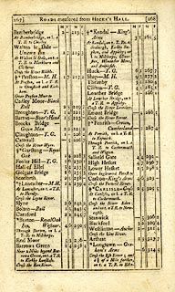 click to enlarge click to enlargeC38267.jpg page 267-268 "Over Inglewood Forest to ..." goto source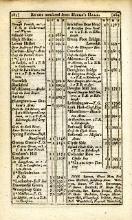 click to enlarge click to enlargeC38283.jpg page 283-284 "Over Inglewood Forest to ..." item:- JandMN : 228.1 Image © see bottom of page |
|
|
|
||
| evidence:- | old map:- Garnett 1850s-60s H placename:- Inglewood Forest |
|
| source data:- | Map of the English Lakes, in Cumberland, Westmorland and
Lancashire, scale about 3.5 miles to 1 inch, published by John
Garnett, Windermere, Westmorland, 1850s-60s.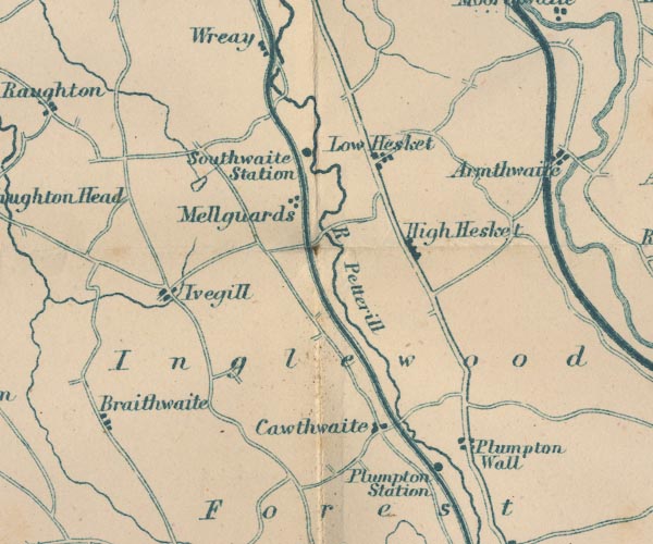 GAR2NY44.jpg "Inglewood Forest" area item:- JandMN : 82.1 Image © see bottom of page |
|
|
|
||
| evidence:- | old text:- Harper 1907 placename:- |
|
| source data:- | Guidebook, The Manchester and Glasgow Road, by Charles G Harper,
published by Chapman and Hall Ltd, London, 1907. HP01p136.txt Page 136:- "[on the road, Penrith to Carlisle] ... Of the ancient Inglewood Forest, and the alarming wild boars that frequented it, there are no signs, ..." |
|
|
|
||
| hearsay:- |
In the 15th century there was a thorn tree near Hesket in the Forest where tenants
of Inglewood Forest would meet in a Forest Court. |
|
|
|
||
| hearsay:- |
||
| "a goodly great forest full of woods, red deer and fallow, wild boar and all manner
of wild beasts" |
||
|
|
||
| story:- |
Sir Gawain rode through this forest on his way to the Green Knight:- |
|
| "By a mount on the morn merrily he rides Into a forest full deep, that fairly was wild, High hills on each a half, and holtwoods under Of hore oaks full huge a hundred together; The hazel and the hawthorn were harled all together, With rough ragged moss arrayed everywhere, With many birds unblythe upon bare twigs, That piteously there piped for pain of the cold." |
||
|
|
||
Lakes Guides menu.