 Old Cumbria Gazetteer
 |
 |
|
| Irish Gate, Carlisle | ||
| gone | ||
| Irish Gate | ||
| Caldewgate | ||
| site name:- | City Walls | |
| locality:- | Carlisle | |
| civil parish:- | Carlisle (formerly Cumberland) | |
| county:- | Cumbria | |
| locality type:- | town gate | |
| coordinates:- | NY39655605 (?) | |
| 1Km square:- | NY3956 | |
| 10Km square:- | NY35 | |
|
|
||
| evidence:- | old map:- OS County Series (Cmd 23 3) placename:- Irish Gate |
|
| source data:- | Maps, County Series maps of Great Britain, scales 6 and 25
inches to 1 mile, published by the Ordnance Survey, Southampton,
Hampshire, from about 1863 to 1948. "Irish Gate (Site of)" |
|
|
|
||
| evidence:- | old map:- Ogilby 1675 (plate 62) placename:- English Gate |
|
| source data:- | Raod strip map, uncoloured engraving, the Road from Carlisle to
Barwick, scale about 1 inch to 1 mile, by John Ogilby, London,
1675.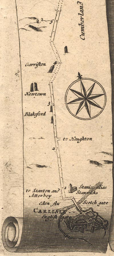 OG62m000.jpg In mile 0, Cumberland. "English gate" labelled in the position of Irish Gate at Carlisle. item:- JandMN : 83 Image © see bottom of page |
|
|
|
||
| evidence:- | old map:- Ogilby 1675 (plate 86) |
|
| source data:- | Road strip map, uncoloured engraving, the Road from Tinmouth ...
to Carlisle, scale about 1 inch to 1 mile, by John Ogilby,
London, 1675.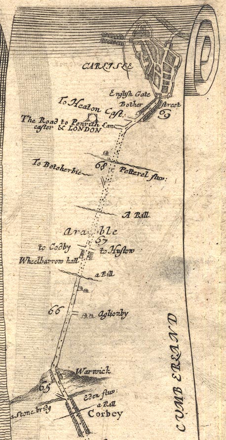 OG86m065.jpg In mile 69, Cumberland. Town gate on the left (west) of Carlisle. item:- JandMN : 73 Image © see bottom of page |
|
|
|
||
| evidence:- | old map:- Ogilby 1675 (plate 96) placename:- Irish Gate |
|
| source data:- | Road strip map, hand coloured engraving, the Road from Kendal to
Cockermouth, and the Road from Egremond to Carlisle, scale about
1 inch to 1 mile, by John Ogilby, London, 1675.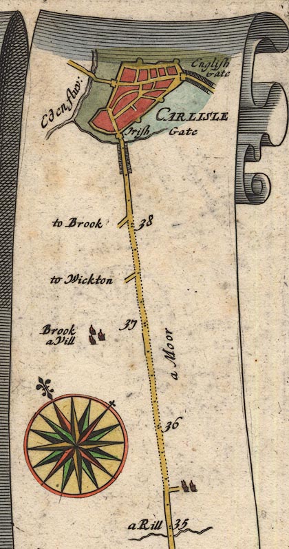 OG96Bm35.jpg In mile 38, Cumberland. "Irish Gate" at the entrance through the town walls. item:- JandMN : 22 Image © see bottom of page |
|
|
|
||
| evidence:- | old map:- Ogilby 1675 (plate 38) |
|
| source data:- | Road strip map, hand coloured engraving, continuation of the
Road from London to Carlisle, scale about 1 inch to 1 mile, by
John Ogilby, London, 1675.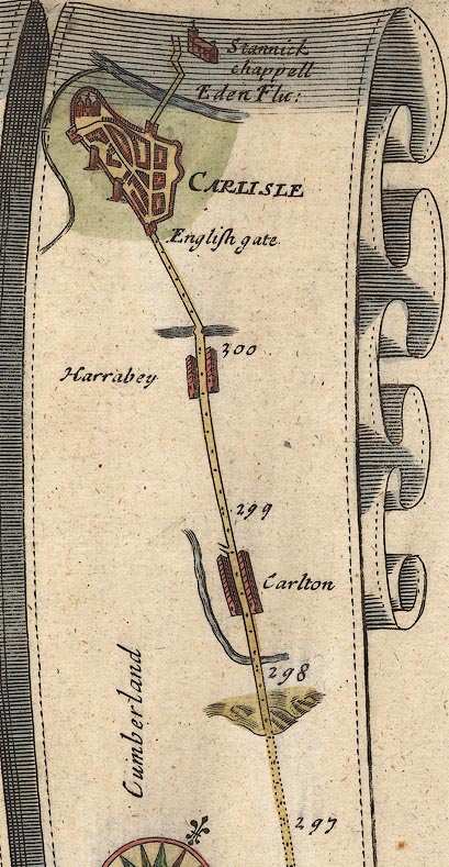 OG38m297.jpg In mile 301, Cumberland. Gate on the town walls. item:- JandMN : 21 Image © see bottom of page |
|
|
|
||
| evidence:- | descriptive text:- Fiennes 1698 placename:- Irish Gate |
|
| source data:- | Travel book, manuscript record of Journeys through England
including parts of the Lake District, by Celia Fiennes, 1698. "... there are 3 gates to the town [Carlisle] ... the other the Irish which leads on to White haven and Cokermouth," |
|
|
|
||
| evidence:- | old text:- Ogilby 1699 (edn 1712) placename:- Caldo Gate placename:- Irish Gate |
|
| source data:- | Road book, itineraries and map, The Traveller's Guide, by John
Ogilby, published by Abel Swall, Tim Child, White Hart, and R
Knaplock, the Angel and Crown, St Paul's Churchyard, London,
1699. OGY7p072.txt page 72 "... Carlile ... having 3 Gates, viz. the Caldo or Irish-Gate, Bother or English-Gate, and Rickard or Scotch-Gate." |
|
|
|
||
| evidence:- | old map:- Bowen 1720 (plate 261) placename:- Irish Gate |
|
| source data:- | Road strip map, uncoloured engraving, pl.261, the end of the
road from Kendal to Cockermouth and the road from Egremont to
Carlisle, scale about 2 miles to 1 inch, published by Emanuel
Bowen, St Katherines, London, 1720.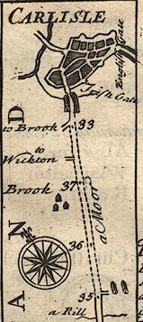 B261m35.jpg The Egremont road shown entering Carlisle by Irish Gate; English Gate to right. item:- Dove Cottage : Lowther.36 Image © see bottom of page |
|
|
|
||
| evidence:- | old text:- Gents Mag placename:- Caldo Gate placename:- Irish Gate |
|
| source data:- | Magazine, The Gentleman's Magazine or Monthly Intelligencer or
Historical Chronicle, published by Edward Cave under the
pseudonym Sylvanus Urban, and by other publishers, London,
monthly from 1731 to 1922. goto source goto sourceGentleman's Magazine 1745 p.674 "..." "It is at present a wealthy and populous place, the houses are well built, and city walled in, having three gates, viz. the Caldo or Irish gate on the S. West, the Bother or English gate on the South, and the Rickard or Scotch gate towards the North. ..." "..." "This observation is made by the reverend compiler of the Magna Britannia antiqua et nova, from whom the foregoing description is taken, except a correction of him with regard to the situation of the place, all our news papers following this writer (who might have informed himself better from honest Speed) having turned the city about and placed the English gate in the West and the Irish in the South." |
|
|
|
||
| evidence:- | old map:- Smith 1752 placename:- Irish Gate |
|
| source data:- | Map, hand coloured engraving, or manuscript? Map of the Soccage
Lands at Carlisle, scale about 27 ins to 1 mile, by George
Smith, 1752. click to enlarge click to enlargeM005P.jpg "Irish Gate" item:- Carlisle Library : Map 121 Image © Carlisle Library |
|
|
|
||
| evidence:- | old map:- Donald 1774 (Cmd) placename:- Irish Gate |
|
| source data:- | Map, hand coloured engraving, 3x2 sheets, The County of Cumberland, scale about 1
inch to 1 mile, by Thomas Donald, engraved and published by Joseph Hodskinson, 29
Arundel Street, Strand, London, 1774. D43956Q.jpg "Irish Gate" location of town gate item:- Carlisle Library : Map 2 Image © Carlisle Library |
|
|
|
||
| evidence:- | old text:- Camden 1789 (Gough Additions) placename:- French Gate placename:- Calden Gate placename:- West Gate |
|
| source data:- | Book, Britannia, or A Chorographical Description of the Flourishing Kingdoms of England,
Scotland, and Ireland, by William Camden, 1586, translated from the 1607 Latin edition
by Richard Gough, published London, 1789. goto source Page 193:- "..." ""The City of Cairluell ... is walled with a right fair strong wall ... In the wall be three gates Bocher or S. Calden or W. and Richard or N. ..." "... The city has three gates, the French, English, and Scotch; ..." |
|
|
|
||
| evidence:- | descriptive text:- Baker 1802 placename:- |
|
| source data:- | Perspective road map with sections in Lancashire, Westmorland,
and Cumberland, by J Baker, London 1802. Page 27:- "... [Carlisle] hath three entrances by gates, strongly fortified; that to the west is called the English gate, one to the south is called the Irish gate, and another nortward is called the Scotch gate. ..." |
|
|
|
||
| evidence:- | old print:- Thurnam 1835 |
|
| source data:- | Print, uncoloured lithograph, Carlisle from Primrose Bank, Cumberland, drawn by M
E Nutter, lithographed by P Gauci, published by Charles Thurnam, Carlisle, Cumberland,
by Ackermann and Co, by Hodgson, Boys, and Graves, and by Charles Tilt, London, 1835.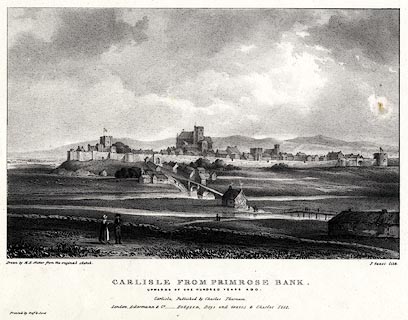 click to enlarge click to enlargeTHM102.jpg Included in Carlisle in the Olden Time. printed at bottom:- "Drawn by M. E. Nutter from the original sketch. / P. Gauci lith. / CARLISLE FROM PRIMROSE BANK. / UPWARDS OF ONE HUNDRED YEARS AGO. / Carlisle, Published by Charles Thurnam. / London. Ackermann & Co. - Hodgson, Boys, and Graves & Charles Tilt. / Printed by Graf &Soret." item:- Dove Cottage : 2008.123.2 Image © see bottom of page |
|
|
|
||
| evidence:- | old print:- Thurnam 1835 placename:- Irish Gate |
|
| source data:- | Print, uncoloured lithograph, The Irish Gate, Carlisle, Cumberland, drawn by M E Nutter,
lithographed by C Haghe, published by Charles Thurnam, Carlisle, Cumberland, by Ackermann
and Co, by Hodgson, Boys, and Graves, and by Charles Tilt, London, 1835.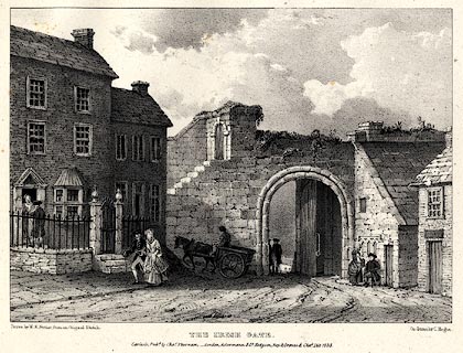 click to enlarge click to enlargeTHM105.jpg Included in Carlisle in the Olden Time. printed at bottom:- "Drawn by M. E. Nutter from an Original Sketch. / On stone by C. Haghe. / THE IRISH GATE. / Carlisle, Pub'd by Chas. Thurnam,- London, Ackermann & Co. Hodgson, Boys, and Graves & Chas. Tilt. 1835." item:- Dove Cottage : 2008.123.5 Image © see bottom of page |
|
|
|
||
| evidence:- | old painting:- |
|
| source data:- | Painting, watercolour, The Irish Gate, Carlisle, Cumberland, by W Hetherington, about
1880.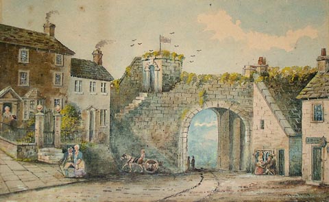 click to enlarge click to enlargePR1356.jpg The Irish Gate stands in centre of composition, its studded doors thrown open, adjoined to right by a low sandstone building with a pitched roof. To left stand two townhouses beside which a horse and cart are partially visible. To right a man and woman walk along the pavement in front of the two town houses. Another couple can be seen to the right of the gate. Based on an original watercolour by Robert Carlyle dated 1791. signed at bottom right:- "W Hetherington" item:- Tullie House Museum : 2004.1.19 Image © Tullie House Museum |
|
|
|
||
| evidence:- | old print:- placename:- Irish Gate item:- cart; costume |
|
| source data:- | Print, lithograph, The Irish Gate, Carlisle, Cumberland drawn by Matthew Ellis Nutter,
1833, engraved by C Haghe, published by Charles Thurnam, Carlisle, Cumberland, and
by Charles Tilt, London, 1835.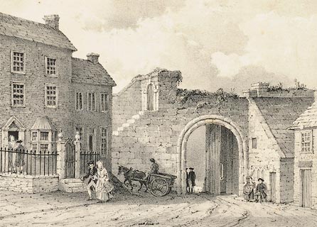 click to enlarge click to enlargePR0971.jpg Irish Gate stands in centre of composition, its studded doors thrown open, adjoined to right by a low sandstone building with a pitched roof outside which a couple converse. To left of composition stand two townhouses; a couple stand conversing on the doorstep of the left house whilst beside the other a horse and cart pass by. To left of foreground a couple walk along the pavement. The work was executed as one of a series of 17 copies of works by Robert Carlyle and published by Thurnam as Carlisle in the Olden Time. inscribed at bottom left on print:- "Drawn by M.E. Nutter, from an Original Sketch." printed at bottom centre:- "THE IRISH GATE Carlisle, Pubd by Chas Thurnam, - London, Ackerman and Co., Hodgson, Boys and Graves and Chas Tilt 1835." inscribed at bottom right on print:- "On Stone by C Haghe." item:- Tullie House Museum : 1956.24 Image © Tullie House Museum |
|
|
|
||
| evidence:- | old painting:- placename:- Irish Gate |
|
| source data:- | Painting, watercolour, The Irish Gate, Carlisle, Cumberland, by Robert Carlyle snr,
1791.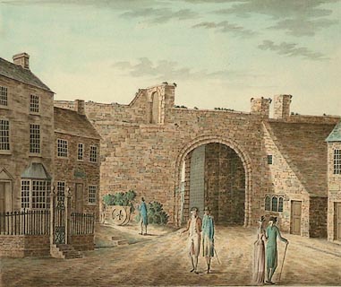 click to enlarge click to enlargePR0907.jpg the Irish Gate stands in centre of composition, its studded doors thrown open, adjoined to right by a low sandstone building with a pitched roof. To left stand two townhouses beside which a horse and cart are partially visible. In centre foreground four figures walk along the cobbled roadway leading towards the Gate; two gentlemen conversing, and a couple who have their backs towards the viewer. One of a set of 11 original drawings for proposed aquatints The Antiquities of the City of Carlisle, 1791 This is one of 17 of Carlyle's works copied by Matthew Ellis Nutter and published as lithographs in 1835 by Thurnam as Carlisle in the Olden Time inscribed at bottom centre:- "THE IRISH GATE, CARLISLE." item:- Tullie House Museum : 1935.80.2 Image © Tullie House Museum |
|
|
|
||
| evidence:- | old print:- |
|
| source data:- | Print, uncoloured engraving, Prospect of the City of Carlisle, Cumberland, published
late 18th century.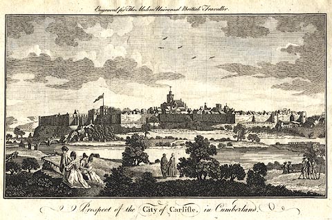 click to enlarge click to enlargePR0385.jpg Included in The Modern Universal British Traveller. The city has town walls and gates. printed at top:- "Engraved for The Modern Universal British Traveller" printed at bottom:- "Prospect of the CITY of CARLISLE, in Cumberland." item:- Dove Cottage : 2008.107.385 Image © see bottom of page |
|
|
|
||
| notes:- |
gateway, demolished |
|
| Perriam, D R &Robinson, J: 1998: Medieval Fortified Buildings of Cumbria: CWAAS::
ISBN 1 873124 23 6; plan and illustrations |
||
|
|
||
Lakes Guides menu.