 Old Cumbria Gazetteer
 |
 |
|
| Islekirk Hall, Westward | ||
| Islekirk Hall | ||
| civil parish:- | Westward (formerly Cumberland) | |
| county:- | Cumbria | |
| locality type:- | buildings | |
| coordinates:- | NY25984455 | |
| 1Km square:- | NY2544 | |
| 10Km square:- | NY24 | |
|
|
||
| evidence:- | possibly descriptive text:- Simpson 1746 placename:- Iselkirk |
|
| source data:- | Atlas, three volumes of maps and descriptive text published as
'The Agreeable Historian, or the Compleat English Traveller
...', by Samuel Simpson, 1746. goto source goto source"... Islekirk, Mr. Fetherstone's. ..." |
|
|
|
||
| evidence:- | old map:- Donald 1774 (Cmd) placename:- Islekirk |
|
| source data:- | Map, hand coloured engraving, 3x2 sheets, The County of Cumberland, scale about 1
inch to 1 mile, by Thomas Donald, engraved and published by Joseph Hodskinson, 29
Arundel Street, Strand, London, 1774.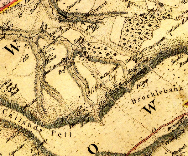 D4NY24SE.jpg "Islekirk / Lucock Esq" house item:- Carlisle Library : Map 2 Image © Carlisle Library |
|
|
|
||
| evidence:- | old painting:- |
|
| source data:- | Painting, watercolour, Islekirk Hall, Westward, Cumberland, by Samuel Bough, 1849.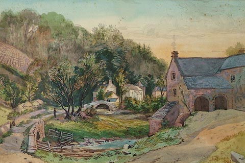 click to enlarge click to enlargePR1165.jpg Sunset scene; to right of foreground a stone farmhouse stands from which a winding pathway leads across a stream towards the village beyond. A single figure stands beneath the shade of a tree beside it, in middle distance. To left of composition rises a steep hill, partially ploughed, adjoined by woodland. Lengthy shadows are cast throughout. signed &dated at bottom right:- "S Bough 1849" item:- Tullie House Museum : 1976.53.4 Image © Tullie House Museum |
|
|
|
||
| evidence:- | database:- Listed Buildings 2010 placename:- Islekirk Hall |
|
| source data:- | courtesy of English Heritage "ISLEKIRK HALL / / / WESTWARD / ALLERDALE / CUMBRIA / II[star] / 416212 / NY2594344526" |
|
|
|
||
| notes:- |
Supposed pele tower and 16th century hall. |
|
| Perriam, D R &Robinson, J: 1998: Medieval Fortified Buildings of Cumbria: CWAAS::
ISBN 1 873124 23 6 |
||
|
|
||
Lakes Guides menu.