 Old Cumbria Gazetteer
 |
 |
|
| Kendal Castle, Kendal | ||
| Kendal Castle | ||
| Kirkby Kendal Castle | ||
| locality:- | Kendal | |
| civil parish:- | Kendal (formerly Westmorland) | |
| county:- | Cumbria | |
| locality type:- | castle | |
| coordinates:- | SD52209240 | |
| 1Km square:- | SD5292 | |
| 10Km square:- | SD59 | |
|
|
||
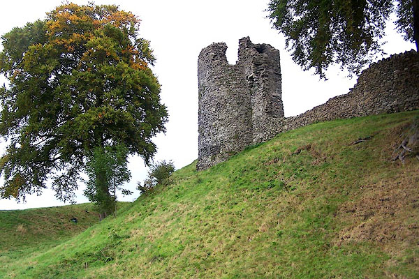
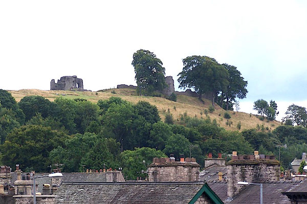 BJT09.jpg (taken 19.8.2005) 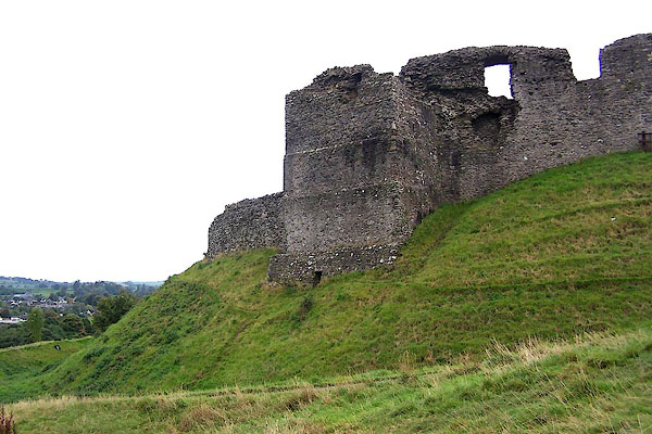 BJX10.jpg (taken 3.10.2005) |
||
|
|
||
| evidence:- | old map:- OS County Series (Wmd 38 8) placename:- Kendal Castle |
|
| source data:- | Maps, County Series maps of Great Britain, scales 6 and 25
inches to 1 mile, published by the Ordnance Survey, Southampton,
Hampshire, from about 1863 to 1948. |
|
|
|
||
| evidence:- | old map:- Saxton 1579 placename:- Kendall Castle |
|
| source data:- | Map, hand coloured engraving, Westmorlandiae et Cumberlandiae Comitatus ie Westmorland
and Cumberland, scale about 5 miles to 1 inch, by Christopher Saxton, London, engraved
by Augustinus Ryther, 1576, published 1579-1645.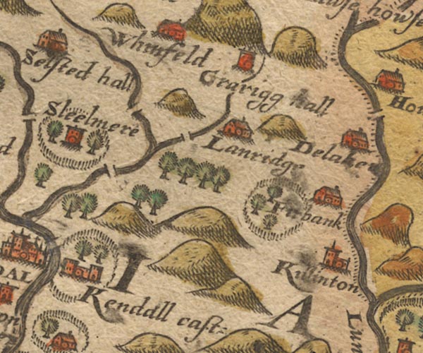 Sax9SD59.jpg Building with two towers, symbol for a castle. "Kendall cast:" Castle, in a park, fence palings, trees. item:- private collection : 2 Image © see bottom of page |
|
|
|
||
| evidence:- | old map:- Speed 1611 |
|
| source data:- | Map, hand coloured engraving, The Countie Westmorland and
Kendale the Cheif Towne, scale about 2.5 miles to 1 inch, by
John Speed, 1610, published by George Humble, Popes Head Alley,
London, 1611-12.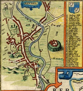 click to enlarge click to enlargeSP14Mk.jpg "W The Castle" walls, 7 or 8 towers, on a mound item:- Armitt Library : 2008.14.5 Image © see bottom of page |
|
|
|
||
| evidence:- | old map:- Speed 1611 (Wmd) |
|
| source data:- | Map, hand coloured engraving, The Countie Westmorland and
Kendale the Cheif Towne, scale about 2.5 miles to 1 inch, by
John Speed, 1610, published by George Humble, Popes Head Alley,
London, 1611-12.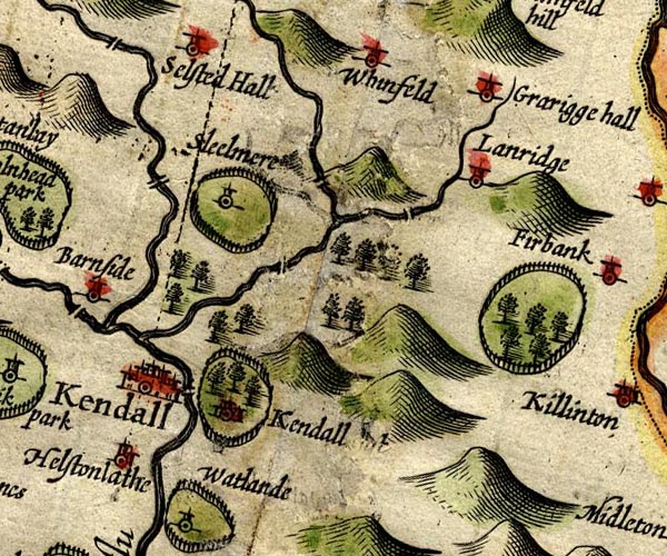 SP14SD59.jpg "Kendal [ t]" circle, buildings, tower, and a ring of fence palings and trees for a park item:- Armitt Library : 2008.14.5 Image © see bottom of page |
|
|
|
||
| evidence:- | old map:- Jansson 1646 placename:- Kendall Castle |
|
| source data:- | Map, hand coloured engraving, Cumbria and Westmoria, ie
Cumberland and Westmorland, scale about 3.5 miles to 1 inch, by
John Jansson, Amsterdam, Netherlands, 1646.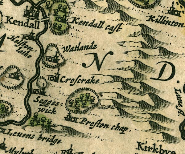 JAN3SD58.jpg "Kendall Castle" Buildings and tower with flag, in a ring of fence palings with trees. item:- JandMN : 88 Image © see bottom of page |
|
|
|
||
| evidence:- | old map:- Ogilby 1675 (plate 96) |
|
| source data:- | Road strip map, hand coloured engraving, the Road from Kendal to
Cockermouth, and the Road from Egremond to Carlisle, scale about
1 inch to 1 mile, by John Ogilby, London, 1675. OG96m000.jpg In mile 0, Westmoreland. "ye Castle" castle walls around the castle building. item:- JandMN : 22 Image © see bottom of page |
|
|
|
||
| evidence:- | old map:- Ogilby 1675 (plate 38) |
|
| source data:- | Road strip map, hand coloured engraving, continuation of the
Road from London to Carlisle, scale about 1 inch to 1 mile, by
John Ogilby, London, 1675. OG38m252.jpg In mile 256, Westmoreland. "the Castle" drawing of castle walls around the castle building. item:- JandMN : 21 Image © see bottom of page |
|
|
|
||
| evidence:- | old map:- Morden 1695 (Wmd) placename:- Kendale Castle |
|
| source data:- | Map, hand coloured engraving, Westmorland, scale about 2.5 miles to 1 inch, by Robert
Morden, published by Abel Swale, the Unicorn, St Paul's Churchyard, Awnsham, and John
Churchill, the Black Swan, Paternoster Row, London, 1695.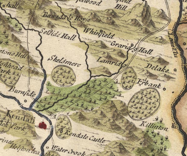 MD10SD59.jpg "Kendale Castle" Circle, tower, in a park - ring of fence palings, trees. item:- JandMN : 24 Image © see bottom of page |
|
|
|
||
| evidence:- | old map:- Bowen 1720 (plate 260) |
|
| source data:- | Road strip map, uncoloured engraving, pl.260, The Road from
Kendal to Cockermouth, scale about 2 miles to 1 inch, with
sections in Westmorland and Cumberland, published by Emanuel
Bowen, St Katherines, London, 1720. B260m00.jpg "The Castle" Drawn as a building within a wall with 6 towers item:- private collection : 1.260 Image © see bottom of page |
|
|
|
||
| evidence:- | old map, descriptive text:- Bowen 1720 (plate 93) |
|
| source data:- | Strip maps, uncoloured engravings, road maps, The Road from
London to Carlisle, scale about 2 miles to 1 inch, with sections
in Lancashire and Westmorland, published by Emanuel Bowen, St
Katherines, London, 1720. B093m252.jpg "It [Kendal] had formerly a strong Castle, the Walls of which are partly yet standing, ..." item:- Dove Cottage : 2007.38.100 Image © see bottom of page |
|
|
|
||
| evidence:- | old print:- Buck 1739 placename:- Kendal Castle |
|
| source data:- | Print, uncoloured engraving, The East View of Kendal Castle, in the County of Westmorland,
drawn and engraved by Samuel and Nathaniel Buck, published 1739.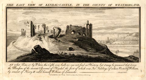 click to enlarge click to enlargeBU0222.jpg printed, top "THE EAST VIEW OF KENDAL-CASTLE, IN THE COUNTY OF WESTMORLAND." printed, bottom "AT what Time, or by Whom, this Castle was built, we can not find in History, but it may be presum'd that it was the Mansion of the ancient Barons of Kendal, the first of which was Ivo Taleboys, of whose Posterity William, by consent of Henry II. call'd himself William de Lancaster. - 1. Kendal Town. / Saml. &Nathl. Buck delin: et Sculp. Publish'd according to Act of Parliamt. March 26. 1739." item:- Armitt Library : 1959.67.22 Image © see bottom of page |
|
|
|
||
| evidence:- | descriptive text:- Simpson 1746 |
|
| source data:- | Atlas, three volumes of maps and descriptive text published as
'The Agreeable Historian, or the Compleat English Traveller
...', by Samuel Simpson, 1746. goto source goto sourcePage 1024:- "..." "... At a little Distance from the wooden Bridge [in Kendal] are the Ruins of a Castle, in which Catherine Parr, the sixth Wife of Henry VIII. was born." |
|
|
|
||
| evidence:- | old map:- Simpson 1746 map (Wmd) placename:- Kendal Castle |
|
| source data:- | Map, uncoloured engraving, Westmorland, scale about 8 miles to 1
inch, printed by R Walker, Fleet Lane, London, 1746.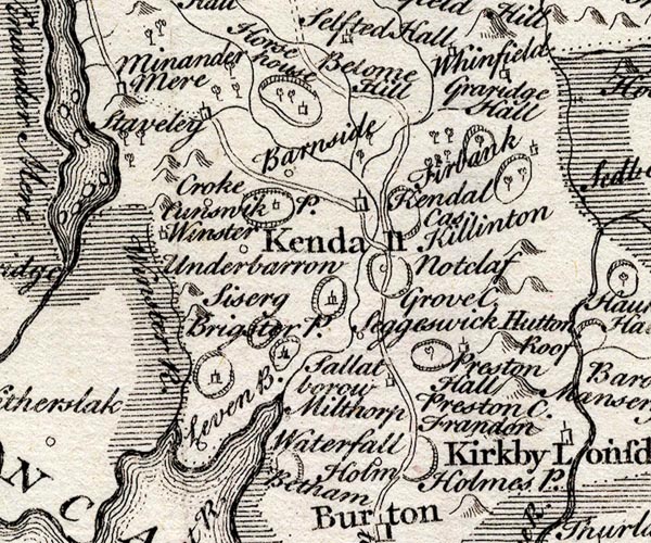 SMP2SDP.jpg "Kendal Cas." Just the park shown. item:- Dove Cottage : 2007.38.59 Image © see bottom of page |
|
|
|
||
| evidence:- | old map:- Bowen and Kitchin 1760 placename:- Kendal Castle |
|
| source data:- | Map, hand coloured engraving, A New Map of the Counties of
Cumberland and Westmoreland Divided into their Respective Wards,
scale about 4 miles to 1 inch, by Emanuel Bowen and Thomas
Kitchin et al, published by T Bowles, Robert Sayer, and John
Bowles, London, 1760.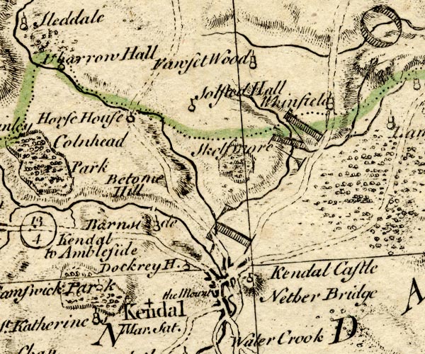 BO18SD49.jpg "Kendal Castle" circle and flag? on a hill item:- Armitt Library : 2008.14.10 Image © see bottom of page |
|
|
|
||
| evidence:- | old map:- Jefferys 1770 placename:- Castle, The |
|
| source data:- | Map, 4 sheets, The County of Westmoreland, scale 1 inch to 1
mile, surveyed 1768, and engraved and published by Thomas
Jefferys, London, 1770.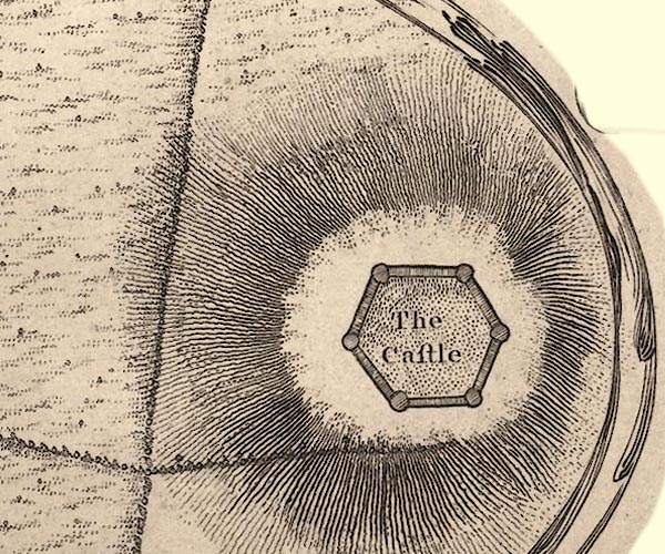 J55292C.jpg "The Castle" hexagon of walls with bastions item:- National Library of Scotland : EME.s.47 Image © National Library of Scotland |
|
|
|
||
| evidence:- | old map:- Jefferys 1770 (Wmd) |
|
| source data:- | Map, 4 sheets, The County of Westmoreland, scale 1 inch to 1
mile, surveyed 1768, and engraved and published by Thomas
Jefferys, London, 1770.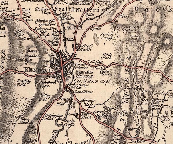 J5SD59SW.jpg "Castle" castle on a hill item:- National Library of Scotland : EME.s.47 Image © National Library of Scotland |
|
|
|
||
| evidence:- | descriptive text:- West 1778 (11th edn 1821) |
|
| source data:- | Guide book, A Guide to the Lakes, by Thomas West, published by
William Pennington, Kendal, Cumbria once Westmorland, and in
London, 1778 to 1821. goto source Page 16:- "Taillebois, baron of Kendal, is the first after the conquest who was honoured with the command of this [Lancaster] castle; and William de Taillebois in the reign of Henry II, obtained leave to take the surname of Lancaster. It is therefore probable that the barons of Kendal either built or repaired the ancient castle, in which they resided, until they erected, upon the summer site of the station of Concangium, their castle at Kendal; for the remains of some of the bastions there [Kendal] agree in style with the towers here [Lancaster]." "... ..." goto sourcePage 182:- "..." "The castle he [Mr Gray] describes thus:- 'The remains of the castle are seated on a fine hill, on the side of the river opposite to the town; almost the whole inclosure-wall remains, with four towers, two square, and two round, but their upper parts and embattlements are demolished: it is of rough stone and cement, without any ornament of arms, round, inclosing a court of the like form, and surrounded by a moat; nor ever could it have been larger than it is, for there are no traces of out-works. There is a good view of the town and river, with a fertile open valley through which it winds." "Had Mr. Gray ascended from the end of Stramongate-bridge to the castle, which was" goto sourcePage 183:- "the only way to it when in its glory, and is the easiest at present, he would have observed a square area that had been fortified with a deep moat, and connected with the castle by a draw-bridge, where was probably the base court. The stones are now entirely removed, and the ground levelled, 'and laughing Ceres reassumes the land.' The present structure was undoubtedly raised by the first Barons of Kendal, and probably on the ruins of a Roman station; this being the most eligible site in the country for a summer encampment, and at a small distance from Watercrook. There are still some remains of a dark red freestone, used in facings, and in the doors and windows, and have been brought from the environs of Penrith, more probably by the Romans, than by either the Saxon or Norman Lords. Fame says this castle held out against Oliver Cromwell, and was battered from the Castle-law-hill, but this is not so probable, as that its present ruinous state is owing to the jealousy of that usurper." goto sourceAddendum; Mr Gray's Journal, 1769 Page 213:- "..." "... I entered Kendal almost in the dark, and could distinguish only a shadow of the castle on a hill, ..." "Oct. 9. ... I went up the castle-hill: ..." goto sourcePage 214:- "... The remains of the castle are seated on a fine hill on the side of the river opposite the town; almost the whole inclosure of the walls remain, with four towers, two square and two round, but their upper parts" goto sourcePage 215:- "or embattlements are demolished; it is of rough stone and cement, without any ornament or arms, round, inclosing a court of like form, and surrounded by a moat; nor could it ever have been larger than it is, for there are no traces of out-works. There is a good view of the town and river, with a fertile open valley, though which it winds." |
|
|
|
||
| evidence:- | old map:- West 1784 map |
|
| source data:- | Map, hand coloured engraving, A Map of the Lakes in Cumberland,
Westmorland and Lancashire, scale about 3.5 miles to 1 inch,
engraved by Paas, 53 Holborn, London, about 1784.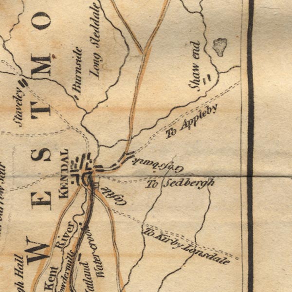 Ws02SD59.jpg On the east of Kendal. item:- Armitt Library : A1221.1 Image © see bottom of page |
|
|
|
||
| evidence:- | old text:- Camden 1789 |
|
| source data:- | Book, Britannia, or A Chorographical Description of the Flourishing Kingdoms of England,
Scotland, and Ireland, by William Camden, 1586, translated from the 1607 Latin edition
by Richard Gough, published London, 1789. goto source Page 147:- "... the Parrs, whose castle overagainst the town [Kendal] is now decaying with age. ..." |
|
|
|
||
| evidence:- | old text:- Camden 1789 (Gough Additions) |
|
| source data:- | Book, Britannia, or A Chorographical Description of the Flourishing Kingdoms of England,
Scotland, and Ireland, by William Camden, 1586, translated from the 1607 Latin edition
by Richard Gough, published London, 1789. goto source Page 151:- "..." ""... About half a mile of on the east side of the town [Kendal] is on a hill a park longing to young Mr Par, the chiefest of that name, and there is a place as it were a castle."" |
|
|
|
||
| evidence:- | old map:- Cary 1789 (edn 1805) |
|
| source data:- | Map, uncoloured engraving, Westmoreland, scale about 2.5 miles
to 1 inch, by John Cary, London, 1789; edition 1805.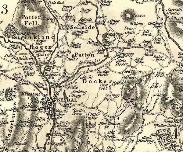 CY24SD59.jpg "Castle" house symbol; castle item:- JandMN : 129 Image © see bottom of page |
|
|
|
||
| evidence:- | descriptive text:- Baker 1802 |
|
| source data:- | Perspective road map with sections in Lancashire, Westmorland,
and Cumberland, by J Baker, London 1802. pp.25-26:- "[Kendal] ... on a hill to the right, are the ruins of the castle. ..." |
|
|
|
||
| evidence:- | old map:- Baker 1802 |
|
| source data:- | Perspective road maps with sections in Lancashire, Westmorland
and Cumberland, by J Baker, London 1802.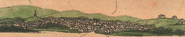 Bk03Vg13.jpg item:- private collection : 3 Image © see bottom of page |
|
|
|
||
| evidence:- | old print:- Otley 1823 (8th edn 1849) placename:- Kendal Castle |
|
| source data:- | Engraving, Ruins of Kendal Castle, drawn by T Binns, engraved by O Jewitt, on p.70
of A Descriptive Guide of the English Lakes, by Jonathan Otley, 8th edition, 1849.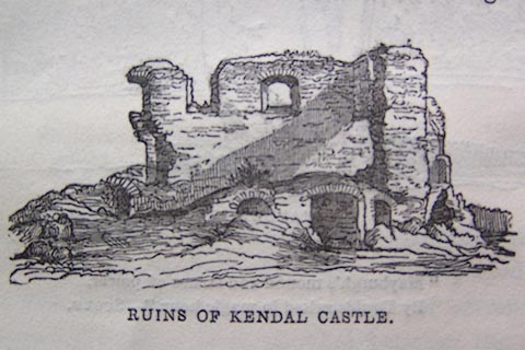 click to enlarge click to enlargeO80E22.jpg item:- Armitt Library : A1180.23 Image © see bottom of page |
|
|
|
||
| evidence:- | old print:- Otley 1823 (8th edn 1849) placename:- Kendal Castle |
|
| source data:- | Engraving, Kendal Castle - The Keep, drawn by T Binns, engraved by O Jewitt, on p.86
of A Descriptive Guide of the English Lakes, by Jonathan Otley, 8th edition, 1849.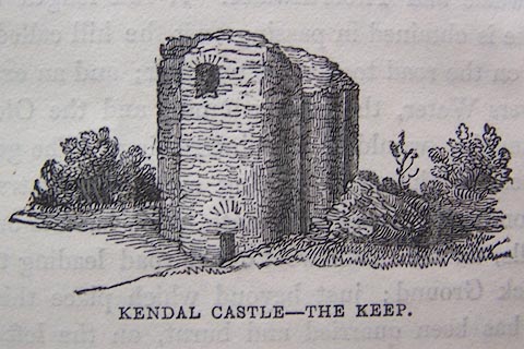 click to enlarge click to enlargeO80E24.jpg item:- Armitt Library : A1180.25 Image © see bottom of page |
|
|
|
||
| evidence:- | descriptive text:- Ford 1839 (3rd edn 1843) |
|
| source data:- | Guide book, A Description of Scenery in the Lake District, by
Rev William Ford, published by Charles Thurnam, Carlisle, by W
Edwards, 12 Ave Maria Lane, Charles Tilt, Fleet Street, William
Smith, 113 Fleet Street, London, by Currie and Bowman,
Newcastle, by Bancks and Co, Manchester, by Oliver and Boyd,
Edinburgh, and by Sinclair, Dumfries, 1839. goto source "... The Norman conquerors, however, seem to have left this tract [The Lakes] wholly to itself: all the remains of the castles being found on the outskirts, as Egremont, Cockermouth, Brougham, and Kendal. ..." goto sourcePage 20:- "... [Kendal]" "The chief objects of interest are the castle, of which four broken towers and part of the outer wall still remain. In 1813, the foundations were strengthened and skirted with a thriving plantation, enriching the view from the town. This fortress, the seat of the Barons of Kendal, and birth-place of Catherine Parr, stands on the east side of the Kent, upon a hill composed of rounded stones, embedded in a black sandy cement. It is well worth visiting, both from the beauty of its commanding situation, and from the interest always excited by the venerable relics of former days. ..." |
|
|
|
||
| evidence:- | old photograph:- Bell 1880s-1940s placename:- Kendal Castle |
|
| source data:- | Photograph, Kendal Castle, Kendal, Westmorland, by Herbert Bell, photographer, Ambleside,
Westmorland, 1894. click to enlarge click to enlargeHB0157.jpg Vol.2 no.157 in an album, Examples of Early Domestic and Military Architecture in Westmorland, assembled 1910. ms at bottom:- "157. Kendal Castle. Kendal. K." item:- Armitt Library : 1958.3166.51 Image © see bottom of page |
|
|
|
||
| evidence:- | old photograph:- Bell 1880s-1940s placename:- Kendal Castle |
|
| source data:- | Photograph, Kendal Castle, the Round Tower, Kendal, Westmorland, by Herbert Bell,
photographer, Ambleside, Westmorland, 1894. click to enlarge click to enlargeHB0158.jpg Vol.2 no.158 in an album, Examples of Early Domestic and Military Architecture in Westmorland, assembled 1910. ms at bottom:- "158. Kendal Castle. The Round Tower. Kendal. K." item:- Armitt Library : 1958.3166.52 Image © see bottom of page |
|
|
|
||
| evidence:- | old text:- Harper 1907 |
|
| source data:- | HP01p100.txt Page 100:- "..." "Now Kendal is approached, its ruined castle surmounting a rounded green hill and thrusting out ragged walls almost in the likeness of some rocky outcrop. Kendal Castle seems to have been so threatening a fortress - and it still looks especially formidable from the north, whence most of its possible enemies could come - that no one appears ever to have attacked it. They went round the other way, if another way could be found, or - better still - stopped at home." "..." "At Kendal was born much-married Katherine Parr, whose family at the time were lords of the castle. Thirdly, she was married by Henry the Eighth, and was so fortunate as to survive him. How little she regretted that Royal husband we may judge from the fact that, two months after his death she married, fourthly an old flame, Admiral Lord Seymour of Sudeley, and then, a year later, died, aged thirty-six." "..." HP01p102.txt Page 102:- "..." 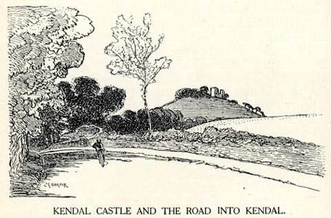 click to enlarge click to enlargeHP0106.jpg "KENDAL CASTLE AND THE ROAD INTO KENDAL." item:- JandMN : 1055.7 Image © see bottom of page |
|
|
|
||
| evidence:- | site plan:- Curwen 1913 placename:- Kendal Castle |
|
| source data:- | Site plan, lithograph, Kendal Castle, with suggested plan of gatehouse, Kendal, Westmorland,
published for the Cumberland and Westmorland Antiquarian and Archaeological Society
by Titus Wilson, Kendal, Westmorland, 1913.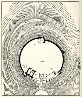 click to enlarge click to enlargeCW0126.jpg On p.146 of The Castles and Fortified Towers of Cumberland, Westmorland, and Lancashire North of the Sands, by John F Curwen. printed at bottom:- "KENDAL CASTLE, / ..." item:- Armitt Library : A782.26 Image © see bottom of page |
|
|
|
||
| evidence:- | old print:- Curwen 1913 placename:- Kendal Castle |
|
| source data:- | Print, halftone photograph, Kendal Castle, mural turret etc, Kendal, Westmorland,
published for the Cumberland and Westmorland Antiquarian and Archaeological Society
by Titus Wilson, Kendal, Westmorland, 1913.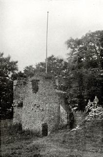 click to enlarge click to enlargeCW0127.jpg Tipped in opposite p.148 of The Castles and Fortified Towers of Cumberland, Westmorland, and Lancashire North of the Sands, by John F Curwen. printed at bottom:- "KENDAL CASTLE. / ..." item:- Armitt Library : A782.27 Image © see bottom of page |
|
|
|
||
| evidence:- | old print:- Curwen 1913 placename:- Kendal Castle |
|
| source data:- | Print, halftone photograph, Kendal Castle, entrenchment and rampart, Kendal, Westmorland,
published for the Cumberland and Westmorland Antiquarian and Archaeological Society
by Titus Wilson, Kendal, Westmorland, 1913.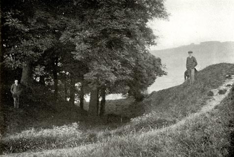 click to enlarge click to enlargeCW0128.jpg Tipped in opposite p.149 of The Castles and Fortified Towers of Cumberland, Westmorland, and Lancashire North of the Sands, by John F Curwen. printed at bottom:- "KENDAL CASTLE. / ..." item:- Armitt Library : A782.28 Image © see bottom of page |
|
|
|
||
| evidence:- | site plan:- Historical Monuments 1936 placename:- Kendal Castle item:- |
|
| source data:- | Site plan, uncoloured lithograph, Kendal Castle, Kendal, Westmorland, scale about
1 to 580, published by Royal Commission on Historical Monuments England, London, 1936.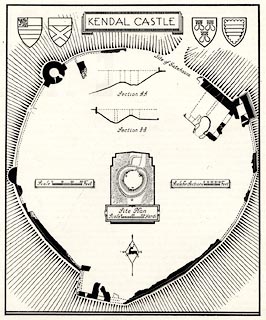 click to enlarge click to enlargeHMW077.jpg On p.123 of the Inventory of the Historical Monuments in Westmorland. printed, top "KENDAL CASTLE" RCHME no. Wmd, Kendal 3 item:- Armitt Library : A745.77 Image © see bottom of page |
|
|
|
||
| evidence:- | old print:- Bogg 1898 placename:- Kendal Castle |
|
| source data:- | Print, engraving, Ruins of Kendal Castle, Kendal, Westmorland, by A Haselgrave, published
by Edmund Bogg, 3 Woodhouse Lane, and James Miles, Guildford Street, Leeds, Yorkshire,
1898.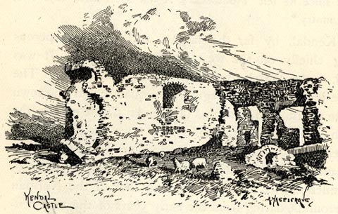 click to enlarge click to enlargeBGG151.jpg Included on p.226 of Lakeland and Ribblesdale, by Edmund Bogg. item:- JandMN : 231.51 Image © see bottom of page |
|
|
|
||
| evidence:- | old print:- Sylvan 1847 placename:- Kendal Castle |
|
| source data:- | Print, engraving, Ruined Tower, Kendal Castle, Westmorland, published by John Johnstone,
Paternoster Row, London, et al, 1847.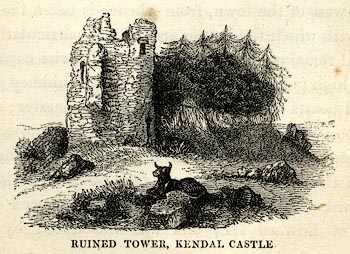 click to enlarge click to enlargeSYL105.jpg On p.20 of Sylvan's Pictorial Guide to the English Lakes. item:- Armitt Library : A1201.5 Image © see bottom of page |
|
|
|
||
| evidence:- | old print:- Rose 1832-35 (vol.1 no.22) |
|
| source data:- | Print, uncoloured engraving, Kendal, from the Castle, Westmorland, drawn by Thomas
Allom, engraved by W le Petit, published by Fisher, Son and Co, London, 1832-35.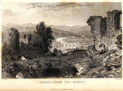 click to enlarge click to enlargePR0008.jpg vol.1 pl.22 in the set of prints, Westmorland, Cumberland, Durham and Northumberland Illustrated. printed at bottom left, right, centre:- "T. Allom. / W. Le Petit. / KENDAL, FROM THE CASTLE. / FISHER, SON &CO. LONDON, 1832." item:- Dove Cottage : 2008.107.8 Image © see bottom of page |
|
|
|
||
| evidence:- | old print:- |
|
| source data:- | Print, uncoloured engraving, Kendal Castle, published by Hudson and Nicholson, Kendal,
Westmorland, 1832.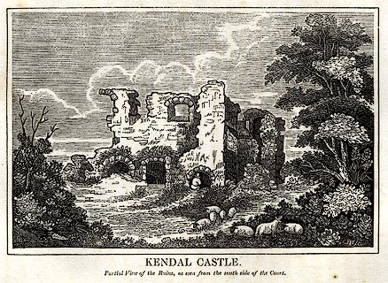 click to enlarge click to enlargePR0738.jpg Tipped in opposite p.70 of The Annals of Kendal by Cornelius Nicholson. item:- private collection : 125.11 Image © see bottom of page |
|
|
|
||
| evidence:- | old print:- placename:- Kendal Castle |
|
| source data:- | Print, engraving, View of Kendal Castle, in Westmorland, engraved by Lowry, published
by Alexander Hogg, 16 Paternoster Row, London, 1780s?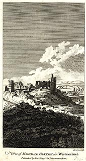 click to enlarge click to enlargePR0417.jpg printed at bottom right, centre:- "Lowry sculp. / View of KENDAL CASTLE in Westmorland. / Published by Alexr. Hogg No.16 Paternoster Row." item:- Dove Cottage : 2008.107.410 Image © see bottom of page |
|
|
|
||
| evidence:- | old print:- Dodsley 1764 placename:- Kendal Castle |
|
| source data:- | Print, engraving, Kendal Castle, Kendal, Westmorland, drawn by B
Ralph, engraved by J Ryland, published by R and J Dodsley, Pall
Mall, London, 1763-64.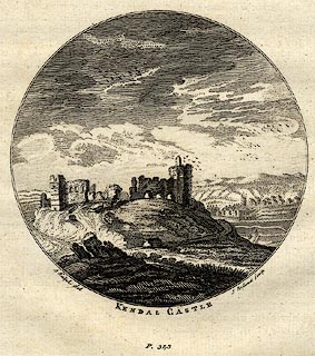 click to enlarge click to enlargeDOD1E2.jpg "... KENDAL CASTLE ..." item:- JandMN : 120.3 Image © see bottom of page |
|
|
|
||
 BJX11.jpg (taken 3.10.2005) 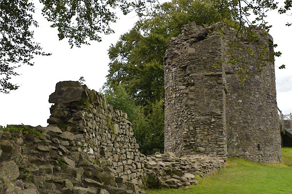 CGJ97.jpg (taken 20.8.2017) 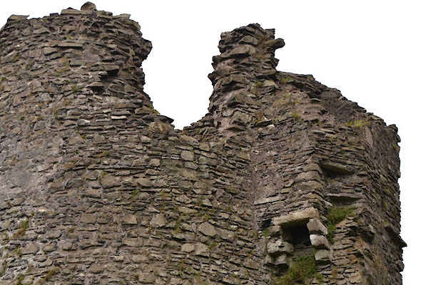 CGJ98.jpg (taken 20.8.2017) 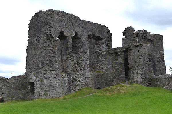 CGJ99.jpg (taken 20.8.2017) 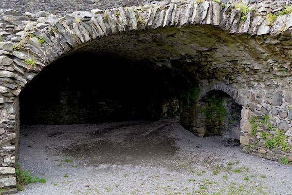 CGK01.jpg (taken 20.8.2017) |
||
|
|
||
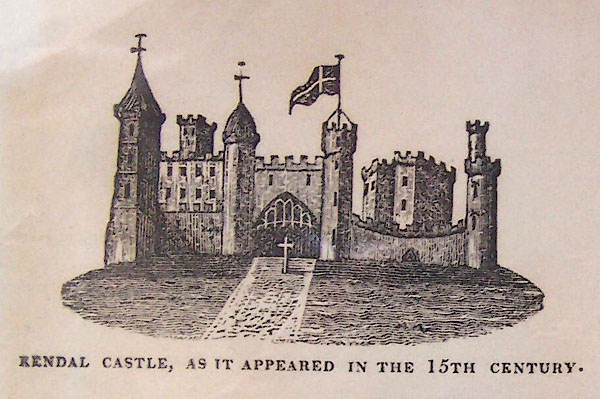 BMD07.jpg 'As it was' in the 15th century. 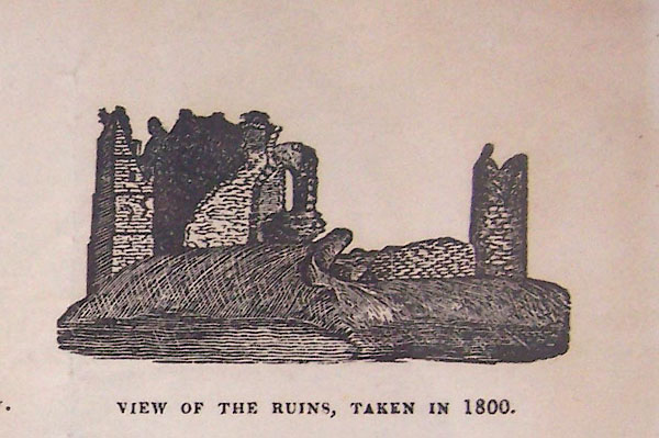 BMD08.jpg 'As it is' 1800. |
||
|
|
||
| hearsay:- |
Built by William Rufus, 13th century. It was owned by Thomas Parr father of Katherine
Parr, who was probably not born here but lived here as a child. When Katherine's brother
died without an heir, 1571, the castle was abandoned. |
|
|
|
||
| notes:- |
13th century castle, with tower, hall, gatehouse etc |
|
| Perriam, D R &Robinson, J: 1998: Medieval Fortified Buildings of Cumbria: CWAAS::
ISBN 1 873124 23 6; plans and illustrations |
||
|
|
||
| personal | ||
| person:- | : Parr, Catherine |
|
| place:- | birthplace (wrong) | |
|
|
||
Lakes Guides menu.