 Old Cumbria Gazetteer
 |
 |
|
| Kingsdale, North Yorkshire | ||
| Kingsdale | ||
| site name:- | Kingsdale Beck | |
| county:- | North Yorkshire | |
| locality type:- | valley | |
| 1Km square:- | SD6976 (etc) | |
| 10Km square:- | SD67 | |
| 10Km square:- | SD77 | |
|
|
||
| evidence:- | descriptive text:- West 1778 (11th edn 1821) placename:- Kingsdale |
|
| source data:- | Guide book, A Guide to the Lakes, by Thomas West, published by
William Pennington, Kendal, Cumbria once Westmorland, and in
London, 1778 to 1821. goto source goto sourceTour to the Caves in the West Riding of Yorkshire, late 18th century Page 245:- "... Yordas-Cave, in the vale of Kingsdale, ... a fine cascade, called Thornton-force, near some slate quarries, made by the river issuing out of Kingsdale. ... ... We now found ourselves in the midst of a small valley, about three miles long, and somewhat more than half a mile broad, the most extraordinary of any we had yet seen. It was surrounded on all sides by" goto sourcePage 246:- "high mountains, some of them the loftiest of any in England - Whernside to the south-east, and Gragareth to the north. There was no descent from this vale, except the deep chasm where we saw the cascade. It seemed opened in some distant age, either by the gradual effect of the washing of the river, or some violent and extraordinary flood bursting open the rugged barrier that pent it up. The vale above has all the appearance of having been once a lake, from the flatness of its surface, and its rich soil, like a sediment subsided on the bottom of a stagnant water. We were informed, that the subterranean cascade beneath, just now mentioned, has but lately made its appearance, and is every day more and more enlarging. We were quite secluded from the world, not an habitation for a man in view, but a lonely shepherd's house, with a little wood, and a few inclosures near it, called Breadagarth: ... The soil seemed the deepest and richest, in some parts of this vale, of any we had ever observed, and no doubt is capable of great improvement. We could not but lament, that instead of peopling the wilds and deserts of North America, our fellow-subjects had not peopled the fertile wastes of the north of England. We have since indeed been informed, that a plan is in agitation for having them inclosed, when no doubt but it will support some scores of additional families.- ..." |
|
|
|
||
| evidence:- | old map:- Balderston c1890 map placename:- King's Dale |
|
| source data:- | Map, the hills in the Ingleton area, probably by Robert R
Balderston, engraved by Goodall and Suddick, Leeds, West
Yorkshire, about 1890.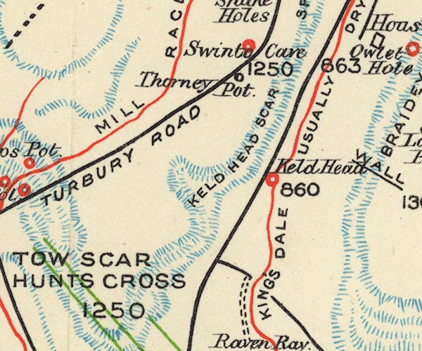 BS1SD67Y.jpg "KING'S DALE USUALLY DRY" item:- private collection : 27.1 Image © see bottom of page |
|
|
|
||
Lakes Guides menu.