 Old Cumbria Gazetteer
 |
 |
|
| Kirkandrews | ||
| Kirkandrews on Esk | ||
| civil parish:- | Kirkandrews (formerly Cumberland) | |
| county:- | Cumbria | |
| locality type:- | locality | |
| 1Km square:- | NY3569 (etc) | |
| 10Km square:- | NY36 | |
| 10Km square:- | NY37 | |
|
|
||
| evidence:- | old map:- Saxton 1579 placename:- Kirkanders |
|
| source data:- | Map, hand coloured engraving, Westmorlandiae et Cumberlandiae Comitatus ie Westmorland
and Cumberland, scale about 5 miles to 1 inch, by Christopher Saxton, London, engraved
by Augustinus Ryther, 1576, published 1579-1645.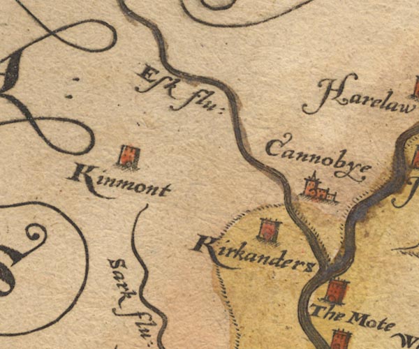 Sax9NY37.jpg Tower, symbol for a house, hall, tower, etc. "Kirkanders" item:- private collection : 2 Image © see bottom of page |
|
|
|
||
| evidence:- | old map:- Mercator 1595 (edn?) placename:- Kirk Andros |
|
| source data:- | Map, hand coloured engraving, Northumbria, Cumberlandia, et
Dunelmensis Episcopatus, ie Northumberland, Cumberland and
Durham etc, scale about 6.5 miles to 1 inch, by Gerard Mercator,
Duisberg, Germany, about 1595.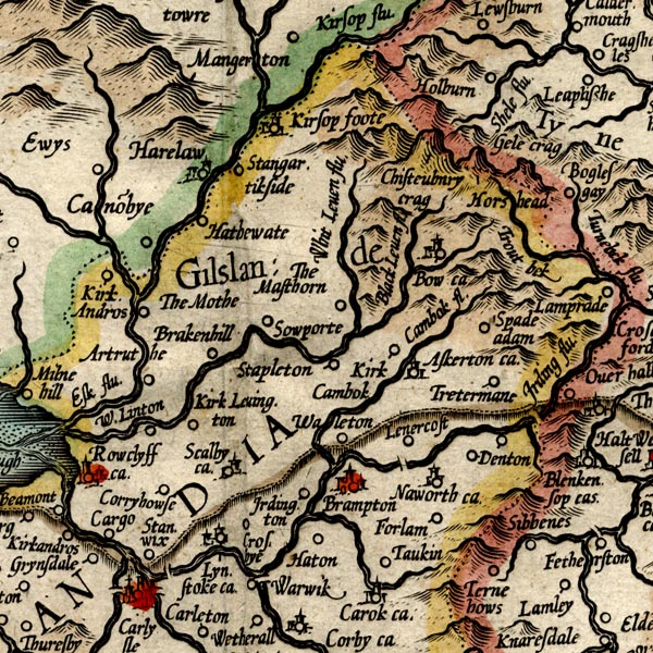 MER8CumA.jpg "Kirk Andros" circle item:- JandMN : 169 Image © see bottom of page |
|
|
|
||
| evidence:- | old map:- Speed 1611 (Cmd) placename:- Kirkanders |
|
| source data:- | Map, hand coloured engraving, Cumberland and the Ancient Citie
Carlile Described, scale about 4 miles to 1 inch, by John Speed,
1610, published by J Sudbury and George Humble, Popes Head
Alley, London, 1611-12.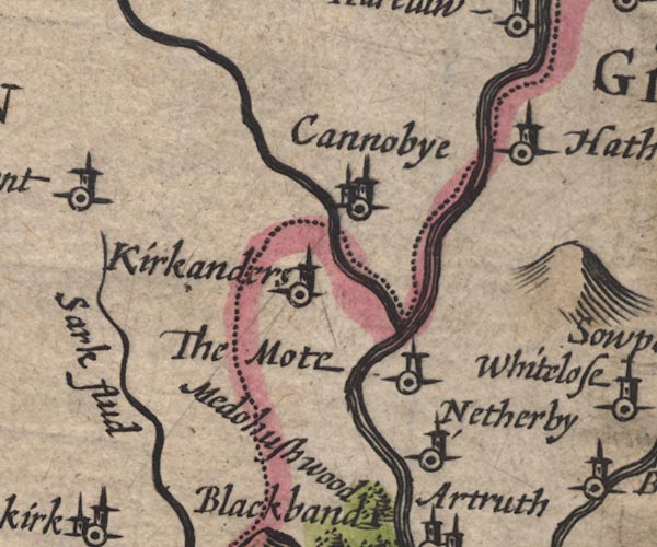 SP11NY37.jpg "Kirkanders" circle, tower item:- private collection : 16 Image © see bottom of page |
|
|
|
||
| evidence:- | old map:- Jansson 1646 placename:- Kirkanders |
|
| source data:- | Map, hand coloured engraving, Cumbria and Westmoria, ie
Cumberland and Westmorland, scale about 3.5 miles to 1 inch, by
John Jansson, Amsterdam, Netherlands, 1646.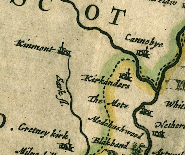 JAN3NY37.jpg "Kirkanders" Buildings and tower. item:- JandMN : 88 Image © see bottom of page |
|
|
|
||
| evidence:- | old map:- Morden 1695 (Cmd) placename:- Kirkanders |
|
| source data:- | Map, uncoloured engraving, Cumberland, scale about 4 miles to 1
inch, by Robert Morden, 1695, published by Abel Swale, the
Unicorn, St Paul's Churchyard, Awnsham, and John Churchill, the
Black Swan, Paternoster Row, London, 1695-1715.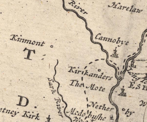 MD12NY37.jpg "Kirkanders" Circle. item:- JandMN : 90 Image © see bottom of page |
|
|
|
||
| evidence:- | old map:- Bowen and Kitchin 1760 placename:- Kirkander placename:- Upper Kirkander placename:- Middle Kirkander placename:- Nether Kirkander |
|
| source data:- | Map, hand coloured engraving, A New Map of the Counties of
Cumberland and Westmoreland Divided into their Respective Wards,
scale about 4 miles to 1 inch, by Emanuel Bowen and Thomas
Kitchin et al, published by T Bowles, Robert Sayer, and John
Bowles, London, 1760.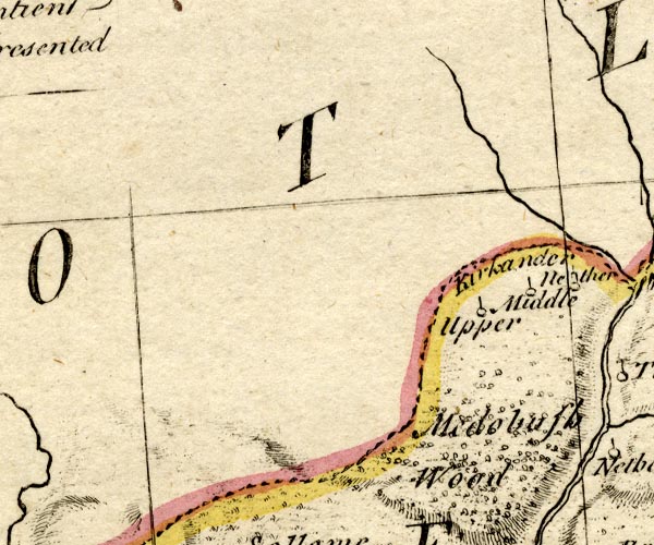 BO18NY37.jpg "Kirkander / Upper" circle and line "Kirkander / Middle" circle and line 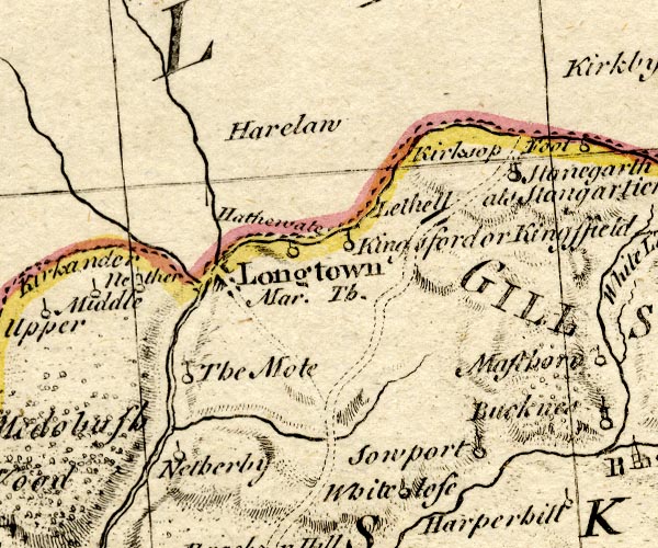 BO18NY47.jpg "Kirkander / Nether" circle, tower item:- Armitt Library : 2008.14.10 Image © see bottom of page |
|
|
|
||
| evidence:- | road book:- Cary 1798 (2nd edn 1802) placename:- Kirkandrews |
|
| source data:- | Road book, itineraries, Cary's New Itinerary, by John Cary, 181
Strand, London, 2nd edn 1802. goto source goto source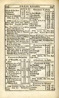 click to enlarge click to enlargeC38555.jpg page 555-556 "to Kirkandrews" item:- JandMN : 228.2 Image © see bottom of page |
|
|
|
||
| evidence:- | old map:- Cooke 1802 placename:- Kirkandrews |
|
| source data:- | Map, Cumberland, scale about 15.5 miles to 1 inch, by George
Cooke, 1802, bound in Gray's New Book of Roads, 1824, published
by Sherwood, Jones and Co, Paternoster Road, London, 1824. click to enlarge click to enlargeGRA1Cd.jpg "Kirkandrews" blocks, italic lowercase text, village, hamlet, locality item:- Hampshire Museums : FA2000.62.2 Image © see bottom of page |
|
|
|
||
| evidence:- | old map:- Cooper 1808 placename:- Kirkandrews |
|
| source data:- | Map, uncoloured engraving, Cumberland, scale about 10.5 miles to
1 inch, drawn and engraved by Cooper, published by R Phillips,
Bridge Street, Blackfriars, London, 1808. click to enlarge click to enlargeCOP3.jpg "Kirkandrews" circle; village or hamlet item:- JandMN : 86 Image © see bottom of page |
|
|
|
||
| evidence:- | old map:- Wallis 1810 (Cmd) placename:- Kirkandrews |
|
| source data:- | Road map, hand coloured engraving, Cumberland, scale about 16
miles to 1 inch, by James Wallis, 77 Berwick Stree, Soho,
London, 1810. click to enlarge click to enlargeWL13.jpg "Kirkandrews" village, hamlet, house, ... item:- Dove Cottage : 2009.81.10 Image © see bottom of page |
|
|
|
||
| evidence:- | old map:- Hall 1820 (Cmd) placename:- Kirkandrews |
|
| source data:- | Map, hand coloured engraving, Cumberland, scale about 21 miles
to 1 inch, engraved by Sidney Hall, published by S Leigh, 18
Strand, London, 1820-31. click to enlarge click to enlargeHA14.jpg "Kirkandrews" circle, italic lowercase text; settlement item:- JandMN : 91 Image © see bottom of page |
|
|
|
||
| evidence:- | old map:- Ford 1839 map placename:- Kirkandrews |
|
| source data:- | Map, uncoloured engraving, Map of the Lake District of
Cumberland, Westmoreland and Lancashire, scale about 3.5 miles
to 1 inch, published by Charles Thurnam, Carlisle, and by R
Groombridge, 5 Paternoster Row, London, 3rd edn 1843. FD02NY37.jpg "Kirkandrews" item:- JandMN : 100.1 Image © see bottom of page |
|
|
|
||
| evidence:- | old map:- Garnett 1850s-60s H placename:- Kirkandrews |
|
| source data:- | Map of the English Lakes, in Cumberland, Westmorland and
Lancashire, scale about 3.5 miles to 1 inch, published by John
Garnett, Windermere, Westmorland, 1850s-60s. GAR2NY35.jpg "Kirkandrews" blocks, settlement item:- JandMN : 82.1 Image © see bottom of page |
|
|
|
||
| evidence:- | old print:- item:- Last House in England |
|
| source data:- | Print, The Last House in England, Near Gretna Green, Kirkandrews, Cumberland, drawn
by William Henry Nutter, engraved by G C Thurnam, 1850s.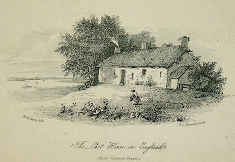 click to enlarge click to enlargePR1034.jpg View of a small thatched cottage standing on a hillock beside a river or estuary which lies to left of composition. A bank of flowers lies in the foreground. An elderly woman walks along the path leading to the cottage door; a child stands in the doorway watching her approach. Which 'last house' rather depends on yoour route; if it is the old route to Sark Bridge this could be Guards Cottage? inscribed at bottom left on print:- "W.H.Nutter, Delt." printed at bottom centre:- "The Last House in England. [near Gretna Green]" inscribed at bottom right on print:- "G.C. Thurnham, Sculpt." item:- Tullie House Museum : 1970.33.15 Image © Tullie House Museum |
|
|
|
||
Lakes Guides menu.