 Old Cumbria Gazetteer
 |
 |
|
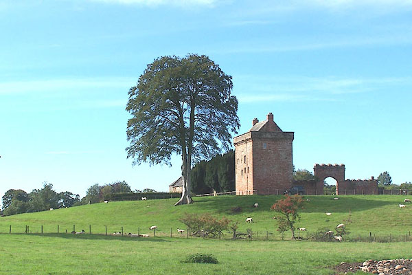
| Kirkandrews Tower, Kirkandrews | ||
| Kirkandrews Tower | ||
| Kirkandrews on Esk Tower | ||
| civil parish:- | Kirkandrews (formerly Cumberland) | |
| county:- | Cumbria | |
| locality type:- | buildings | |
| coordinates:- | NY38877190 | |
| 1Km square:- | NY3871 | |
| 10Km square:- | NY37 | |
|
|
||
 BMQ42.jpg (taken 15.9.2006) 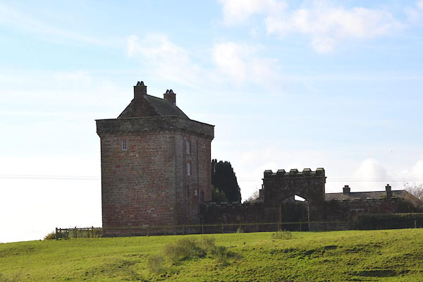 CGT15.jpg (taken 20.10.2017) |
||
|
|
||
| evidence:- | old map:- Burghley 1590 (facsimile) placename:- Kyrkander |
|
| source data:- | Facsimile map, A Platt of the Opposete Border of Scotland to ye West Marches of England,
parts of Cumberland and Scotland including the Debateable Land, from a manuscript
drawn for William Cecil, Lord Burghley, about 1590, published by R B Armstrong, 1897. courtesy of the National Library of Scotland 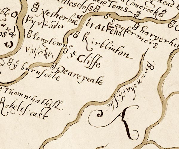 M048NY46.jpg "Kyrka~der" circle item:- National Library of Scotland : MS6113 f.267 Image © National Library of Scotland |
|
|
|
||
| evidence:- | probably descriptive text:- Simpson 1746 placename:- Kirkanders |
|
| source data:- | Atlas, three volumes of maps and descriptive text published as
'The Agreeable Historian, or the Compleat English Traveller
...', by Samuel Simpson, 1746. goto source goto source"... Kirkanders, upon the Eske, the late Lord Preston's. ..." |
|
|
|
||
| evidence:- | old map:- Donald 1774 (Cmd) placename:- Kirkandrews |
|
| source data:- | Map, hand coloured engraving, 3x2 sheets, The County of Cumberland, scale about 1
inch to 1 mile, by Thomas Donald, engraved and published by Joseph Hodskinson, 29
Arundel Street, Strand, London, 1774.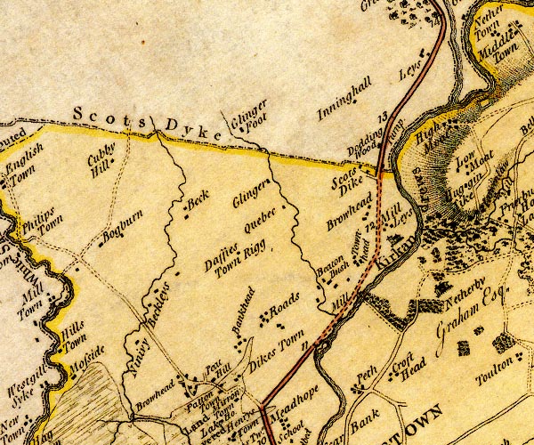 D4NY37SE.jpg "Kirkandrews" house item:- Carlisle Library : Map 2 Image © Carlisle Library |
|
|
|
||
| evidence:- | old text:- Camden 1789 (Gough Additions) |
|
| source data:- | Book, Britannia, or A Chorographical Description of the Flourishing Kingdoms of England,
Scotland, and Ireland, by William Camden, 1586, translated from the 1607 Latin edition
by Richard Gough, published London, 1789. goto source Page 195:- "..." "... The antient border house at Kirk Andrews, opposite to Netherby, is a square tower of three stones, the windows small, the door of iron: the cattle lodged below, the owners above." |
|
|
|
||
| evidence:- | site plan:- Curwen 1913 placename:- Kirkandrews Tower |
|
| source data:- | Site plan, lithograph, Kirkandrews on Esk, Kirkandrews Tower, Kirkandrews, Cumberland,
published for the Cumberland and Westmorland Antiquarian and Archaeological Society
by Titus Wilson, Kendal, Westmorland, 1913.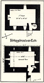 click to enlarge click to enlargeCW0178.jpg On p.380 of The Castles and Fortified Towers of Cumberland, Westmorland, and Lancashire North of the Sands, by John F Curwen. printed at centre:- "Kirkandrews-on-Esk:" item:- Armitt Library : A782.78 Image © see bottom of page |
|
|
|
||
| evidence:- | database:- Listed Buildings 2010 placename:- Kirkandrews Tower |
|
| source data:- | courtesy of English Heritage "KIRKANDREWS TOWER / / / KIRKANDREWS / CARLISLE / CUMBRIA / II[star] / 78154 / NY3891471928" |
|
|
|
||
| evidence:- | database:- Listed Buildings 2010 item:- date stone (1827) |
|
| source data:- | courtesy of English Heritage "SCREEN WALLS ADJOINING KIRKANDREWS TOWER / / / KIRKANDREWS / CARLISLE / CUMBRIA / II / 78155 / NY3890271918" |
|
|
|
||
| evidence:- | database:- Listed Buildings 2010 |
|
| source data:- | courtesy of English Heritage "FARMHOUSE AND BARN ADJOINING WALL TO WEST OF KIRKANDREWS TOWER / / / KIRKANDREWS / CARLISLE / CUMBRIA / II / 78156 / NY3886271898" |
|
|
|
||
| evidence:- | possibly (misplaced) old print:- Rose 1832-35 |
|
| source data:- | Print, engraving, Netherby, Cumberland, by Thomas Allom, engraved by J C Bentley,
1833.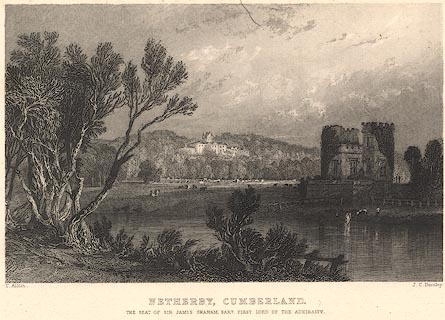 click to enlarge click to enlargeR223.jpg "Netherby, Cumberland" item:- JandMN : 96.12 Image © see bottom of page |
|
|
|
||
| hearsay:- |
16th century pele. Closed to visits. |
|
|
|
||
| notes:- |
tower |
|
| Perriam, D R &Robinson, J: 1998: Medieval Fortified Buildings of Cumbria: CWAAS::
ISBN 1 873124 23 6; plan and elevation |
||
|
|
||
Lakes Guides menu.