 Old Cumbria Gazetteer
 |
 |
|
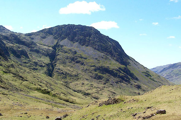
| Lingmell, Nether Wasdale | ||
| Lingmell | ||
| locality:- | Sca Fell | |
| civil parish:- | Nether Wasdale (formerly Cumberland) | |
| county:- | Cumbria | |
| locality type:- | hill | |
| coordinates:- | NY20930818 | |
| 1Km square:- | NY2008 | |
| 10Km square:- | NY20 | |
| altitude:- | 2123 feet | |
| altitude:- | 647m | |
|
|
||
 BQO19.jpg (taken 12.5.2009) |
||
|
|
||
| evidence:- | old print:- Green 1814 (plate 44) |
|
| source data:- | Print, uncoloured soft ground etching, Wast Water from the Road, Nether Wasdale, Cumberland,
by William Green, Ambleside, Westmorland, 1814.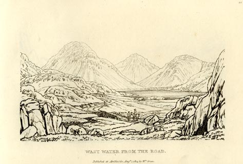 click to enlarge click to enlargeGN0944.jpg Plate 44 in Sixty Small Prints. printed at top right:- "44" printed at bottom:- "WAST WATER FROM THE ROAD. / Published at Ambleside Augst. 1, 1814, by Wm. Green." item:- Armitt Library : A6656.44 Image © see bottom of page |
|
|
|
||
| evidence:- | old print:- Green 1814 (plate 44) |
|
| source data:- | Print, tinted soft ground etching, Wast Water from the Road, Nether Wasdale, Cumberland,
by William Green, Ambleside, Westmorland, 1814.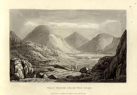 click to enlarge click to enlargeGN1044.jpg Plate 44 in Sixty Small Prints. printed at top right:- "44" printed at bottom:- "WAST WATER FROM THE ROAD. / Published at Ambleside Augst. 1, 1814, by Wm. Green." item:- Armitt Library : A6653.44 Image © see bottom of page |
|
|
|
||
| evidence:- | outline view:- Otley 1823 (4th edn 1830) placename:- Lingmell |
|
| source data:- | Print, engraving, outline view, Mountains round Wastwater as seen from the Strands
in Nether Wasdale, published by Jonathan Otley, Keswick, Cumberland et al, 1830.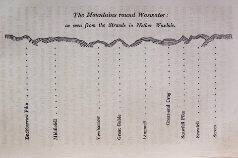 click to enlarge click to enlargeO75E08.jpg p.129 in A Concise Description of the English Lakes, by Jonathan Otley, 4th edition, 1830. "The Mountains round Wastwater: / as seen from the Strands in Nether Wasdale." "Buckbarrow Pike / Middlefell / Yewbarrow / Great Gable / Lingmell / Great-end Crag / Scawfell Pike / Scawfell / Screes" item:- Armitt Library : A1175.8 Image © see bottom of page |
|
|
|
||
| evidence:- | outline view:- Otley 1823 (8th edn 1849) placename:- Lingmell placename:- Lingmel |
|
| source data:- | Engraving, outline view of mountains, Mountains of Wast Water as seen from Nether
Wasdale, drawn by T Binns, engraved by O Jewitt, opposite p.22 of A Descriptive Guide
of the English Lakes, by Jonathan Otley, 8th edition, 1849.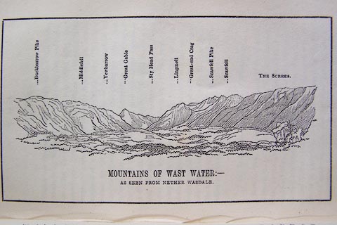 click to enlarge click to enlargeO80E13.jpg item:- Armitt Library : A1180.14 Image © see bottom of page |
|
|
|
||
| evidence:- | outline view:- Otley 1823 (8th edn 1849) placename:- Lingmell placename:- Lingmel |
|
| source data:- | Engraving, outline view of mountains, A Group of Mountains seen from Helvellyn, looking
towards the South West, drawn by T Binns, engraved by O Jewitt, opposite p.50 of A
Descriptive Guide of the English Lakes, by Jonathan Otley, 8th edition, 1849.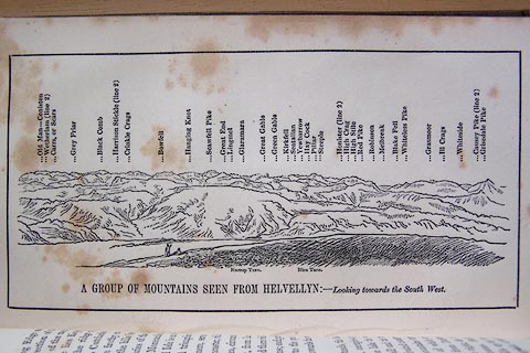 click to enlarge click to enlargeO80E17.jpg item:- Armitt Library : A1180.18 Image © see bottom of page |
|
|
|
||
| evidence:- | outline view:- Otley 1823 (5th edn 1834) |
|
| source data:- | Print, woodcut outline view, Mountains of Wast Water, by
Jonathan Otley, Keswick, Cumberland, 1830.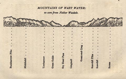 click to enlarge click to enlargeOT2E07.jpg Printed on p.31 of A Concise Description of the English Lakes, by Jonathan Otley, 5th edition, 1834. "THE MOUNTAINS OF WAST WATER: as seen from Nether Wasdale." "Buckbarrow Pike / Middlefell / Yewbarrow / Great Gable / Sty Head Pass / Lingmell / Great-end Crag / Scawfell Pike / Scawfell / Screes" item:- JandMN : 48.8 Image © see bottom of page |
|
|
|
||
| evidence:- | old text:- Martineau 1855 |
|
| source data:- | Guide book, A Complete Guide to the English Lakes, by Harriet
Martineau, published by John Garnett, Windermere, Westmorland,
and by Whittaker and Co, London, 1855; published 1855-76. goto source goto sourcePage 157:- "... There are four summits which collectively go under the name of Scawfell; viz, the most southerly, which is called simply Scawfell; Scawfell Pike, which is sixty feet higher, and the highest mountain in England (3,160 feet:) and the lower hills, Lingmell and Great End,- the last being the northernmost, and fronting Borrowdale. ..." |
|
|
|
||
| evidence:- | old photograph:- Bell 1880s-1940s item:- boat; rowing boat |
|
| source data:- | Photograph, black and white, Lingmell, Nether Wasdale and Scafell Pike, Eskdale, Cumberland,
by Herbert Bell, photographer, Ambleside, Westmorland, 1890s.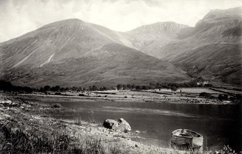 click to enlarge click to enlargeHB0883.jpg internegative at lower left:- "H. Bell" item:- Armitt Library : ALPS554 Image © see bottom of page |
|
|
|
||
| evidence:- | old photograph:- Bell 1880s-1940s |
|
| source data:- | Photograph, sepia, Lingmell from Sty Head, Nether Wasdale, Cumberland, by Herbert
Bell, photographer, Ambleside, Westmorland, 1890s.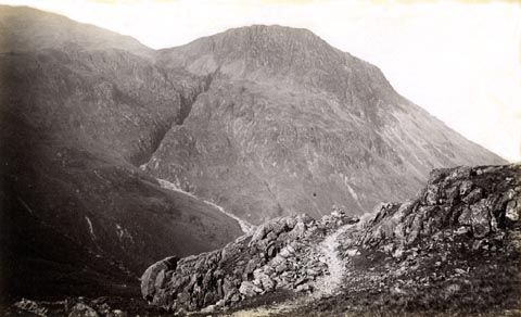 click to enlarge click to enlargeHB0650.jpg internegative at lower left:- "H. Bell." item:- Armitt Library : ALPS313 Image © see bottom of page |
|
|
|
||
| evidence:- | outline view:- Seascale 1920s-30s placename:- Lingmell |
|
| source data:- | Print, uncoloured engraving, outline view, mountains from Seascale, published by Edward
Burrow and Son, Cheltenham, Gloucestershire, 1920s-30s.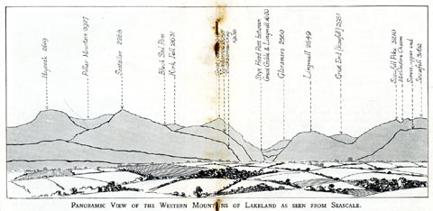 click to enlarge click to enlargeSES113.jpg "PANORAMIC VIEW OF THE WESTERN MOUNTAINS OF LAKELAND AS SEEN FROM SEASCALE." "... Lingmell 2649 ..." item:- JandMN : 1079.13 Image © see bottom of page |
|
|
|
||
| evidence:- | outline view:- Jenkinson 1875 placename:- Lingmell |
|
| source data:- | Print, lithograph, outline view, Panoramic Sketches from Helvellyn, Westmorland, by
Edwin A Pettitt, London, published by Edward Stanford, 55 Charing Cross, London, 1875.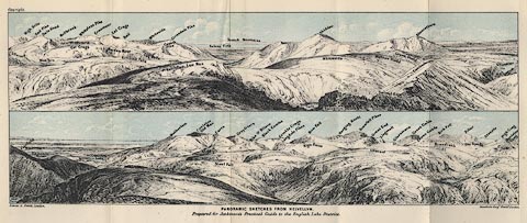 click to enlarge click to enlargeJk01E1.jpg "... Lingmell ..." item:- JandMN : 28.5 Image © see bottom of page |
|
|
|
||
| evidence:- | outline view:- Jenkinson 1875 placename:- Lingmell |
|
| source data:- | Print, lithograph, outline view, Panoramic Sketches from Skiddaw, Cumberland, by Edwin
A Pettitt, London, published by Edward Stanford, 55 Charing Cross, London, 1875.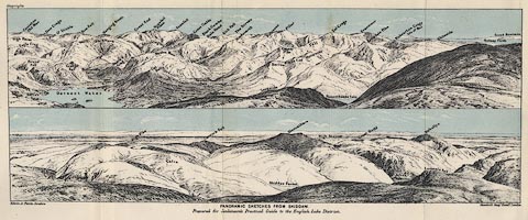 click to enlarge click to enlargeJk01E2.jpg "... Lingmell ..." item:- JandMN : 28.8 Image © see bottom of page |
|
|
|
||
| evidence:- | outline view:- Jenkinson 1875 placename:- Lingmell |
|
| source data:- | Print, lithograph, outline view, Panoramic Sketches from Scawfell Pike, Cumberland,
by Edwin A Pettitt, London, published by Edward Stanford, 55 Charing Cross, London,
1875.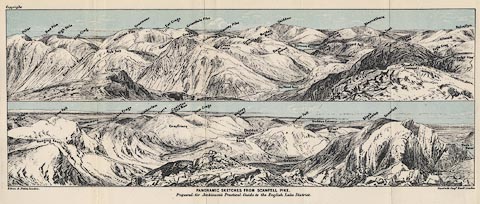 click to enlarge click to enlargeJk01E3.jpg "... Lingmell ..." item:- JandMN : 28.9 Image © see bottom of page |
|
|
|
||
| evidence:- | outline view:- Matthew 1866 placename:- Ling Mell |
|
| source data:- | Print, engraving, outline view, Mountains as seen from the Road to Wastwater near
Murthwaiteside, Cumberland, published by J Richardson, Highgate, Kendal, Westmorland,
1866.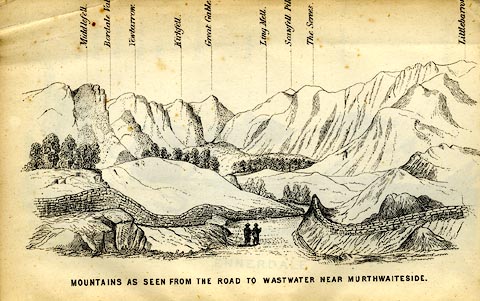 click to enlarge click to enlargeMW1E03.jpg Tipped in before p.1 of The English Lakes, Peaks and Passes, from Kendal to Keswick, by George King Matthew. printed at bottom:- "MOUNTAINS AS SEEN FROM THE ROAD TO WASTWATER NEAR MURTHWAITESIDE." printed at caption to mountains:- "... Ling Mell. ..." item:- Armitt Library : A1168.3 Image © see bottom of page |
|
|
|
||
| evidence:- | outline view:- Black 1856 (23rd edn 1900) placename:- Lingmell |
|
| source data:- | Print, lithograph, Outline Views, Haws and Wastwater - Mountains as seen from Burn-Banks
near the Foot of Hawes Water, and Mountains as seen near Nether Wastdale at the First
Bridge on the road to Wast-Water, by J Flintoft, Keswick, Cumberland, engraved by
R Mason, Edinburgh, Lothian, about 1900.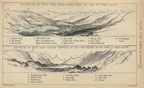 click to enlarge click to enlargeBC08E6.jpg "... 6 Lingmell ..." item:- JandMN : 37.21 Image © see bottom of page |
|
|
|
||
| evidence:- | outline view:- Linton 1852 placename:- Ling Mell |
|
| source data:- | Print, engraving, outline views, Mountains as Seen from the Esk Viaduct, the Eskmeals
Viaduct, and Mountains as Seen from the Viaduct near Drigg, the Irt Viaduct, Whitehaven
and Furness Junction Railway, Cumberland, engraved by W H Lizars, Edinburgh, published
by Whittaker and Co, London, and by R Gibson and Son and by Callander and Dixon, Whitehaven,
Cumberland, 1852.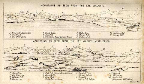 click to enlarge click to enlargeLN1E13.jpg Tipped in opposite p.86 of A Handbook of the Whitehaven and Furness Railway, by John Linton. item:- Armitt Library : A1158.11 Image © see bottom of page |
|
|
|
||
| evidence:- | outline view:- Black 1841 (3rd edn 1846) placename:- Lingmell |
|
| source data:- | Print, engraving, outline view, Mountains as seen from Burn Banks near the Foot of
Hawes Water, and Mountains as seen near Strands in Wastdale at the First bridge on
the Road to Wast Water, by J Flintoft, Keswick, Cumberland, engraved by R Mason, Edinburgh,
Lothian, about 1846.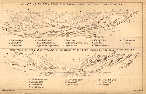 click to enlarge click to enlargeBC02E8.jpg "... 6 Lingmell ..." item:- JandMN : 32.12 Image © see bottom of page |
|
|
|
||
| evidence:- | outline view:- Tattersall 1836 (version 1869) placename:- Lingmell |
|
| source data:- | Print, hand coloured, Wast Water and Scawfell Pikes, from the road to Calder Bridge,
Nether Wasdale, Cumberland, drawn by George Tattersall, 1836, engraved by W F Topham,
published by T J Allman, 463 Oxford Street, London, 1869.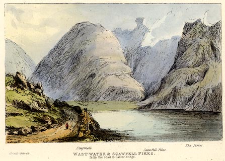 click to enlarge click to enlargeTAT214.jpg Included in The Lakes of England, by W F Topham. printed at bottom:- "WAST WATER &SCAWFELL PIKES, / from the road to Calder Bridge." printed at bottom:- "Great Gavel. / Lingmell. / Scawfell Pikes. / The Screes." item:- Armitt Library : A1067.14 Image © see bottom of page |
|
|
|
||
| evidence:- | outline view:- Tattersall 1836 (version 1869) placename:- Lingmell |
|
| source data:- | Print, hand coloured, Stye Head Tarn, Cumberland, drawn by George Tattersall, 1836,
engraved by W F Topham, published by T J Allman, 463 Oxford Street, London, 1869.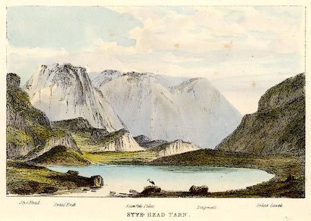 click to enlarge click to enlargeTAT213.jpg Included in The Lakes of England, by W F Topham. printed at bottom:- "STYE HEAD TARN." printed at bottom:- "Stye Head. / Great End. / Scawfell Pike. / Lingmell. / Great Gavel." item:- Armitt Library : A1067.13 Image © see bottom of page |
|
|
|
||
| evidence:- | outline view:- Tattersall 1836 placename:- Lingmell item:- fingerpost |
|
| source data:- | Print, engraving, Wast Water and Scawfell Pikes, from the road to Calder Bridge, Nether
Wasdale, Cumberland, drawn by George Tattersall, engraved by W F Topham, published
by Sherwood and Co, Paternoster Row, London, about 1836.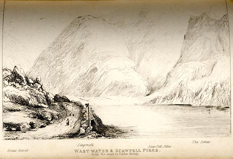 click to enlarge click to enlargeTAT132.jpg The print is captioned with mountain names and acts as an outline view. Tipped in opposite p.80 of The Lakes of England, by George Tattersall. printed at bottom:- "WAST WATER &SCAWFELL PIKES, / from the road to Calder Bridge." printed at bottom left to right:- "Great Gavel. / Lingmell. / Scawfell Pikes. / The Screes." item:- Armitt Library : A1204.33 Image © see bottom of page |
|
|
|
||
| evidence:- | outline view:- placename:- Lingmell |
|
| source data:- | Print, hand coloured engraving, Wast Water and Scawfell Pikes from the Road to Calder
Bridge, Cumberland, published by Sherwood and Co, London, 1836?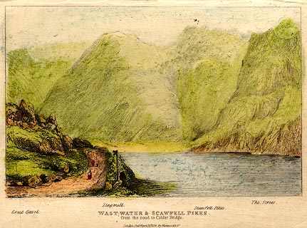 click to enlarge click to enlargePR0373.jpg Objects in the view are identified by a caption at the bottom - Great Gavel, Lingmell, Scawfell Pikes, The Screes. printed at bottom:- "WAST-WATER & SCAWFELL PIKES. / from the road to Calder Bridge. / London. Pubd. April 15th 1836 by Sherwood &Co." item:- Dove Cottage : 2008.107.373 Image © see bottom of page |
|
|
|
||
 BPF42.jpg (taken 20.5.2008) 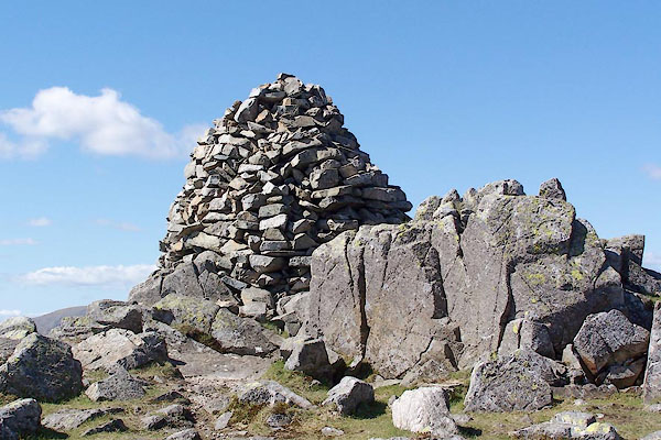 BQO24.jpg Cairn at the top, (taken 12.5.2009) 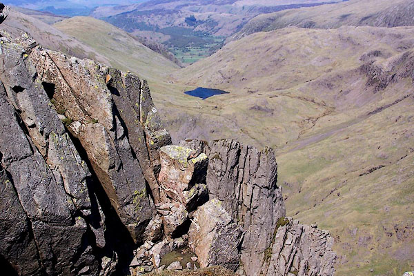 BQO23.jpg View from the summit, Styhead Tarn below. (taken 12.5.2009) 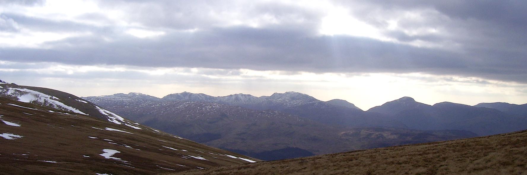 Click to enlarge BOV28.jpg Outline view from Stybarrow Dodd; Bowfell, Esk Pike, Scafell, Lingmell, Great Gable. (taken 17.3.2008) |
||
|
|
||
Lakes Guides menu.