 Old Cumbria Gazetteer
 |
 |
|
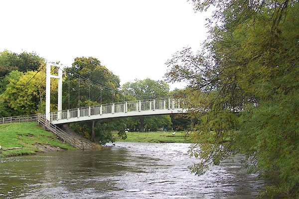
| Long Bridge, Keswick | ||
| Long Bridge | ||
| site name:- | Derwent, River | |
| site name:- | road, Keswick to Cockermouth (once) | |
| locality:- | Portinscale | |
| civil parish:- | Keswick (formerly Cumberland) | |
| civil parish:- | Above Derwent (formerly Cumberland) | |
| county:- | Cumbria | |
| locality type:- | footbridge | |
| coordinates:- | NY25352377 | |
| 1Km square:- | NY2523 | |
| 10Km square:- | NY22 | |
|
|
||
 BJX92.jpg (taken 14.10.2005) 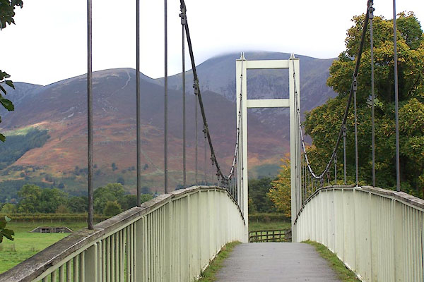 BJX93.jpg (taken 14.10.2005) |
||
|
|
||
| evidence:- | old map:- OS County Series (Cmd 64 1) placename:- Long Bridge |
|
| source data:- | Maps, County Series maps of Great Britain, scales 6 and 25
inches to 1 mile, published by the Ordnance Survey, Southampton,
Hampshire, from about 1863 to 1948. |
|
|
|
||
| evidence:- | old text:- placename:- Long Bridge |
|
| source data:- | Jervoise, E: 1931: Ancient Bridges of the North of England | |
|
|
||
| evidence:- | old map:- Saxton 1579 |
|
| source data:- | Map, hand coloured engraving, Westmorlandiae et Cumberlandiae Comitatus ie Westmorland
and Cumberland, scale about 5 miles to 1 inch, by Christopher Saxton, London, engraved
by Augustinus Ryther, 1576, published 1579-1645.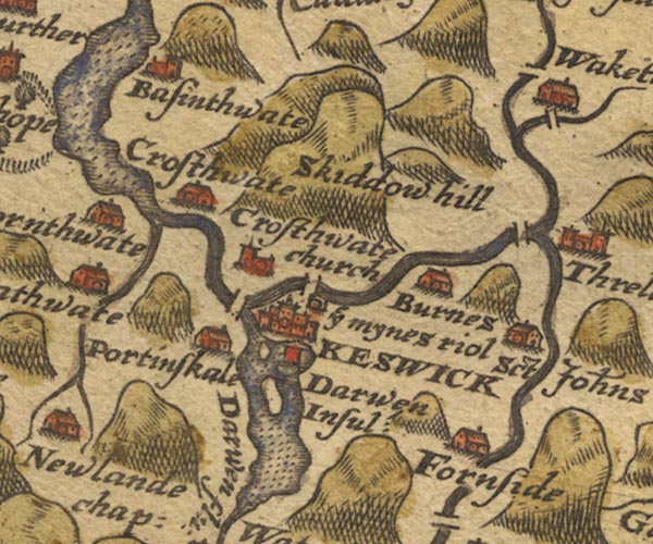 Sax9NY22.jpg W of Keswick. item:- private collection : 2 Image © see bottom of page |
|
|
|
||
| evidence:- | old map:- Mercator 1595 (edn?) placename:- |
|
| source data:- | Map, hand coloured engraving, Northumbria, Cumberlandia, et
Dunelmensis Episcopatus, ie Northumberland, Cumberland and
Durham etc, scale about 6.5 miles to 1 inch, by Gerard Mercator,
Duisberg, Germany, about 1595. MER8CumF.jpg "" double across a stream; bridge, over the Derwent item:- JandMN : 169 Image © see bottom of page |
|
|
|
||
| evidence:- | old map:- Speed 1611 (Cmd) |
|
| source data:- | Map, hand coloured engraving, Cumberland and the Ancient Citie
Carlile Described, scale about 4 miles to 1 inch, by John Speed,
1610, published by J Sudbury and George Humble, Popes Head
Alley, London, 1611-12.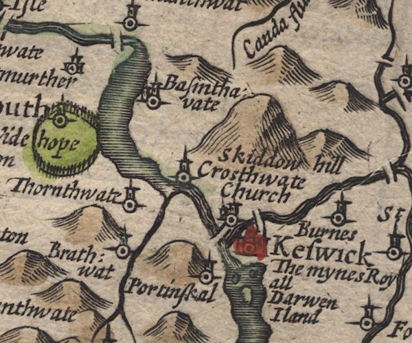 SP11NY22.jpg double line across the Derwent item:- private collection : 16 Image © see bottom of page |
|
|
|
||
| evidence:- | old map:- Jansson 1646 |
|
| source data:- | Map, hand coloured engraving, Cumbria and Westmoria, ie
Cumberland and Westmorland, scale about 3.5 miles to 1 inch, by
John Jansson, Amsterdam, Netherlands, 1646.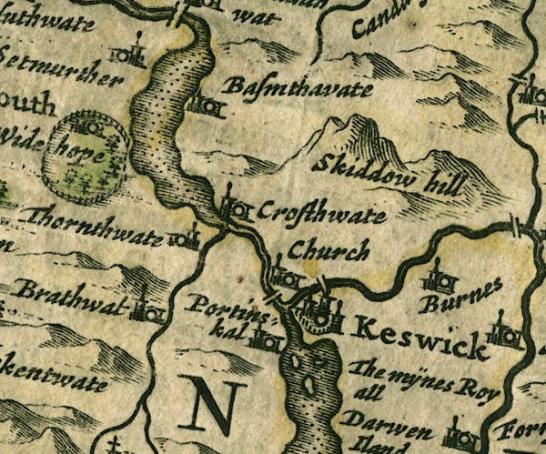 JAN3NY22.jpg Double line crossing the stream. item:- JandMN : 88 Image © see bottom of page |
|
|
|
||
| evidence:- | old map:- Sanson 1679 |
|
| source data:- | Map, hand coloured engraving, Ancien Royaume de Northumberland
aujourdhuy Provinces de Nort, ie the Ancient Kingdom of
Northumberland or the Northern Provinces, scale about 9.5 miles
to 1 inch, by Nicholas Sanson, Paris, France, 1679. click to enlarge click to enlargeSAN2Cm.jpg double line over a stream; bridge item:- Dove Cottage : 2007.38.15 Image © see bottom of page |
|
|
|
||
| evidence:- | old map:- Seller 1694 (Cmd) |
|
| source data:- | Map, uncoloured engraving, Cumberland, scale about 12 miles to 1
inch, by John Seller, 1694. click to enlarge click to enlargeSEL9.jpg two lines cross a stream; bridge item:- Dove Cottage : 2007.38.89 Image © see bottom of page |
|
|
|
||
| evidence:- | old map:- Morden 1695 (Cmd) |
|
| source data:- | Map, uncoloured engraving, Cumberland, scale about 4 miles to 1
inch, by Robert Morden, 1695, published by Abel Swale, the
Unicorn, St Paul's Churchyard, Awnsham, and John Churchill, the
Black Swan, Paternoster Row, London, 1695-1715.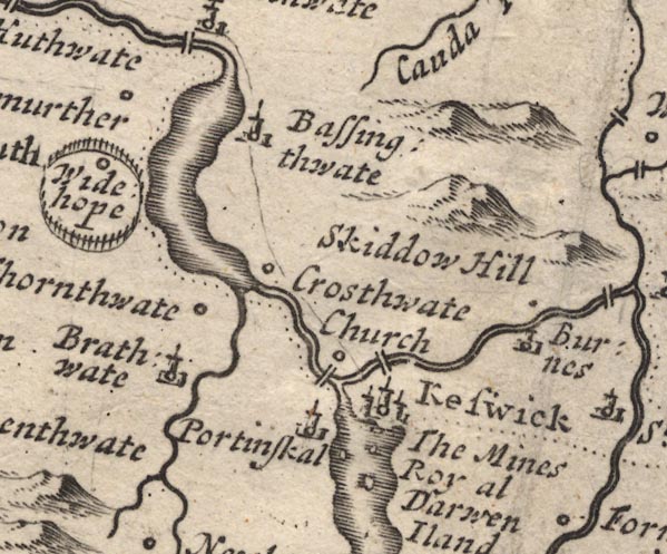 MD12NY22.jpg Double line over the Derwent, below Keswick. item:- JandMN : 90 Image © see bottom of page |
|
|
|
||
| evidence:- | old map:- Donald 1774 (Cmd) |
|
| source data:- | Map, hand coloured engraving, 3x2 sheets, The County of Cumberland, scale about 1
inch to 1 mile, by Thomas Donald, engraved and published by Joseph Hodskinson, 29
Arundel Street, Strand, London, 1774. D4NY22SE.jpg double line across a river; a bridge over the Derwent near Great Crosthwaite item:- Carlisle Library : Map 2 Image © Carlisle Library |
|
|
|
||
| evidence:- | old map:- Crosthwaite 1783-94 (Der) |
|
| source data:- | Map, uncoloured engraving, An Accurate Map of the Matchless Lake
of Derwent, ie Derwent Water, scale about 3 inches to 1 mile, by
Peter Crosthwaite, Keswick, Cumberland, 1783, version published
1800.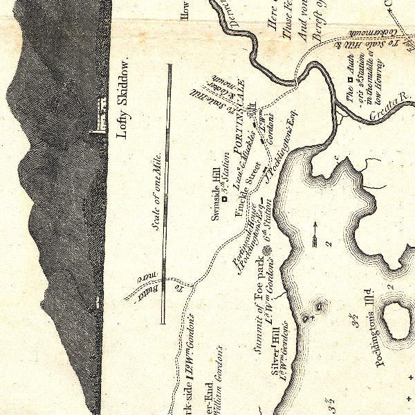 CT2NY22K.jpg Keswick to Cockermouth road over the River Derwent. item:- Armitt Library : 1959.191.3 Image © see bottom of page |
|
|
|
||
| evidence:- | old map:- Clarke 1787 map (Der) placename:- |
|
| source data:- | Map, uncoloured engraving, Map of Derwentwater and its Environs,
scale about 13 ins to 1 mile, by James Clarke, engraved by S J
Neele, published by James Clarke, Penrith, Cumberland and in
London etc, 1787.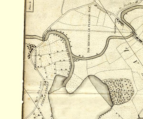 CL152523.jpg road bridge over the Derwent item:- private collection : 169 Image © see bottom of page |
|
|
|
||
| evidence:- | old map:- Otley 1818 |
|
| source data:- | Map, uncoloured engraving, The District of the Lakes,
Cumberland, Westmorland, and Lancashire, scale about 4 miles to
1 inch, by Jonathan Otley, 1818, engraved by J and G Menzies,
Edinburgh, Scotland, published by Jonathan Otley, Keswick,
Cumberland, et al, 1833.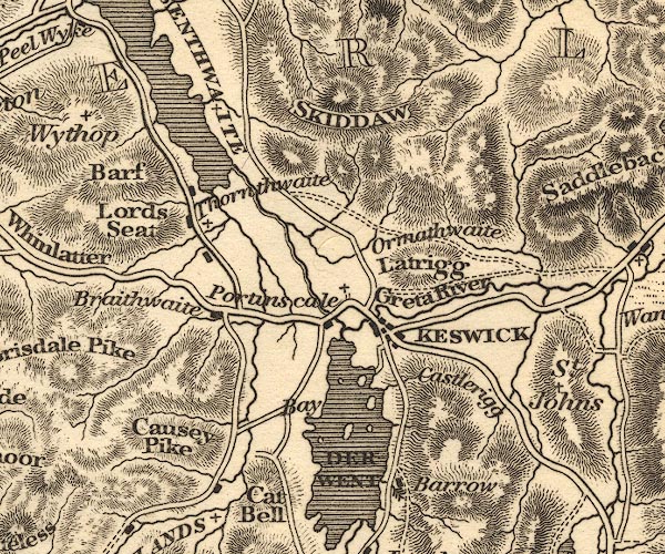 OT02NY22.jpg Implied by a road across the stream. item:- JandMN : 48.1 Image © see bottom of page |
|
|
|
||
| evidence:- | old print:- Westall 1820 placename:- Portinscale Bridge |
|
| source data:- | Print, uncoloured mezzotint, Portinscale Bridge, near Keswick, Cumberland, drawn and
engraved by William Westall, published by Rodwell and Martin, New Bond Street, London,
1820.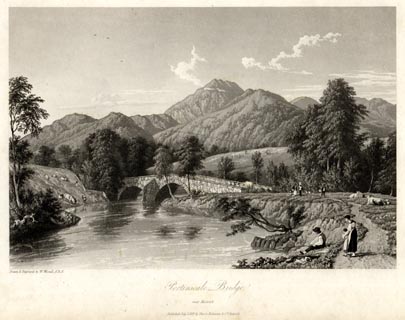 click to enlarge click to enlargeWTL110.jpg printed, bottom left, centre "Drawn & Engraved by W. Westall A.R.A. / Portinscale Bridge, / near Keswick. / Published July 1, 1819, by Hurst, Robinson &Co. Cheapside." item:- Armitt Library : A6671.10 Image © see bottom of page |
|
|
|
||
| evidence:- | old print:- Green 1822 (plate 22) placename:- Long Bridge |
|
| source data:- | Print, uncoloured soft ground etching, Long Bridge near Keswick, Cumberland, by William
Green, Ambleside, Westmorland, 1822.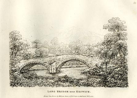 click to enlarge click to enlargeGN0822.jpg Plate 22 in Forty Etchings from Nature. printed at bottom:- "LONG BRIDGE near KESWICK. / Etched from Nature by William Green, &Published at Ambleside, Feby. 1, 1822." item:- Armitt Library : A6644.22 Image © see bottom of page |
|
|
|
||
| evidence:- | old map:- Bell 1892 placename:- Long Bridge |
|
| source data:- | Map, colour lithograph, Road Map of Cumberland, by George Joseph
Bell, scale about 2.5 miles to 1 inch, printed by Charles
Thurnam and Sons, Carlisle, Cumberland, 1892. BEL9NY22.jpg "L[ ] BRIDGE" bridge symbol Road map of Cumberland showing County Bridges item:- Carlisle Library : Map 38 Image © Carlisle Library |
|
|
|
||
| evidence:- | old print:- Bradley 1901 placename:- Portinscale Bridge |
|
| source data:- | Print, uncoloured lithograph, Portinscale Bridge, Long Bridge, Portinscale, Cumberland,
by Joseph Pennell, published by Macmillan and Co, London, 1901.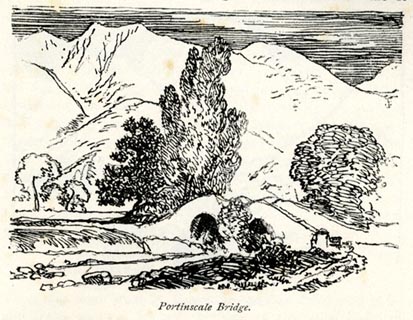 click to enlarge click to enlargeBRL117.jpg On page 95 of Highways and Byways in the Lake District, by A G Bradley. printed at bottom:- "Portinscale Bridge." item:- JandMN : 464.17 Image © see bottom of page |
|
|
|
||
| evidence:- | old print:- Pearson 1900s |
|
| source data:- | Print, halftone photograph, Bridge near Portinscales, probably Long Bridge, Keswick,
Cumberland, published by C Arthur Pearson, Henrietta Street, London, 1900s.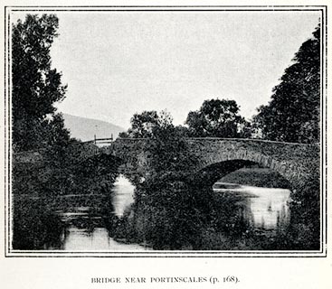 click to enlarge click to enlargePS1E62.jpg On p.169 of Pearson's Gossipy Guide to the English Lakes and Neighbouring Districts. printed at bottom:- "BRIDGE NEAR PORTINSCALES (p.168)." item:- Armitt Library : A1188.69 Image © see bottom of page |
|
|
|
||
| evidence:- | probably old painting:- placename:- Portinscale Bridge |
|
| source data:- | Painting, watercolour, Portinscale Bridge, ?Long Bridge, Keswick, Cumberland, by Samuel
Bough, 1850.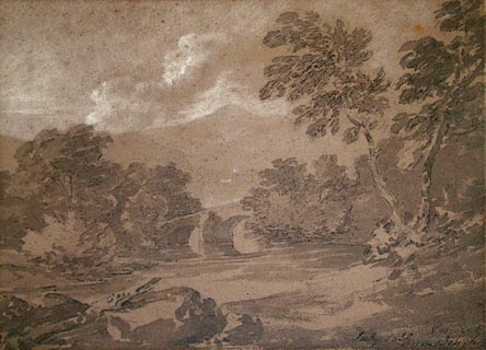 click to enlarge click to enlargePR0980.jpg Boulders lie in foreground; a river with tree lined banks flows beneath a partially obscured stone bridge. Beyond lies Keswick, above which rise rocky fells. signed &dated at bottom right:- "July 1850 Keswick Sam Bough" item:- Tullie House Museum : 1960.52.1 Image © Tullie House Museum |
|
|
|
||
| hearsay:- |
The present structure is a recent replacement. |
|
| The route across this bridge was once a turnpike. This is probably the Long Bridge
mentioned by Jervoise, and the once important bridge for the west route from Keswick,
to Cockermouth. |
||
|
|
||
 Lakes Guides menu.