 Old Cumbria Gazetteer
 |
 |
|
| Lowther Park, Lowther | ||
| Lowther Park | ||
| civil parish:- | Lowther (formerly Westmorland) | |
| county:- | Cumbria | |
| locality type:- | park | |
| coordinates:- | NY52112428 (etc) | |
| 1Km square:- | NY5224 | |
| 10Km square:- | NY52 | |
|
|
||
| evidence:- | old map:- Morden 1695 (Wmd) |
|
| source data:- | Map, hand coloured engraving, Westmorland, scale about 2.5 miles to 1 inch, by Robert
Morden, published by Abel Swale, the Unicorn, St Paul's Churchyard, Awnsham, and John
Churchill, the Black Swan, Paternoster Row, London, 1695.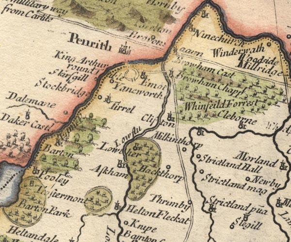 MD10NY52.jpg Ring of fence palings, trees. item:- JandMN : 24 Image © see bottom of page |
|
|
|
||
| evidence:- | old map:- Simpson 1746 map (Wmd) placename:- Lowther |
|
| source data:- | Map, uncoloured engraving, Westmorland, scale about 8 miles to 1
inch, printed by R Walker, Fleet Lane, London, 1746.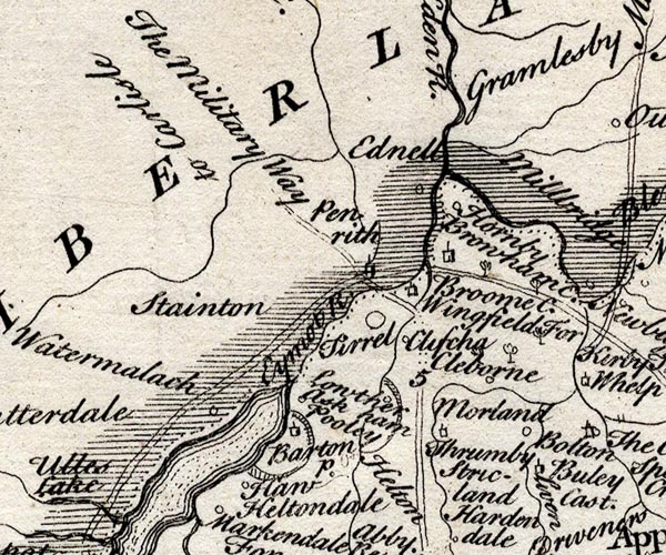 SMP2NYL.jpg "Lowther" Circle and outline for the park. item:- Dove Cottage : 2007.38.59 Image © see bottom of page |
|
|
|
||
| evidence:- | old text:- Gents Mag |
|
| source data:- | Magazine, The Gentleman's Magazine or Monthly Intelligencer or
Historical Chronicle, published by Edward Cave under the
pseudonym Sylvanus Urban, and by other publishers, London,
monthly from 1731 to 1922. goto source goto sourceGentleman's Magazine 1766 p.166 "... Lord Lonsdale's house and park, and a large extent of his estates, beautifully interspersed with woods, water, and rich pasture, and meadow grounds, which still seem more delightful, because of the immediate transition, from barren rocks to one of the richest vales imaginable. ..." |
|
|
|
||
| evidence:- | descriptive text:- West 1778 (11th edn 1821) |
|
| source data:- | Guide book, A Guide to the Lakes, by Thomas West, published by
William Pennington, Kendal, Cumbria once Westmorland, and in
London, 1778 to 1821. goto source Addendum; Mr Gray's Journal, 1769 Page 200:- "... walked up beacon-hill [Penrith], a mile to the top, and could see ... Whinfield and Lowther parks, &c." |
|
|
|
||
| evidence:- | old map:- West 1784 map |
|
| source data:- | Map, hand coloured engraving, A Map of the Lakes in Cumberland,
Westmorland and Lancashire, scale about 3.5 miles to 1 inch,
engraved by Paas, 53 Holborn, London, about 1784.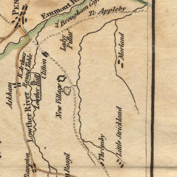 Ws02NY52.jpg Marked by a drawing of a building in a park enclosed by the river and a paling fence. item:- Armitt Library : A1221.1 Image © see bottom of page |
|
|
|
||
| evidence:- | descriptive text:- Baker 1802 |
|
| source data:- | Perspective road map with sections in Lancashire, Westmorland,
and Cumberland, by J Baker, London 1802. pp.25-26:- "Near this passage [road to Penrith] is also the seat and extensive park of Lord Lonsdale, ... observable from the woods and smaller plantations of furs and other evergreens, tastefully arranged on the summits of the hills near them. Lowther Hall, next passed, is another possession of the family of that name. ..." |
|
|
|
||
| evidence:- | old map:- Cooke 1802 placename:- Lowther |
|
| source data:- | Map, Westmoreland ie Westmorland, scale about 12 miles to 1
inch, by George Cooke, 1802, published by Sherwood, Jones and
Co, Paternoster Road, London, 1824. click to enlarge click to enlargeGRA1Wd.jpg "Lowther" outline of fence palings; park item:- Hampshire Museums : FA2000.62.4 Image © see bottom of page |
|
|
|
||
| evidence:- | old map:- Wallis 1810 (Wmd) placename:- Lowther |
|
| source data:- | Road map, Westmoreland, scale about 19 miles to 1 inch, by James
Wallis, 77 Berwick Street, Soho, 1810, published by W Lewis,
Finch Lane, London, 1835? click to enlarge click to enlargeWAL5.jpg "Lowther" outline with fence palings; park item:- JandMN : 63 Image © see bottom of page |
|
|
|
||
| evidence:- | descriptive text:- Ford 1839 (3rd edn 1843) placename:- Lowther Park |
|
| source data:- | Guide book, A Description of Scenery in the Lake District, by
Rev William Ford, published by Charles Thurnam, Carlisle, by W
Edwards, 12 Ave Maria Lane, Charles Tilt, Fleet Street, William
Smith, 113 Fleet Street, London, by Currie and Bowman,
Newcastle, by Bancks and Co, Manchester, by Oliver and Boyd,
Edinburgh, and by Sinclair, Dumfries, 1839. goto source Page 135:- "..." "LOWTHER CASTLE AND PARK." "The Castle stands in a park of six hundred acres, on the east side of the delightful vale of Lowther. ..." goto sourcePage 137:- "The tourist who has complained of the deficiency of magnificent forest-wood, will here, at least, have found no reason to renew his complaints, and, indeed, scarcely during any of the latter part of the tour. The princely residences of the nobility are scarce in the north country - the halls of the gentry are not numerous - and the lands being in the hands of statesmen, who are in general mere agriculturalists, they look upon wood as exhausting the fertility of the land." |
|
|
|
||
| evidence:- | old text:- Martineau 1855 item:- yew; storm; hurricane; weather |
|
| source data:- | Guide book, A Complete Guide to the English Lakes, by Harriet
Martineau, published by John Garnett, Windermere, Westmorland,
and by Whittaker and Co, London, 1855; published 1855-76. goto source Page 171:- "... The traveller should walk along the river bank ... to Askham, and then ascend the steep bank of red sandstone, overshadowed by trees, to the park of Lowther Castle. The grounds here are fine; especially the terrace, which affords a noble walk. It is very elevated; broad, mossy, shady, breezy, and overlooking a considerable extent of country,- some of which is fertile plain, and some undulating surface,- the margin of the mountain region. The most remarkable feature of this landscape is perhaps the hol-" goto sourcePage 172:- "[hol]low, within which lies Hawes Water. The park has some fine old trees; and the number and size of the yews in the grounds will strike the stranger. But lasting injury was done to the woods by the hurricane of 1839, which broke its way straight through, levelling every thing in its path. On the road from Askham to Bampton, the high grounds of Lowther present on the left a nearly straight line of great elevation, along which runs the park wall, almost to the extremity of the promontory. From a distance, it looks the most enviable position for a park that can be imagined." |
|
|
|
||
| evidence:- | old print:- Bogg 1898 |
|
| source data:- | Print, engraving, Vale of Lowther, Lowther Park, Lowther, Westmorland, by A Haselgrave,
published by Edmund Bogg, 3 Woodhouse Lane, and James Miles, Guildford Street, Leeds,
Yorkshire, 1898.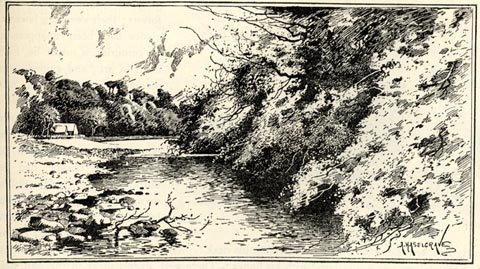 click to enlarge click to enlargeBGG134.jpg Included on p.129 of Lakeland and Ribblesdale, by Edmund Bogg. item:- JandMN : 231.34 Image © see bottom of page |
|
|
|
||
| evidence:- | old print:- Rose 1832-35 |
|
| source data:- | Print, engraving, Lowther Castle and Park, Westmorland, by Thomas Allom, engraved
by W le Petit, 1830s.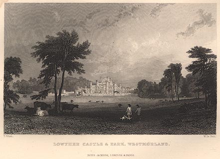 click to enlarge click to enlargeR2E33.jpg item:- JandMN : 66.18 Image © see bottom of page |
|
|
|
||
| evidence:- | old print:- Lowther 1780s-90s item:- garden |
|
| source data:- | Print, engraving, Lowther, Westmorland now Cumbria, 1700s.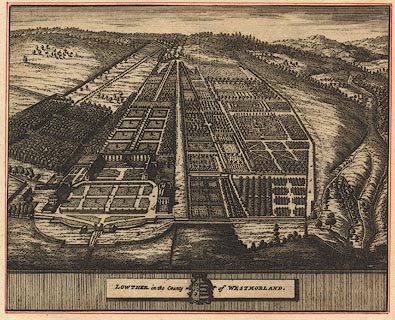 click to enlarge click to enlargeBNF15.jpg The house and gardens and surrounding lands are drawn in bird's eye view. Copied from the Knyff and Kip print? item:- Dove Cottage : Lowther.28 Image © see bottom of page |
|
|
|
||
| evidence:- | old print:- Knyff and Kip 1707 |
|
| source data:- | Print, engraving, Lowther, Westmorland now Cumbria, drawn by Leonard Knyff, engraved
by John Kip, 1707.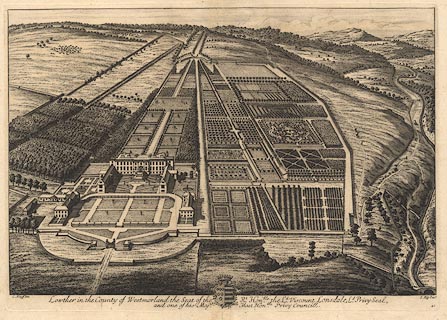 click to enlarge click to enlargeBNF17.jpg The house and gardens and surrounding lands are drawn in bird's eye view. Probably from Britannia Illustrata, published London, 1707-1740. item:- Dove Cottage : Lowther.30 Image © see bottom of page |
|
|
|
||
Lakes Guides menu.