 Old Cumbria Gazetteer
 |
 |
|
| Maulds Meaburn Moor, Crosby Ravensworth | ||
| Maulds Meaburn Moor | ||
| civil parish:- | Crosby Ravensworth (formerly Westmorland) | |
| county:- | Cumbria | |
| locality type:- | moor | |
| coordinates:- | NY64521506 (etc) | |
| 1Km square:- | NY6415 | |
| 10Km square:- | NY61 | |
|
|
||
| evidence:- | old map:- OS County Series (Wmd 15 13) placename:- Maulds Meaburn Moor |
|
| source data:- | Maps, County Series maps of Great Britain, scales 6 and 25
inches to 1 mile, published by the Ordnance Survey, Southampton,
Hampshire, from about 1863 to 1948. |
|
|
|
||
| evidence:- | old map:- Jefferys 1770 (Wmd) placename:- Ravensworth and Meaburn Moor |
|
| source data:- | Map, 4 sheets, The County of Westmoreland, scale 1 inch to 1
mile, surveyed 1768, and engraved and published by Thomas
Jefferys, London, 1770.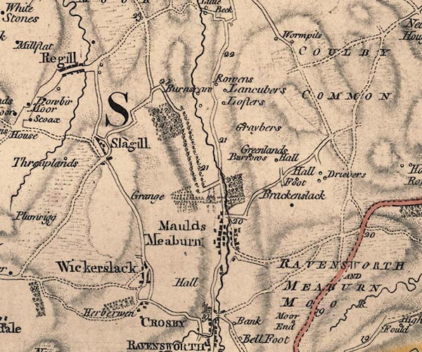 J5NY61NW.jpg "RAVENSWORTH AND MEABURN MOOR" area item:- National Library of Scotland : EME.s.47 Image © National Library of Scotland |
|
|
|
||
| evidence:- | old map:- Cary 1789 (edn 1805) placename:- Ravensworth Moor |
|
| source data:- | Map, uncoloured engraving, Westmoreland, scale about 2.5 miles
to 1 inch, by John Cary, London, 1789; edition 1805.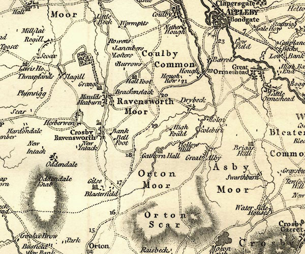 CY24NY61.jpg "Ravensworth Moor" area item:- JandMN : 129 Image © see bottom of page |
|
|
|
||
| evidence:- | old map:- Laurie and Whittle 1806 placename:- Meaburn Moor |
|
| source data:- | Road map, Continuation of the Roads to Glasgow and Edinburgh,
scale about 10 miles to 1 inch, by Nathaniel Coltman? 1806,
published by Robert H Laurie, 53 Fleet Street, London, 1834. click to enlarge click to enlargeLw21.jpg "Ravensworth &Meaburn Moor" area item:- private collection : 18.21 Image © see bottom of page |
|
|
|
||
 Lakes Guides menu.