 Old Cumbria Gazetteer
 |
 |
|
| Netherby, Arthuret | ||
| out of sight | ||
| Netherby | ||
| Netherby Hall | ||
| civil parish:- | Arthuret (formerly Cumberland) | |
| county:- | Cumbria | |
| locality type:- | buildings | |
| locality type:- | park | |
| locality type:- | flood | |
| coordinates:- | NY39667161 | |
| 1Km square:- | NY3971 | |
| 10Km square:- | NY37 | |
|
|
||
| evidence:- | old map:- OS County Series (Cmd 6 15) placename:- Netherby placename:- Castra Exploratorum |
|
| source data:- | Maps, County Series maps of Great Britain, scales 6 and 25
inches to 1 mile, published by the Ordnance Survey, Southampton,
Hampshire, from about 1863 to 1948. "Netherby / CASTRA EXPLORATORUM (Site of)" |
|
|
|
||
| evidence:- | old map:- Saxton 1579 placename:- Netherbye |
|
| source data:- | Map, hand coloured engraving, Westmorlandiae et Cumberlandiae Comitatus ie Westmorland
and Cumberland, scale about 5 miles to 1 inch, by Christopher Saxton, London, engraved
by Augustinus Ryther, 1576, published 1579-1645.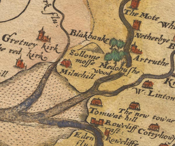 Sax9NY36.jpg Tower, symbol for a house, hall, tower, etc. "Netherbye" item:- private collection : 2 Image © see bottom of page |
|
|
|
||
| evidence:- | old map:- Burghley 1590 (facsimile) placename:- Netherbie |
|
| source data:- | Facsimile map, A Platt of the Opposete Border of Scotland to ye West Marches of England,
parts of Cumberland and Scotland including the Debateable Land, from a manuscript
drawn for William Cecil, Lord Burghley, about 1590, published by R B Armstrong, 1897. courtesy of the National Library of Scotland  M048NY47.jpg "Netherbie" circle, tower, cross item:- National Library of Scotland : MS6113 f.267 Image © National Library of Scotland |
|
|
|
||
| evidence:- | old map:- Speed 1611 (Cmd) placename:- Netherby |
|
| source data:- | Map, hand coloured engraving, Cumberland and the Ancient Citie
Carlile Described, scale about 4 miles to 1 inch, by John Speed,
1610, published by J Sudbury and George Humble, Popes Head
Alley, London, 1611-12.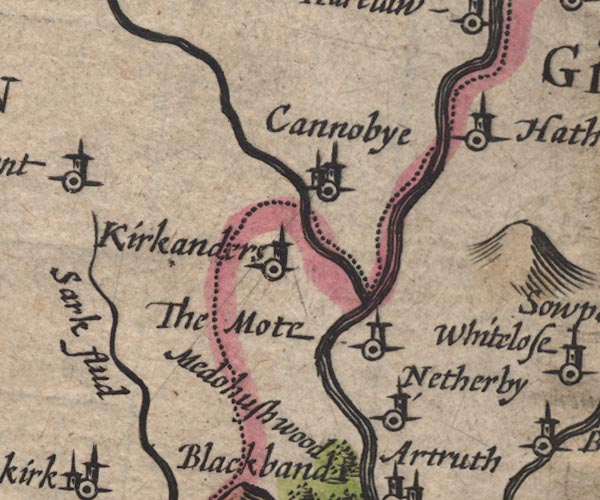 SP11NY37.jpg "Netherby" circle, tower item:- private collection : 16 Image © see bottom of page |
|
|
|
||
| evidence:- | old map:- Jansson 1646 placename:- Netherby |
|
| source data:- | Map, hand coloured engraving, Cumbria and Westmoria, ie
Cumberland and Westmorland, scale about 3.5 miles to 1 inch, by
John Jansson, Amsterdam, Netherlands, 1646. JAN3NY47.jpg "Netherbÿ" Buildings and tower. item:- JandMN : 88 Image © see bottom of page |
|
|
|
||
| evidence:- | old map:- Seller 1694 (Cmd) placename:- Netherby |
|
| source data:- | Map, uncoloured engraving, Cumberland, scale about 12 miles to 1
inch, by John Seller, 1694. click to enlarge click to enlargeSEL9.jpg "Netherby" circle, italic lowercase text; settlement or house item:- Dove Cottage : 2007.38.89 Image © see bottom of page |
|
|
|
||
| evidence:- | old map:- Morden 1695 (Cmd) placename:- Netherby |
|
| source data:- | Map, uncoloured engraving, Cumberland, scale about 4 miles to 1
inch, by Robert Morden, 1695, published by Abel Swale, the
Unicorn, St Paul's Churchyard, Awnsham, and John Churchill, the
Black Swan, Paternoster Row, London, 1695-1715.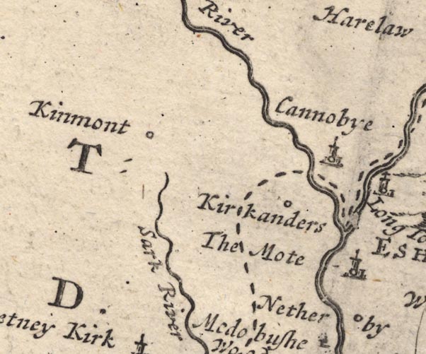 MD12NY37.jpg "Netherby" Circle. item:- JandMN : 90 Image © see bottom of page |
|
|
|
||
| evidence:- | probably old map:- Bowen and Kitchin 1760 placename:- Netherby |
|
| source data:- | Map, hand coloured engraving, A New Map of the Counties of
Cumberland and Westmoreland Divided into their Respective Wards,
scale about 4 miles to 1 inch, by Emanuel Bowen and Thomas
Kitchin et al, published by T Bowles, Robert Sayer, and John
Bowles, London, 1760.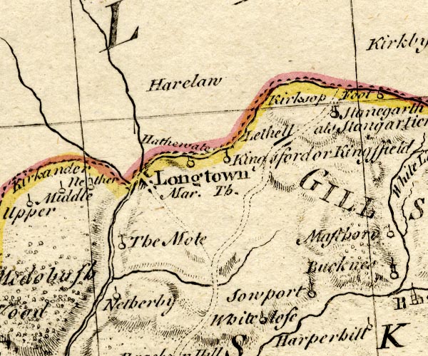 BO18NY47.jpg "Netherby" circle and line item:- Armitt Library : 2008.14.10 Image © see bottom of page |
|
|
|
||
| evidence:- | old text:- Pennant 1773 placename:- Netherby |
|
| source data:- | Book, A Tour from Downing to Alston Moor, 1773, by Thomas
Pennant, published by Edward Harding, 98 Pall Mall, London, 1801. goto source goto sourcePennant's Tour 1773, page 182 "... reached Netherby, where I again experienced the hospitality of its owner, the Reverend Mr. Graham†. Numbers of pieces of antiquity had been collected here since my former visit to this place." " †He died February 2, 1782; was succeeded by his son Charles, who died soon after; he was succeeded by his brother James, created a Baronet December 28, 1782.." |
|
|
|
||
| evidence:- | old map:- Donald 1774 (Cmd) placename:- Netherby |
|
| source data:- | Map, hand coloured engraving, 3x2 sheets, The County of Cumberland, scale about 1
inch to 1 mile, by Thomas Donald, engraved and published by Joseph Hodskinson, 29
Arundel Street, Strand, London, 1774. D4NY47SW.jpg "Netherby / Graham Esq." house item:- Carlisle Library : Map 2 Image © Carlisle Library |
|
|
|
||
| evidence:- | old map:- Pennant 1777 placename:- Netherby placename:- Castra Exploratorum |
|
| source data:- | Map, hand coloured engraving, A Map of Scotland, Hebrides and
Part of England, drawn for Thomas Pennant, engraved by J Bayly,
published by Benjamin White, London, 1777. click to enlarge click to enlargePEN1Cm.jpg "NETHERBY / CAST EXPL" circle; buildings, village, etc item:- private collection : 66 Image © see bottom of page |
|
|
|
||
| evidence:- | old text:- Camden 1789 (Gough Additions) item:- irruption, Solway Moss; flood, 1771; drainage |
|
| source data:- | Book, Britannia, or A Chorographical Description of the Flourishing Kingdoms of England,
Scotland, and Ireland, by William Camden, 1586, translated from the 1607 Latin edition
by Richard Gough, published London, 1789. goto source Page 197:- "..." "Horsley puts here [roman fort, Netherby] CASTRA EXPLORATORUM. The rev. Mr. Graham's house stands on the site of the station, on a rising ground washed by the Esk; and the country round him is a creation of his own. From a barren wild it became as rich as the rest which environed it. By the irruption of Solway moss, 1769, a tract worth £.400. a year was reduced to a bog. This estate passed from the Stutevilles to the Wakes, and was granted as debateable land by James I. to Francis Clifford, earl of Cumberland, who sold it to Nicholas Graham, master of the horse to the duke of Buckingham, and of the prince's party in his Spanish journey. He was left for dead at the battle of Edgehill, but survived to 1653. His grandson George was created by Charles II. viscount Preston in the kingdom of Scotland, and being convicted of treason for attempting to escape to James II. in France, was pardoned, and died 1695 at Nunnington, his estate in Yorkshire, where he was succeeded by his grandson Charles; who dying without issue 1739, was succeeded by his two aunts, coheirs of William. Catherine surviving was married to William lord Widdrington, and dying 1757 without issue, devised the estate to the rev. Robert Graham, M.A. second son of her uncle William Graham, dean of Carlisle and of Wells, owner 1775 of this vast tract of country, and rector of the two churches of Asthurst and Kirkandrews upon Esk. He died, and was succeeded by his son sir James Graham. A writer in the Gent. Mag. LV. 844. observes that by draining, manuring, and planting, this worthy gentleman improved his estate in 16 years from £.2000. per annum, to £.10,000. and even £.13,000 per annum, so that if his son pursues his plan it will amount to £.20,000 per annum clear. He first drained and improved 1000 acres, then erected villages of eight or ten houses, with a number of acres to each, and let them to his industrious married neighbours rent free for one or two years or more till they could pay, besides erecting churches and inns, and a very handsome commodious house for himself, where the most liberal hospitality presided." |
|
|
|
||
| evidence:- | road book:- Cary 1798 (2nd edn 1802) placename:- Netherby |
|
| source data:- | Road book, itineraries, Cary's New Itinerary, by John Cary, 181
Strand, London, 2nd edn 1802. goto source click to enlarge click to enlargeC38273.jpg page 273-274 "2 Miles beyond Longtown, on r. is Netherby, Sir J. Graham, Bart." goto source click to enlarge click to enlargeC38289.jpg page 289-290 "2 Miles beyond Longtown, on r. is Netherby, Sir J. Graham, Bart." item:- JandMN : 228.1 Image © see bottom of page |
|
|
|
||
| evidence:- | old map:- Cooper 1808 placename:- Netherby |
|
| source data:- | Map, uncoloured engraving, Cumberland, scale about 10.5 miles to
1 inch, drawn and engraved by Cooper, published by R Phillips,
Bridge Street, Blackfriars, London, 1808. click to enlarge click to enlargeCOP3.jpg "Netherby" circle; village or hamlet item:- JandMN : 86 Image © see bottom of page |
|
|
|
||
| evidence:- | old text:- Gents Mag item:- storm, 1816; hurricane; greenhouse |
|
| source data:- | Magazine, The Gentleman's Magazine or Monthly Intelligencer or
Historical Chronicle, published by Edward Cave under the
pseudonym Sylvanus Urban, and by other publishers, London,
monthly from 1731 to 1922. goto source Gentleman's Magazine 1816 part 2 p.173 "COUNTRY NEWS" "July 21. A tremendous storm of thunder and lightning, with heavy rain, was experienced in Lancashire, and the adjoining counties. ... The same afternoon the hurricane visited Longtown and the neighbourhood. At Netherby upwards of 700 panes of glass were broken in the hot-houses of Sir James Graham, bart.; and 60 squares in the house were driven in with great violence by the hail-stones. ..." |
|
|
|
||
| evidence:- | old map:- Hall 1820 (Cmd) placename:- Netherby |
|
| source data:- | Map, hand coloured engraving, Cumberland, scale about 21 miles
to 1 inch, engraved by Sidney Hall, published by S Leigh, 18
Strand, London, 1820-31. click to enlarge click to enlargeHA14.jpg "Netherby" circle, italic lowercase text; settlement item:- JandMN : 91 Image © see bottom of page |
|
|
|
||
| evidence:- | old map:- Ford 1839 map placename:- Netherby |
|
| source data:- | Map, uncoloured engraving, Map of the Lake District of
Cumberland, Westmoreland and Lancashire, scale about 3.5 miles
to 1 inch, published by Charles Thurnam, Carlisle, and by R
Groombridge, 5 Paternoster Row, London, 3rd edn 1843.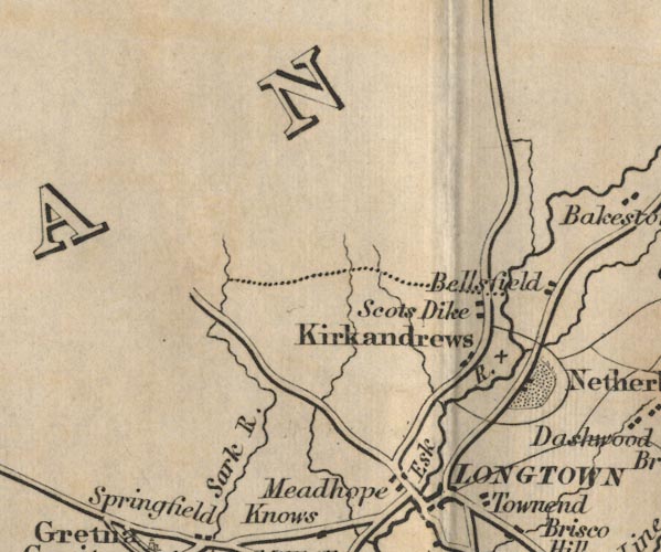 FD02NY37.jpg "Netherby" Park and buildings. item:- JandMN : 100.1 Image © see bottom of page |
|
|
|
||
| evidence:- | database:- Listed Buildings 2010 placename:- Netherby Hall item:- date stone (1639); 1630s |
|
| source data:- | courtesy of English Heritage "NETHERBY HALL / / / ARTHURET / CARLISLE / CUMBRIA / II[star] / 78101 / NY3966371613" |
|
|
|
||
| evidence:- | database:- Listed Buildings 2010 placename:- Coop House |
|
| source data:- | courtesy of English Heritage "COOP HOUSE NORTH WEST OF NETHERBY HALL / / / ARTHURET / CARLISLE / CUMBRIA / II[star] / 78104 / NY3866971474" |
|
|
|
||
| evidence:- | database:- Listed Buildings 2010 |
|
| source data:- | courtesy of English Heritage "COACHMAN'S HOUSE AND STABLES ADJOINING TO NORTH OF NETHERBY HALL / / / ARTHURET / CARLISLE / CUMBRIA / II / 78102 / NY3964371673" |
|
|
|
||
| evidence:- | old print:- Rose 1832-35 (vol.2 no.25) placename:- Netherby |
|
| source data:- | Print, uncoloured engraving, Netherby, Cumberland, drawn by Thomas Allom, engraved
by J C Bentley, published by Fisher, Son and Co, London, 1832-35.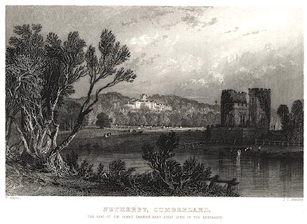 click to enlarge click to enlargePR0029.jpg vol.2 pl.25 in the set of prints, Westmorland, Cumberland, Durham and Northumberland Illustrated. printed at bottom left, right, centre:- "T. Allom. / J.C.Bentley. / NETHERBY, CUMBERLAND. / THE SEAT OF SIR JAMES GRAHAM, FIRST LORD OF THE ADMIRALTY." item:- Dove Cottage : 2008.107.29 Image © see bottom of page |
|
|
|
||
| story:- |
Anthony Berry Rudge age 45, James Martin alias John White age 36, James Baker also
known as John age 29, and a fourth man, a gang from London, carried out a burglary
at Netherby in the evening of 28 October 1885. They only took some jewelry, probably
being disturbed by a passing housemaid. The burglary was discovered quickly; the police
at Longtown were informed, and a chase began. |
|
| About 11pm they were confronted at Kingstown by Sergeant John Rhodes, and PC Jacob
Johnstone, of the Cumberland and Westmorland Constabulary. Both constables were shot
and wounded. Another posse of constables were warded off by threats of shooting. |
||
| Eventually they were approached near Plumpton Wall by PC Joseph Byrnes, whom they
shot and killed. There is a memorial to him in the village. Three of the gang were
caught, and hanged at Carlisle. |
||
|
|
||
| notes:- |
Netherby and also The Mote are shown on different maps north or south of Longtown. |
|
|
|
||
| notes:- |
tower incorporated in later house |
|
| Perriam, D R &Robinson, J: 1998: Medieval Fortified Buildings of Cumbria: CWAAS::
ISBN 1 873124 23 6; plan and illustrations |
||
|
|
||
Lakes Guides menu.