 Old Cumbria Gazetteer
 |
 |
|
| Orrest Head, Windermere | ||
| Orrest Head | ||
| civil parish:- | Windermere (formerly Westmorland) | |
| county:- | Cumbria | |
| locality type:- | hill | |
| locality type:- | viewpoint | |
| coordinates:- | SD41429935 | |
| 1Km square:- | SD4199 | |
| 10Km square:- | SD49 | |
| altitude:- | 781 feet | |
| altitude:- | 238m | |
|
|
||
| evidence:- | old map:- OS County Series (Wmd 32 8) placename:- Orrest Hill |
|
| source data:- | Maps, County Series maps of Great Britain, scales 6 and 25
inches to 1 mile, published by the Ordnance Survey, Southampton,
Hampshire, from about 1863 to 1948. |
|
|
|
||
| evidence:- | old map:- Jefferys 1770 (Wmd) placename:- Orest Head |
|
| source data:- | Map, 4 sheets, The County of Westmoreland, scale 1 inch to 1
mile, surveyed 1768, and engraved and published by Thomas
Jefferys, London, 1770.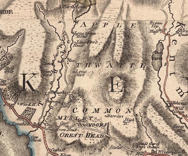 J5NY40SW.jpg "OREST HEAD" hill hachuring; hill or mountain item:- National Library of Scotland : EME.s.47 Image © National Library of Scotland |
|
|
|
||
| evidence:- | descriptive text:- West 1778 (11th edn 1821) placename:- Orrest Head |
|
| source data:- | Guide book, A Guide to the Lakes, by Thomas West, published by
William Pennington, Kendal, Cumbria once Westmorland, and in
London, 1778 to 1821. goto source goto sourceAddendum; Mr Gray's Journal, 1769 Page 213:- "... The way [road south from Ambleside] rises continually, till a place called Orrest-head where it turns south-east, losing sight of the water [Windermere]. ..." |
|
|
|
||
| evidence:- | old map:- Cary 1789 (edn 1805) placename:- Crest Head |
|
| source data:- | Map, uncoloured engraving, Westmoreland, scale about 2.5 miles
to 1 inch, by John Cary, London, 1789; edition 1805.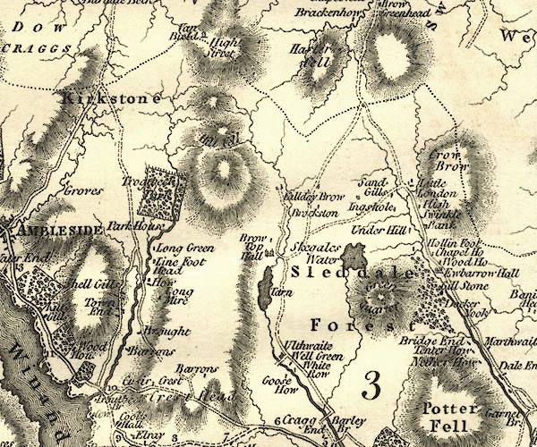 CY24NY40.jpg "Crest Head" hill hachuring item:- JandMN : 129 Image © see bottom of page |
|
|
|
||
| evidence:- | descriptive text:- Ford 1839 (3rd edn 1843) placename:- Orrest Head |
|
| source data:- | Guide book, A Description of Scenery in the Lake District, by
Rev William Ford, published by Charles Thurnam, Carlisle, by W
Edwards, 12 Ave Maria Lane, Charles Tilt, Fleet Street, William
Smith, 113 Fleet Street, London, by Currie and Bowman,
Newcastle, by Bancks and Co, Manchester, by Oliver and Boyd,
Edinburgh, and by Sinclair, Dumfries, 1839. goto source Page 160:- "..." "Orest Head is ornamented by several villas, and commands very noble views of Windermere." |
|
|
|
||
| evidence:- | old map:- Ford 1839 map placename:- Orrest Head |
|
| source data:- | Map, uncoloured engraving, Map of the Lake District of
Cumberland, Westmoreland and Lancashire, scale about 3.5 miles
to 1 inch, published by Charles Thurnam, Carlisle, and by R
Groombridge, 5 Paternoster Row, London, 3rd edn 1843.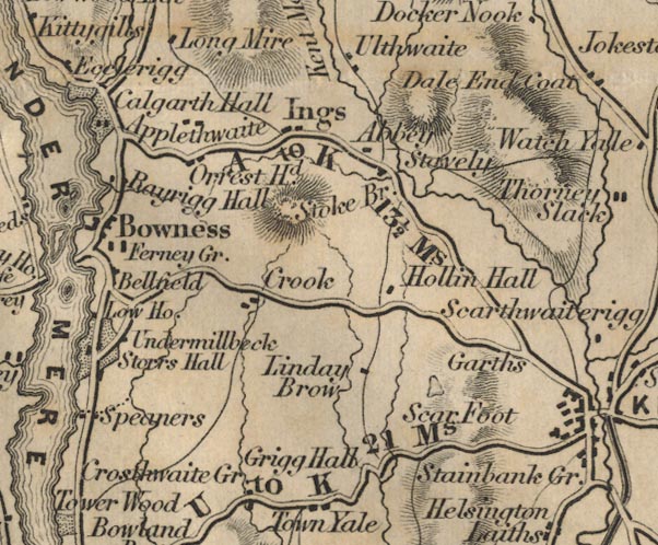 FD02SD49.jpg "Orrest Hd." Hill hachuring. item:- JandMN : 100.1 Image © see bottom of page |
|
|
|
||
| evidence:- | old print:- Pyne 1853 placename:- Orrest Head |
|
| source data:- | Print, chromolithograph, Windermere as seen from Orrest Head, Windermere, Westmorland,
by James Baker Pyne, engraved by W Gauci, published by Thomas Agnew and Sons, Manchester,
Lancashire, 1859.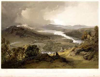 click to enlarge click to enlargePYN311.jpg "PAINTED BY J. B. PYNE. / L. HAGHE, LITH. / MANCHESTER, PUBLISHED BY THOMAS AGNEW & SONS. / Windermere as seen from Orrest Head / PRINTED BY DAY & SON, LITHRS. TO THE QUEEN" item:- Armitt Library : 2016.1944 Image © see bottom of page |
|
|
|
||
| evidence:- | old text:- Martineau 1855 item:- horse breaking |
|
| source data:- | Guide book, A Complete Guide to the English Lakes, by Harriet
Martineau, published by John Garnett, Windermere, Westmorland,
and by Whittaker and Co, London, 1855; published 1855-76. goto source Page 5:- "... When the traveller foot or horseback sees certain reaches of Lake Windermere from Orrest Head, lying deep down below him, he knows he is coming near the end of the railway, ... The old coach road over Orrest Head and the railway meet at the new village of Windermere, ..." "... Orrest Head, where" goto sourcePage 6:- "he will see a lovely view,- a picturesque cottage roof, surrounded by trees, in the foreground; grey rocks cropping out of the sward on the other side of the hedges; and in front, overlapping hills, range behind range, with the grey waters of the lake lying below. ..." |
|
|
|
||
| evidence:- | outline view:- Baddeley 1930s |
|
| source data:- | Print, lithograph, Panorama of Fells, etc, from Orrest Head, engraved by John Bartholomew
and Co, Edinburgh, published by Ward, Lock and Co, Warwick House, Salisbury Square,
London, 1930s.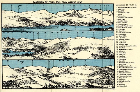 click to enlarge click to enlargeBE01E1.jpg item:- JandMN : 305.1 Image © see bottom of page |
|
|
|
||
| evidence:- | outline view:- Black 1856 (23rd edn 1900) placename:- Orrest Head |
|
| source data:- | Print, lithograph, Outline Views, Windermere - Mountains as seen from the North End
of Belle Isle, Windermere, and Mountains as seen from Biscay How, Bowness, by J Flintoft,
Keswick, Cumberland, engraved by R Mason, Edinburgh, Lothian, about 1900.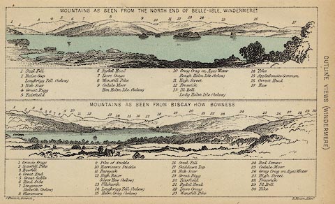 click to enlarge click to enlargeBC08E1.jpg "... 16 Orrest Head ..." item:- JandMN : 37.4 Image © see bottom of page |
|
|
|
||
| evidence:- | outline view:- Black 1841 (3rd edn 1846) placename:- Orrest Head |
|
| source data:- | Print, engraving, outline view, Mountains as seen from the North End of Belle Isle,
Windermere, and Mountains as seen from Bisket How, Bowness, by J Flintoft, Keswick,
Cumberland, engraved by R Mason, Edinburgh, about 1844.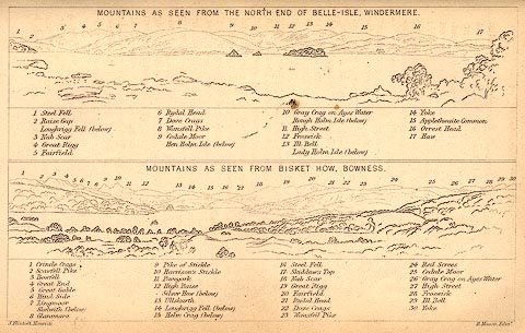 click to enlarge click to enlargeBC02E1.jpg "... 16 Orrest Head ..." item:- JandMN : 32.3 Image © see bottom of page |
|
|
|
||
Lakes Guides menu.