 Old Cumbria Gazetteer
 |
 |
|
||||||||||||||||||||||||||||||||||||||||||||||||||||||||||||||||||||||||||||||||||||||||||||||||||||||||||||||||
| road, Egremont to Carlisle | ||||||||||||||||||||||||||||||||||||||||||||||||||||||||||||||||||||||||||||||||||||||||||||||||||||||||||||||||||
| Egremont to Carlisle | ||||||||||||||||||||||||||||||||||||||||||||||||||||||||||||||||||||||||||||||||||||||||||||||||||||||||||||||||||
| Carlisle to Egremont | ||||||||||||||||||||||||||||||||||||||||||||||||||||||||||||||||||||||||||||||||||||||||||||||||||||||||||||||||||
| locality:- | Egremont | |||||||||||||||||||||||||||||||||||||||||||||||||||||||||||||||||||||||||||||||||||||||||||||||||||||||||||||||||
| civil parish:- | Egremont (formerly Cumberland) | |||||||||||||||||||||||||||||||||||||||||||||||||||||||||||||||||||||||||||||||||||||||||||||||||||||||||||||||||
| county:- | Cumbria | |||||||||||||||||||||||||||||||||||||||||||||||||||||||||||||||||||||||||||||||||||||||||||||||||||||||||||||||||
| locality type:- | route | |||||||||||||||||||||||||||||||||||||||||||||||||||||||||||||||||||||||||||||||||||||||||||||||||||||||||||||||||
| locality:- | Carlisle | |||||||||||||||||||||||||||||||||||||||||||||||||||||||||||||||||||||||||||||||||||||||||||||||||||||||||||||||||
| civil parish:- | Carlisle (formerly Cumberland) | |||||||||||||||||||||||||||||||||||||||||||||||||||||||||||||||||||||||||||||||||||||||||||||||||||||||||||||||||
| county:- | Cumbria | |||||||||||||||||||||||||||||||||||||||||||||||||||||||||||||||||||||||||||||||||||||||||||||||||||||||||||||||||
| locality type:- | route | |||||||||||||||||||||||||||||||||||||||||||||||||||||||||||||||||||||||||||||||||||||||||||||||||||||||||||||||||
|
|
||||||||||||||||||||||||||||||||||||||||||||||||||||||||||||||||||||||||||||||||||||||||||||||||||||||||||||||||||
| route parts:- |  Egremont to Cockermouth Cockermouth to Carlisle Egremont to Cockermouth Cockermouth to Carlisle |
|||||||||||||||||||||||||||||||||||||||||||||||||||||||||||||||||||||||||||||||||||||||||||||||||||||||||||||||||
|
|
||||||||||||||||||||||||||||||||||||||||||||||||||||||||||||||||||||||||||||||||||||||||||||||||||||||||||||||||||
| evidence:- | old road book:- Ogilby 1675 (edn 1698) |
|||||||||||||||||||||||||||||||||||||||||||||||||||||||||||||||||||||||||||||||||||||||||||||||||||||||||||||||||
| source data:- | OB16p045.txt page 45; describing plate 96 "The Road from" "..." "And from Egrimond to CARLISLE."
"Forward Turnings to be avoided." "..." "In the Road to CARLISLE." "At the End of Egrimond, the Left to Whithaven. 5'1 the Right acute. 6'1 the Right to Keswick. 7'3 the Right acute. 8'2 the Left acute. 15'3 the Left to Bridkirk. 16'6 The Right acute. 22'6 the Left to Blin-Rosset. 31'2 the Left acute." "In the Road to Carlisle." "FROM Egrimond, the Initial Borough-Town near the Sea, having the advantage of a strong castle, and of a good Market on Saturd. pass by Clint-Hill on the Left; cross 2 Brooks and come at 1'6 to Cleater-V. of 2 F. Then over some Hills, and by several Houses, leaving the Fells on the Right, and Winick-V. with Lampley-Hall on the same hand, at 7'5 ascend 3 F. and cross a Valley, where you a Lake on the Right; also at 9 M. Eglesfield-V. on the same hand; and at 10 M. Bridgham-V. on the Left: Thence a straight open Way leads by Coker flv. on the Right, at 14 M. to Cockermouth a Mt-Town as before." "Hence over a Hill at 16'2 follow'd by another, cross a large Valley; descend 1 M. at 20'2 and near the Bottom, come to Bowland-V. Then by Overgate, Strutland-Guard, Lawood-Nook on the Right, and Courtland-Guard on the Left, at 23 M. cross a Stone-Br. and Brook; leaving Adderskip, White-Hall and Thurlmillgate on the Left. Afterwards over a Hill, cross 5 Valleys, and Eln flv. by Bolton, Croshil and Gromhil Villages, and the Ruins of old Carlisle on the Left, and by the Red-Dial and Somer Villages on the Right." "At 30'4 over a Desc. cross a Brook, and at 31'6 leaving Warside-V. on the Left, and Roseley-Fell on the Right; go down a Hill: At the Bottom, over a Stone-Br. cross Wample flv. and by Croston-V. How-Hill and Turkin-Hill on the Left, at 33'3 enter Thuresby-V. of 3 F. Thence by Nealople and a Brook on the Left, a straight Way over a Moor, leads at 38'6 to the City of CARLISLE." "Backward Turnings to be avoided between CARLISLE and Egrimond." "I. 3 F. from Carlisle, the Right to Brook. II Thuresby the Left to Rosedel. III. At Lawood-Nook the Left to Torpenny. IV. 1 F. beyond Cleater, the Right acute." "Between Cockermouth and Kendal." "I. 3 F. from Cockermouth, the Left to Ireby. II. Against a part of Basinthwate, the Left acute. III. In Keswick, the Right to Burden. IV. 1 M. beyond Cust, the Left to St. John's." item:- private collection : 367 Image © see bottom of page |
|||||||||||||||||||||||||||||||||||||||||||||||||||||||||||||||||||||||||||||||||||||||||||||||||||||||||||||||||
|
|
||||||||||||||||||||||||||||||||||||||||||||||||||||||||||||||||||||||||||||||||||||||||||||||||||||||||||||||||||
| evidence:- | old map:- Ogilby 1675 (plate 96) |
|||||||||||||||||||||||||||||||||||||||||||||||||||||||||||||||||||||||||||||||||||||||||||||||||||||||||||||||||
| source data:- | Road strip map, hand coloured engraving, the Road from Kendal to
Cockermouth, and the Road from Egremond to Carlisle, scale about
1 inch to 1 mile, by John Ogilby, London, 1675.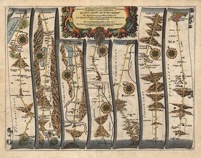 click to enlarge click to enlargeOG96.jpg "The Roads from EGREMONT to the City of CARLISLE in Cumberld." item:- JandMN : 22 Image © see bottom of page |
|||||||||||||||||||||||||||||||||||||||||||||||||||||||||||||||||||||||||||||||||||||||||||||||||||||||||||||||||
|
|
||||||||||||||||||||||||||||||||||||||||||||||||||||||||||||||||||||||||||||||||||||||||||||||||||||||||||||||||||
| evidence:- | old map:- Morden 1695 (EW) |
|||||||||||||||||||||||||||||||||||||||||||||||||||||||||||||||||||||||||||||||||||||||||||||||||||||||||||||||||
| source data:- | Map, hand coloured engraving, England, including Wales, scale
about 27 miles to 1 inch, by Robert Morden, published by Abel
Swale Awnsham and John Churchil, London, about 1695.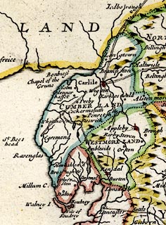 click to enlarge click to enlargeMRD3Cm.jpg double line; road item:- JandMN : 339 Image © see bottom of page |
|||||||||||||||||||||||||||||||||||||||||||||||||||||||||||||||||||||||||||||||||||||||||||||||||||||||||||||||||
|
|
||||||||||||||||||||||||||||||||||||||||||||||||||||||||||||||||||||||||||||||||||||||||||||||||||||||||||||||||||
| evidence:- | old text:- Ogilby 1699 (edn 1712) |
|||||||||||||||||||||||||||||||||||||||||||||||||||||||||||||||||||||||||||||||||||||||||||||||||||||||||||||||||
| source data:- | Road book, itineraries and map, The Traveller's Guide, by John
Ogilby, published by Abel Swall, Tim Child, White Hart, and R
Knaplock, the Angel and Crown, St Paul's Churchyard, London,
1699. OGY7p179.txt page 179 Distances from Egremont "In the Road to Carlisle." "FROM Egrimond, the initial Borough-Town near the Sea, having the advantage of a strong Castle, and of a good Market on Saturd. pass by Clint-hill on the Left; cross 2 Brooks, and come at 1'6 to Cleater V. of 2F. Then over some Hills, and by several Houses, leaving the Fells on the Right, and Winnick V. with Lampley-hall on the same hand, at 7'5 ascend 3F. and cross a Valley, where you have a Lake on the Right; also at 9M. Eglesfield V. on the same hand; and at 10M. Bridgham V. on the Left. Thence a strait open Way leads by Coker flv. on the Right, at 14M. to Cockermouth, a Mt. Town, as before." "Hence over a Hill at 16'2, follow'd by another, cross a large Valley, descend 1M. at 20'2, and near the Bottom, come to Bowland V. Then by Overgate, Strutland Guard, Lawood Nook, on the Right, and Courtland Guard on the Left, at 23 M. cross a Stone Br. and Brook; leaving Adderskip, White-hall and Thurlmillgate on the Left. Afterwards over a Hill, cross 5 Valleys, and Eln flv. by Bolton, Crosshil and Gromhil Villages, and the Ruins of old Carlisle on the Left, and by the Red Dial and Somer Villages on the Right." "At 30'4 over a Desc. cross a Brook, and at 31'6 leaving Warside V. on the Left, and Roseley-Fell on the Right; go down a Hill. At the Bottom, over a Stone Br. cross Wample flv. and by Croston V. How-hill and Turkin-hill on the Left, at 33'3 enter Thuresby V. of 3F. Thence by Nealople and a Brook on the Left, a strait Way over a Moor, leads at 38'6 to the City of CARLISLE." "Backwards Turnings to be avoided between CARLISLE and Egrimond." "I. 3F. from Carlisle, the Right to Brook. II. Thuresby, the Left to Rosedel. III. At Lawood-Nook, the Left to Torpenny. IV. 1F. beyond Cleater, the Right acute." "Between Cockermouth and Kendal." "I. 3F. from Cockermouth, the Left to Ireby. II. Against a part of Basinthwaite, the Left acute. III. In Keswick, the Right to Burden. IV. 1M. beyond Cust. the Left to St. John's." OGY7p251.txt page 250 "... And from Egrimond to CARLISLE in Cumberland. ..." page 251
|
|||||||||||||||||||||||||||||||||||||||||||||||||||||||||||||||||||||||||||||||||||||||||||||||||||||||||||||||||
|
|
||||||||||||||||||||||||||||||||||||||||||||||||||||||||||||||||||||||||||||||||||||||||||||||||||||||||||||||||||
| evidence:- | old strip map:- Senex 1719 (plate 96/Roads) |
|||||||||||||||||||||||||||||||||||||||||||||||||||||||||||||||||||||||||||||||||||||||||||||||||||||||||||||||||
| source data:- | Strip map, road map, The Road from Kendal in Westmorel to Cockermouth and The Road
from Egremond to Carlisle in Cumberland, by John Senex, The Globe, Salisbury Court,
Fleet Street, London, 1719.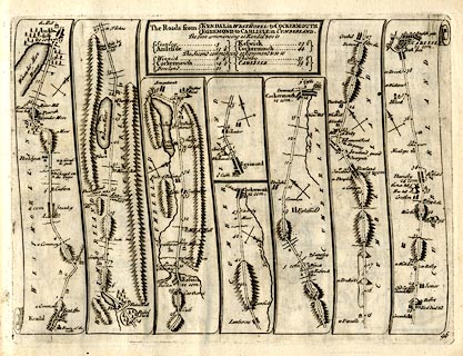 click to enlarge click to enlargeSEN5M5.jpg Plate 96 in An Actual Survey of all the Principal Roads of England and Wales. printed at plain cartouche, upper centre:- "The Roads from / KENDAL in WESTMOREL: to COCKERMOUTH / EGREMOND to CARLISLE in CUMBERLAND. / The first commencing at Kendal & so to / Stanley 5 / Amleside 13¼ / Keswick 29½ / Cockermouth 44 / The second commencing at Egremond & so to / Winnick 6¼ / Cockermouth 14¼ / Bowland 21 / Thursby 33¼ / CARLISLE 39¼" printed at bottom right:- "96" item:- private collection : 272.5 Image © see bottom of page |
|||||||||||||||||||||||||||||||||||||||||||||||||||||||||||||||||||||||||||||||||||||||||||||||||||||||||||||||||
|
|
||||||||||||||||||||||||||||||||||||||||||||||||||||||||||||||||||||||||||||||||||||||||||||||||||||||||||||||||||
| evidence:- | old map:- Bowen 1720 (plate 261) |
|||||||||||||||||||||||||||||||||||||||||||||||||||||||||||||||||||||||||||||||||||||||||||||||||||||||||||||||||
| source data:- | Road strip map, uncoloured engraving, pl.261, the end of the
road from Kendal to Cockermouth and the road from Egremont to
Carlisle, scale about 2 miles to 1 inch, published by Emanuel
Bowen, St Katherines, London, 1720.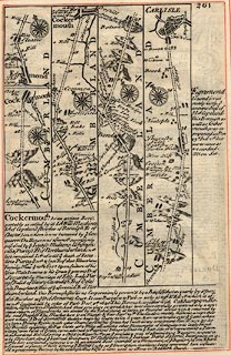 click to enlarge click to enlargeB261.jpg The road from Egremont to Carlisle. Places labelled are:- Egremond, The Castle / 1, Clint Hill / 2, Cleater / 3 ... 6 / Winnick on both sides? Lampley Hall on right / 7 .. 8 / 9, Eaglesfield on right / 10, Bridgham on left / 11 .. 13, Cocker Flu on right and a Water Mill / 14, Cockermouth, a Stone Br. over Darwent Flu / 15 .. 20 / 21, Bowland / Overgate on right / Strickland Guard on right / 22, Courtland Guard on left, Lawood Nook, an Inn / 23, a Watermill, a Stone Bridge / Adderskip on left / Whitehall on left / 24, Thurlmillgate on left / 25 ... 26 / Bolton, Eln Flu / 27, Croshill / Gromhil / 28 / 29, Old Carlisle demolisht, Somer on right / 30 ... 31 / Roseley Fell on right / 32, Warside on left, a Stone br. over wample Flu / Croston on left / How Hill on left / 33 / Turkin Hill on left / Thuresby vulgo Fearsby / 34 / Nealople on left / 35 ... 33 (sic =38) / CARLISLE, entering by Irish Gate, and English Gate to right item:- Dove Cottage : Lowther.36 Image © see bottom of page |
|||||||||||||||||||||||||||||||||||||||||||||||||||||||||||||||||||||||||||||||||||||||||||||||||||||||||||||||||
|
|
||||||||||||||||||||||||||||||||||||||||||||||||||||||||||||||||||||||||||||||||||||||||||||||||||||||||||||||||||
| evidence:- | old road book:- Morgan 1759 |
|||||||||||||||||||||||||||||||||||||||||||||||||||||||||||||||||||||||||||||||||||||||||||||||||||||||||||||||||
| source data:- | MG01p144.txt page 144; in the Cross Roads
item:- private collection : 368 Image © see bottom of page |
|||||||||||||||||||||||||||||||||||||||||||||||||||||||||||||||||||||||||||||||||||||||||||||||||||||||||||||||||
|
|
||||||||||||||||||||||||||||||||||||||||||||||||||||||||||||||||||||||||||||||||||||||||||||||||||||||||||||||||||
| evidence:- | old map:- Kitchin 1767 (plate 84) |
|||||||||||||||||||||||||||||||||||||||||||||||||||||||||||||||||||||||||||||||||||||||||||||||||||||||||||||||||
| source data:- | Road strip map, uncoloured engraving, The Road from Kendal to
Cockermouth, and The Road from Egremont to Carlisle, in
Kitchin's Post Chaise Companion, by Thomas Kitchin, published by
Robert Sayer, 53 Fleet Street, John Bowles, Cornhill, and
Carington Bowles, St Paul's Church Yard, London, 1767.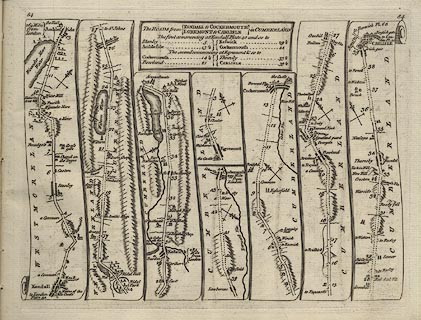 click to enlarge click to enlargeK084.jpg item:- Hampshire Museums : FA1999.138.84 Image © see bottom of page |
|||||||||||||||||||||||||||||||||||||||||||||||||||||||||||||||||||||||||||||||||||||||||||||||||||||||||||||||||
|
|
||||||||||||||||||||||||||||||||||||||||||||||||||||||||||||||||||||||||||||||||||||||||||||||||||||||||||||||||||
| evidence:- | old strip map:- Jeffery 1775 (pl.82/Roads) |
|||||||||||||||||||||||||||||||||||||||||||||||||||||||||||||||||||||||||||||||||||||||||||||||||||||||||||||||||
| source data:- | Strip map, road map, From Kendall to Cockermouth and From Egremont to Carlisle, by
Thomas Jefferys, published by R Sayer and J Bennett, 53 Fleet Street, London, 1775.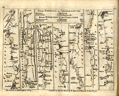 click to enlarge click to enlargeJEF6M5.jpg Plate 87 in Jefferys's Itinerary or Travellers Companion. printed at plain cartouche, upper centre:- "From KENDALL to COCKERMOUTH / Stanley 5 / Ambleside 13 / Keswick 29 / Cockermouth 44 / From EGREMONT to CARLISLE / Cockermouth 14 / Bowland 21 / Thursby 33½/ Carlisle 39" printed at top left and right:- "67 / 67" printed at bottom right of centre:- "Publish'd as the Acts directs by R. Sayer &I. Bennett 16 Janry. 1775." item:- private collection : 271.5 Image © see bottom of page |
|||||||||||||||||||||||||||||||||||||||||||||||||||||||||||||||||||||||||||||||||||||||||||||||||||||||||||||||||
|
|
||||||||||||||||||||||||||||||||||||||||||||||||||||||||||||||||||||||||||||||||||||||||||||||||||||||||||||||||||
 Lakes Guides menu.