 Old Cumbria Gazetteer
 |
 |
|
||||||||||||
| included in:- |
 road, Windermere to Penrith road, Ambleside to Penrith road, Windermere to Penrith road, Ambleside to Penrith |
|||||||||||||
| road, Kirkstone Pass to Patterdale | ||||||||||||||
| Kirkstone to Patterdale | ||||||||||||||
| Patterdale to Kirkstone | ||||||||||||||
| A592 | ||||||||||||||
| civil parish:- | Lakes (formerly Westmorland) | |||||||||||||
| civil parish:- | Patterdale (formerly Westmorland) | |||||||||||||
| county:- | Cumbria | |||||||||||||
| locality type:- | road route | |||||||||||||
| coordinates:- | ||||||||||||||
| 10Km square:- | NY40 | |||||||||||||
| 10Km square:- | NY41 | |||||||||||||
| 10Km square:- | NY31 | |||||||||||||
|
|
||||||||||||||
| evidence:- | old map:- Morden 1695 (Wmd) |
|||||||||||||
| source data:- | Map, hand coloured engraving, Westmorland, scale about 2.5 miles to 1 inch, by Robert
Morden, published by Abel Swale, the Unicorn, St Paul's Churchyard, Awnsham, and John
Churchill, the Black Swan, Paternoster Row, London, 1695.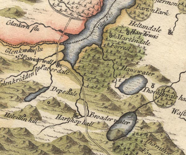 MD10NY41.jpg Double line. item:- JandMN : 24 Image © see bottom of page |
|||||||||||||
|
|
||||||||||||||
| evidence:- | old map:- Simpson 1746 map (Wmd) |
|||||||||||||
| source data:- | Map, uncoloured engraving, Westmorland, scale about 8 miles to 1
inch, printed by R Walker, Fleet Lane, London, 1746.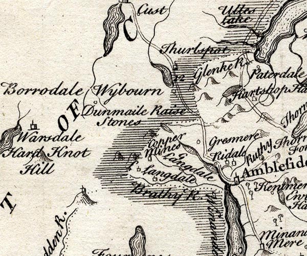 SMP2NYF.jpg 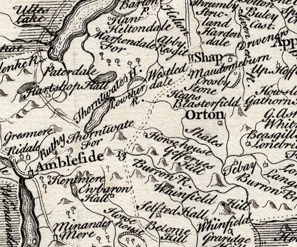 SMP2NYK.jpg Double line. item:- Dove Cottage : 2007.38.59 Image © see bottom of page |
|||||||||||||
|
|
||||||||||||||
| evidence:- | old map:- Bowen and Kitchin 1760 |
|||||||||||||
| source data:- | Map, hand coloured engraving, A New Map of the Counties of
Cumberland and Westmoreland Divided into their Respective Wards,
scale about 4 miles to 1 inch, by Emanuel Bowen and Thomas
Kitchin et al, published by T Bowles, Robert Sayer, and John
Bowles, London, 1760.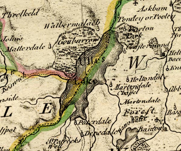 BO18NY31.jpg double line, solid and dotted 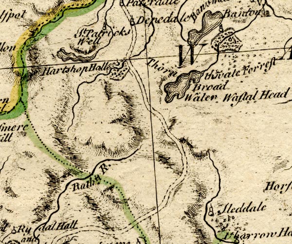 BO18NY30.jpg double line, dotted item:- Armitt Library : 2008.14.10 Image © see bottom of page |
|||||||||||||
|
|
||||||||||||||
| evidence:- | old map:- Jefferys 1770 (Wmd) |
|||||||||||||
| source data:- | Map, 4 sheets, The County of Westmoreland, scale 1 inch to 1
mile, surveyed 1768, and engraved and published by Thomas
Jefferys, London, 1770.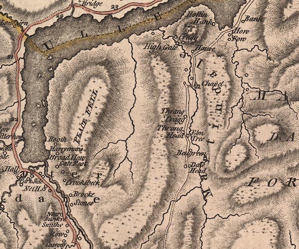 J5NY41NW.jpg 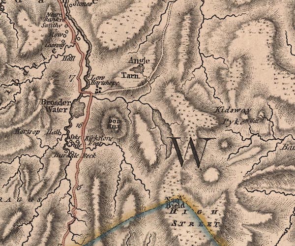 J5NY41SW.jpg 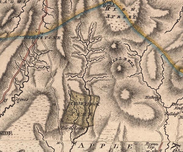 J5NY40NW.jpg double line; road, with mile numbers item:- National Library of Scotland : EME.s.47 Images © National Library of Scotland |
|||||||||||||
|
|
||||||||||||||
| evidence:- | descriptive text:- West 1778 (11th edn 1821) |
|||||||||||||
| source data:- | Guide book, A Guide to the Lakes, by Thomas West, published by
William Pennington, Kendal, Cumbria once Westmorland, and in
London, 1778 to 1821. goto source Page 162:- "Above Goldrill-bridge, the vale [Ullswater] bocomes (sic) narrow and poor, the mountains steep, naked, and rocky. Much blue slate, of an excellent kind, is excavated out of their bowels. The ascent from the lake to the top of Kirkston is easy, and there are many water-falls from the mountains on both sides. ..." |
|||||||||||||
|
|
||||||||||||||
| evidence:- | old map:- Crosthwaite 1783-94 (Ull) |
|||||||||||||
| source data:- | Map, uncoloured engraving, Accurate Map of the Beautiful Lake of
Ullswater, scale about 3 inches to 1 mile, by Peter Crosthwaite,
Keswick, Cumberland, 1783, version published 1800.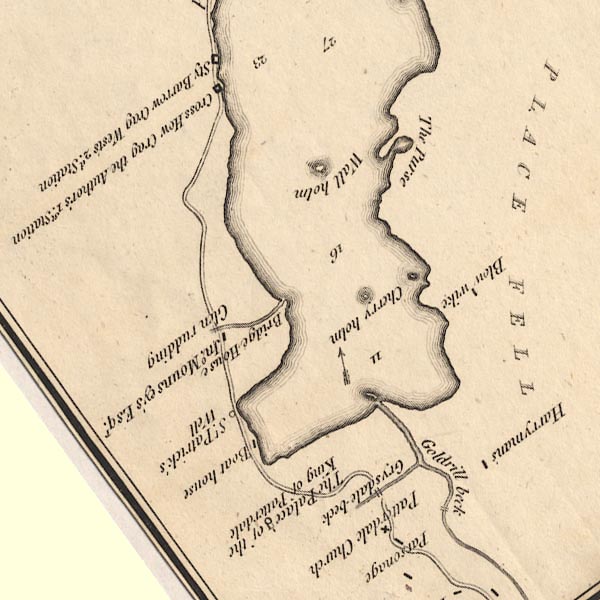 CT5NY31Y.jpg item:- Armitt Library : 1959.191.7 Image © see bottom of page |
|||||||||||||
|
|
||||||||||||||
| evidence:- | old text:- Clarke 1787 item:- echoes |
|||||||||||||
| source data:- | Guide book, A Survey of the Lakes of Cumberland, Westmorland,
and Lancashire, written and published by James Clarke, Penrith,
Cumberland, and in London etc, 1787; published 1787-93. goto source Page 153:- "... Having reached the top of Kirkstone, we again enter Patterdale; here is a curious view (of the bird's-eye kind,) down a Glen or Gulph of great depth, eight or nine miles. The road is down this Glen, very pleasant and good, between amazing high mountains, which strike the traveller with more awe than any he will as yet have seen; their sides are more perpendicular and rugged than any other I have seen of equal height, and under them we are obliged to travel, as both sides are alike. Here are rock upon rock, precipice above precipice, some fixed, others like to tumble down on each side of you; there is no where more than the breadth of the road between them, sometimes not so much, as it now and then takes the side of the mountains, accompanied by a rivulet which runs rapidly down its uneven bed, foaming and bounding from place to place ..." goto sourcePage 154:- "..." "The road from hence to Ulswater is pleasant and easy, through level meadows, adjoining to hanging woods and lofty mountains, down which are many tumbling waters; the winds drive the sound sometimes full upon the ear, at other times it is scarcely heard, unless re-echoed from the other side of you: you see one part of the mountain in a dark shade, another in the brightest colour the sun's oblique beams can give, and where snowy flocks in full view spot the verdure like pictures upon a wall. We now arrive at Ulswater, from whence we proceed to Penrith, through the tracts we amply described before." |
|||||||||||||
|
|
||||||||||||||
| evidence:- | old map:- Clarke 1787 map (Ullswater) |
|||||||||||||
| source data:- | Map, A Map of the Lake Ullswater and its Environs, scale about
6.5 ins to 1 mile, by James Clarke, engraved by S J Neele, 352
Strand, published by James Clarke, Penrith, Cumberland and in
London etc, 1787.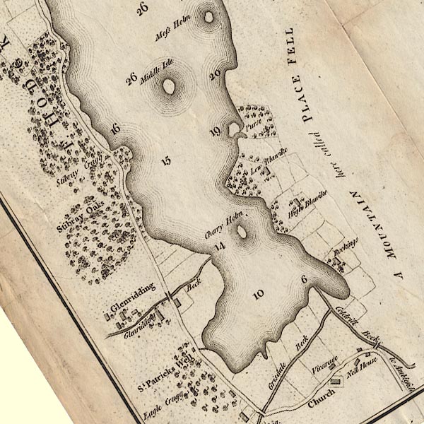 CL4NY31Y.jpg "to Ambleside" item:- private collection : 10.4 Image © see bottom of page |
|||||||||||||
|
|
||||||||||||||
| evidence:- | old print:- Green 1804 (plate 30) |
|||||||||||||
| source data:- | Print, uncoloured aquatint, Brother Water, descending from Kirkstone, Patterdale,
Westmorland, by William Green, Ambleside, Westmorland, 1804.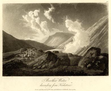 click to enlarge click to enlargeGN1630.jpg Plate 30 from a series. printed at bottom:- "Brother Water, / descending from Kirkstone. / Drawn and Engraved by Wm. Green, and Published at Ambleside, June 24, 1804." printed at top right:- "30" item:- Armitt Library : 2014.178 Image © see bottom of page |
|||||||||||||
|
|
||||||||||||||
| evidence:- | old text:- Green 1810 |
|||||||||||||
| source data:- | Set of prints, soft ground etchings, Sixty Studies from Nature,
by William Green, Ambleside, Westmorland, drawn 1808-10,
published 1810. goto source page 111:- "... from Brother Water to the inn at Patterdale the road is good, and winds pleasantly among trees, affording now and then a glimpse of the surrounding country." |
|||||||||||||
|
|
||||||||||||||
| evidence:- | old text:- Green 1814 |
|||||||||||||
| source data:- | Set of prints, soft ground etchings, Sixty Small Prints, with
text, A Description of a Series of Sixty Small Prints, by
William Green, Ambleside, Westmorland, 1814. goto source page 28:- "..." "The road from Ambleside to Ulls Water runs close to Brother Water, and the mountains rise from it on the right in a very bold style, ... At Brother Water the valley is scarcely half a mile across; and the western side of the lake is bounded by a hill, which rises steeply from it." "There is a road from Hartsope Hall to Ulls Water, which on the banks of Brother Water is through a wood of fine oaks, out of which the magnificent mountains of Hartsope rise in a style of superior grandeur." "..." "From Brother Water to the Inn at Patterdale the road is good, and winds pleasantly amongst trees, affording now and then a glimpse of the surrounding country." |
|||||||||||||
|
|
||||||||||||||
| evidence:- | old print:- Green 1815 item:- sheep; clouds |
|||||||||||||
| source data:- | Print, coloured aquatint, Brother Water, Patterdale, Westmorland, by William Green,
Ambleside, Westmorland, 1815.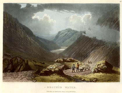 click to enlarge click to enlargeGN0517.jpg From the Kirkstone Pass. Plate 18 in Lake Scenery. printed at upper right:- "18" printed at bottom:- "BROTHER WATER. / Published at Ambleside, June 1, 1815, by Wm. Green." item:- Armitt Library : A6646.17 Image © see bottom of page |
|||||||||||||
|
|
||||||||||||||
| evidence:- | descriptive text:- Otley 1823 (5th edn 1834) item:- itinerary; road distances |
|||||||||||||
| source data:- | Guide book, A Concise Description of the English Lakes, the
mountains in their vicinity, and the roads by which they may be
visited, with remarks on the mineralogy and geology of the
district, by Jonathan Otley, published by the author, Keswick,
Cumberland now Cumbria, by J Richardson, London, and by Arthur
Foster, Kirkby Lonsdale, Cumbria, 1823; published 1823-49,
latterly as the Descriptive Guide to the English Lakes. goto source Page 106:- "AMBLESIDE TO ULLSWATER." "This is a very steep carriage road, rising 1300 feet above Ambleside, and falling 900 feet on the other side. This hill has taken its name of Kirkstone from a detached mass of rock, standing at a" goto sourcePage 107:- "little distance from the road, and bearing some resemblance to the form of a house. The road passes the small lake of Brothers' Water, and from thence leads through a narrow but pleasant valley to the inn at Patterdale. ..."
|
|||||||||||||
|
|
||||||||||||||
| evidence:- | old map:- Ford 1839 map |
|||||||||||||
| source data:- | Map, uncoloured engraving, Map of the Lake District of
Cumberland, Westmoreland and Lancashire, scale about 3.5 miles
to 1 inch, published by Charles Thurnam, Carlisle, and by R
Groombridge, 5 Paternoster Row, London, 3rd edn 1843.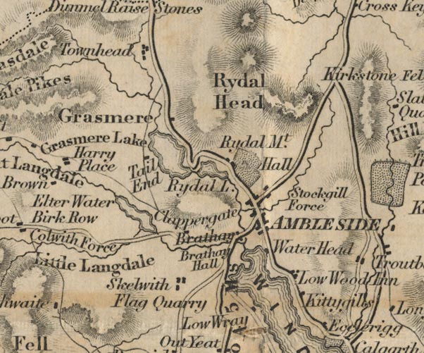 FD02NY30.jpg 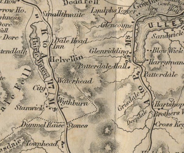 FD02NY31.jpg "A to P 25 Ms." Distance from Ambleside to Penrith. item:- JandMN : 100.1 Image © see bottom of page |
|||||||||||||
|
|
||||||||||||||
| evidence:- | old text:- Martineau 1855 |
|||||||||||||
| source data:- | Guide book, A Complete Guide to the English Lakes, by Harriet
Martineau, published by John Garnett, Windermere, Westmorland,
and by Whittaker and Co, London, 1855; published 1855-76. goto source Page 36:- "... There is something wilder to come, however,- the noted Kirkstone Pass,- the great pass of the district. The descent begins about a quarter of a mile beyond the house. Down" goto sourcePage 37:- "plunges the road, with rock and torrent on either hand, and the bold sweeps of Coldfield and Scandale Screes shutting in the pass; and the little lake of Brothers' Water lying below, afar off among the green levels; and, closing in the whole in front, the mass of Place Fell,- the other side of which goes sheer down into Ullswater. The stranger must not omit to observe near the head of the pass, the fallen rock, ridged like a roof, whose form (like that of a miniature church) has given its name to its precincts. All the way as he descends to Brothers' Water, the openings on the Scandale side (the left) charm his eye,- with their fissures, precipices, green slopes and levels, and knolls in the midst, crowned with firs. He passes through Hartsop, and then winds on, for three or four miles, among the rich levels of Patterdale, which is guarded by mountains jutting forwards, like promontories. ..." "..." goto sourcePage 41 (going back up):- "... at the top of the pass, (which he has walked up, in mercy to his horses) ..." |
|||||||||||||
|
|
||||||||||||||
| evidence:- | old photograph:- Bell 1880s-1940s |
|||||||||||||
| source data:- | Photograph, black and white, Kirkstone Pass, Patterdale, Westmorland, by Herbert Bell,
photographer, Ambleside, Westmorland, 1890s.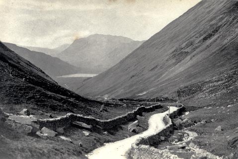 click to enlarge click to enlargeHB0625.jpg stamped on reverse:- "HERBERT BELL / Photographer / AMBLESIDE" item:- Armitt Library : ALPS286 Image © see bottom of page |
|||||||||||||
|
|
||||||||||||||
| evidence:- | old photograph:- Bell 1880s-1940s item:- motor car |
|||||||||||||
| source data:- | Photograph, crashed car, Kirkstone Pass, Patterdale, by Herbert Bell, Ambleside, Westmorland,
1900s?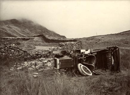 click to enlarge click to enlargeHB0236.jpg item:- Armitt Library : 1958.5093 Image © see bottom of page |
|||||||||||||
|
|
||||||||||||||
| evidence:- | gradient diagram:- Gall and Inglis 1890s-1900s (Roads) |
|||||||||||||
| source data:- | Contour Road Book of England, Northern Division, by Harry R G Inglis, published by
Gall and Inglis, 25 Paternoster Square, London and Edinburgh, 1898.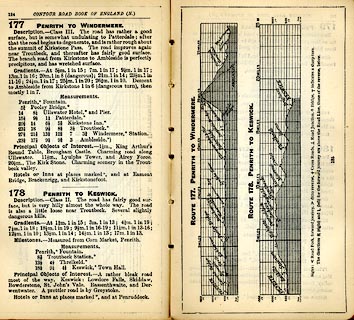 click to enlarge click to enlargeIG5177.jpg Itinerary, with gradient diagram, route 177, Penrith to Windermere, and route 178, Penrith to Keswick, Westmorland and Cumberland, 1898. item:- JandMN : 763.14 Image © see bottom of page |
|||||||||||||
|
|
||||||||||||||
| evidence:- | old print:- Bogg 1898 item:- stage coach; horse |
|||||||||||||
| source data:- | Print, engraving, A Mountain Road, Kirkstone, Patterdale, Westmorland, by Gilbert
Foster, published by Edmund Bogg, 3 Woodhouse Lane, and James Miles, Guildford Street,
Leeds, Yorkshire, 1898.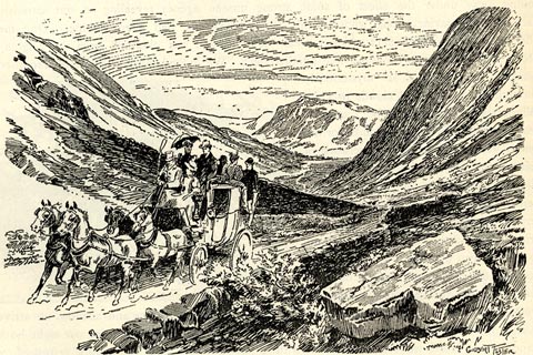 click to enlarge click to enlargeBGG132.jpg Included on p.126 of Lakeland and Ribblesdale, by Edmund Bogg. item:- JandMN : 231.32 Image © see bottom of page |
|||||||||||||
|
|
||||||||||||||
| places:- | Kirkstone Pass, Patterdale Patterdale |
|||||||||||||
|
|
||||||||||||||
Lakes Guides menu.