 Old Cumbria Gazetteer
 |
 |
|
||||||||||||||||||||||||||||||||||||||||||||||||||||||
| road, Carlisle to Tynemouth | ||||||||||||||||||||||||||||||||||||||||||||||||||||||||
| Carlisle to Tynemouth | ||||||||||||||||||||||||||||||||||||||||||||||||||||||||
| Tynemouth to Carlisle | ||||||||||||||||||||||||||||||||||||||||||||||||||||||||
| locality:- | Carlisle | |||||||||||||||||||||||||||||||||||||||||||||||||||||||
| civil parish:- | Carlisle (formerly Cumberland) | |||||||||||||||||||||||||||||||||||||||||||||||||||||||
| county:- | Cumbria | |||||||||||||||||||||||||||||||||||||||||||||||||||||||
| locality type:- | route | |||||||||||||||||||||||||||||||||||||||||||||||||||||||
| locality:- | Tynemouth | |||||||||||||||||||||||||||||||||||||||||||||||||||||||
| county:- | Northumberland | |||||||||||||||||||||||||||||||||||||||||||||||||||||||
| locality type:- | route | |||||||||||||||||||||||||||||||||||||||||||||||||||||||
|
|
||||||||||||||||||||||||||||||||||||||||||||||||||||||||
| route parts:- |  Carlisle to Brampton via Crosby Brampton to Haltwhistle Carlisle to Brampton via Crosby Brampton to Haltwhistle |
|||||||||||||||||||||||||||||||||||||||||||||||||||||||
|
|
||||||||||||||||||||||||||||||||||||||||||||||||||||||||
| route parts:- | Carlisle to Brampton via Warwick Brampton to Haltwhistle |
|||||||||||||||||||||||||||||||||||||||||||||||||||||||
|
|
||||||||||||||||||||||||||||||||||||||||||||||||||||||||
| evidence:- | old road book:- Ogilby 1675 (edn 1698) |
|||||||||||||||||||||||||||||||||||||||||||||||||||||||
| source data:- | OB16p040.txt page 40; describing plate 86 "The Road from" "TINMOUTH Com. Northumb. to CARLISLE, In Cumberland." "I. THE Point of Bearing W. II. The Direct Horizontal Distance 59 M." "III. The Vulgar Computation 50 M. IV. The Dimensuration 69'5."
"Forward Turnings to be avoided." "At the End of Tinmouth, the Left to Shields. 7 F. the Right acute. 3'6 the Right acute. 13 M. The Right to Denton. 22'1 The Left to Biwel. 31 M. The Right to Butsworth, and Carilsle; a different Way. 41'5 Beyond Mellis, the Right to Narford. 46'2 the Right in Haltwesel to Branton. 51'7 The Right and Left acute. 64'6 The Left acute. 66'7 The Left to Codby. 67'6 The Left to Botcherby." "FROM Tinmouth, cross a Brook at 6 F. by N. and S-Shields on the Left, and the Church on the Right: At 2'1 by Chillington-V. on the Left, and 3 F. farther, by Chirtons-V. on the Right, descend a Hill of 3 F. and by some Houses, go over a Valley at 4'4. Then by Pikewell-Hall on the Left; and at 7 M. by Biker-V. on the same Hand, cross a large Valley, thro' Useburn-V. and at 8'6 enter New-Castle or New-Castle upon Tine, a large Corp. Mt. and Shire-Town." "Thence over a Hill of 4 F. and a large Valley, pass by Denton-Hall on the Right, and near the Top of the Hill, W-Denton-V. on the Left. On the Top, thro' Pigshal-V, descend a Hill of 8 F. and at the Bottom, pass thro' Newborn-V. of 2 F. having the Tine on the Left, and Righton-Ch. on the other side of it. At 16'7 crossing a Wood-Br. and Brook, and over a Hill, go thro' Wilam-V. in a Vale. Then descend another Hill, and cross a Stone-Br. and Brook." "At 20'7 Prudhor-Castle appears on the Left, Tine flv. passing between it and the R. About 3 F. farther, pass thro' Ovingham-V. of 2 F. and at the End of it, cross a Stone-Br. and Brook: At 22'2 on a Hill of 9 F. go thro' Ovington-V. and at 24'4 cross a valley and leave Newton-Ch. on the Right. Over another Vale, come at 27 M. to a Desc. of 7 F. and thro' Gorebridg alias Cerbridg-V. of 2 F. Thence by a Water-Mill on the Right (where part of the Tine flv. runs in the Road) and by Sandy-V. on the same Hand, pass at 29 M. to Bestrick a small Village." "Hence by Anwick-Grange and Anwick on the Hill, both on the Right, come at 31'1 to Tine flv. which you pass over, and 3 F. farther, to Hexam or Hexham, of above 3 F. call'd Hangustald by Beda, Alexodunum by the Romans, and Hagulstaldesham by M. Sommer; a Town of great account in former Time, being dignify'd with an Episcopal Sea: The Cathedral was a most stately Structure, built by St. Wilfred, and Possess'd by 10 Bishops successively, but being spoil'd by the Danes, the See was remov'd to York. 'Tis at present a well-built Bailiwick Town on the Tine, and has an indifferent Mt. for Corn, &c. on Tuesd. 'Twas formerly famous for its Abbey and Church; one of which is now decay'd, and a great part of the other was pull'd down by the Scots." "Leaving Hexham, ascend a Hill of 10 F. to a Moor, and traverse 2 Valleys. In the latter, over Hadon-Br. cross South-Tine flv. and pass thro' Hadon, leaving the Ch. on the Right: Then by Sapwood-V. on the Right, also over 3 Valleys; at 41 M. descend 5 F. and go thro' Mellis-V. At 42'5 thro' Slow-House-V. leave Woodhil-V. on the Left, and set forward thro' Milcriche at 44'4. At 45'2 ascending, cross 2 Valleys, to Haltwesel of 5 F. a Town indifferent well-built, and affording good Entertainment: At 48'2 pass thro' Redbath-V. and leave Hole-house on the Left." "Thence thro' a Wood, and by Blenkensop-Castle on the Right, also by Goomholt-V. at 50'3 Thirlwal-Castle at 50'6 Longbuyer-Castle at 51 M. and Furley-V. at 51'3 all successively on the same Hand. Then by Belton and Crook 2 Villages on the Left, come at 52'2 over Poltrose flv. to Cumberland. There ascend a Hill of 5 F. and touch upon a part of the Picts Wall on the Right. Thence by Dearington-V. close on the Right, pass thro' a Copse, also thro' Chappelbourn-V. at 54'6, and cross a large Valley. At 58'7 descend a Hill, and over a Wooden-Br. and Brook, leave Milton-V. somewhat on the Right." "At 60'2 ascend 4 F. and presently descend 1 M. where a Park ranges along the Road on the Right. Whence crossing several Brooks come at 64'2 to Corbey-V. of 3 F. beyond which, cross Warwick-Stone-Br. over Eden flu. and ascending a Hill, pass thro' Warwick, a small Village: Then leaving Eglionbury-V. on the Right; thro' Wheelborough-Hall-V. at 56'6, and over Petterel flv. at 68'1 fall in with the Road from London, and arrive at Bother-street, a Suburb of CARLISLE at 68'7, 4 F. farther, entering the City it self; a Place of great Antiquity and Strength, fortify'd with a Castle," "Wall" page 41 "Wall and Bulwarks: 'Tis well-built, well Water'd, and much resorted to, by reason of its nearness to Scotland; enjoying ample Immunities and Privileges." "Backward Turnings to be avoided." "I. 2 F. from Carlisle, the Right to Penrith, Lancaster, &c. II. 2 F. short of Stow-House, the Left to Narford. III. 7 F. beyond Hadon-Br. the Left acute. IV. 1'5 Short of Chillington, the Right to Shields." item:- private collection : 367 Image © see bottom of page |
|||||||||||||||||||||||||||||||||||||||||||||||||||||||
|
|
||||||||||||||||||||||||||||||||||||||||||||||||||||||||
| evidence:- | old map:- Ogilby 1675 |
|||||||||||||||||||||||||||||||||||||||||||||||||||||||
| source data:- | Road strip map, uncoloured engraving, the Road from Tinmouth ...
to Carlisle, scale about 1 inch to 1 mile, by John Ogilby,
London, 1675.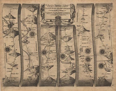 click to enlarge click to enlargeOG86.jpg item:- JandMN : 73 Image © see bottom of page |
|||||||||||||||||||||||||||||||||||||||||||||||||||||||
|
|
||||||||||||||||||||||||||||||||||||||||||||||||||||||||
| evidence:- | old map:- Berry 1679 |
|||||||||||||||||||||||||||||||||||||||||||||||||||||||
| source data:- | Road map, diagram, The Grand Roads of England, engraved by John
Rich, made and published by William Berry, at the Sign of the
Globe, London, 1679. from the east, Newcastle through Haltshessel, Northumberland; 6 miles to Chapelborn 7 Corby 4 CARLILE, Cumberland |
|||||||||||||||||||||||||||||||||||||||||||||||||||||||
|
|
||||||||||||||||||||||||||||||||||||||||||||||||||||||||
| evidence:- | old map:- Morden 1695 (EW) |
|||||||||||||||||||||||||||||||||||||||||||||||||||||||
| source data:- | Map, hand coloured engraving, England, including Wales, scale
about 27 miles to 1 inch, by Robert Morden, published by Abel
Swale Awnsham and John Churchil, London, about 1695. click to enlarge click to enlargeMRD3Cm.jpg double line; road item:- JandMN : 339 Image © see bottom of page |
|||||||||||||||||||||||||||||||||||||||||||||||||||||||
|
|
||||||||||||||||||||||||||||||||||||||||||||||||||||||||
| evidence:- | old strip map:- Senex 1719 (plate 86/Roads) |
|||||||||||||||||||||||||||||||||||||||||||||||||||||||
| source data:- | Strip map, road map, The Road from Tinmouth to Carlisle, including from Haltwhistle,
Northumberland; through Brampton, to Carlisle, Cumberland, by John Senex, The Globe,
Salisbury Court, Fleet Street, London, 1719.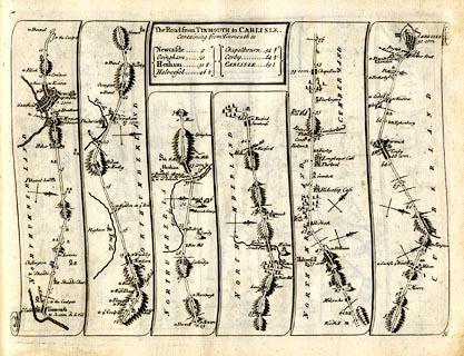 click to enlarge click to enlargeSEN5M4.jpg Plate 86 in An Actual Survey of all the Principal Roads of England and Wales. printed at plain cartouche, upper centre:- "The Road from TINMOUTH to CARLISLE. / Containing from Tinmouth to / Newcastle 9 / Ovingham 21 / Hexham 31½ / Haltwesel 46½ / Chapelbourn 542/3 / Corby 64½ / CARLISLE 69½" printed at bottom right:- "86" item:- private collection : 272.4 Image © see bottom of page |
|||||||||||||||||||||||||||||||||||||||||||||||||||||||
|
|
||||||||||||||||||||||||||||||||||||||||||||||||||||||||
| evidence:- | old map, descriptive text:- Bowen 1720 (plate 232) |
|||||||||||||||||||||||||||||||||||||||||||||||||||||||
| source data:- | Road strip map, road map, pl.232, part of The Road from Tinmouth
to Carlisle, scale about 2 miles to 1 inch, with sections in
Northumberland and Cumberland, published by Emanuel Bowen, St
Katherines, London, 1720.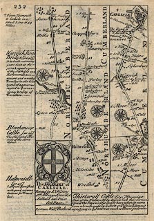 click to enlarge click to enlargeB232.jpg item:- JandMN : 65.232 Image © see bottom of page |
|||||||||||||||||||||||||||||||||||||||||||||||||||||||
|
|
||||||||||||||||||||||||||||||||||||||||||||||||||||||||
| evidence:- | old road book:- Morgan 1759 |
|||||||||||||||||||||||||||||||||||||||||||||||||||||||
| source data:- | MG01p167.txt page 167 and 168; in the Cross Roads
Image © see bottom of page |
|||||||||||||||||||||||||||||||||||||||||||||||||||||||
|
|
||||||||||||||||||||||||||||||||||||||||||||||||||||||||
| evidence:- | old map:- Kitchin 1767 (plate 97) |
|||||||||||||||||||||||||||||||||||||||||||||||||||||||
| source data:- | Road strip map, uncoloured engraving, The Road from Tinmouth to
Carlisle, in Kitchin's Post Chaise Companion, by Thomas Kitchin,
published by Robert Sayer, 53 Fleet Street, John Bowles,
Cornhill, and Carington Bowles, St Paul's Church Yard, London,
1767.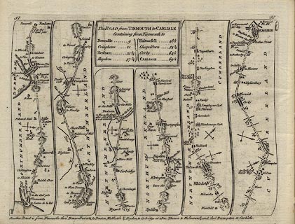 click to enlarge click to enlargeK097.jpg item:- Hampshire Museums : FA1999.138.97 Image © see bottom of page |
|||||||||||||||||||||||||||||||||||||||||||||||||||||||
|
|
||||||||||||||||||||||||||||||||||||||||||||||||||||||||
| evidence:- | old strip map:- Jeffery 1775 (pl.95/Roads) |
|||||||||||||||||||||||||||||||||||||||||||||||||||||||
| source data:- | Strip map, road map, From Tinmouth to Carlisle, by Thomas Jefferys, published by R
Sayer and J Bennett, 53 Fleet Street, London, 1775.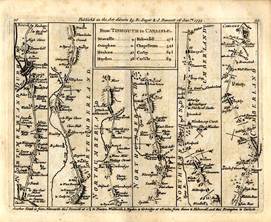 click to enlarge click to enlargeJEF6M6.jpg Plate 95 in Jefferys's Itinerary or Travellers Companion. printed at plain cartouche, upper centre:- "From TINMOUTH to CARLISLE. / Newcastle 9 / Ovingham 21 / Hexham 32 / Haydon 38 / Haltwesell 47½ / Chapelburn 54½ / Corby 64½/ Carlisle 69" printed at top:- "95 / Publish'd as the Acts directs by R. Sayer &I. Bennett 16 Janry. 1775. / 95" item:- private collection : 271.6 Image © see bottom of page |
|||||||||||||||||||||||||||||||||||||||||||||||||||||||
|
|
||||||||||||||||||||||||||||||||||||||||||||||||||||||||
| evidence:- | old map:- Laurie and Whittle 1806 |
|||||||||||||||||||||||||||||||||||||||||||||||||||||||
| source data:- | Road map, Continuation of the Roads to Glasgow and Edinburgh,
scale about 10 miles to 1 inch, by Nathaniel Coltman? 1806,
published by Robert H Laurie, 53 Fleet Street, London, 1834. click to enlarge click to enlargeLw21.jpg "Carlisle to Newcastle 56 m." dotted line; 'Cross Roads' item:- private collection : 18.21 Image © see bottom of page |
|||||||||||||||||||||||||||||||||||||||||||||||||||||||
|
|
||||||||||||||||||||||||||||||||||||||||||||||||||||||||
| evidence:- | old text:- Gents Mag item:- vandalism |
|||||||||||||||||||||||||||||||||||||||||||||||||||||||
| source data:- | Magazine, The Gentleman's Magazine or Monthly Intelligencer or
Historical Chronicle, published by Edward Cave under the
pseudonym Sylvanus Urban, and by other publishers, London,
monthly from 1731 to 1922. goto source goto sourceGentleman's Magazine 1851 part 2 p.385 "..." "... He [the tourist] must first be apprised that for nineteen miles the wall has been levelled by order of the Government to form a high road, and that, for this extent, with some few exceptions caused by the obstructions of farm-houses, hills, and other impediments, the modern road is constructed upon the foundations of the wall. Walking in the centre of the road he may detect the facing stones of the Roman structure on his right and left. This great legalised piece of vandalism throws into the shade a century of petty pilferings and almost makes venial a thousand acts of destruction perpetuated by ignorant individuals. It is in this district where" |
|||||||||||||||||||||||||||||||||||||||||||||||||||||||
|
|
||||||||||||||||||||||||||||||||||||||||||||||||||||||||
| evidence:- | old text:- Gents Mag 1851 |
|||||||||||||||||||||||||||||||||||||||||||||||||||||||
| source data:- | goto source Gentleman's Magazine 1851 part 2 p.386 "the wall has been so effectually pulled down that Mr. Bruce's volume is particularly useful, enabling the traveller to recognize the sites of stations which he must else necessarily pass by without noticing, for they are now either covered with the greensward or with the annual produce of the husbandman. ..." "... At East Denton, a little beyond Benwell, the first glimpse of a fragment of the wall is to be seen on the left of the road. This and a few more similar vestiges have been preserved, owing to some insurmountable obstructions having caused the engineers of the Government road to swerve a little from the straight line. All along the course of the wall the" |
|||||||||||||||||||||||||||||||||||||||||||||||||||||||
|
|
||||||||||||||||||||||||||||||||||||||||||||||||||||||||
| evidence:- | gradient diagram:- Pratt 1905 (edn 1915) |
|||||||||||||||||||||||||||||||||||||||||||||||||||||||
| source data:- | Gradient diagram, Newcastle to Carlisle, in Pratt's Road Atlas of England and Wales
... by George Philip and Son, 32 Fleet Street, London, 1905, published by Anglo-American
Oil Co, 36-38 Queen Anne's Gate, Westminster, London, 1915.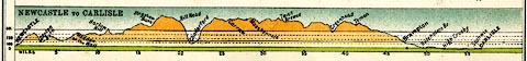 click to enlarge click to enlargePRA1G3.jpg "NEWCASTLE to CARLISLE" item:- Hampshire Museums : FA2001.138 Image © see bottom of page |
|||||||||||||||||||||||||||||||||||||||||||||||||||||||
|
|
||||||||||||||||||||||||||||||||||||||||||||||||||||||||
| evidence:- | old strip map:- Geographia 1925 |
|||||||||||||||||||||||||||||||||||||||||||||||||||||||
| source data:- | Road book, with road strip maps and gradient diagrams, Premier Road Book of Great
Britain, by Alexander Gross and F Waite-Browne, published by Geographia, 55 Fleet
Street, London, about 1925?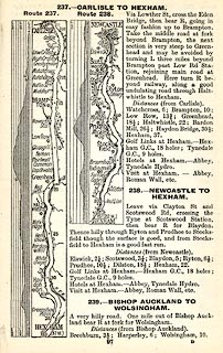 click to enlarge click to enlargeGE1097.jpg "237. - CARLISLE TO HEXHAM." "238. - NEWCASTLE TO HEXHAM." 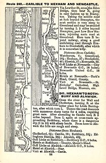 click to enlarge click to enlargeGE1098.jpg "Route 240. - CARLISLE TO HEXHAM AND NEWCASTLE." item:- Hampshire Museums : B1990.161.4 Image © see bottom of page |
|||||||||||||||||||||||||||||||||||||||||||||||||||||||
|
|
||||||||||||||||||||||||||||||||||||||||||||||||||||||||
Lakes Guides menu.