 Old Cumbria Gazetteer
 |
 |
|
|
| road, through Matterdale | |||
| Matterdale road | |||
| A5091 | |||
| civil parish:- | Hutton (formerly Cumberland) | ||
| civil parish:- | Matterdale (formerly Cumberland) | ||
| county:- | Cumbria | ||
| locality type:- | route | ||
| 10Km square:- | NY32 | ||
|
|
|||
| evidence:- | old map:- Crosthwaite 1783-94 (Ull) |
||
| source data:- | Map, uncoloured engraving, Accurate Map of the Beautiful Lake of
Ullswater, scale about 3 inches to 1 mile, by Peter Crosthwaite,
Keswick, Cumberland, 1783, version published 1800.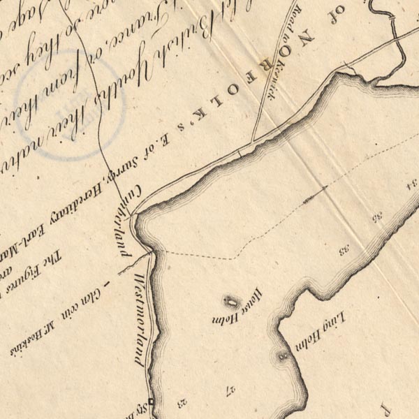 CT5NY31Z.jpg "Road to Keswick" item:- Armitt Library : 1959.191.7 Image © see bottom of page |
||
|
|
|||
| evidence:- | old map:- Clarke 1787 map (Ullswater) |
||
| source data:- | Map, A Map of the Lake Ullswater and its Environs, scale about
6.5 ins to 1 mile, by James Clarke, engraved by S J Neele, 352
Strand, published by James Clarke, Penrith, Cumberland and in
London etc, 1787.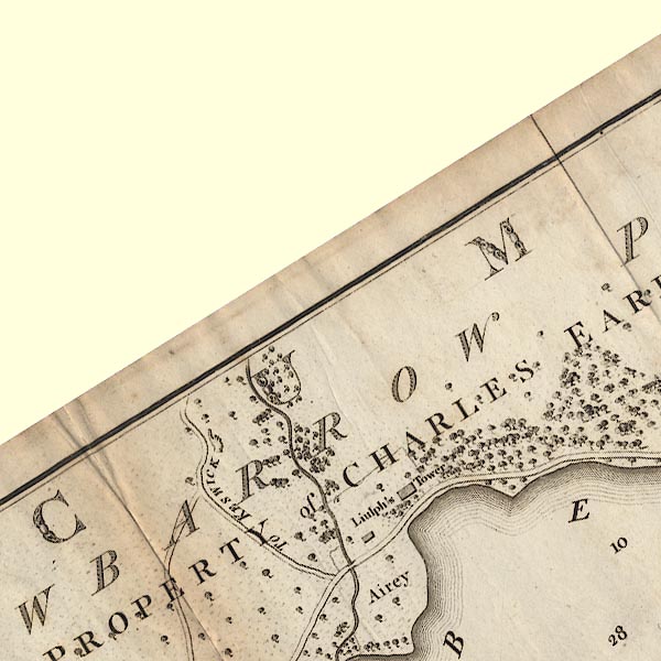 CL4NY32V.jpg "TO KESWICK" A hand points the way. item:- private collection : 10.4 Image © see bottom of page |
||
|
|
|||
| evidence:- | descriptive text:- Otley 1823 (5th edn 1834) |
||
| source data:- | Guide book, A Concise Description of the English Lakes, the
mountains in their vicinity, and the roads by which they may be
visited, with remarks on the mineralogy and geology of the
district, by Jonathan Otley, published by the author, Keswick,
Cumberland now Cumbria, by J Richardson, London, and by Arthur
Foster, Kirkby Lonsdale, Cumbria, 1823; published 1823-49,
latterly as the Descriptive Guide to the English Lakes. goto source goto sourcePage 136:- "Ullswater may be visited from Keswick on horseback or on foot; leaving the Penrith road a little beyond the second mile-stone, crossing the vale of Wanthwaite, and passing over a bleak mountain side to Matterdale. Carriages are obliged to continue on the turnpike road to Beckses, eleven miles; but a new road is in progress of making on the" goto sourcePage 137:- "western side of Mell Fell, which will shorten the distance nearly two miles. ..." |
||
|
|
|||
| evidence:- | perhaps gradient diagram:- Gall and Inglis 1890s-1900s (Roads) |
||
| source data:- | Contour Road Book of England, Northern Division, by Harry R G Inglis, published by
Gall and Inglis, 25 Paternoster Square, London and Edinburgh, 1898.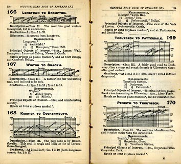 click to enlarge click to enlargeIG5166.jpg Itinerary, with gradient diagram, routes 166, Longtown to Brampton, 167, Wigton to Silloth, 168, Keswick to Cockermouth, 169, Troutbeck to Patterdale, and 170, Penrith to Troutbeck, Cumberland, 1898. item:- JandMN : 763.11 Image © see bottom of page |
||
|
|
|||
| evidence:- | old strip map:- CTC 1911 (Roads) |
||
| source data:- | Page 112 of Cyclists' Touring Club British Road Book new series vol.6, edited by F
B Sandford, published by Thomas Nelson and Sons, London etc, 1911.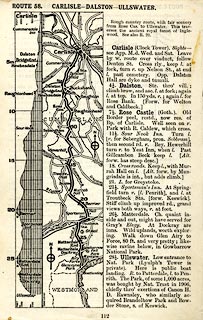 click to enlarge click to enlargeCTC2B2.jpg Strip road map, route 58, Carlisle Dalston Ullswater, scale roughly 5 miles to 1 inch. Together with an itinerary and gradient diagram. item:- JandMN : 491.112 Image © see bottom of page |
||
|
|
|||
| mapping:- | Matterdale |
||
|
|
|||
Lakes Guides menu.