 Old Cumbria Gazetteer
 |
 |
|
| roman road 82b, Cumbria | ||
| roman road 82 | ||
| locality:- | Bowes | |
| county:- | Northumberland | |
| locality type:- | roman road | |
| locality type:- | road | |
| civil parish:- | Brough (formerly Westmorland) | |
| county:- | Cumbria | |
| locality type:- | roman road | |
| locality type:- | road | |
|
|
||
| evidence:- | old map:- Stukeley 1723 |
|
| source data:- | Road map, uncoloured engraving, the Antonine Itineraries through
Britain, scale about 55 miles to 1 inch, plotted by William
Stukeley, 1723, published London, 1724.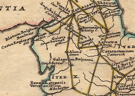 click to enlarge click to enlargeStu1Cm.jpg item:- Hampshire Museums : FA2001.171 Image © see bottom of page |
|
|
|
||
| evidence:- | old text:- Pennant 1773 |
|
| source data:- | Book, A Tour from Downing to Alston Moor, 1773, by Thomas
Pennant, published by Edward Harding, 98 Pall Mall, London, 1801. goto source goto sourcePennant's Tour 1773, page 138 "I traversed Sandford-heath, over which runs the Roman road, which is continued through the county from Brougham by Verterae, thence by Stanmore, and Maiden-castle, a small Roman fort, and again by Rerecross, where there is another small fort, near which it enters Yorkshire, pointing in a line to the station near Greata-bridge. ..." |
|
|
|
||
Lakes Guides menu.