 Old Cumbria Gazetteer
 |
 |
|
| roman road 82c, Cumbria | ||
| roman road 82 | ||
| civil parish:- | Brough (formerly Westmorland) | |
| civil parish:- | Brougham (formerly Westmorland) | |
| county:- | Cumbria | |
| locality type:- | roman road | |
| locality type:- | road | |
|
|
||
| evidence:- | perhaps old map:- Stukeley 1723 |
|
| source data:- | Road map, uncoloured engraving, the Antonine Itineraries through
Britain, scale about 55 miles to 1 inch, plotted by William
Stukeley, 1723, published London, 1724.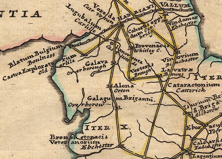 click to enlarge click to enlargeStu1Cm.jpg item:- Hampshire Museums : FA2001.171 Image © see bottom of page |
|
|
|
||
| evidence:- | descriptive text:- Defoe 1724-26 placename:- |
|
| source data:- | Tour through England and Wales, by Daniel Defoe, published in
parts, London, 1724-26. "The Roman highway, which I have so often mentioned, and which, in my last letter, I left at Leeming Lane and Peers Brigg, in the North Riding of York, enters this county from Rear Cross upon Stanmore, and crossing it almost due east and west, goes through Appleby, passing the Eden a little north from Perith, at an antient Roman station call'd Brovoniacum," "..." "Here [Carlisle] also the great Roman highway, ... has its end, this being the utmost station of the Roman soldiers on this side." |
|
|
|
||
| evidence:- | old text:- Pennant 1773 |
|
| source data:- | Book, A Tour from Downing to Alston Moor, 1773, by Thomas
Pennant, published by Edward Harding, 98 Pall Mall, London, 1801. goto source goto sourcePennant's Tour 1773, page 138 "I traversed Sandford-heath, over which runs the Roman road, which is continued through the county from Brougham ..." |
|
|
|
||
| evidence:- | old text:- Camden 1789 (Gough Additions) |
|
| source data:- | Book, Britannia, or A Chorographical Description of the Flourishing Kingdoms of England,
Scotland, and Ireland, by William Camden, 1586, translated from the 1607 Latin edition
by Richard Gough, published London, 1789. goto source Page 151:- "The great Roman road passed through this county from Stanemore to Brougham castle, and till the turnpike road was made it was very conspicuous almost the whole length of its course, six yards broad, formed of three courses of large square stones, (the lowermost largest) or of gravel and flint as materials varied. ..." |
|
|
|
||
| evidence:- | old text:- Camden 1789 (Gough Additions) placename:- Maiden Way |
|
| source data:- | Book, Britannia, or A Chorographical Description of the Flourishing Kingdoms of England,
Scotland, and Ireland, by William Camden, 1586, translated from the 1607 Latin edition
by Richard Gough, published London, 1789. goto source Page 159:- "..." "The Roman road called the Maiden way passes through a large camp, where the stone of king Marius formerly stood, now succeeded by the Rere cross. Thence through Maiden castle, a small square fort, in which have been found Roman mortars, quite through Market Brough, over Brough fair hill, ... Leaving on the left Warcop, a pretty village ... it passes along Sandford moor, and down a horse course to Cowpland beck bridge, where on the right are the ruined foundations of a noble round tower 40 paces diameter, ... Then by Appleby to the camp on Crackenthorp moor, through the end of Kirkby Thore downs, and through Temple Sowerby, a village of the Dalstons of Acorn bank. Then by the side of Whinfield forest to Hart-horn tree, ..." goto sourcePage 160:- "..." "... From hence the road goes due west to the Countess pillar, ..." "From hence the road carries us to Brougham castle, to Lowther bridge, and so over Emot into Cumberland." |
|
|
|
||
Lakes Guides menu.