 Old Cumbria Gazetteer
 |
 |
|
| Rosehill, Moresby | ||
| Rosehill | ||
| civil parish:- | Moresby (formerly Cumberland) | |
| county:- | Cumbria | |
| locality type:- | buildings | |
| coordinates:- | NX99092029 | |
| 1Km square:- | NX9920 | |
| 10Km square:- | NX92 | |
|
|
||
| evidence:- | old map:- OS County Series (Cmd 61 15) placename:- Rose Hill |
|
| source data:- | Maps, County Series maps of Great Britain, scales 6 and 25
inches to 1 mile, published by the Ordnance Survey, Southampton,
Hampshire, from about 1863 to 1948. |
|
|
|
||
| evidence:- | possibly old map:- Donald 1774 (Cmd) placename:- Cross |
|
| source data:- | Map, hand coloured engraving, 3x2 sheets, The County of Cumberland, scale about 1
inch to 1 mile, by Thomas Donald, engraved and published by Joseph Hodskinson, 29
Arundel Street, Strand, London, 1774.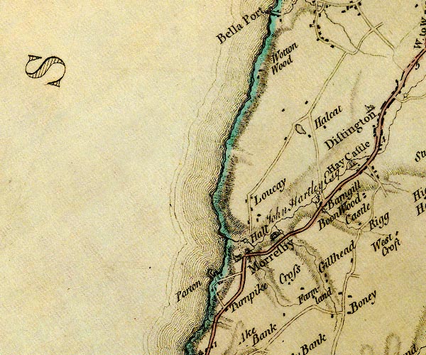 D4NX92SE.jpg "Cross" block or blocks, labelled in lowercase; a hamlet or just a house item:- Carlisle Library : Map 2 Image © Carlisle Library |
|
|
|
||
| evidence:- | database:- Listed Buildings 2010 placename:- Rosehill |
|
| source data:- | courtesy of English Heritage "ROSEHILL, HOUSE AND ADJOINING WALL / / / MORESBY / COPELAND / CUMBRIA / II[star] / 76143 / NX9909820298" |
|
|
|
||
| evidence:- | database:- Listed Buildings 2010 |
|
| source data:- | courtesy of English Heritage "GARDEN BALUSTRADE, SUPPORTING SCULPTURE, TO REAR OF ROSEHILL / / / MORESBY / COPELAND / CUMBRIA / II / 76144 / NX9911520303" |
|
|
|
||
 Lakes Guides menu.